Since WWII, until recent years, many people worried about the gradual decline of Kings Weston house and grounds during continued institutional use. No less so than when the building was in occupation By Bristol College of Science and technology. Initially moving departments from Ashley Down Campus in 1961, their plans for an extensive concrete campus and the change into a university caused local alarm, the scale of the planned facilities concerning even the Council Planning department. Eventually, resistance to the proposals meant the college were forced to look elsewhere for new premises, landing on a site outside Bath where Bath University was eventually founded.
However, not everyone at the college was oblivious to the importance of Kings Weston house. Appropriately enough, it was the architecture department that were installed under the headship of Professor Kenneth Panter. He was a man with the dedication and knowledge to begin restoration work on the building and reverse some of the vicissitudes inflicted on the place since 1938. Since that time the house had become a buildings site, before being hastily patched up for wartime occupation by the military. At the end of hostilities, it became the meanwhile home to Lawrence Weston a primary school. Neither of these temporary uses of the building had much care for the heritage features of the property. By 1961 it was described as “seedy and down-at heel”, with “tottery” chimneys and broken windows. The school had covered the mahogany doors with white paint, and the collection of paintings had been moved to the safety of the city Museum and Art Gallery.
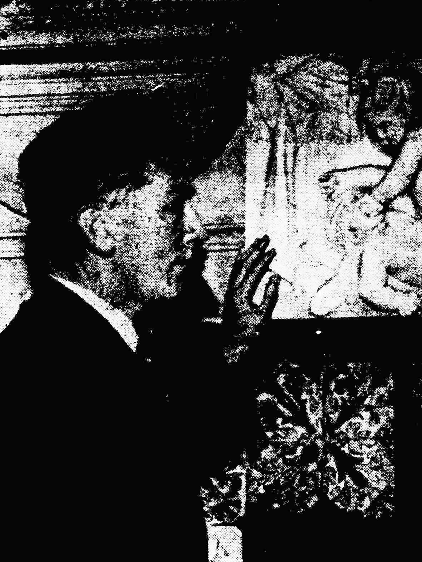
the only photo found of Professor Panter posed in front of one of the fireplaces.
Professor Panter commissioned urgent works to halt decay, but perhaps the biggest challenge of his eight years with the house was repairing the famous skyline. The monumental chimney arcade had been dismantled between 1959 and 1960, the Ministry of Works having “agreed that the chimneys must be taken down because they are actually dangerous.” Scaffolding had been in position so long that it was “in danger of taking root”, was “festooned” around the remains of Vanbrugh’s chimney arcade.
Recognising the importance of the chimneys to Vanbrugh’s design, Panter secured public money to rebuild them. Finally, by September 1968 the press was able to report that a new Doulting stone arcade was being hoisted into place. Towards the end of the department’s time at Kings Weston, Professor Panter was able to proudly tour reporters round the restored building with 120 students filling its rooms. Many works had been undertaken so fastidiously that the efforts required could hardly be guessed at. The hanging staircase had new beams inserted imperceptibly to replace failed Victorian ones, the ceiling of the Saloon at the front of the house had been strengthened with steel beams threaded carefully through the historic fabric, and historic plasterwork was consolidated and pinned back to walls and ceilings.
A rare view of Kings Weston house without it’s famous chimneys. Painted by George Holloway, this must date to between 1960 and 1968 when the chimneys were rebuilt.
The newspaper reported the headless statue from the Echo had been retrieved and that the Professor was offering a reward for the student who succeeded in finding its lost head in the grounds.
As they toured the ongoing works, government minister Lord Kennet and Lord Hailes, chairman of the Historic Buildings Council, praised the school of architecture for their work to reinstate the chimney arcade. The school had spent more than £40,000 on works, £10,000 on the arcade alone, with the bulk of that having been secured from the HBC. This was Panter’s crowning achievement at Kings Weston. He continued with the architecture department when it moved to the new bath Campus in 1970 and the next organisation to occupy the house, Bristol Constabulary, were far less caring of the building.
We can’t find much more information about Professor Kenneth Panter and his efforts at Kings Weston. It’s a shame that, as someone so closely involved with protecting the house, his role is not better known. Naturally, there’s little evidence of his work left now, but that’s just what good restoration should be.
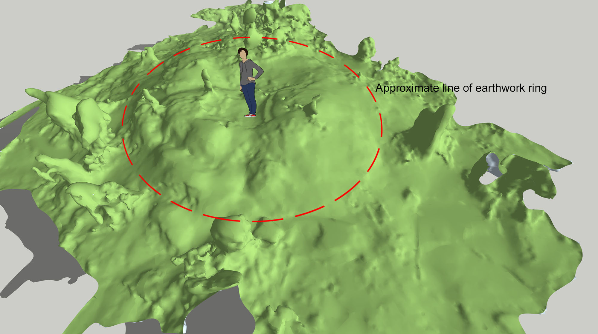
One historic feature of the estate remains shrouded in mystery: the lost windmill on Kingsweston Hill. By chance we rediscovered the remains on a recent walk across Kingsweston Hill, and they remain as a pronounced landscape feature. It’s often been mistaken for a burial mound, of which there are several across the hill, and occasionally as the remains of a Roman signal station or lighthouse.
The location of the old windmill on Kingsweston Hill in relation to other features.
The windmill shown on the 1720 estate plan with a roof and sails.
Already, by 1772, it was described as an ‘old’ windmill and is shown on the estate plan of that date standing just within the boundary of the Tithing of Kings Weston. The earliest reference to it appears to be from an earlier such plan from 1720 where it’s shown, perhaps emblematically, as a tower with a rounded top and four arms for sails, but, surely an “old” building would have stood for more than 50 years? Had it already fallen into disrepair by 1772? The origins of the building are unclear.
The remains surviving on the hill are now hidden somewhat by self-seeded trees that have scattered themselves across the site, but close inspection is worthwhile. There remains a significant mound with a hollow dip in the centre. Loose stonework sits half-buried around the remains and covered in ivy. The ring is about 7m in diameter and 1m in height, but the outline of the original building is likely to have been blurred by the walls falling outwards giving it a broader outline. It was clearly a circular masonry tower when first built.
It occupied a prominent and fittingly exposed location on the hill until trees grew up encroaching onto the open downland in the Nineteenth century. The wind coming up the Severn must have proven a regular if occasionally violent source of power. The mill had certainly fallen out of use by 1768 when a French Colonel was sent to spy on British interests. He recorded that the tower of the old mill was in use as a lookout in times of war, indeed, it was drafted into use for such in 1804 when a flagstaff was erected on it for signalling during the Napoleonic Wars.
The windmill is depicted punctuating the skyline of Kingsweston Hill in 1799. Blaise Castle is visible to the left of the foreground tree.
Several Georgian drawings and prints confirm that the tower remained to a substantial height and remained a significant feature, complementing the silhouette of Blaise Castle folly as an eyecatcher on the horizon. Perhaps its strategic military use ensured it was maintained at least as long as the country was threatened, but by about 1820 it vanishes. Its fate is as unclear as its origin; perhaps it was dismantled by the 22nd Lord de Clifford, robbed for its building material, or dismantled as a handy source of stone to burn in the nearby limekilns. Whatever happened to it, the surviving earthworks present an intriguing opportunity to excavate it and discover its secrets!
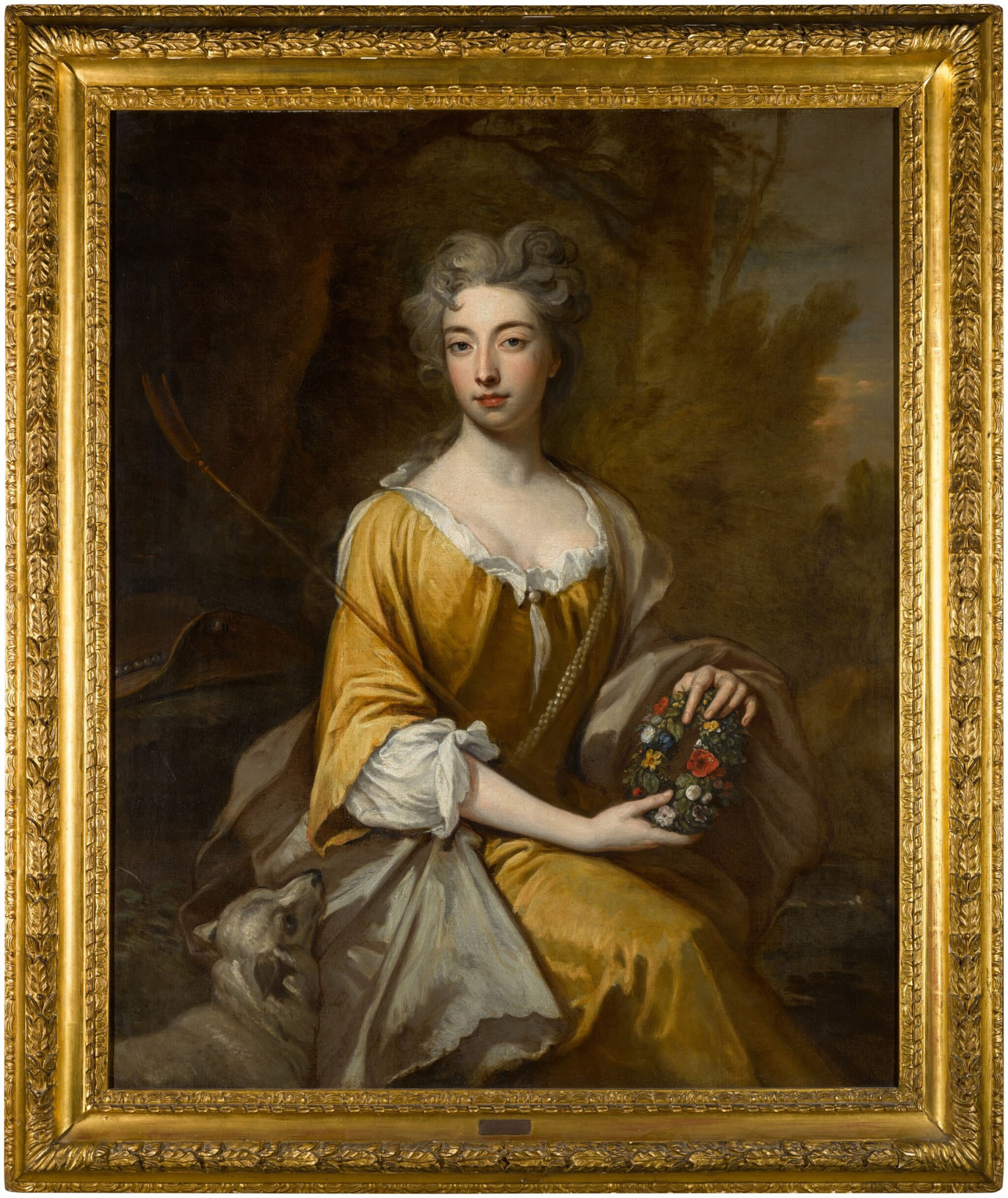
KWAG usually scans archives, libraries, auctions, and private collections in search of new pieces of the Kings Weston history jigsaw, but we recently came across something that had evaded our radar last year. Kings Weston house is already home to a majestic full-length portrait of Lady Elizabeth Cromwell, who married Edward Southwell in 1703. Edward, or Neddy, went on to rebuilt the mansion later that century, but his wife was at least his equal. Around the time of their marriage Lady Elizabeth – Betty to her friends and family – became the muse of Godfrey Kneller, one of the foremost portraitists of his age. Kneller made more paintings of Lady Elizabeth than any other sitter, about ten more-or less.
Reputedly he was obsessed by her and resented her marriage to Southwell, but continued to paint her subsequent to that union. In July 2022 a significant painting we’ve been unaware of went under the hammer at Sotheby’s. It depicted Lady Elizabeth in a fashionable pose, as shepherdess seated in a landscape, holding a floral garland, a lamb by her side. We’ve not yet worked to establish whether it was one of those that hung at Kings Weston, the Southwell’s London house, or elsewhere. With an estimate of £20,000-£18,000 it’s perhaps best we missed the sale!
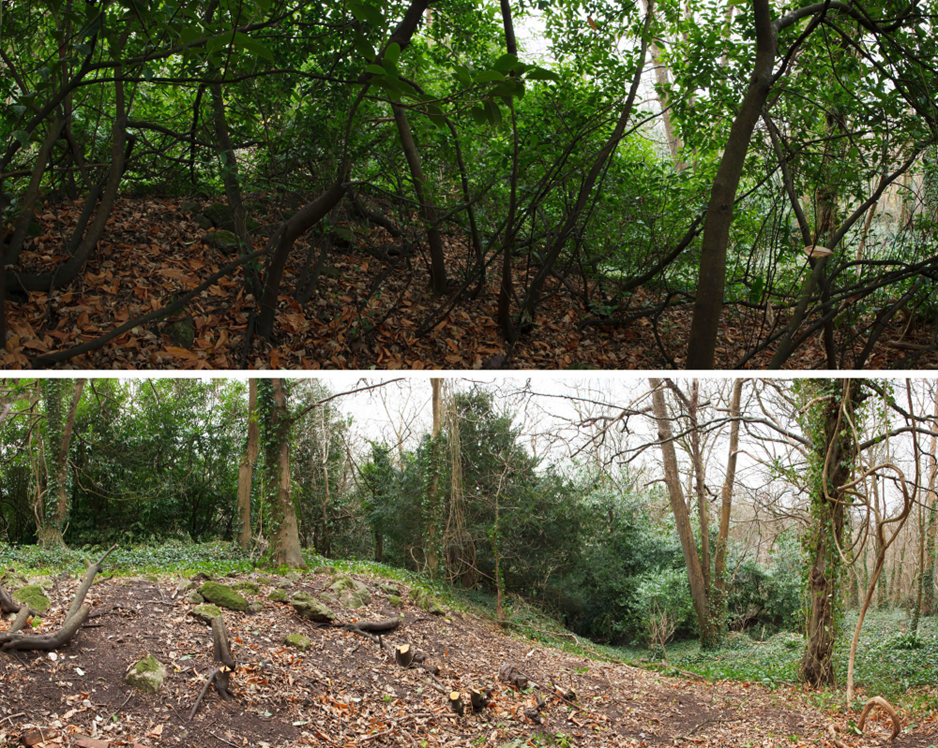
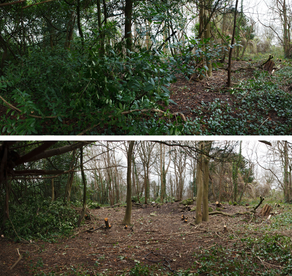
The last volunteer working party of 2023 continued work around the View Garden adjacent to the old Stables on Napier Miles Road. Cherry laurel was again our target and the dense thickets along the west side of the lost garden area as well as another spot of interest; this was what looks to be another designed rockery area next to the original viewpoint at the far north-west of the garden site.
The thicket of laurel along the edge of the path to the viewing platform (on the left) taken looking north-west from the sweet chestnut tree.The same cherry laurel disappears to reveal the impressive sweet chestnut.
It’s been satisfying to address the encroachment of the laurel across this area, where felling gives such an instant impact. Volunteers worked quickly on the area around the viewpoint, transforming it before lunchtime and revealing a huge sweet chestnut tree that much have once formed part of the Victorian garden design. Sadly, any prospect from the viewing point across the Severn would be impossible to restore for the number of trees that now obscure it.
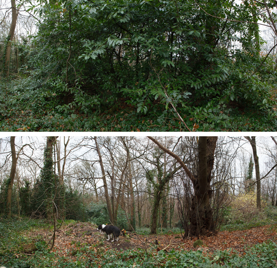
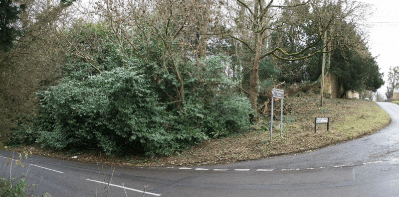
Animation showing the impact of removing the invasive cherry laurel from the road junction between Kings Weston Land and Napier Miles Road.
Work along Kings Weston Lane Removed the errant laurels that threatened to push out across the road. The removal of these has also improved the visibility on the awkward junction with Napier Miles Road and the entrance to Kings Weston house itself, the removal of the dense shrubbery having opened a clearer view in the mirror used to check oncoming traffic coming up the hill.
The open space now restored on this corner still retains the native trees that have seeded themselves through the laurel, but the rest would be a good spot for the grubbing-up of brambles and reseeding with meadow grass. The now-open bank along Napier Miles Road also offers an opportunity for bulb planting in the Autumn.
Clearance of the area seen looking from the south, with the Victorian rockery in the middle distance.
After it first featured in the popular BBC series in 2017, Kings Weston house again took a cameo role in the Doctor Who Christmas special last month. Much of the episode ‘The Church of Ruby Road’, the first full episode with new Doctor, Ncuti Gatwa, was filmed around Bristol, with the stair hall at Kings Weston the backdrop to a nasty accident involving Davina McCall and a Christmas tree. Fortunately, (spoilers) the Doctor returned through time to save her.
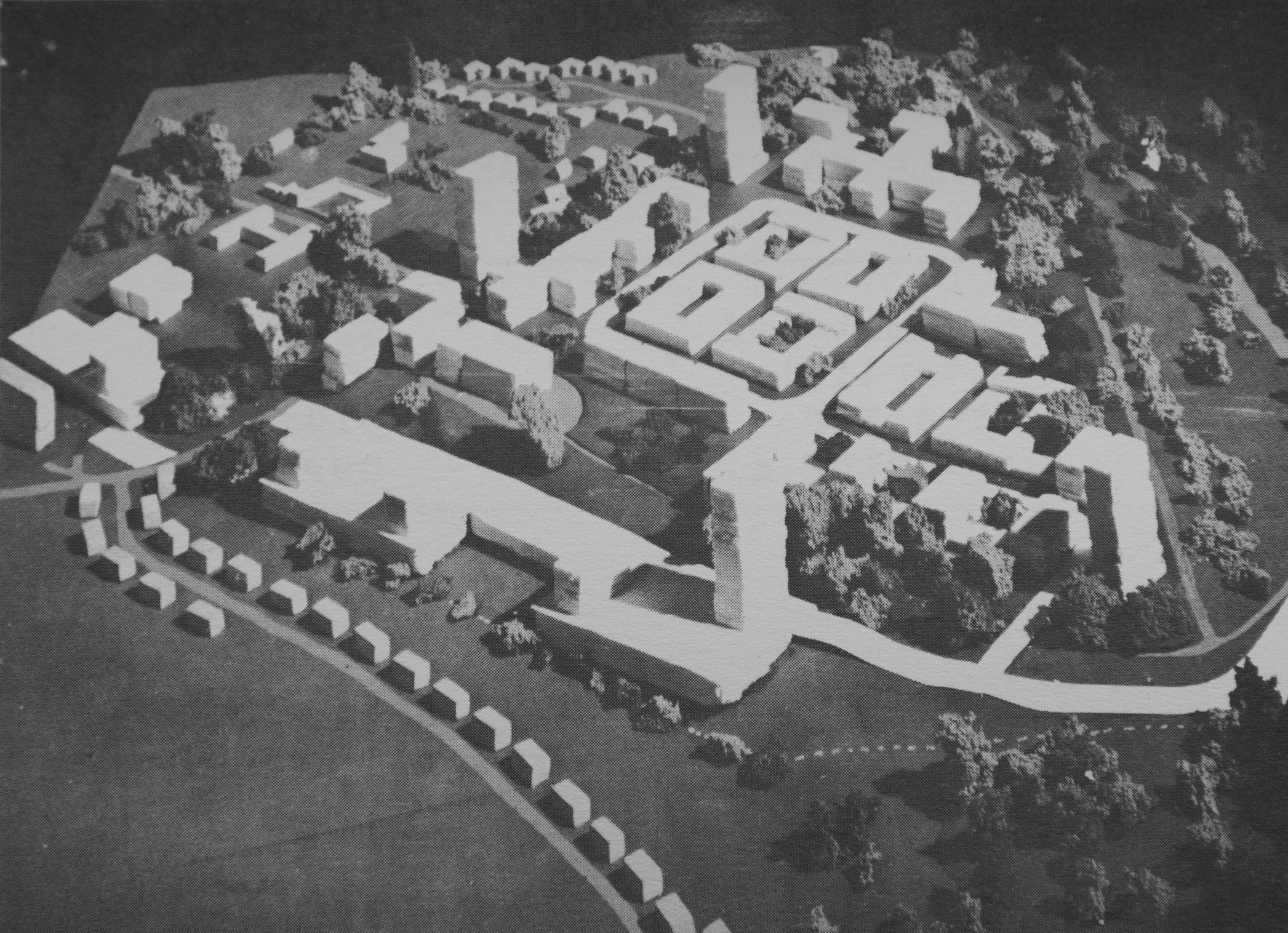
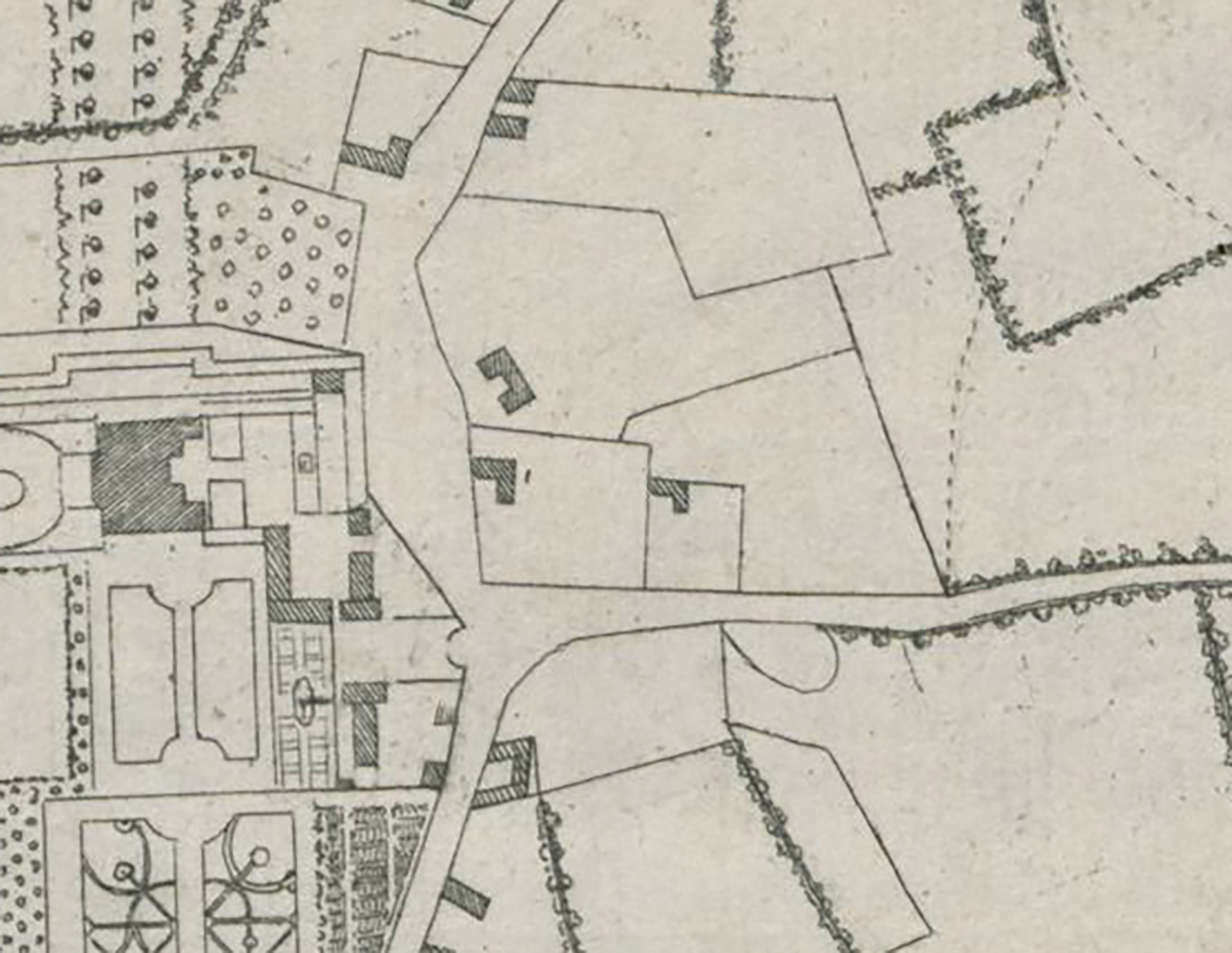
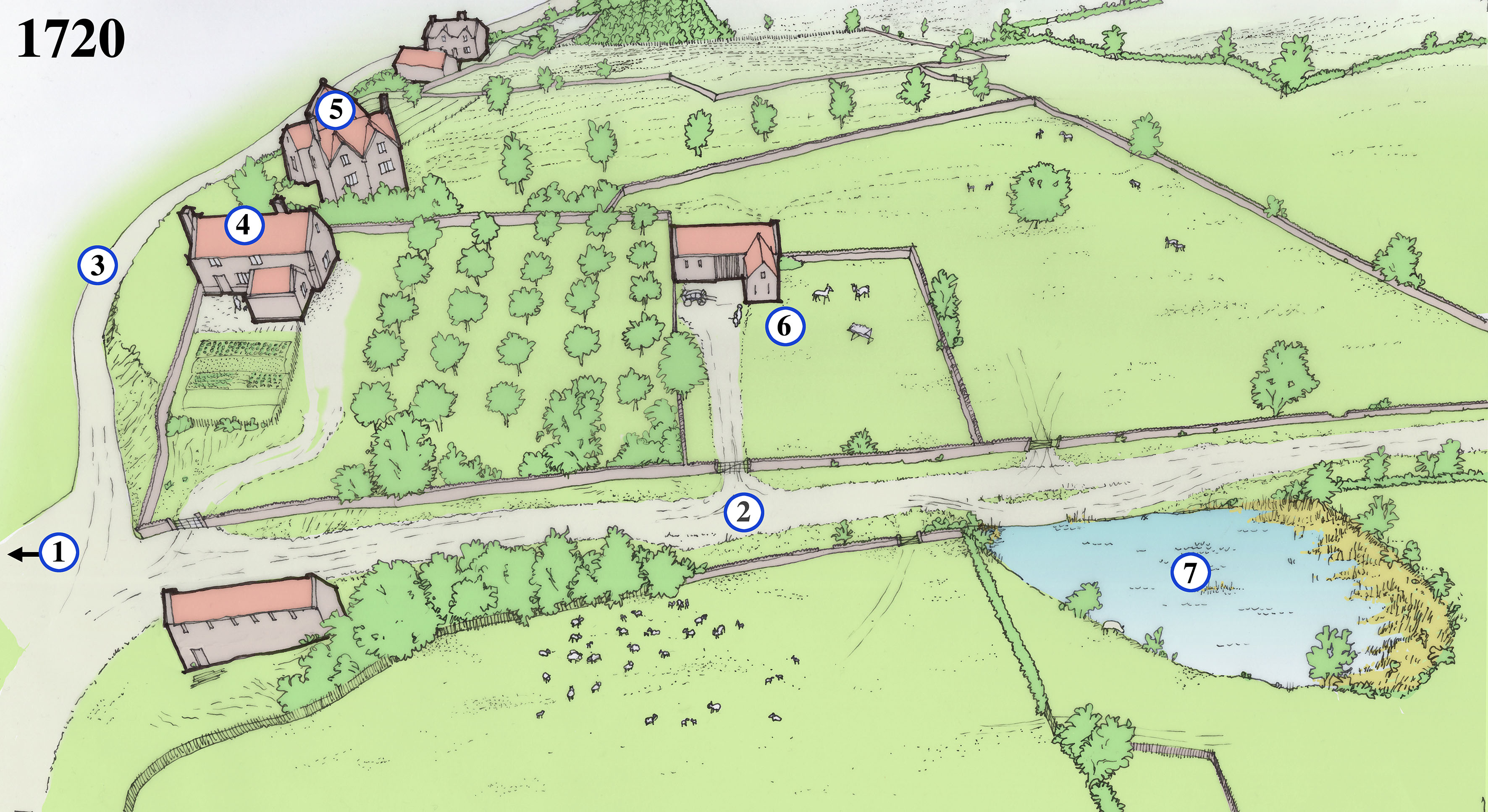
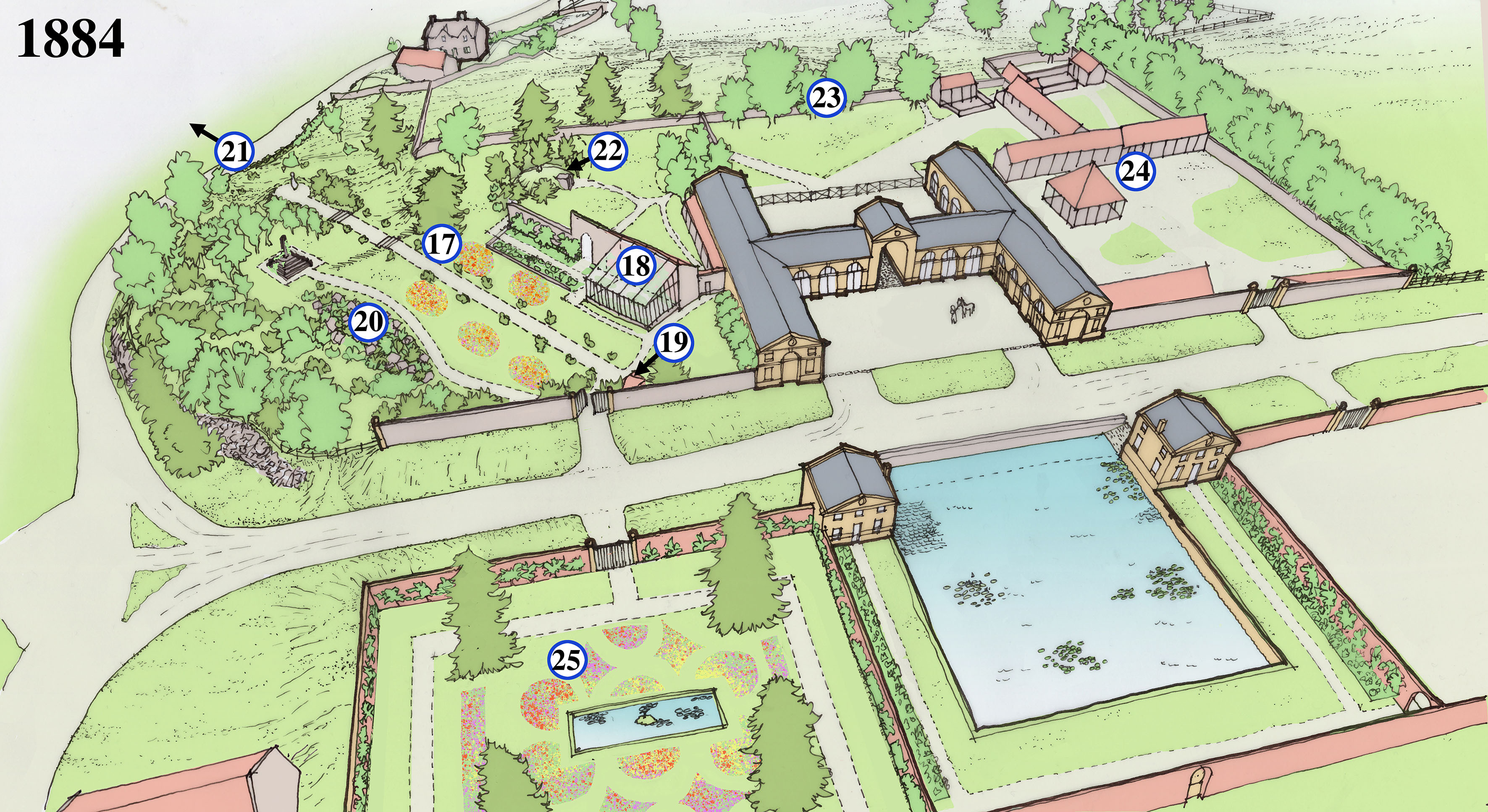
With a renewed focus on the area, it’s worth looking again at the history of the View Garden, once referred to as “the gem of the whole garden”, and lilypond to understand their significance. There’s enough map evidence provided by two important estate surveys of 1720 and 1772 to appreciate the colossal scale of the works undertaken from 1763 to transform the area into the walled garden and stable complex that survives today as a series of Grade II-Star listed buildings split across Napier Mile Road. To help understanding and appreciation we’ve created a short series of sketch views of the area at key moments in their development. Each image has a numbered key with the individual points described below…
1720
Halett’s estate plan of 1720 is an important record of Kings Weston just as the mansion had been completed, and before new garden works were begun. Although broadly accurate it provides scant information on the appearance and use of the area east of the main house. A later engraving gives a bit of detail, but the reconstruction here can only be described as speculative despite being based on these sources. Our reconstruction depicts an agricultural landscape with fields, orchards, and gardens separated be dry stone walls and hedges, with a few scattered traditional vernacular styled buildings. One of these was perhaps the source of a carved window stone, later built into the glasshouse wall in the 1770s.
1. The road entrance to Kings Weston house approaches from the east as it does today. The present gatehouse and wall are Victorian and of 1903, and it’s not clear what the gates would have looked like at this time.
2. The present Napier Miles Road is a rural track leading from Kings Weston House to Henbury, and the parish church there.
3. Kings Weston Lane is another agricultural track, leading to a few scattered cottages and farms. The lane passes through an ancient hollow-way where centuries of water have washed off the hill and created a gully. Several gullies like this are distributed along the escarpment edge.
4. A number of houses occupy plots of land to the east of Kings Weston house. Most will have been for labourers tied to the estate. This house was on a roughly east-west alignment, and possibly reused the manor’s medieval chapel that would have fallen out of use at the Reformation. Another medieval chapel survived as a cottage in nearby Lawrence Weston until the mid 20th century.
5. A larger house stands above Kings Weston Lane, uncomfortably built into the steeply sloping land that descends towards the north. From its size it’s likely to be a higher status house than those around it. Could it have been an earlier site of the manor, before the current site was established in the Tudor period? A fragment of stone salvaged from the glasshouse wall was recorded by us in 2016.
6. A smaller building in a small plot in this location may have been a barn or other agricultural structure.
7. Shown on the 1720 plan is a large natural pond to the south of the lane to Henbury. This ill have provided a useful resource for the farms, and likely produced ice in the winter for the earlier ice house behind the mansion.
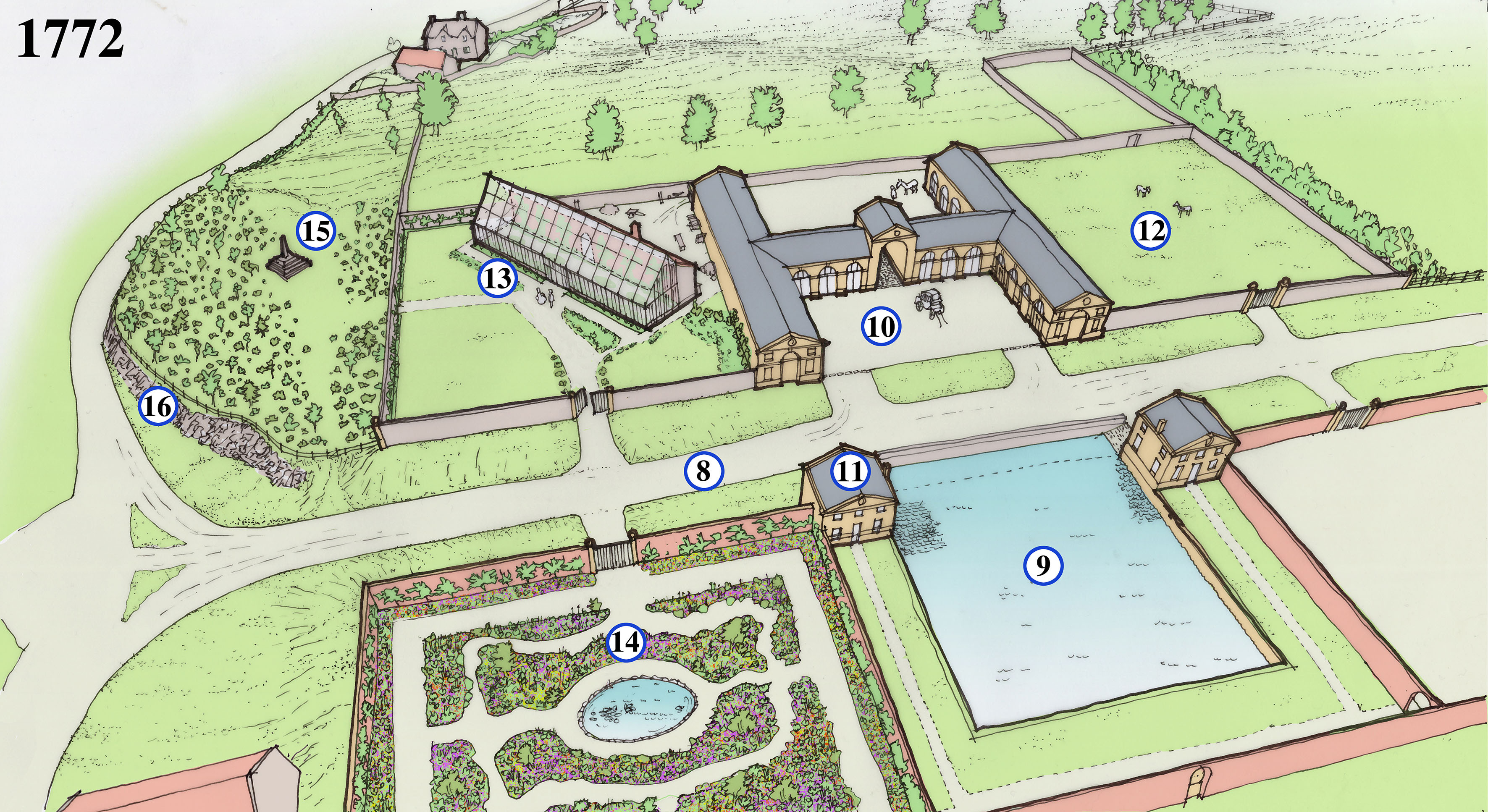
1772
Isaac Taylor’s comprehensive estate survey was undertaken between 1771 and 1772 and includes a number of radical changes east of the house, a striking transformation from rural backwater to thriving estate hub. There are, in fact, two maps of the area drawn by Taylor, each showing slightly different features, perhaps finished at slightly different times. Both show how the old houses and boundaries were largely erased. From 1763 onwards the architect Robert Mylne enacted the third Edward Southwell’s ambition to clear away all the old stables and service buildings from beside Kings Weston house and extend the landscaped parkland to fill their space. Together, architect and client instead created a new set of buildings set in a series of rectangular walled compartments on a grid plan, providing an ambitious integrated design accommodating key estate functions, various gardens, glasshouses, and an impressive carriage house and stables complex. This was all to serve the main house with produce and flowers and service the estate’s transport needs.
8. The lane to Henbury has been realigned to become a broad straight road with grassy verges either side. The new road is designed to have a visual impact when viewed from the gates to Kings Weston house from the west.
9. The natural pond is formalised into a square pond which could be stocked with fish for the kitchen as well as providing water for the gardens and stables. Ice would be collected here in the winter for storage in the icehouse. Ramps and a platform below water level are designed to wet carriage wheels to prevent them from shrinking in hot weather and losing their metal rims.
10. The centrepiece of the new complex is the grand and formal carriage houses, with stables in the wings beyond the archway.
11. Matching the stable block in style are two lodges built framing the pond; One provides a gardener’s cottage and the other a seed house.
12. Paddocks for horses are probably intended for the north-eastern quarter of the complex.
13. Set in its own compartment and angled to maximise exposure to the sun, the glasshouse at Kings Weston and was one of the largest in the country was built in about 1771. A tall masonry wall at the back incorporated a hidden hot air heating system powered by a furnace at the back. The glasshouse quickly became a focus for Sophie Southwell’s interest in horticulture and where she nurtured her interest in growing exotic plants and flowers. It became a much-remarked feature of the estate during the 18th Century.
14. Produce gardens were kept to the southern compartments behind the pond and this walled area. This area with better access to Kings Weston house was a flower garden, laid out on a broadly regular plan but with eccentric windy paths adding interest. Flowers would have been grown to supply the house with attractive displays and perfumed blooms, but also offered a more intimate garden experience to the landscaped parkland then laid out around the mansion. An oval pond at the centre would have ben used to help watering and create an attractive centrepiece to the garden.
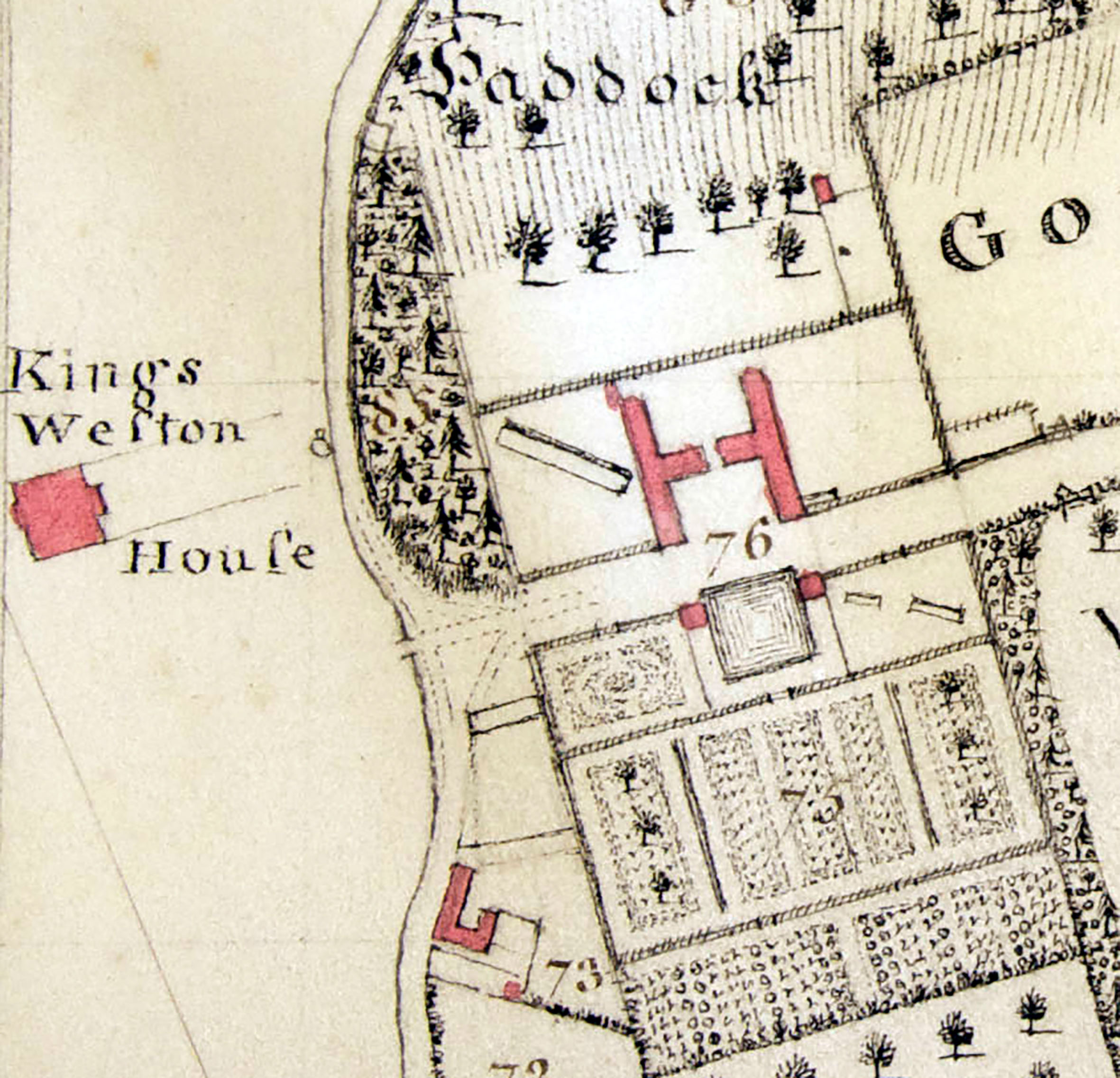
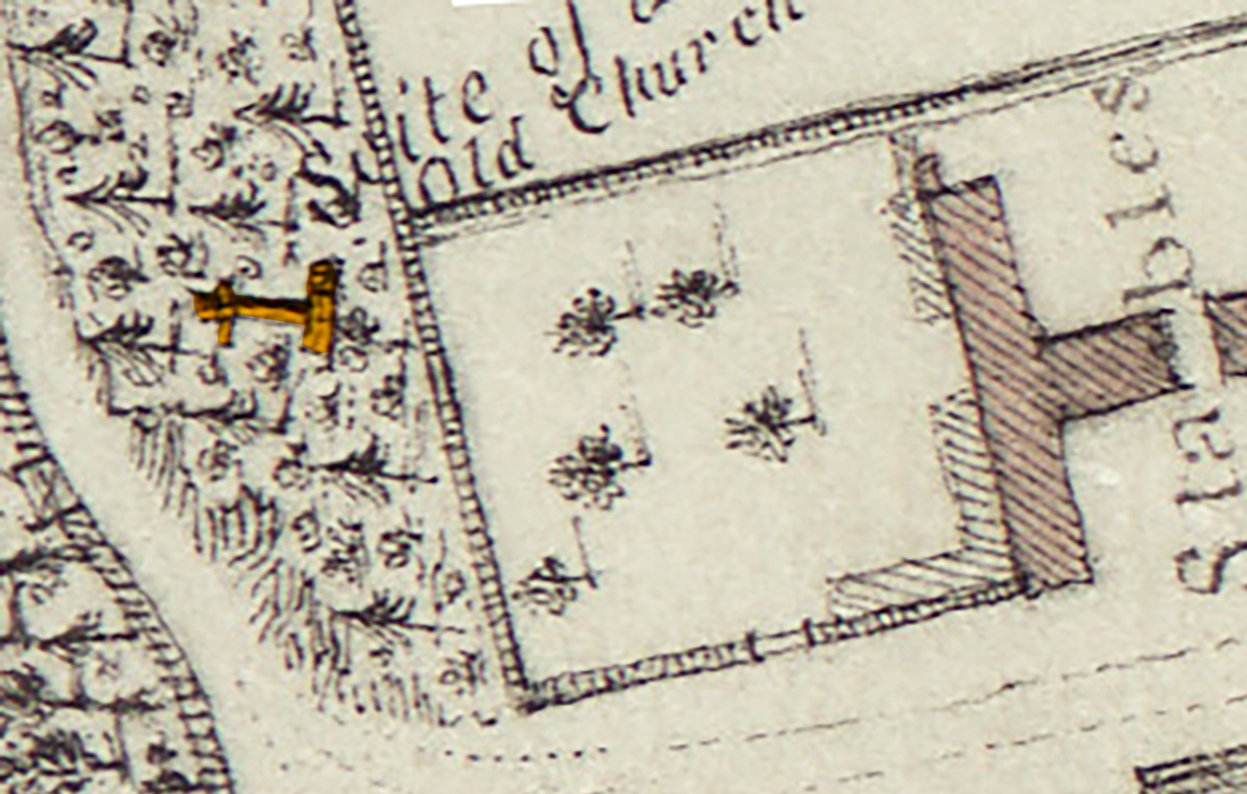
15. One plan of this date shows a cross here and describes a “site of an old church”. Later maps show “Bewy’s Cross” standing here. In 1720 the site was that of a building, so it’s unlikely that the cross was there at the time. It’s speculated that an ancient cross at the mouth of the Avon was relocated to Kings Weston as a garden ornament, though perhaps intended to mark the site of the old chapel. What evidence existed to suggest the church, more accurately chapel, stood here is unknown and lost when the standing buildings were demolished.
16. To create a regular new road to the stables and improve the way down the hill parts of the hill are quarried out and pushed back to leave rugged rocky cliffs against the road. New plantations are planted above them to naturalise their appearance and as a setting for the cross.
1884
The rigid Georgian plan and ambitious scale of the walled garden complex provided well for Kings Weston for over a century, with little change. The ownership of the estate had passed from the Southwell to the wealthy Miles family. Changing fashions in garden design and use and a greater demand for service buildings saw some blurring of the rigid boundaries and expansion into the surrounding landscape. The biggest change was the creation of the View Garden, probably laid out in the 1860s. The name is first recorded in 1916 when it was described as “the gem of the whole garden” at Kings Weston.
17. By the 1840s the wall of the north-east compartment is thrown down and the glasshouse and cross brought into a single garden space. About 20 years later a long axial path is laid out on the same alignment as the glasshouse, with two sets of stone steps. Fragments of these survive today. The lawns either side of the path were probably set out with ornamental flower beds. The new garden is christened the “View Garden”.
18. The Georgian glass house is passed its prime and has been rebuilt on a less ambitious scale against its original. The parts no longer covered are turned into more planting beds.
19. A covered garden seat or alcove is built at the head of the axial path, just to one side of the entrance gate, and from which to enjoy aligned views through the gardens. Yews and box trees are planted to lead the visitor along the paths and line the back of the main garden wall.
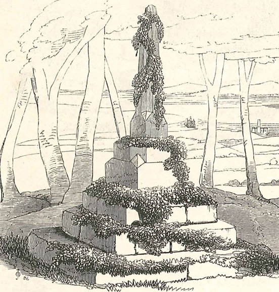
20. Another path is laid out on a more picturesque winding course, taking in a large new rockery on its way to a small clearing around the medieval cross. It may have been whilst creating the rockery or the axial path that foundations of a building were uncovered again in the 1860s and again thought to be the chapel ruins. In 1868 the cross was described and illustrated as covered in ivy, perhaps planted for picturesque affect? The view through the trees here certainly had eye-catching views to the Severn.
21. The axial path culminated in a circular viewing platform elevated above the slope of the hill. It enjoyed distant views across the Severn and Avon towards Portishead and Wales beyond, giving the View Garden its name.
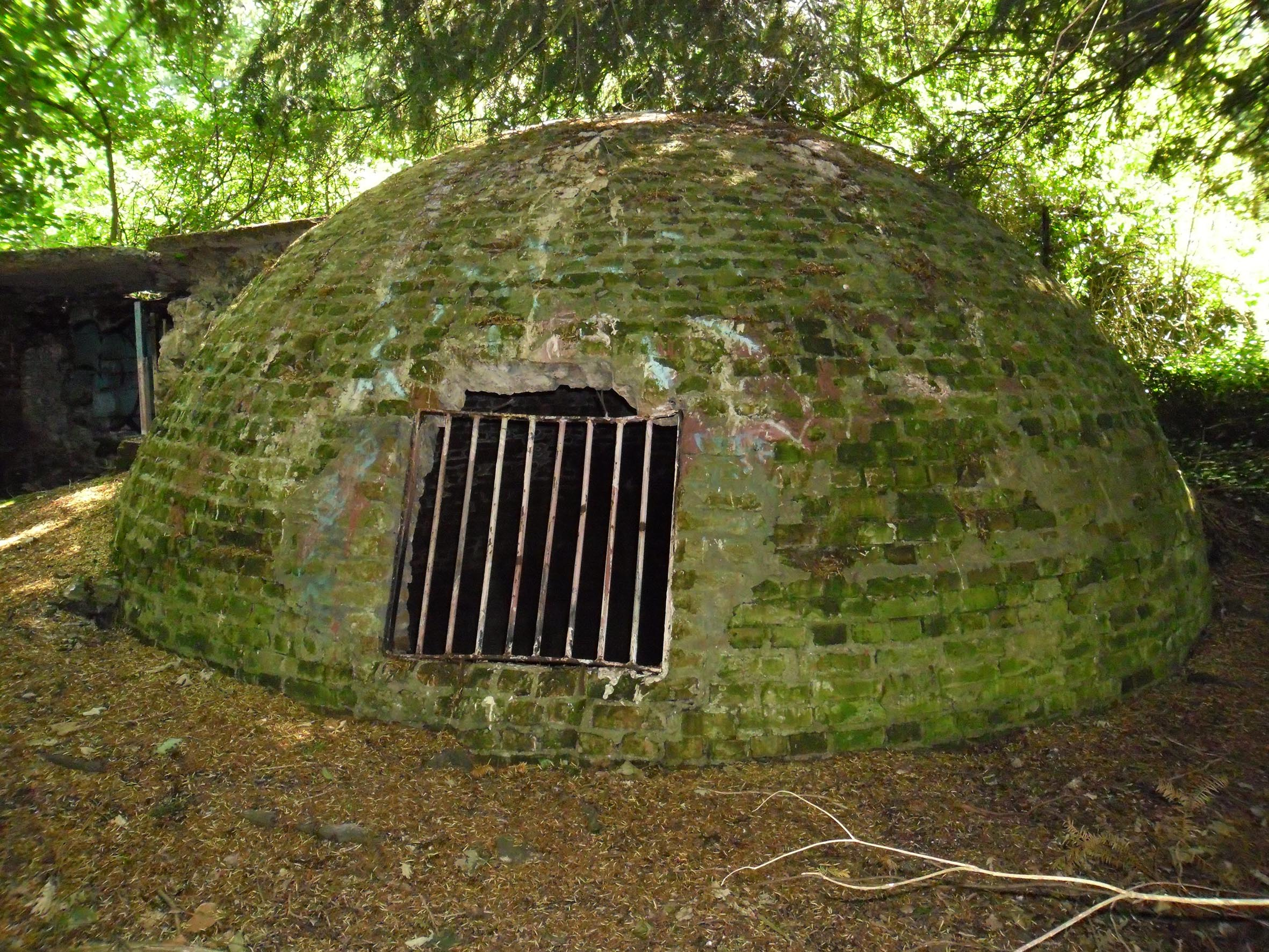
22. The old icehouse behind Kings Weston house was done away with, probably in the mid-Victorian era, and relocated to behind the old glasshouse. It was covered in earth to provide added insulation and planted around with yew trees to protect it from the sun. One yew tree was planted at the very summit of the domed icehouse and remained there until it finally fell in the 1980s, pulling the earth covering with it.
23. The original Georgian rear wall was pushed north with the land built up to form a flat platform, falling away with a steep embankment beyond. The additional space accommodated the icehouse and more paddock and building space.
24. Fox hunting had become a popular recreation activity for the Miles family and more buildings were needed to stable horses and provide storage and dog kennels. These were added to the north of the stables. A woodyard and sawmill were also added in this area.
25. The flower garden had become more formal and less focussed on providing for the house. It’s dominated by four conifers planted around a now-rectangular ornamental pond. Like the View Garden, the lawns were likely planted with floral displays of seasonal bedding plants in the Victorian fashion. This garden would shortly be transformed again, with the conifers felled and a more informal pond and rockery.
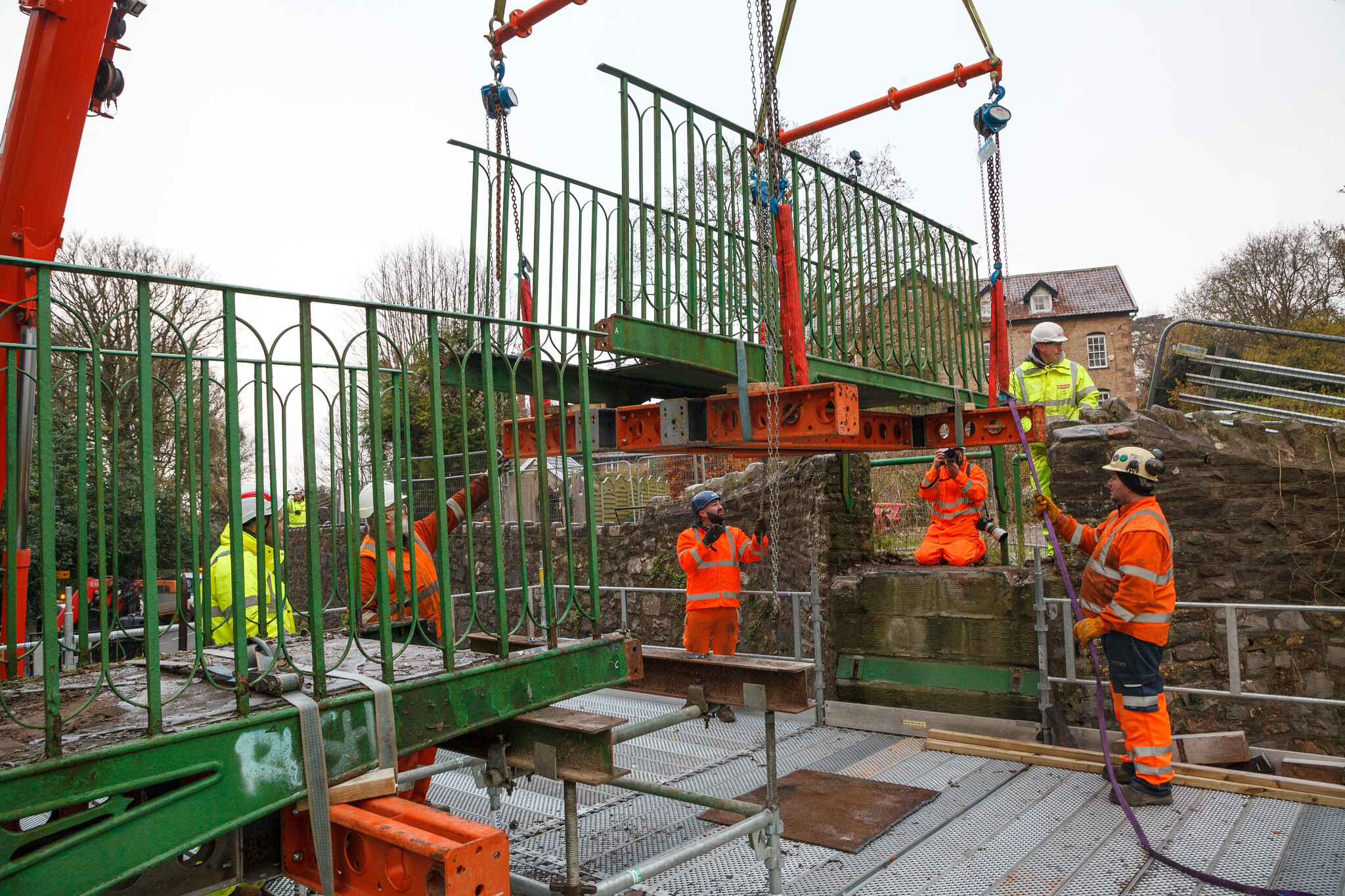
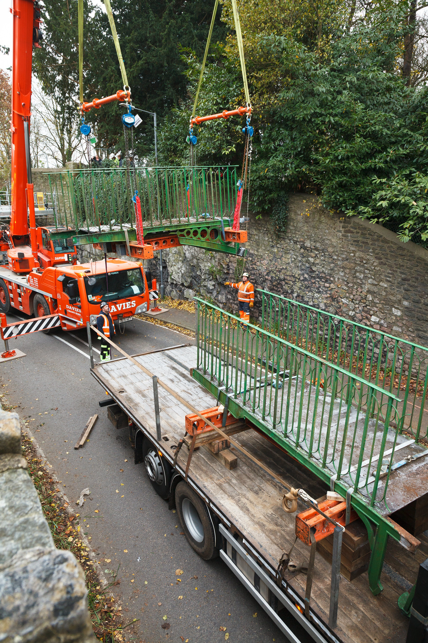
This biggest news this month is the long-anticipated start to works on the Kings Weston iron Bridge. Finally, after eight years of campaigning by local groups work is finally picking up speed. The road was closed on the 27th of November for a supporting scaffolding platform to be erected under the bridge; This would take the weight of the historic structure during the required disassembly. Dorothea restoration, a specialist Bristol restoration company, oversaw the works to strap the main bridge parts to steel cradles and make a few selective cuts to metalwork, separating the bridge into two major components with a number of other elements. The western half of the bridge remained in its original condition, with components held together by iron pegs, molten lead, and just four square bolts. The eastern half had been replaced and repaired at some point in the 1970s when it was last hit.
The first half of the bridge takes flight.
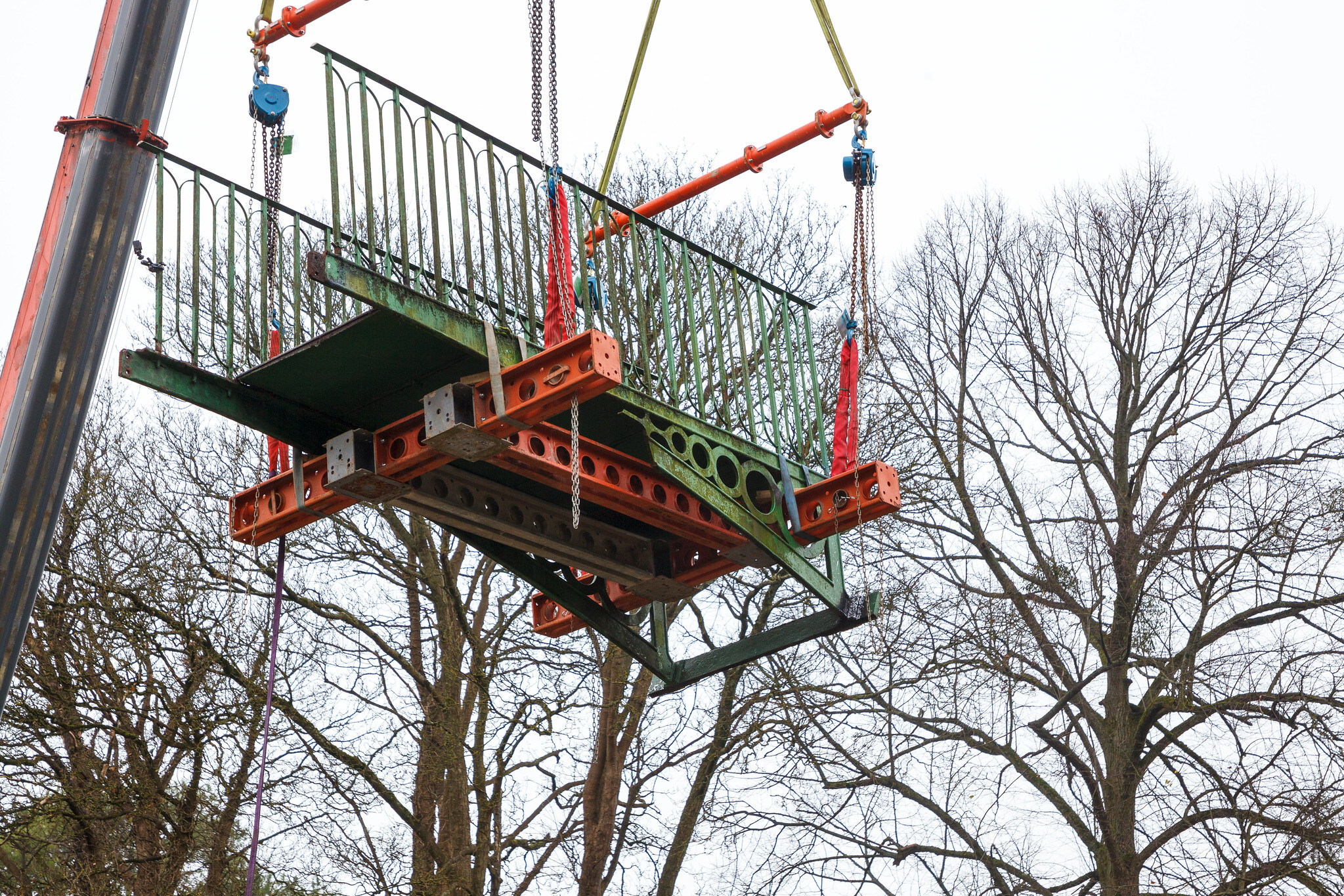
The second half is craned onto the flatbed.
The big day arrived with an early and frosty start on Friday 1st December. Contractors had been on site since 7am preparing for the lifting. A crane and flatbed lorry were positioned on the north of the bridge and final preparations were made to ensure a safe and clean lift.
Eventually, at about 9am everything was in place and the first piece, the central meeting plate of the bridge, was lifter clear. Next came the first of the major sections, starting from the east, which also lifted cleanly and, with some relief, in one piece. As the bridge was dismantled it became clearer how it had been put together originally and how cleaver the design was, but there were still areas of concern. One thing that remained unknown was how the bridge was attached to the abutments, so with some trepidation the western half was edged out only gradually. Fortunately, there were no unknown anchors fastening it back into the stone, instead being fixed in position only by gravity and its own weight.
Each section of bridge, including its lifting cradle, weighed les than a ton. With efficient work by Dorothea and contractors Griffiths the work was finished by 10am and the two pieces of bridge positioned on the lorry for carrying off to the restoration workshop.
The second half to be removed floats above the trees on its short journey to the waiting lorry.
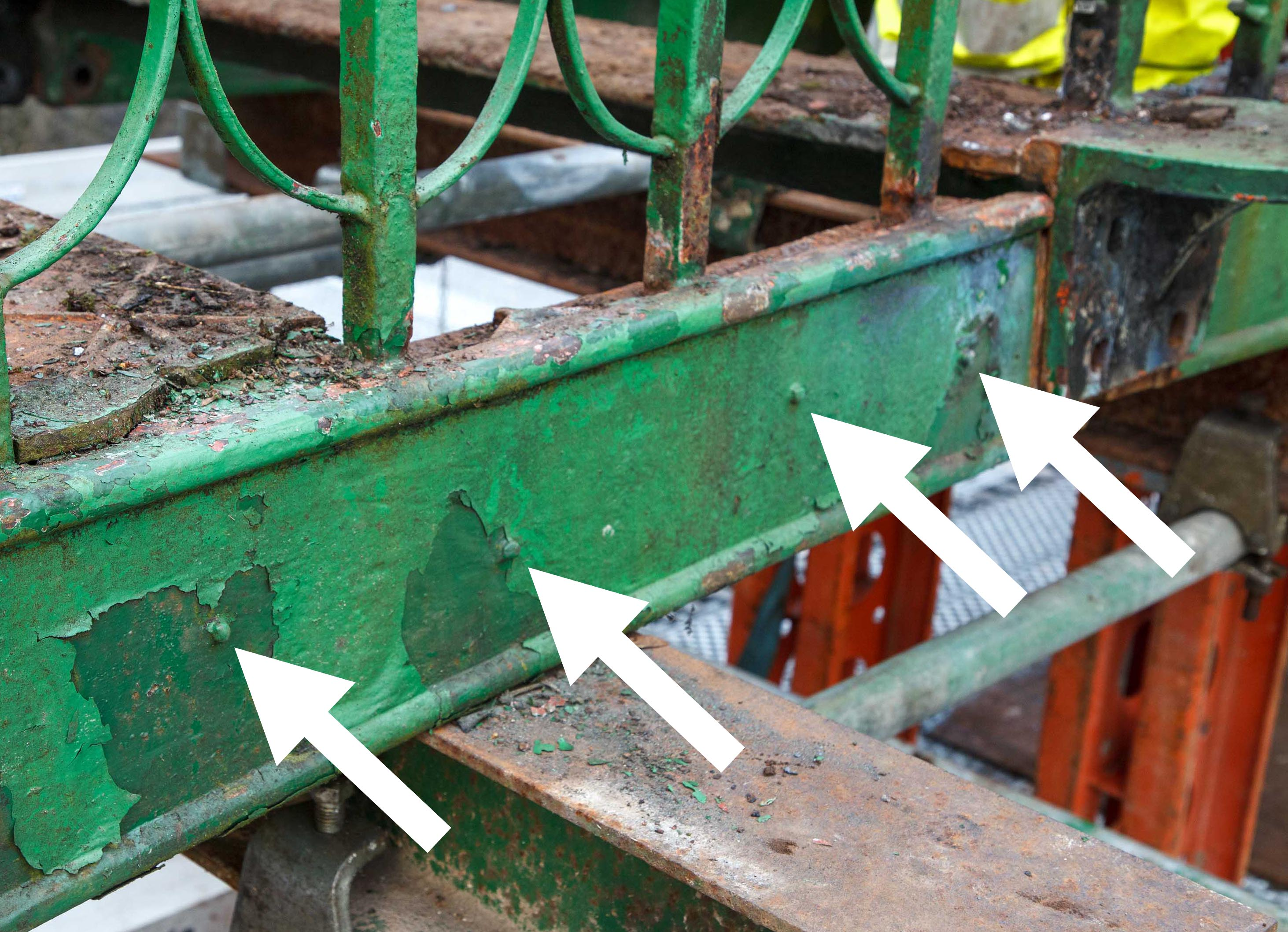
iron pegs found on the south-west arched section of the bridge.
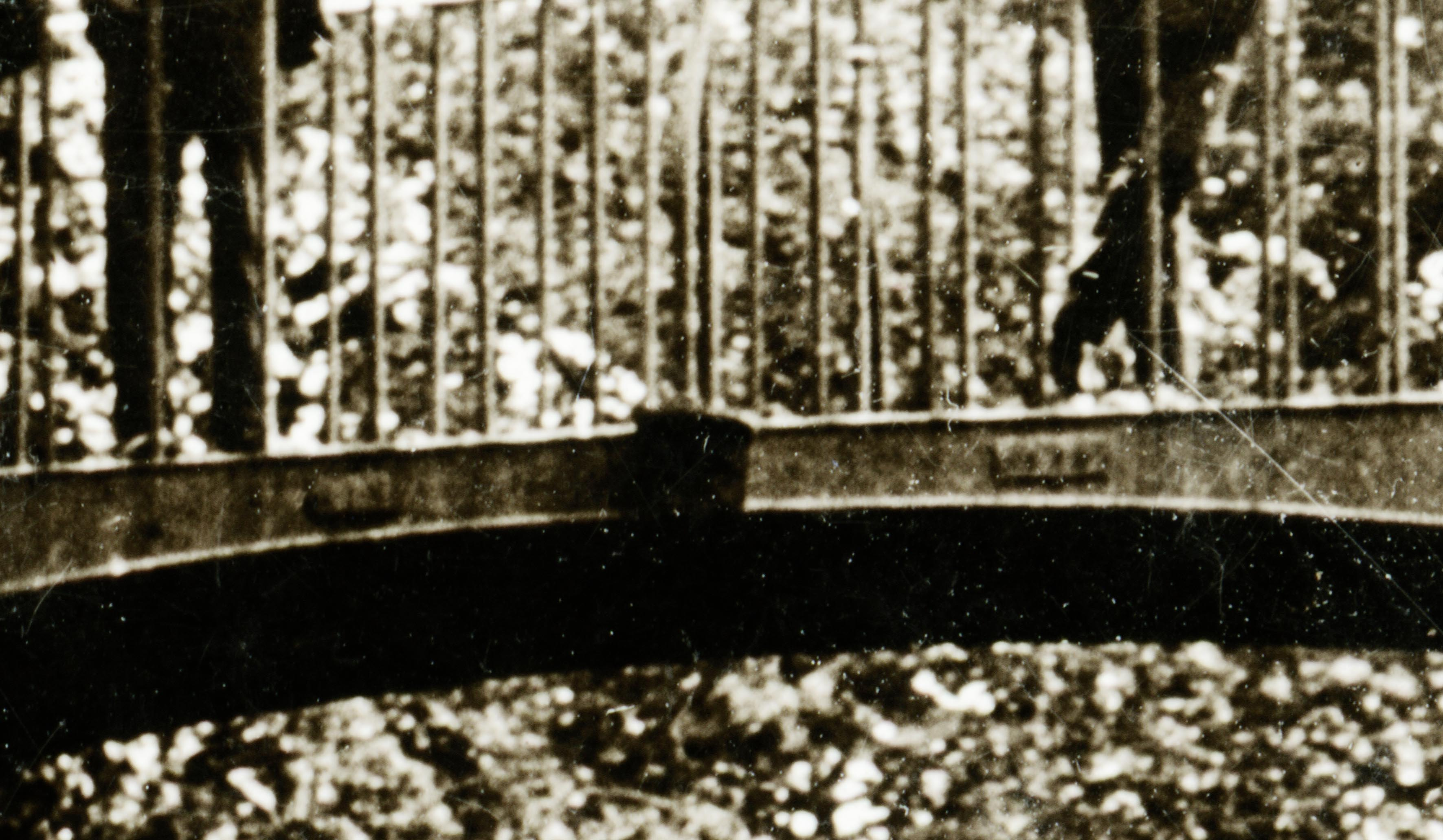
With a detailed inspection one new feature has been identified, one so small it’s evaded notice until now. The two original arched spandrels on the west half of the bridge have tiny iron pegs close to the centre point. Four pegs were identified on the south side, but fewer were identifiable on the north. It was suggested that these once held letters or plaques, and this led us to return to old photos. It came as a surprise to discover that there were indeed plates visible in some early 20th Century postcards that we’d never noticed before. These plaques appear to be the last fragments of a larger inscription, but the photos are not clear enough to read what they said. There may be the letters “K I N” on the left side, suggesting that it may have read Kings Weston on the left and, like similar bridges, perhaps “erected 1823” was on the right? If anyone knows anything about these, what they said, or has any better images, please let us know.
Detail of an old postcard view showing the fragmentary remains of cast plaques.
The road will be closed again for a longer period in January for the main element of the works to start. This will involve the raising of the abutments either side and the formation of new steps. The road will be completely closed from the 15th Jan with a projected reopening by the 3rd May. We hope now that the programme runs smoothly and that we can look forward to a late-Spring inauguration of the restored bridge
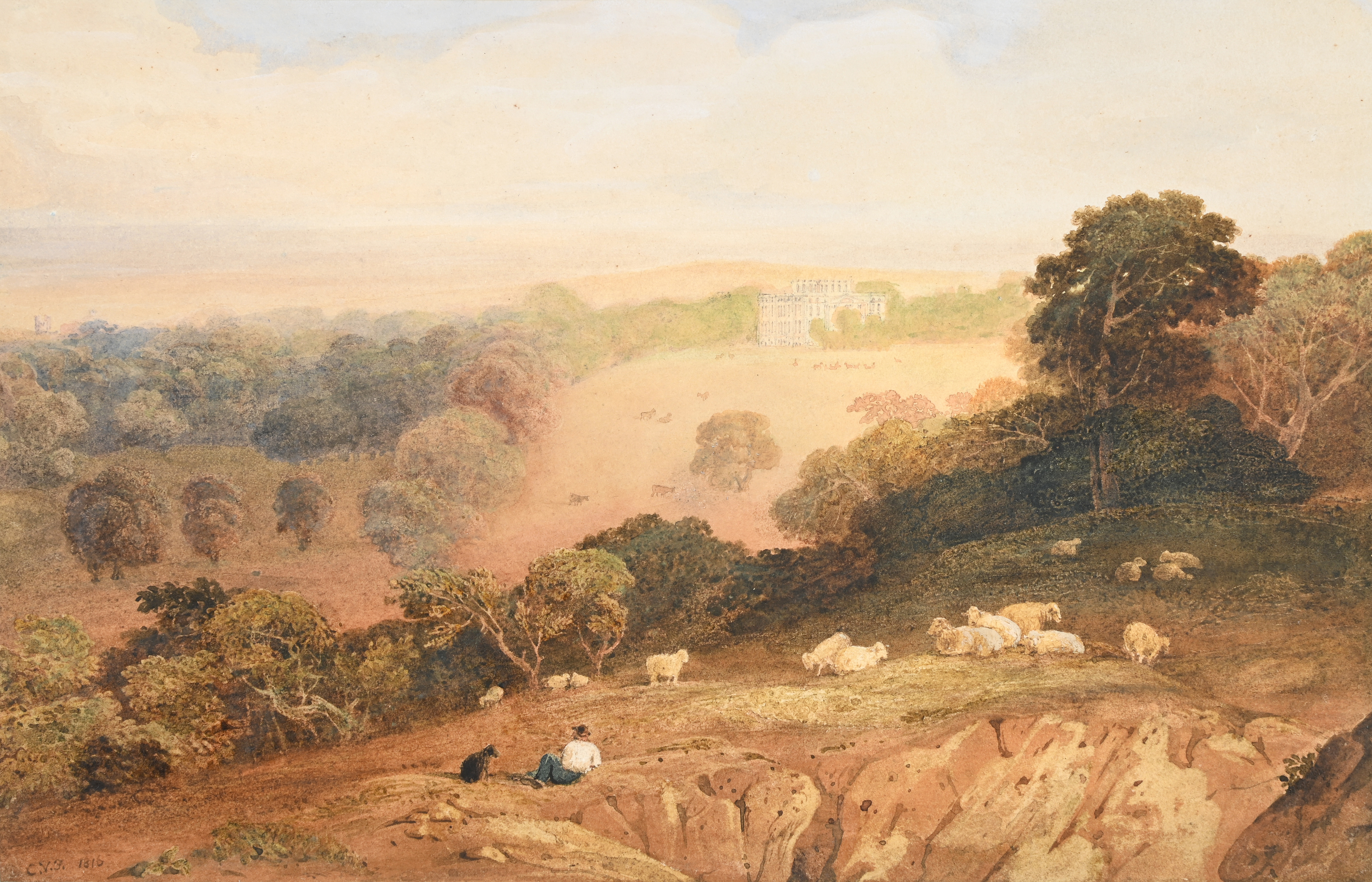
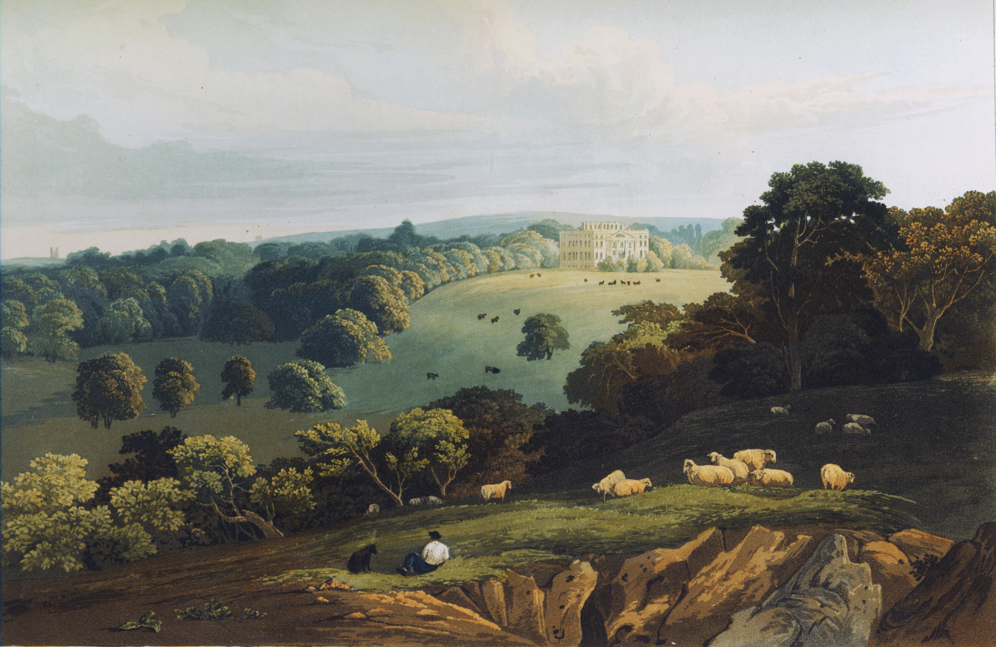
Another painting recently came to auction that’s of Kings Weston interest; it’s a watercolour of the house and park from Penpole Point. It’s a view that’s already familiar to us through one of the most widely published and most attractive prints of the park in the early 19th Century. The artist was the impressively named Anthony Vandyke Copley Fielding (1787-1855) who visited Kings Weston in 1816. It’s not clear whether it was intentionally painted as part of a larger project, but reproduced it found its way into a Series of Picturesque Views of Noblemen’s and Gentlemen’s Seats seven years later.
the original watercolour showing the view of Kings Weston house from Penpole Point. 1816, Anthony Vandyke Copley Fielding (1787-1855). One version of the print copied from the original painting.
This month the news has been filled with a number of serious storms that have brought winds and flooding to several parts of Britain, but 164 years ago Kings Weston also experienced a shocking gale.
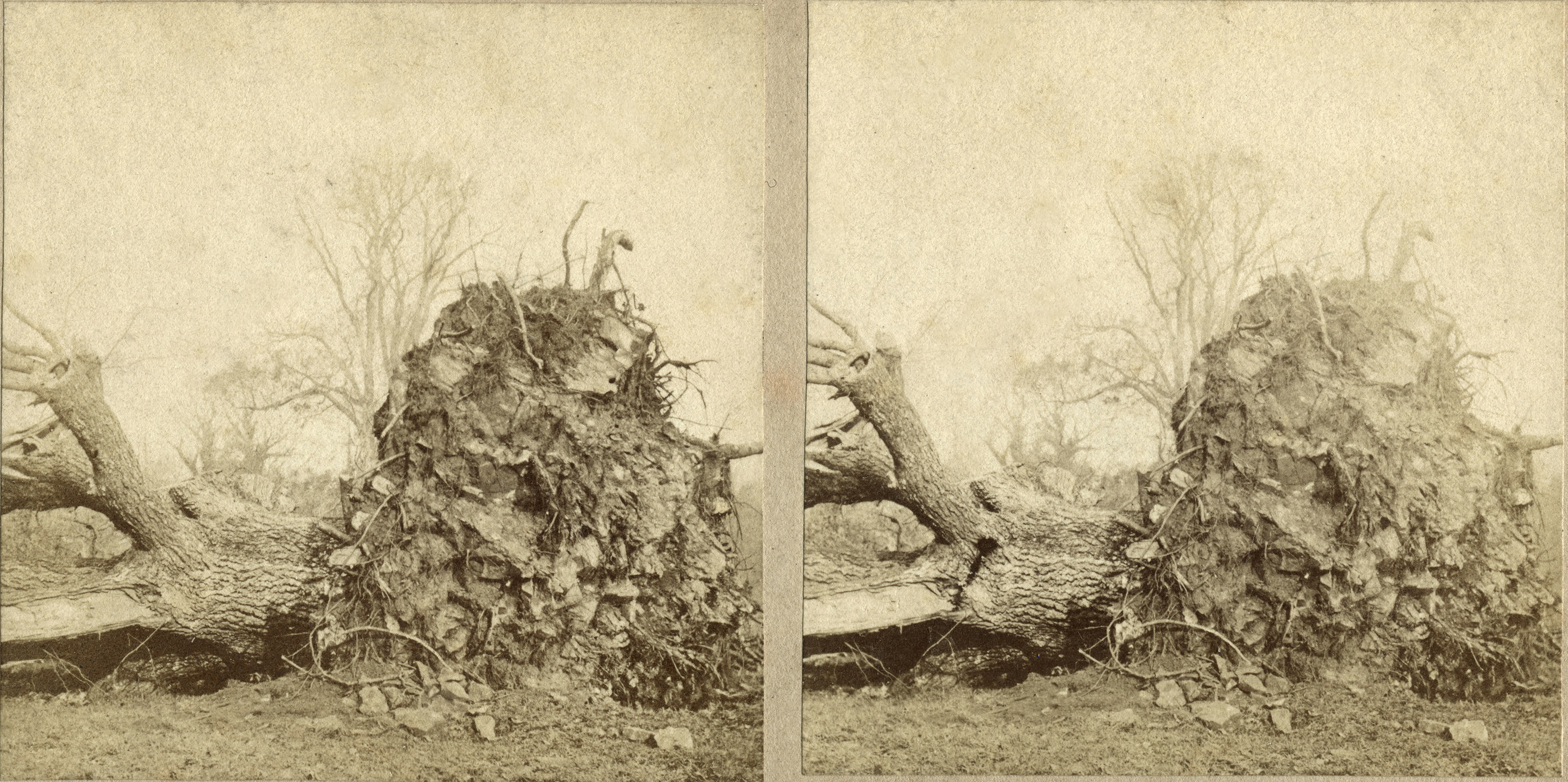
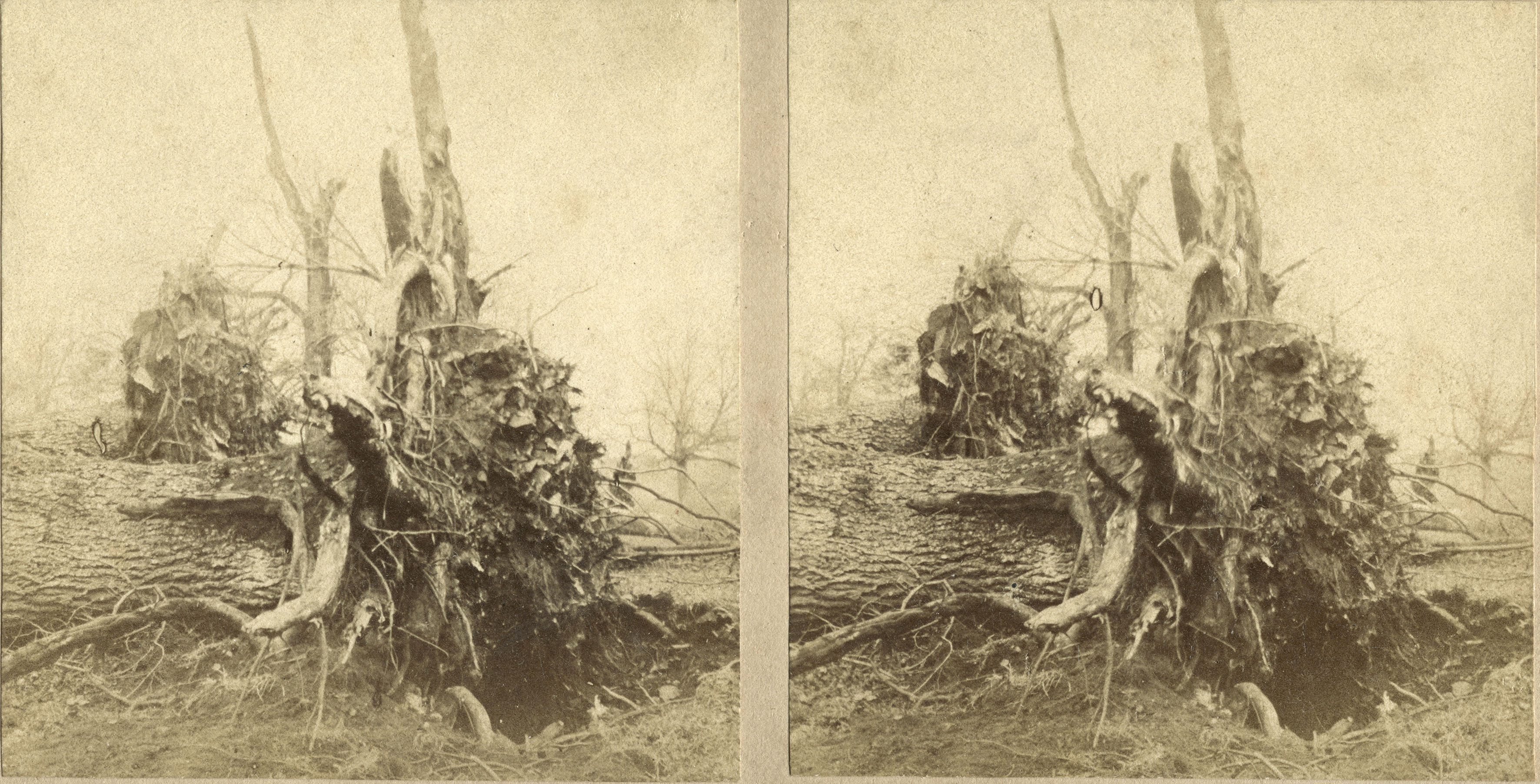
Two historic photographs (or perhaps four depending how you’d like to count) have come to us recently that mark a significant event in the history of the estate. The photos are extremely early, now thought to be the earliest photos of Kings Weston know, and are designed for use in a stereoscopic viewer; each of the two photos is taken using separate lenses set the same distance apart as the human eye; when seen through a viewer the eye sees a 3D impression of the view. Whilst the two photos on each card look the same at first glance, they are taken from fractionally different perspectives to create the effect.
One of the elms blown over on Penpole Lane on 1/11/1859. the location looks east from the current location of the Oasis Academy school.
The views focus on large a number of massive fallen trees pulled out by the roots and thrown over. On the reverse of each the location is identified as Kings Weston and dated as being from November 1859. They were taken following a violent storm that severely damaged Shirehampton and the Kings Weston estate on the first of that month. We’ve known of this event before, from newspaper articles that described the devastation, but these photos add incredible insight into the aftermath. The UK was subjected to a number of heavy storms around the same time in 1859, the most famous being the “Royal Charter” storm the week before Kings Weston’s. The Royal Charter sank off Anglesey on October the 25th with more than 400 fatalities and the loss of a substantial cargo of gold being brought from Australia. The sinking occupied journalists for days as details of the story became known, but Kings Weston would shortly join it in the national newspapers.
Three elms in a row are seen wrenched out of the ground. These trees may be on the avenue from the Circle into Penpole Wood, and the dark conifer in the distance may be either the Cedar tree at the east end, or the Wellingtonia at the west; both trees would have been young at this time.
Newspapers at the time describe the winds as arriving before dawn, sudden and ferocious, there’s even the suggestion that it was a tornado, considering the relatively localised trail of damage from Lamplighter’s, through Shirehampton, and into Kings Weston park it’s certainly a possibility. Reports suggest that in just seven minutes upwards of 300 trees brought down. They describe 20-30 trees lying on top of each other and thrown down some northwards but also eastwards. The lawns of the house were scattered with branches and timber and the whole scene became an unlikely public attraction the following day. Particular attention was made of the loss of many great old elms that lined Penpole Lane: it’s these trees that are shown in the recently discovered photos.
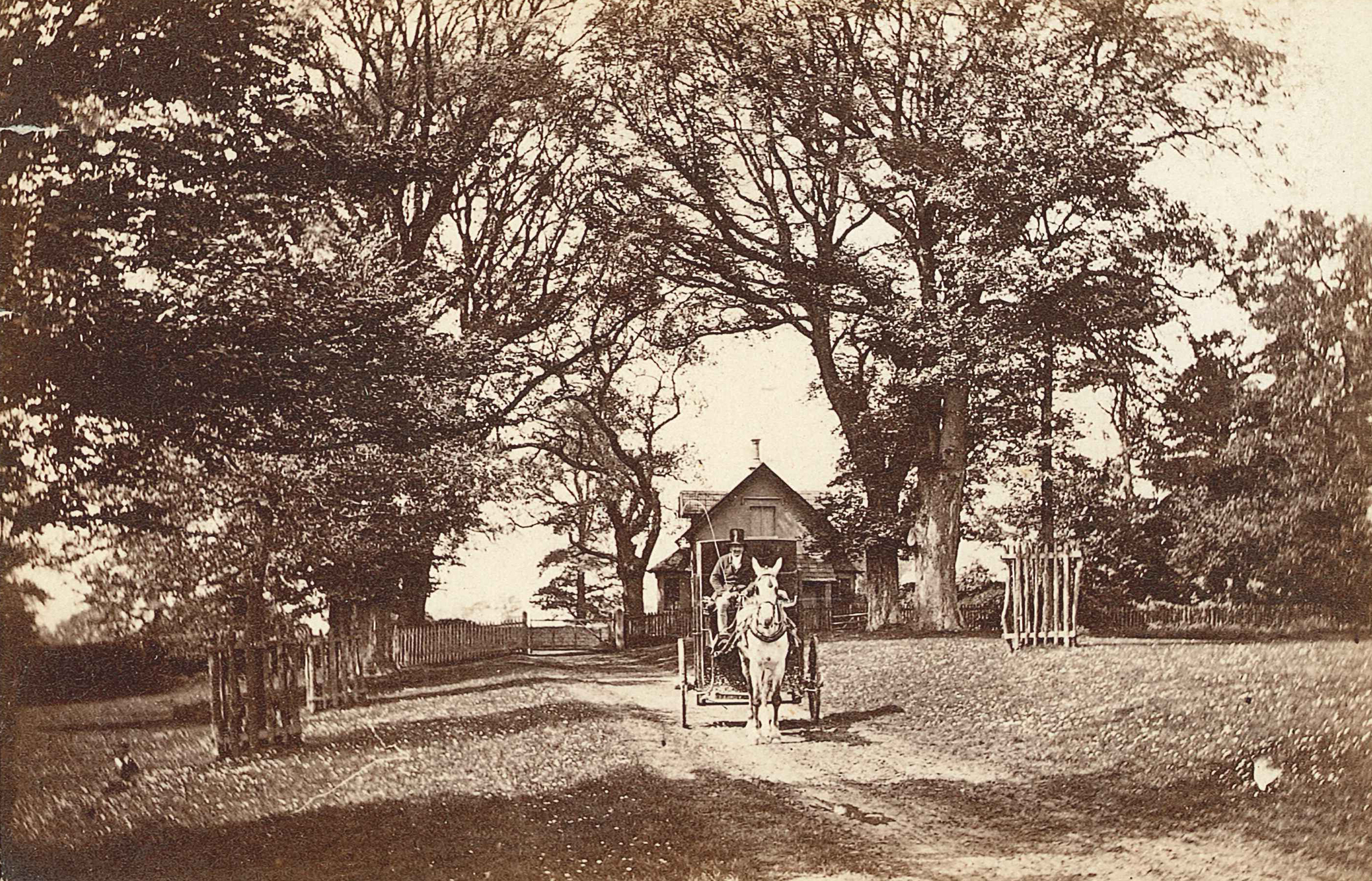
Philip William Skinner Miles, then owner of the estate, must have been faced with a huge challenge in cleaning up, and he appears to have quickly set to replanting many of the lost trees with new. A slightly later photo of Penpole Lane, from the 1860s, shows the replacement trees protected by paling fences and are already becoming well established. Opposite Penpole Lodge in this view can be seen one of the elms that survived the carnage, the branches of which are sufficiently distinctive to be recognised in the background of one of the storm photographs seen from the other side; a helpful landmark in locating the photographer’s position in 1859.
the scene on Penpole lane in around 1867, looking towards Penpole Lodge. Young trees replacing those fallen stand guarded by fences.
Thankfully, for the modern visitor, Skinner Miles chose lime trees instead of elm, or the estate would again have lost them all from Dutch Elm disease in the 1970s and 80s. Many of these lime trees can still be seen lining Penpole Lane and the avenue into Penpole Wood from the Circle.
One of the news reports detailing the course of the storm and its impact.
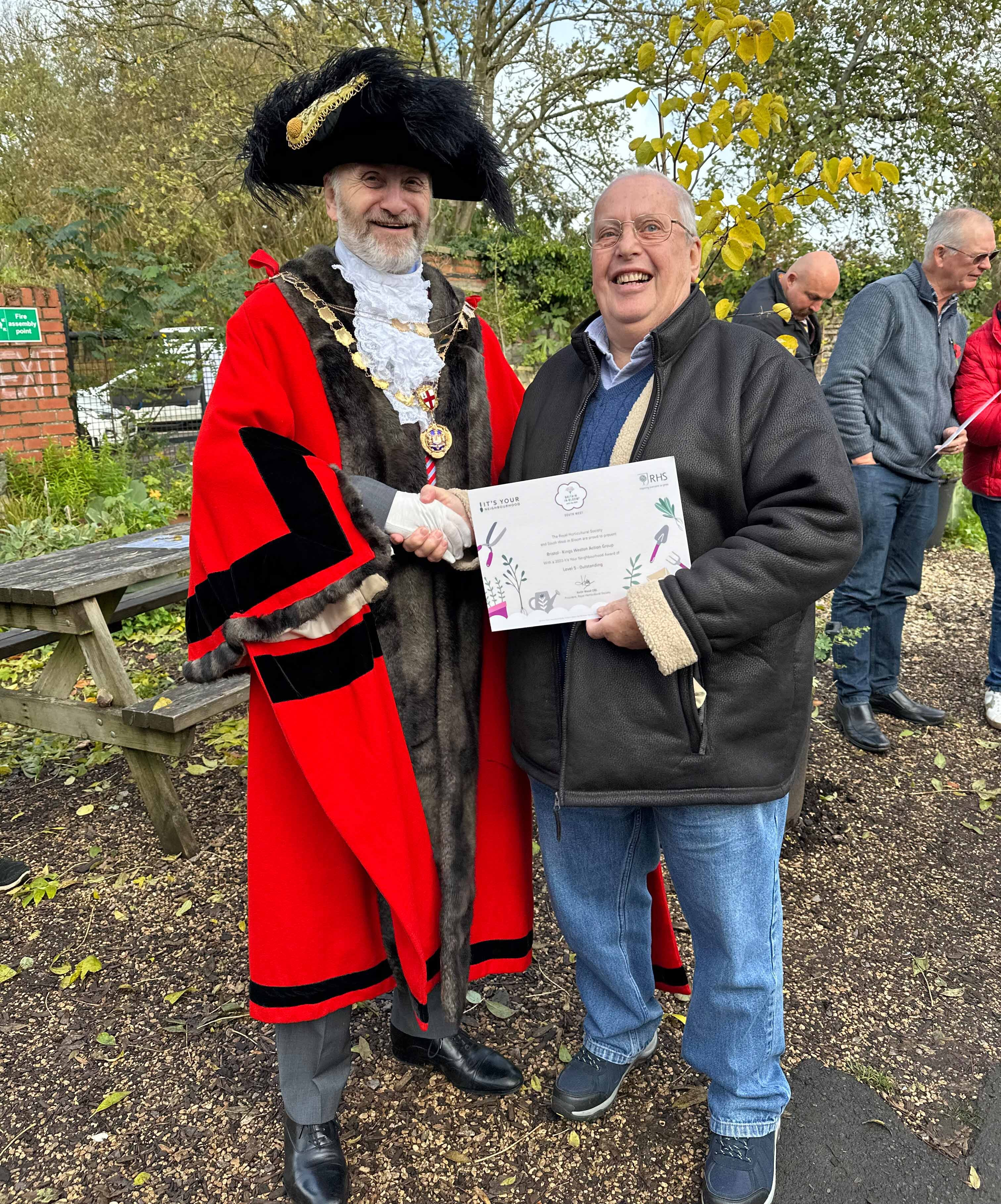
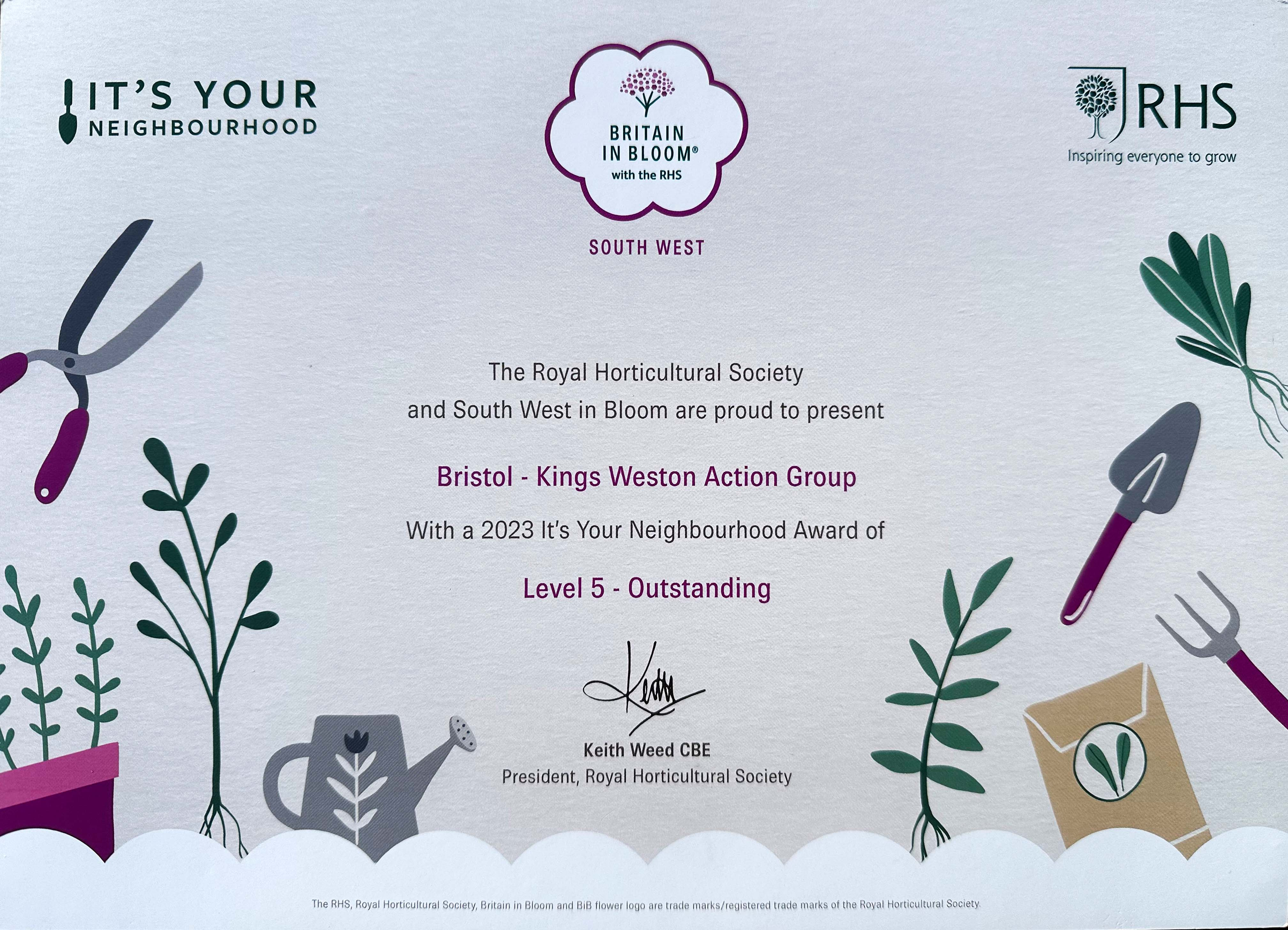
KWAG volunteer Jim Ellis receiving the certificate from Lord Mayor Steve Pearce.
A couple of KWAG’s regular volunteers recently attended a ceremony at the Ardagh on Horfield Common, to receive awards from the RHS Britain in Bloom It’s Your Neighbourhood scheme. These are held every year to celebrate local community action in greenspaces across the South West.
Earlier this year we toured one of the awards judges around the estate highlighting a lot of the volunteer action taken on the parkland as well as the establishment of the Penpole meadow, last year’s bulb planting, and our continued efforts to celebrate the historic Kings Weston estate. We were delighted that KWAG has had its efforts recognised by the RHS scheme with a Level-5 award for outstanding work. We’d like to share thanks to everyone who has come out to help over the last 12 months, and pass on that your efforts are being noticed, welcomed, and now recognised in these awards. Thank you!


