It’s always lovely to meet new volunteers, and we welcome those who turned up last month to lend a hand with keeping on top of the cherry laurel regrowth close to the Echo. It’s been eleven years since we began cutting this invasive shrub away in this area. Thanks to the Council following-through with poisoning of the stumps the growth has been seriously retarded, but eleven years is still a long time to go without any re-cutting.
Looking downhill towards Kings Weston house, an area first cleared in 2014.
Some areas had started to become quite overgrown with laurel, and there was a need for care in cutting them out. Dozens of saplings, planted by KWAG not long after we cleared, survive and have begun to thrive. It was important that none were accidentally lopped off in the process!
The target was to clear everything between the Echo and the two ponds. Most of this was achieved, but we fell slightly short for want of volunteers to help in the afternoon. Nevertheless, only small areas immediately around the pond remain to be done this month.
Looking up the slope with The Echo revealed in the distance after laurel clearance work.
One unforeseen bonus of our work has been the revealing of some of the native bulbs planted in the area as part of one of our early big Bulb Plants. Groups of Snowdrops and native daffodils were discovered cowering under the cherry laurel and bramble, hopefully now more able to survive.
Another task performed on the day was the pushing back of the cherry laurel margins alongside the boundary wall and road. We’re keen not to lose all of these and expose walkers to the traffic, but there was a good deal to cut that had begun to grow back across the path again. Unfortunately, we have an incomplete set of before-and-after photos, but we’re returning this weekend, so we’ll provide more of an update next month.
The view looking back towards the house looking down the pleasure walk leading behind the woods from the Echo.
KWAG brings volunteers up to speed on the tasks for the day.
The estate and KWAG was fortunate to host a team-building event by officers of Bristol City Council Development Management team on Wednesday 25th October. We’d managed to arrange with Kingsweston School for a group of 25 volunteers to access the area of the Georgian walled gardens around the lily pond on Napier Miles Road as the latest in our campaign to stem the tide of neglect and restore the much-loved and historic site.
The work overseen by KWAG focussed on the three strips of garden surrounding the pond, the removal of the dead box hedging, digging-up of brambles, and the felling of self-seeded saplings and shrubs. The formal box hedges succumbed last year to an onslaught of box moth caterpillar that ravaged Bristol. Here it left just a single bush alive, and that just barely. The brambles and saplings have taken advantage of the lack of maintenance since the school returned the pond area to Council Property department.
The south walk along the pond before and after the day’s events.
We were lucky enough to take advantage of the west lodge at the pond for bag storage as the team were briefed on the tasks for the day and health and safety. It was impressive, the way that the volunteers engaged with the work and threw themselves into it. Despite an unpromising weather forecast, the rain held off until the dying minutes of the event before 4pm and we even enjoyed some sun.
Tired Council volunteers pose at the end of the day outside the lodge.
We were lucky to have one of the city ecologists and tree officers as part of the team who were able to advise us on the work. The ecologist was particularly in demand when digging disturbed dozens of Common Newts and other amphibians settling down amongst the roots. These were relocated to safe areas around the pond.
Huge inroads were made on clearance, massive progress in restoring the area. Whilst the job wasn’t completed in its entirely, the magnitude of the job was enormous and what was achieved was epic in scale. We are extremely grateful to all the Council officers who turned out for the event and made such an impact. Despite the wet finish everyone enjoyed the event and stuck with it until the very end. The space that’s been revealed is now a blank canvas to re-plan the gardens, and buys precious time for KWAG to plan a viable new future. Thanks too to Kingsweston School for hosting us, and parks and other departments of the Council for enabling the event.
Similar views of the west side of the lilypond in 1898, and before and after recent volunteer work. The pond edge is again discernible and brambles threatening the lodge have been cut.
…As a postscript, KWAG returned to make some investigations of the pond and have managed to clear some of the saplings alongside the road so visitors can glimpse progress on the garden areas beyond.
Some clearance at the lilypond has allowed us to find the waterline and judge the extent of the tree growth.
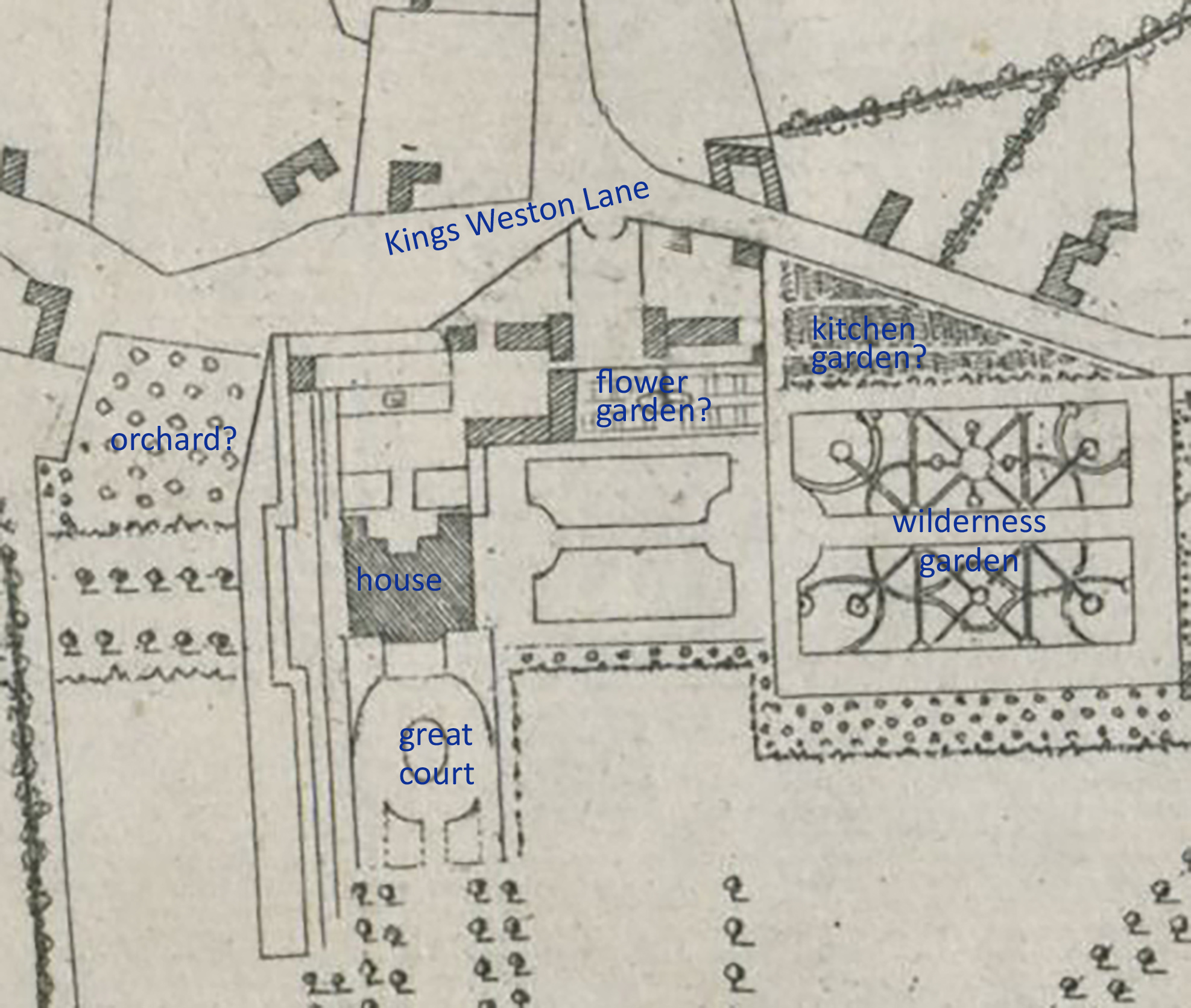
With a renewed focus on the area, it’s worth looking again at the history of the View Garden, once referred to as “the gem of the whole garden”, and lilypond to understand their significance. There’s enough map evidence provided by two important estate surveys of 1720 and 1772 to appreciate the colossal scale of the works undertaken from 1763 to transform the area into the walled garden and stable complex that survives today as a series of Grade II-Star listed buildings split across Napier Mile Road. To help understanding and appreciation we’ve created a short series of sketch views of the area at key moments in their development. Each image has a numbered key with the individual points described below…
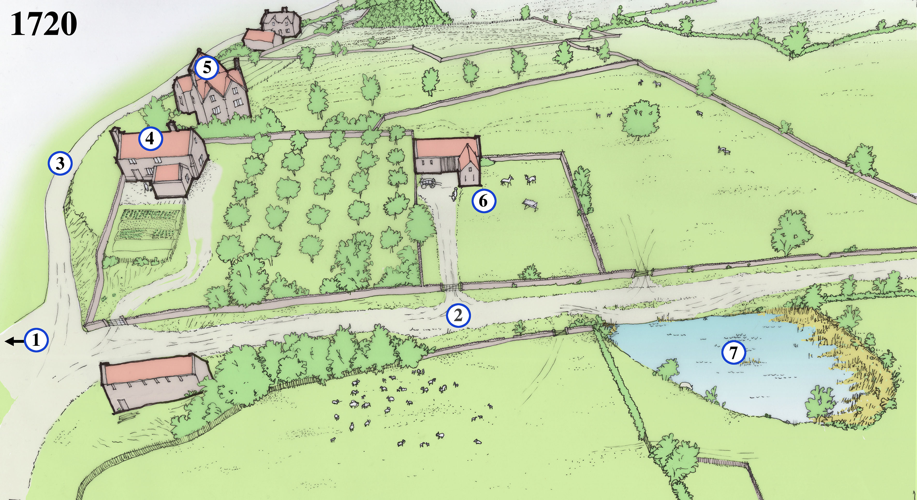
1720
Halett’s estate plan of 1720 is an important record of Kings Weston just as the mansion had been completed, and before new garden works were begun. Although broadly accurate it provides scant information on the appearance and use of the area east of the main house. A later engraving gives a bit of detail, but the reconstruction here can only be described as speculative despite being based on these sources. Our reconstruction depicts an agricultural landscape with fields, orchards, and gardens separated be dry stone walls and hedges, with a few scattered traditional vernacular styled buildings. One of these was perhaps the source of a carved window stone, later built into the glasshouse wall in the 1770s.
1. The road entrance to Kings Weston house approaches from the east as it does today. The present gatehouse and wall are Victorian and of 1903, and it’s not clear what the gates would have looked like at this time.
2. The present Napier Miles Road is a rural track leading from Kings Weston House to Henbury, and the parish church there.
3. Kings Weston Lane is another agricultural track, leading to a few scattered cottages and farms. The lane passes through an ancient hollow-way where centuries of water have washed off the hill and created a gully. Several gullies like this are distributed along the escarpment edge.
4. A number of houses occupy plots of land to the east of Kings Weston house. Most will have been for labourers tied to the estate. This house was on a roughly east-west alignment, and possibly reused the manor’s medieval chapel that would have fallen out of use at the Reformation. Another medieval chapel survived as a cottage in nearby Lawrence Weston until the mid 20th century.
5. A larger house stands above Kings Weston Lane, uncomfortably built into the steeply sloping land that descends towards the north. From its size it’s likely to be a higher status house than those around it. Could it have been an earlier site of the manor, before the current site was established in the Tudor period? A fragment of stone salvaged from the glasshouse wall was recorded by us in 2016.
6. A smaller building in a small plot in this location may have been a barn or other agricultural structure.
7. Shown on the 1720 plan is a large natural pond to the south of the lane to Henbury. This ill have provided a useful resource for the farms, and likely produced ice in the winter for the earlier ice house behind the mansion.
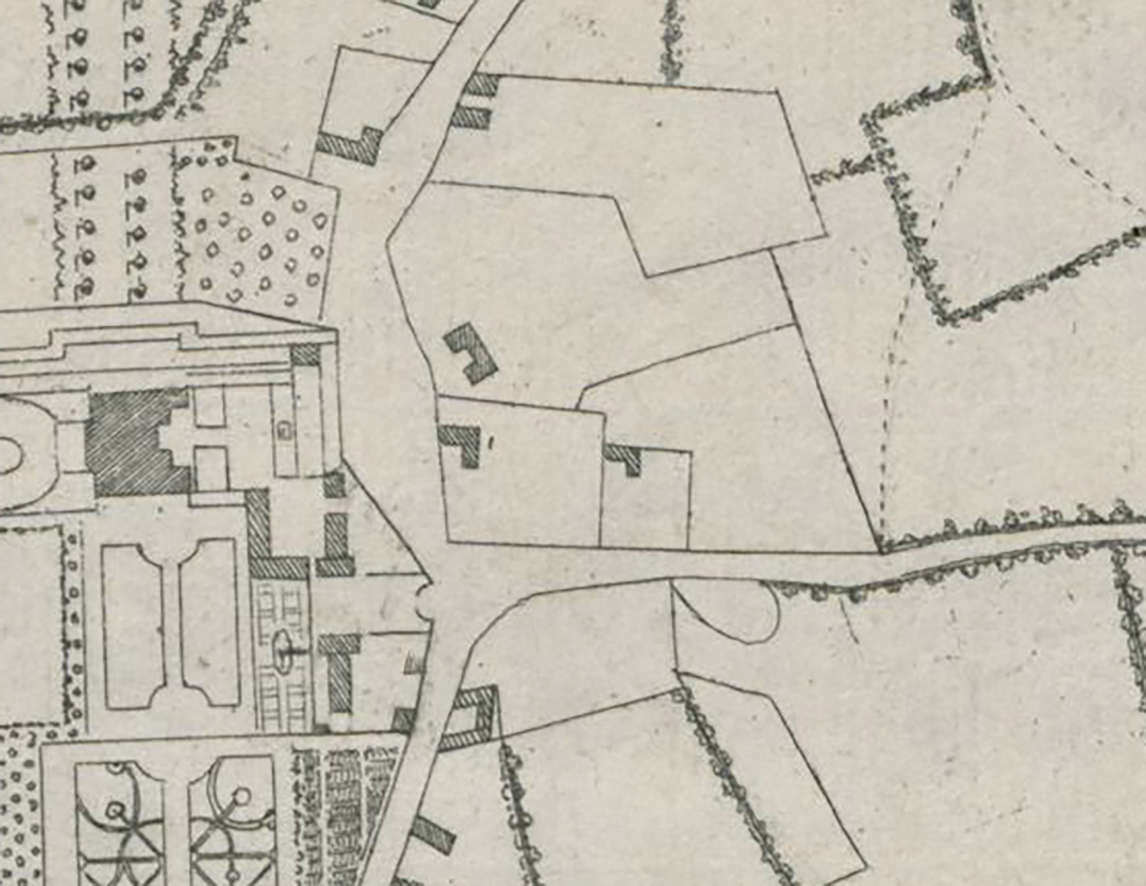
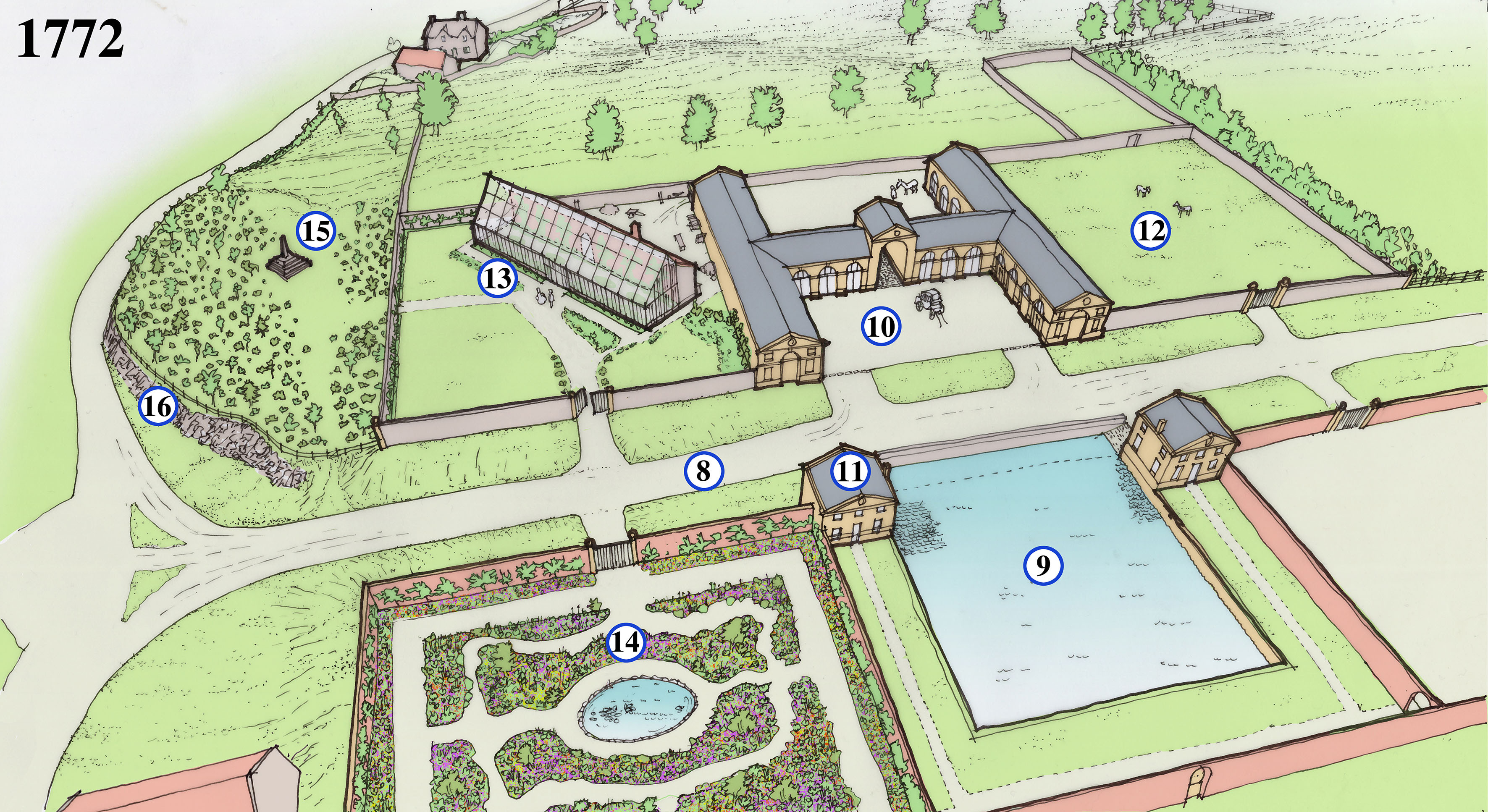
1772
Isaac Taylor’s comprehensive estate survey was undertaken between 1771 and 1772 and includes a number of radical changes east of the house, a striking transformation from rural backwater to thriving estate hub. There are, in fact, two maps of the area drawn by Taylor, each showing slightly different features, perhaps finished at slightly different times. Both show how the old houses and boundaries were largely erased. From 1763 onwards the architect Robert Mylne enacted the third Edward Southwell’s ambition to clear away all the old stables and service buildings from beside Kings Weston house and extend the landscaped parkland to fill their space. Together, architect and client instead created a new set of buildings set in a series of rectangular walled compartments on a grid plan, providing an ambitious integrated design accommodating key estate functions, various gardens, glasshouses, and an impressive carriage house and stables complex. This was all to serve the main house with produce and flowers and service the estate’s transport needs.
8. The lane to Henbury has been realigned to become a broad straight road with grassy verges either side. The new road is designed to have a visual impact when viewed from the gates to Kings Weston house from the west.
9. The natural pond is formalised into a square pond which could be stocked with fish for the kitchen as well as providing water for the gardens and stables. Ice would be collected here in the winter for storage in the icehouse. Ramps and a platform below water level are designed to wet carriage wheels to prevent them from shrinking in hot weather and losing their metal rims.
10. The centrepiece of the new complex is the grand and formal carriage houses, with stables in the wings beyond the archway.
11. Matching the stable block in style are two lodges built framing the pond; One provides a gardener’s cottage and the other a seed house.
12. Paddocks for horses are probably intended for the north-eastern quarter of the complex.
13. Set in its own compartment and angled to maximise exposure to the sun, the glasshouse at Kings Weston and was one of the largest in the country was built in about 1771. A tall masonry wall at the back incorporated a hidden hot air heating system powered by a furnace at the back. The glasshouse quickly became a focus for Sophie Southwell’s interest in horticulture and where she nurtured her interest in growing exotic plants and flowers. It became a much-remarked feature of the estate during the 18th Century.
14. Produce gardens were kept to the southern compartments behind the pond and this walled area. This area with better access to Kings Weston house was a flower garden, laid out on a broadly regular plan but with eccentric windy paths adding interest. Flowers would have been grown to supply the house with attractive displays and perfumed blooms, but also offered a more intimate garden experience to the landscaped parkland then laid out around the mansion. An oval pond at the centre would have ben used to help watering and create an attractive centrepiece to the garden.
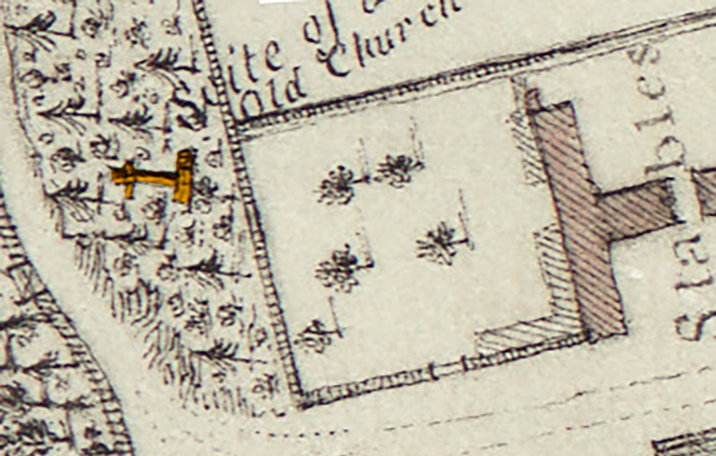
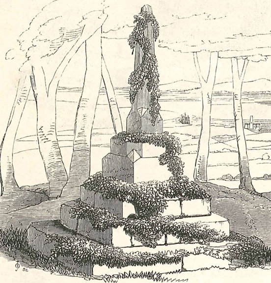
15. One plan of this date shows a cross here and describes a “site of an old church”. Later maps show “Bewy’s Cross” standing here. In 1720 the site was that of a building, so it’s unlikely that the cross was there at the time. It’s speculated that an ancient cross at the mouth of the Avon was relocated to Kings Weston as a garden ornament, though perhaps intended to mark the site of the old chapel. What evidence existed to suggest the church, more accurately chapel, stood here is unknown and lost when the standing buildings were demolished.
16. To create a regular new road to the stables and improve the way down the hill parts of the hill are quarried out and pushed back to leave rugged rocky cliffs against the road. New plantations are planted above them to naturalise their appearance and as a setting for the cross.
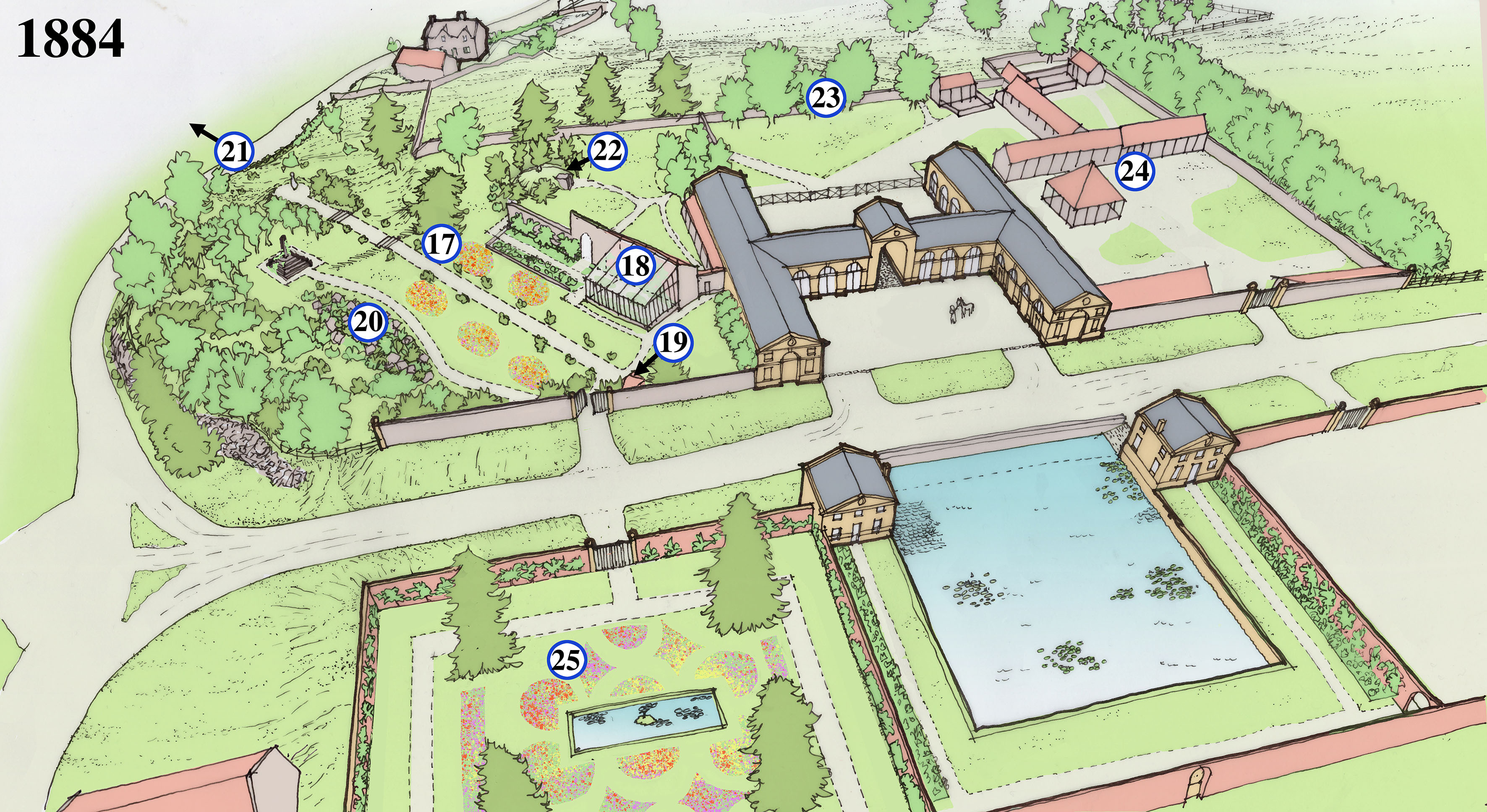
1884
The rigid Georgian plan and ambitious scale of the walled garden complex provided well for Kings Weston for over a century, with little change. The ownership of the estate had passed from the Southwell to the wealthy Miles family. Changing fashions in garden design and use and a greater demand for service buildings saw some blurring of the rigid boundaries and expansion into the surrounding landscape. The biggest change was the creation of the View Garden, probably laid out in the 1860s. The name is first recorded in 1916 when it was described as “the gem of the whole garden” at Kings Weston.
17. By the 1840s the wall of the north-east compartment is thrown down and the glasshouse and cross brought into a single garden space. About 20 years later a long axial path is laid out on the same alignment as the glasshouse, with two sets of stone steps. Fragments of these survive today. The lawns either side of the path were probably set out with ornamental flower beds. The new garden is christened the “View Garden”.
18. The Georgian glass house is passed its prime and has been rebuilt on a less ambitious scale against its original. The parts no longer covered are turned into more planting beds.
19. A covered garden seat or alcove is built at the head of the axial path, just to one side of the entrance gate, and from which to enjoy aligned views through the gardens. Yews and box trees are planted to lead the visitor along the paths and line the back of the main garden wall.
20. Another path is laid out on a more picturesque winding course, taking in a large new rockery on its way to a small clearing around the medieval cross. It may have been whilst creating the rockery or the axial path that foundations of a building were uncovered again in the 1860s and again thought to be the chapel ruins. In 1868 the cross was described and illustrated as covered in ivy, perhaps planted for picturesque affect? The view through the trees here certainly had eye-catching views to the Severn.
21. The axial path culminated in a circular viewing platform elevated above the slope of the hill. It enjoyed distant views across the Severn and Avon towards Portishead and Wales beyond, giving the View Garden its name.
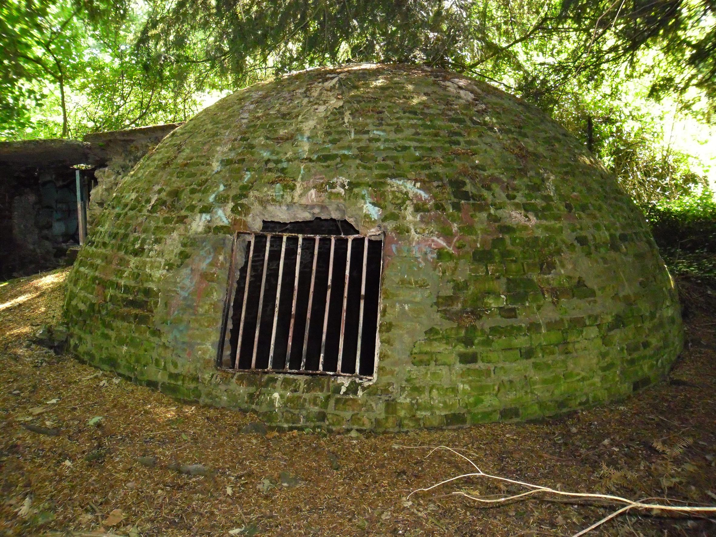
22. The old icehouse behind Kings Weston house was done away with, probably in the mid-Victorian era, and relocated to behind the old glasshouse. It was covered in earth to provide added insulation and planted around with yew trees to protect it from the sun. One yew tree was planted at the very summit of the domed icehouse and remained there until it finally fell in the 1980s, pulling the earth covering with it.
23. The original Georgian rear wall was pushed north with the land built up to form a flat platform, falling away with a steep embankment beyond. The additional space accommodated the icehouse and more paddock and building space.
24. Fox hunting had become a popular recreation activity for the Miles family and more buildings were needed to stable horses and provide storage and dog kennels. These were added to the north of the stables. A woodyard and sawmill were also added in this area.
25. The flower garden had become more formal and less focussed on providing for the house. It’s dominated by four conifers planted around a now-rectangular ornamental pond. Like the View Garden, the lawns were likely planted with floral displays of seasonal bedding plants in the Victorian fashion. This garden would shortly be transformed again, with the conifers felled and a more informal pond and rockery.
We’re grateful to Shirehampton resident and long-time supporter of KWAG, David Pickering, for his donation of a small set of photos to add to our permanent collection.
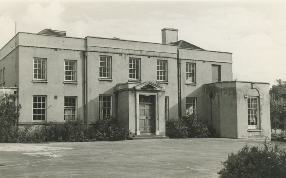
The photos are a record of the House in the Garden, and the Georgian walled gardens in which it sits. The original walled gardens were begun in around 1762, but when the last private owner of Kings Weston house, Philip Napier Miles, died in 1935 it became redundant for its original purpose. Here, in 1937, the widowed Sybil Napier Miles decided to build a smaller house for herself where she lived until her death in 1948.
The House in the Garden was built in 1938 for Sybil Napier Miles after the death of her husband.
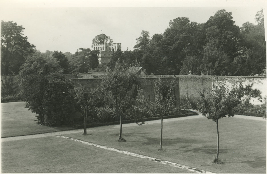
She was a keen gardener and turned the flower and produce gardens within the historic walls over to a private garden for her new home, removing many greenhouses but retaining certain elements she thought useful or attractive. The gardens were already established by 1940, when they were opened to the public to raise funds for the Queen’s Institute for District Nursing.
the view of Kings Weston House across the walled gardens from an upstairs window in the House in the Garden .
the view from the walled gardens across the lilypond towards the old stables on Napier Miles Road.
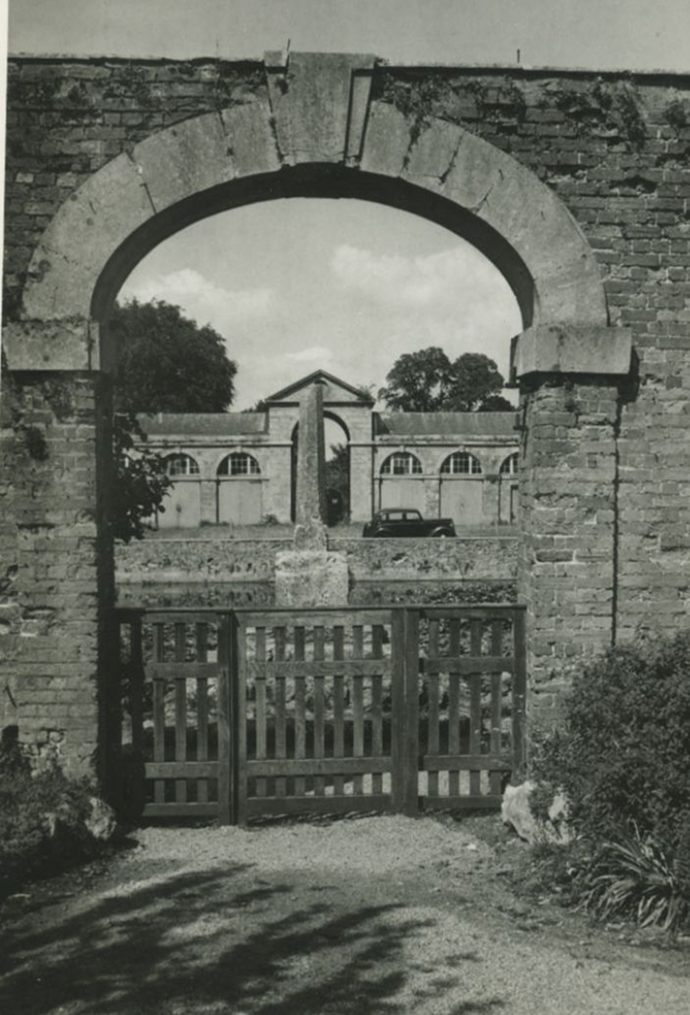
The exact date and circumstances of these photos taken by an official Western Daily Press and Bristol Observer isn’t known. The house and grounds were purchased in 1948 by the City Council to form a new primary school before new premises in Lawrence Weston were complete. They do not appear in the sales literature of that time, and there appear to be school sports court markings painted on the front drive, narrowing it down further. One source suggests 1954, which may be correct, as the condition of the old stables seen through the arch is better than when it’s next recorded, derelict, four years later. Regardless of when they were taken, they are a beautiful record of the house not long after it ceased as a private residence.
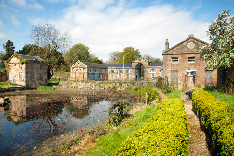
The Lilypond and Georgian Lodges have now been declared surplus to the needs of Kingsweston Special School, and we hope now to be able to discuss restoration with the Council more directly
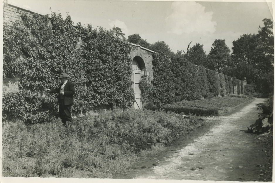
Fruit trees trained up the back wall of the walled gardens, with the beds gone to seed.
Way back in 2013 KWAG made contact with the John Russell, 27th Baron de Clifford, ancestor of the Southwell family. Initially we were most keen to record a number of paintings the family possessed, those which once hung at Kings Weston before the last member of the direct lineage died in 1832, but the family were eager to show us a large collection of documents too. We were delighted to be able to arrange for these to be transferred to Bristol Archives on their behalf, and were privileged to be able to review them before they were added to the city’s collections.
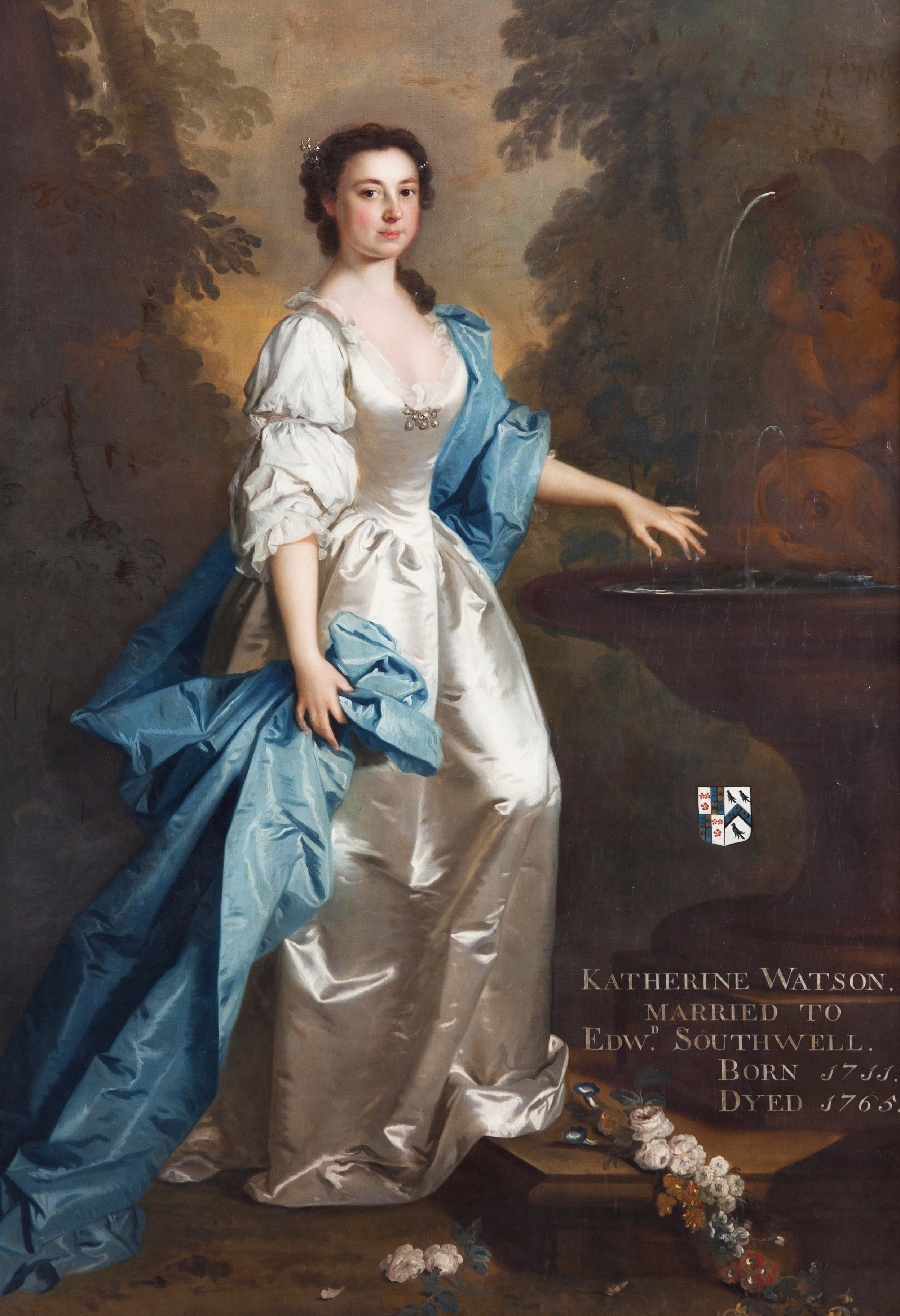
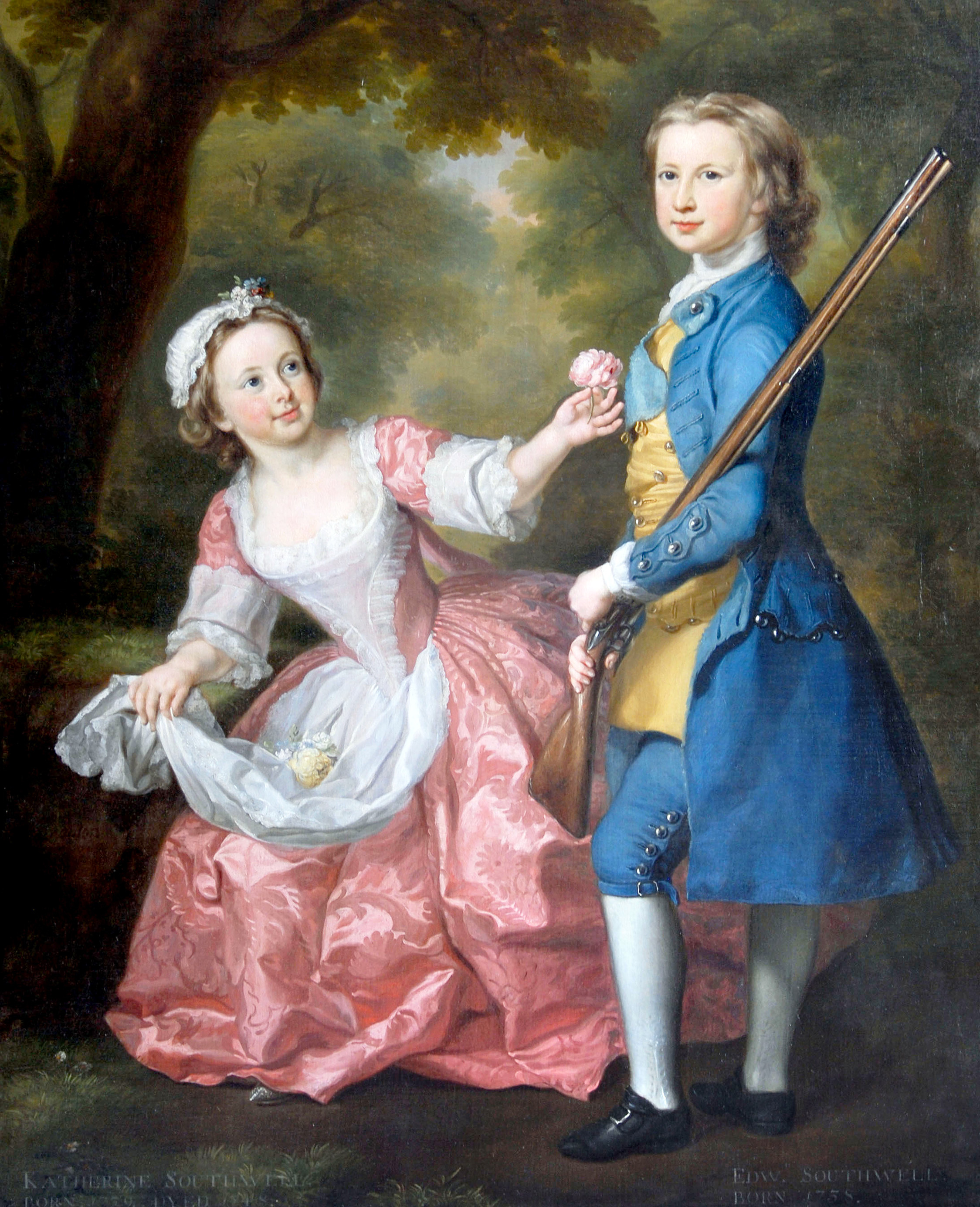
There was a much of interest to Kings Weston, perhaps nothing more so than a fascinating series of letters written from Katherine Southwell to her son, Edward Southwell, whom she affectionately called Ned, the third of the family to carry that name at Kings Weston. We know Katherine today through a glorious portrait of her that still hangs at Kings Weston house. Painted by Allan Ramsay in 1740, it faces her husband across the hall where they were installed there by her son shortly after her death in 1765; indeed the whole of the portrait gallery may have been designed as much to memorialise her as the rest of the family.
Katherine Southwell by Allan Ramsay, 1740. It hangs in the Saloon at Kings Weston opposite that of her husband, Ned’s father.
Katherine and Ned’s father, also Edward, appear to have had difficulty in conceiving, the young heir not being born until nine years into their marriage. Another child, a daughter also named Katherine, died but ten years old, and perhaps a second son may never have survived infancy. Edward Senior died in 1755 leaving his wife and son alone. It is perhaps in this context that Katherine’s affections for her surviving son were so great.
The letters between mother and son begin in 1749, but climax after 1758, the year that Ned left for the Grand Tour of Europe, an essential component in the life of any young man of means at the time. Ned, then aged 20, left behind his 48 year old mother with few friends and family members around her. The parting was keenly felt by her, and the ensuing stream of letters that followed his departure exudes that affection and care felt for her son, but also the eagerness for him to improve himself and kindle ambition.
Throughout Ned’s three year tour of Europe his mother sent letters, each one was carefully preserved by Edward on his travels and returned with him to the country, testament that his affection matched that of his mother. The majority survive today, though sadly there are notable gaps, where batches of correspondence appear to have been lost to time. It’s also unfortunate that we don’t have a reciprocal collection of Edward’s writings to make full sense of Katherine’s letters, but this doesn’t dim their colourful and engaging insight into mid-18th Century life. In them she updates her son on the global political situation, intermixed with “tittle-tattle” and gossip, encouraging words, and descriptions of her own exploits. Her search for a suitable new home to act as a Dower house is also a regular feature of her letters. Moreover, the letters are an incredible insight into Kings Weston, the gardens and staff employed there, and the comings and goings of tenants, neighbours, and livestock long-known to them both.
Ned Southwell in the only known portrait of him with his sister Katherine. The painting must date to before 1748, when his sister died. He would have been under 11 years old.
In Ned’s absence, Katherine spent time at Kings Weston, working with the head gardener, Gould, and the estate manager, Nicholls, carrying out her son’s instructions. Sometimes she is at the centre of the action, actively out in all weathers assisting in planting trees, and other times an observer, sending on vivid descriptions of the flourishing parkland. She wrote:
“I got hither to dinner yesterday, and was lucky in having good weather, and took the advantage of a very fine afternoon, to visit your plantations in the quarries, who thrive very well and are very clean, as is the garden; nay even the park is more free from nettles than usual; a prodigious quantity of grass and bullocks and sheep fatting on it; your colt frisking about very gay and for what I know very fine ones; ………I live on the hope of once more enjoying you all together and let the intermediate space run on as it can.” Kingsweston, 27 Sept. 1758.
The gardens around Kings Weston house in 1720, before their redesign.
And soon after: “Having no letter of’ yours, my dear Ned to answer, and having had no visitor but Mr, Berrow this can bring you no news but of the mute and vegetable part of the creation. To begin then your serpentine plantation at the bottom of Penpole looks much less like a snake than it used to do, the trees in general are flourishing and, the laurels almost cover the wall; it is extremely clean and has been twice sow’d this year, once with turnips and once with fetches.
The quarries have lost but few trees, but the hares and the lambs have crept under the rails and nibbled some, out. I find they took good care to keep them out as soon as they perceived it for ‘tis very little damage that is done.
The old kitchen garden is transformed into a nursery, but Gould cou’d not entirely part with the sparrowgrass (asparagus) beds, so has planted only between them, but the want’ of room this year will force him to quit his beloved.
There’s a fine parcel of young things of last year’s sowing in the flower garden, viz beach, swamp oak, Weymouth pines, cyprus, holly, laurel and some larch.
Now for my own particular friend the tulip trees that were removed are in health the arbutus are full of fruit and the two small magnolias are alive, but, alas, the great one is dead but what is still a greater misfortune to me, some Dutch sailors stole Jewel (a horse) but the day before I came.” Kingsweston, 1 Oct. 1758.
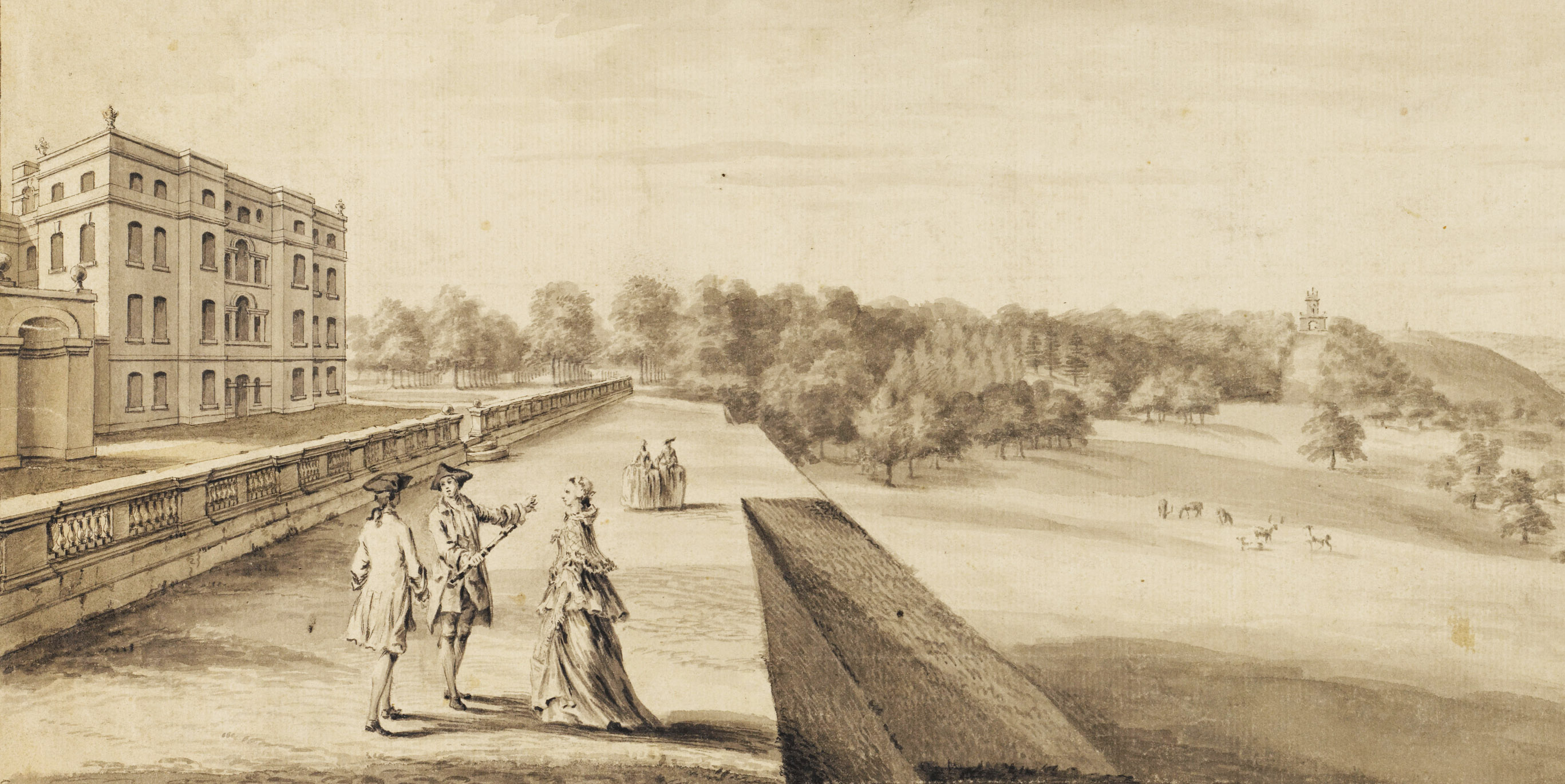
Kings Weston in about 1763, with some of the plantations below Penpole Point that Katherine mentions, and shortly after the demolition of the walls of the Great Court in front of the house. (Sir John Soane’s Museum)
Throughout his time away, Ned was replanning his estate. Katherine writes frequently about floor plans and elevations of the house being sent out to him in Europe with her letters; evidently there were plans being sent back to her and Nicholls too, and schemes which she intimates were significant in ambition. A plan for firing bricks and setting out new kitchen gardens was already in train in 1758. These plans would finally come to fruition after 1762, with the stables and walled garden complex on modern Napier Miles Road being begun; indeed, brick was made extensive use of in these walls.
“Gould advises you to make bricks for the kitchen garden wall; he says there’s earth fit for it, and ‘twill save a great deal, for they are very dear here; send me word if I shall begin; the earth must be dug six months before ’tis worked” (Kingsweston, 1 Nov. 1758)
And later:
“My dear Ned, I have sent you by Mr. Gaussin, Gould’s plan for the house and garden; l don’t imagine ‘tis quite the design you will follow, but as the ground is regularly measured and marked, I hope ‘twill give you some amusement.”
“…I come now to yours of 30 Dec. I have sent you, Gould’s plan, it is not so extensive as your: scheme, tho’ it does take in some of the road.” (Spring Gardens) 23 Jan. 1759.
“I am in a fright about the bricks; for as that was not Nicholls’s own proposal, I find he does not approve of it, and make great puzzling and difficulties and works, so unintelligibly about it, that I don’t know what he is doing.”
In this letter Katherine implies that the line of a road, probably part of Kingsweston Lane, is included. That may have been the southern end that now faces onto the side of Kings Weston inn cottages, but before then looks from maps to have been aligned further to the west. Katherine eventually settled on a house at Westhorpe, Little Marlow, which she figured would be convenient for her son to drop in on between the family’s town house at Spring gardens and Kings Weston. Most of the letters after 1760 are written from her retirement there.
Westhorpe House, Little Marlow, Buckinghamshire.
From 1759 Katherine leased the place as her Dower house. She agreed to buy the furniture already there, and a boat that she fancied Ned would enjoy using in the park’s lake. After his return to England in 1761, Ned quickly took works on the estate in hand. Unlike his father, who had been created Secretary of State for the Kingdom of Ireland by entail, he had no position in court or government, and sought to rebrand Kings Weston as a political powerhouse. With an ambition for a seat in Parliament, he set about modernising house and grounds as a statement of intent, as many of his peers had also done. His first task was to move the collection of old stables and kitchen gardens from a cramped position next to the house. Employing the architect Robert Mylne, a gentleman whom he’s believed to have met in Rome during the Tour, Ned began work quickly. It is perhaps not a surprise that he turned to his mother to lay the literal and metaphorical foundation of this political ambition.
“You are very ‘obliging in seeming to think what I have done at Kingsweston prospers; alas, ’twas so very little, that to me ‘tis not perceptible; I shou’d very gladly lay the first stone of any building projected by you for I have a great propensity to like your designs.” 3 May, 1762.
She appears to have had concerns over the height to which the garden walls were to be carried for she wrote later the same year:
“I honour your spirit and resolution, that has carried your walls up against all your ministry, but know that from this time forward you’ll be charged with every blight that falls on your trees and must never complain of unripe fruit, or backward pease, without being told you wou’d have the walls so high no sun can come into your garden.” Westhorpe, 3 Sept. 1762
The stables and walled garden begun by Ned immediately on his return from his Grand Tour. the garden walls make extensive use of the brick he was intent on firing from his own resources.
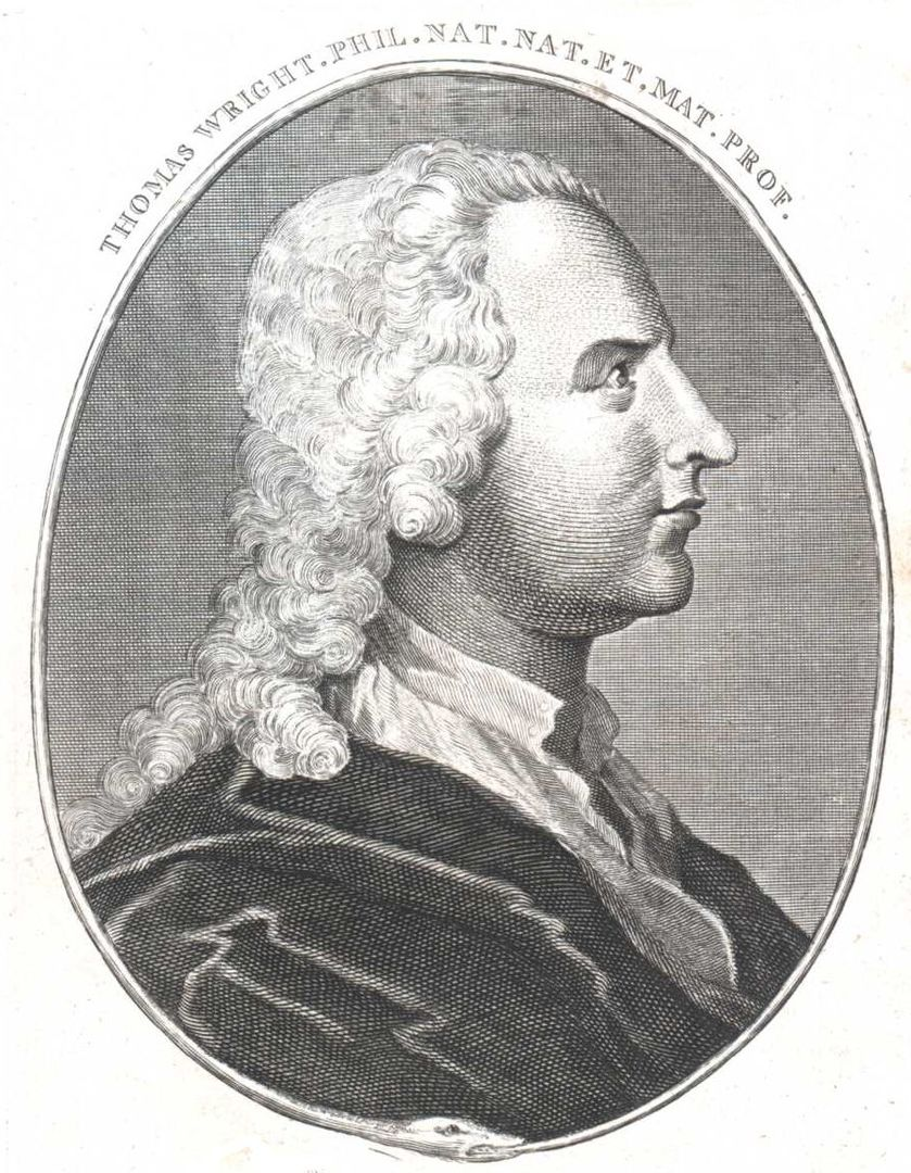
We had long believed that the landscape gardener Thomas Wright, the “Wizard of Durham” had worked at Kings Weston, but it is only through Katherine’s letters that this has been confirmed. Wright had been working nearby at Stoke Park on the other side of Bristol, but also for the Duke of Beaufort at Badminton. That he worked at Kings Weston too explains some of the landscaping introduced during the 1760s and the celebration of the quarries in Penpole Wood as rustic garden features.
“… I am glad you are agreeably detained and that Mr. Wright and you have not quarrelled. He must be a very odd creature for he has refused very advantageous offers from Lord Halifax to go with him to Ireland and prefers liberty tho’ joined to poverty. I don’t blame him for I think I shou’d do the same. Saturday, 11 April. 1761 (Westhorpe?)
“I wish I could see your new designs with Wright but you will tell them me and they will shew better when executed” Tuesday 8 April 1761 (Westhorpe?)
Wright probably advised on the deformalisation of the Kings Weston landscape, the thinning of avenues and grandiose architectural features in favour of a naturalistic pastoral landscape. It may have been his suggestion that resulted in the pulling down of the Great Court in front of the house. An important note from Katherine records the year this was planned:
“You are a lucky man, my dear Ned, to have nothing, to find fault with on your return home. I hope your perturbed spirit is at rest now, my dear Irishman and that you no longer overlook your works after ‘tis dark and before it is light. I shall find great fault when I come if the return wall to the parlour window is not down.” Westhorpe, 22 Aug. 1762
Thomas Wright, 1711-1786 Wizard of Durham, architect, astronomer, mathematician, and landscape gardener.
Katherine writes in an incredibly genuine and engaging manner, making her letters a joy to read. They are sometimes candid and amusing, whilst her campaign to resurrect the de Clifford Baronetcy in favour her son shows her as determined and intellectual. The total collection of around 200 letters is a vast trove of fascinating details on mid-Eighteenth Century life. We are only now transcribing the collection, possibly for future publication. The original letters are available free to view in Bristol Archives: Letters from Mrs Southwell to her son Edward (bristol.gov.uk)
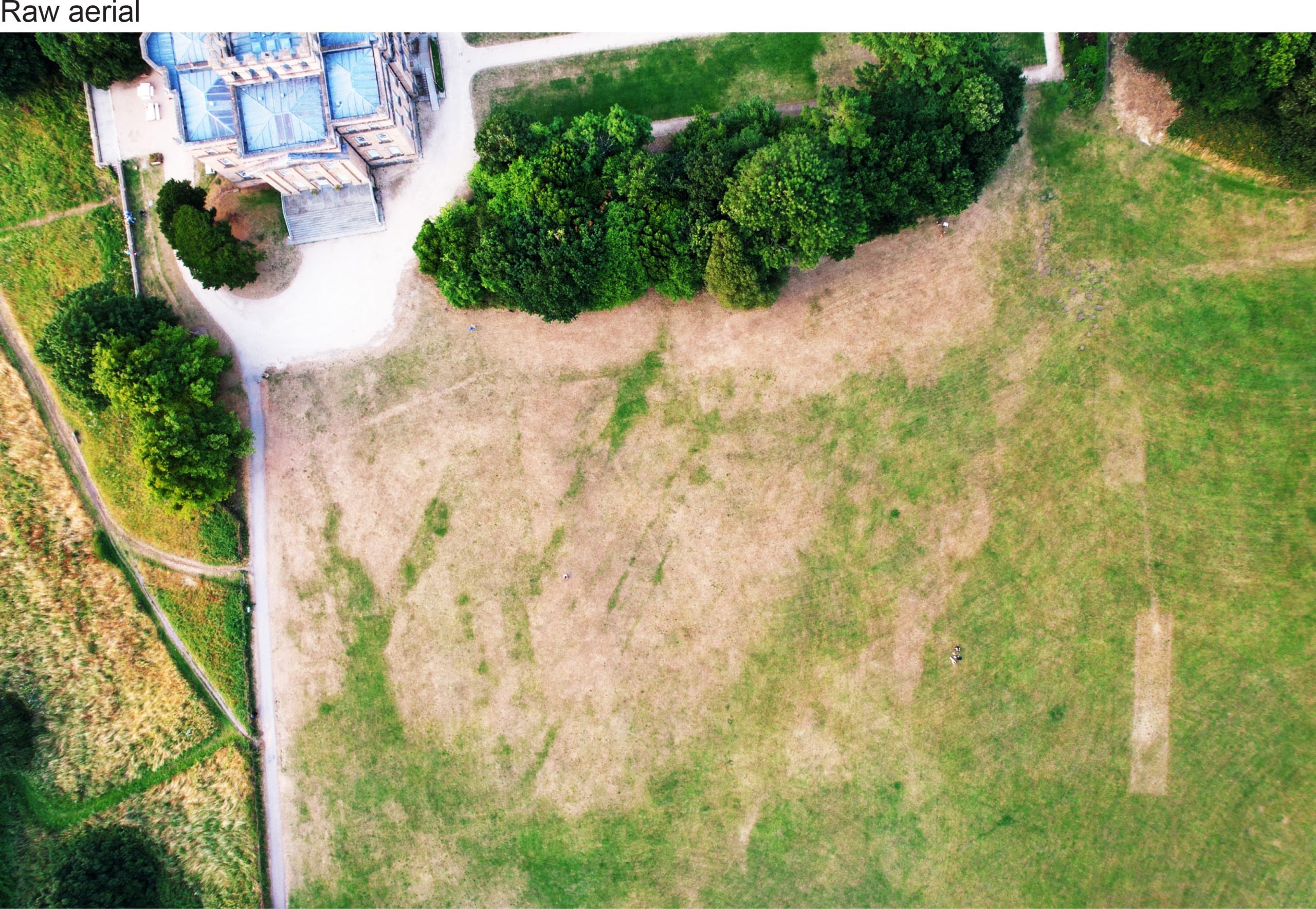
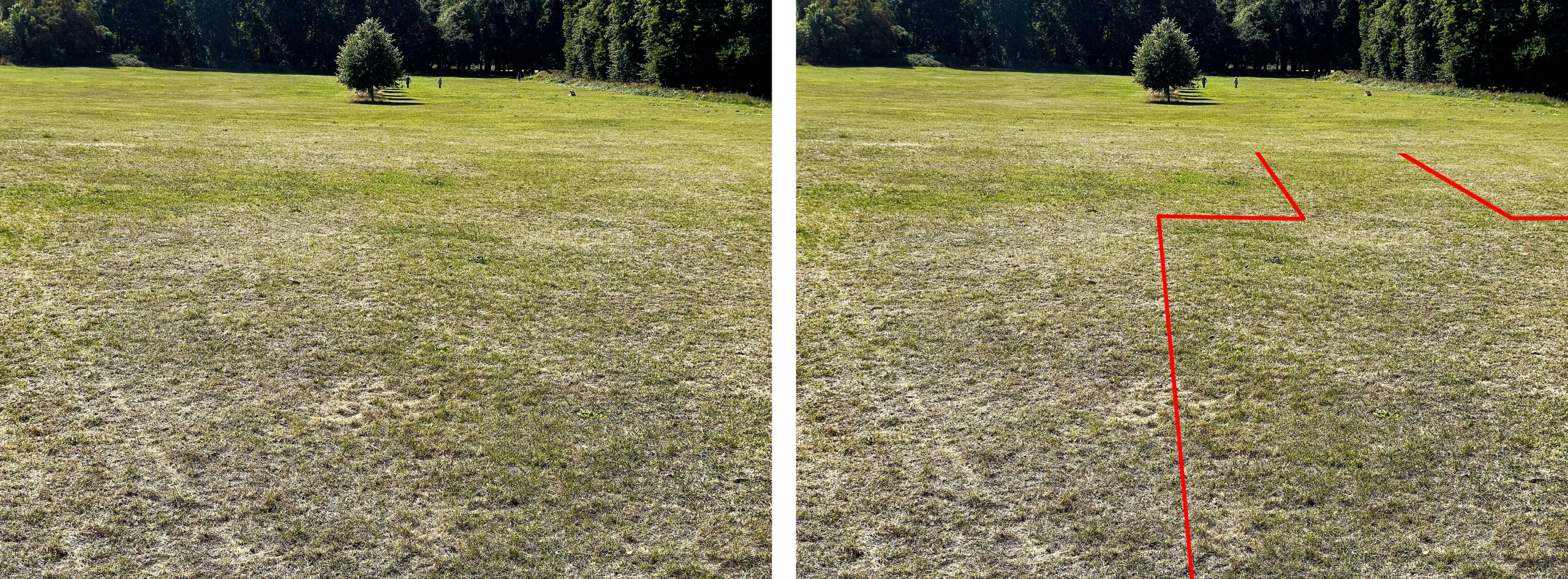
We reported last month on the parch parks that had become visible in the lawns around the house in the hot weather. We’re really grateful to Matt Ford, a drone enthusiast, who remembered us asking about this a couple of years ago, and captured a couple of great images looking down on the area. These have revealed much more about what we could see on the ground, and have also helped correct some of the archaeological survey work we’d undertaken in previous years.
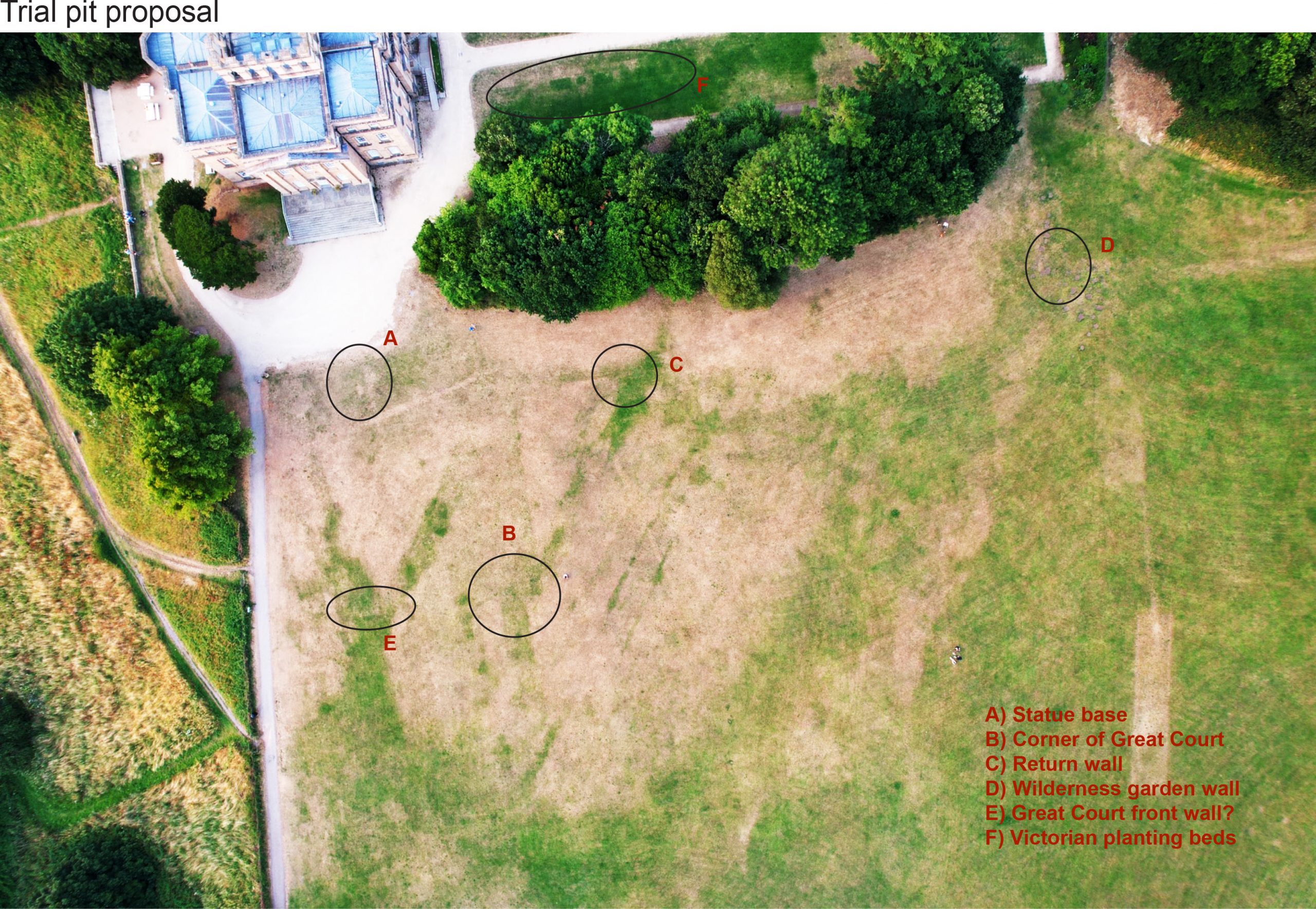
An enhanced version of the drone photo, kindly provided by Matt Ford. The house is visible top-left. North is approximately in the same corner.
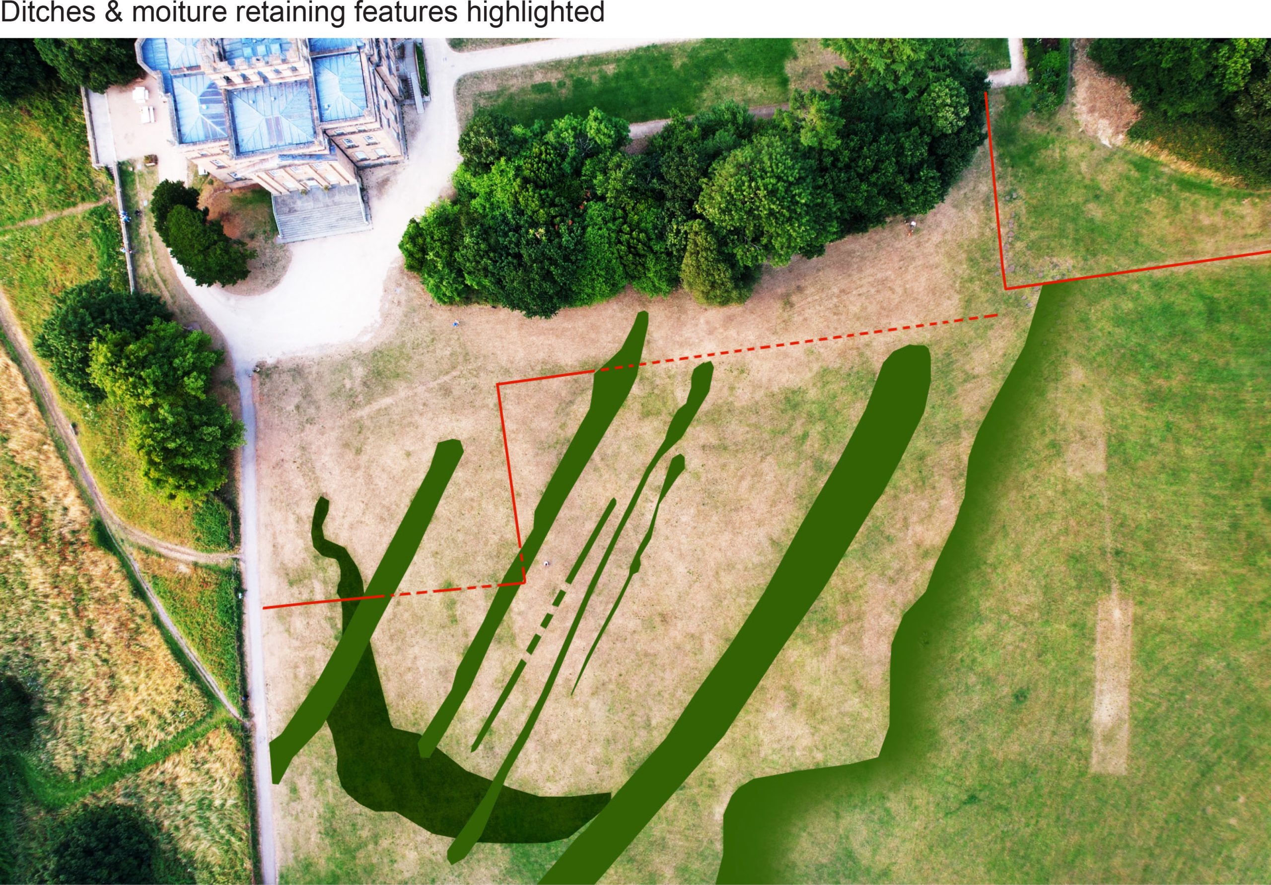
The first thing that probably stands out are the parallel green lines running diagonal to the house. These were also picked up with geophysics surveys and represent low-density, moisture-retaining features that have allowed the grass to remain green for longer. We now think the most likely explanation for these is that they are part of the underlying geology, running roughly aligned to Penpole ridge.
The irregular parallel features retaining moisture, and showing as green grass on the aerial photo. Enhanced photos showing the feint traces corresponding with the corner of the Great Court and the path aligned with the restored avenue.
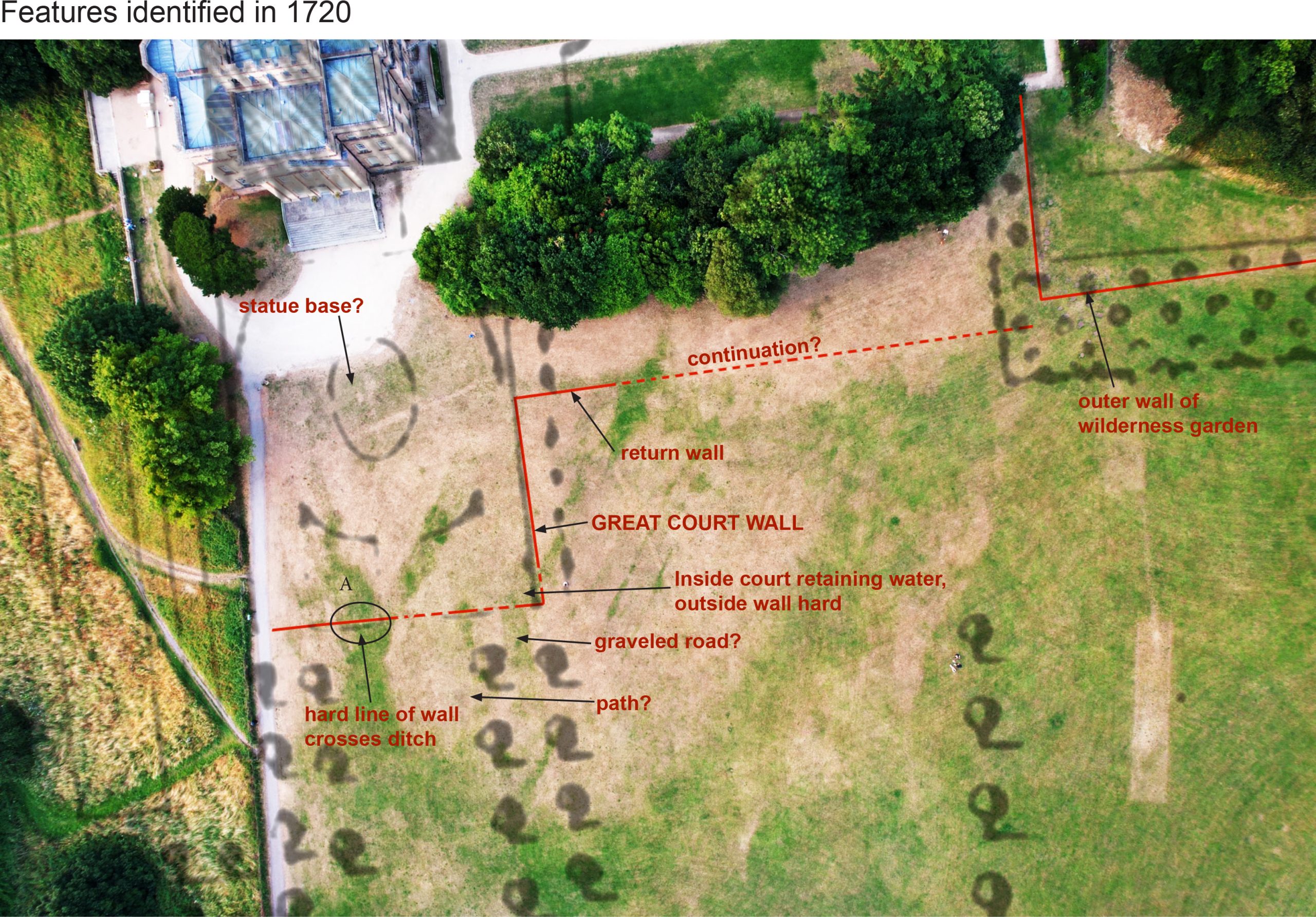
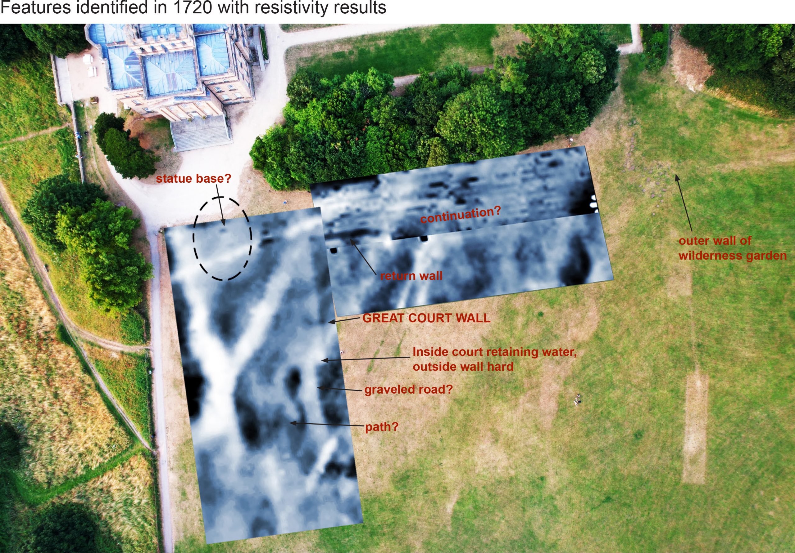
You have to look a little closer to start picking out some of the lost historic features. We knew the outline of the Great Court in front of the main front of the house remained as a shadow in the geophysics data, but the hot weather revealed it physically on the ground once more. The court was created as the grand formal setting that helped frame the grand main facade of the house when it was rebuilt to the designs of Sir John Vanbrugh from 1712. The aerial photo includes a clear demarcation of the side and front walls, with a pronounced corner being the most defining feature (feature B). Also visible are wide strips of green heading away from the house and the Great Court. These are part of the parallel avenues of lime trees that once connected to The Circle as part of a grand axial arrangement, and alignment of out 2014 trees corresponding with that line.
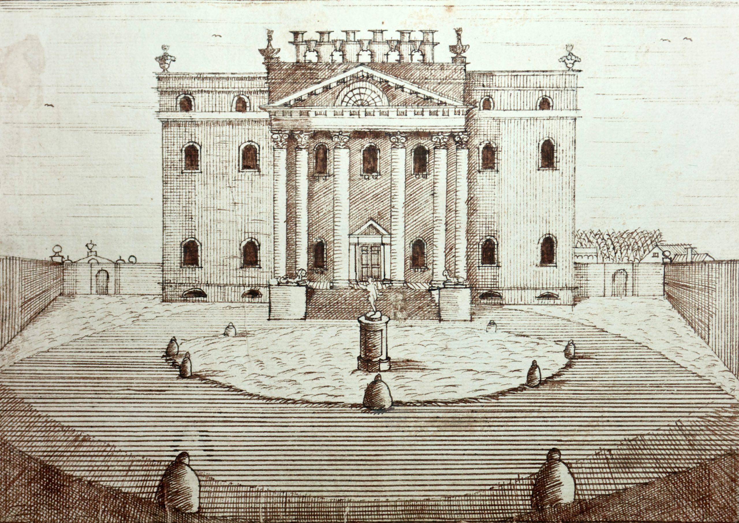
Halett’s 172 map of the estate overlain, with features showing as parch marks identified. The Great Court illustrated in 1746 by James Stewart. the statue is visible in the centre of the walled area.
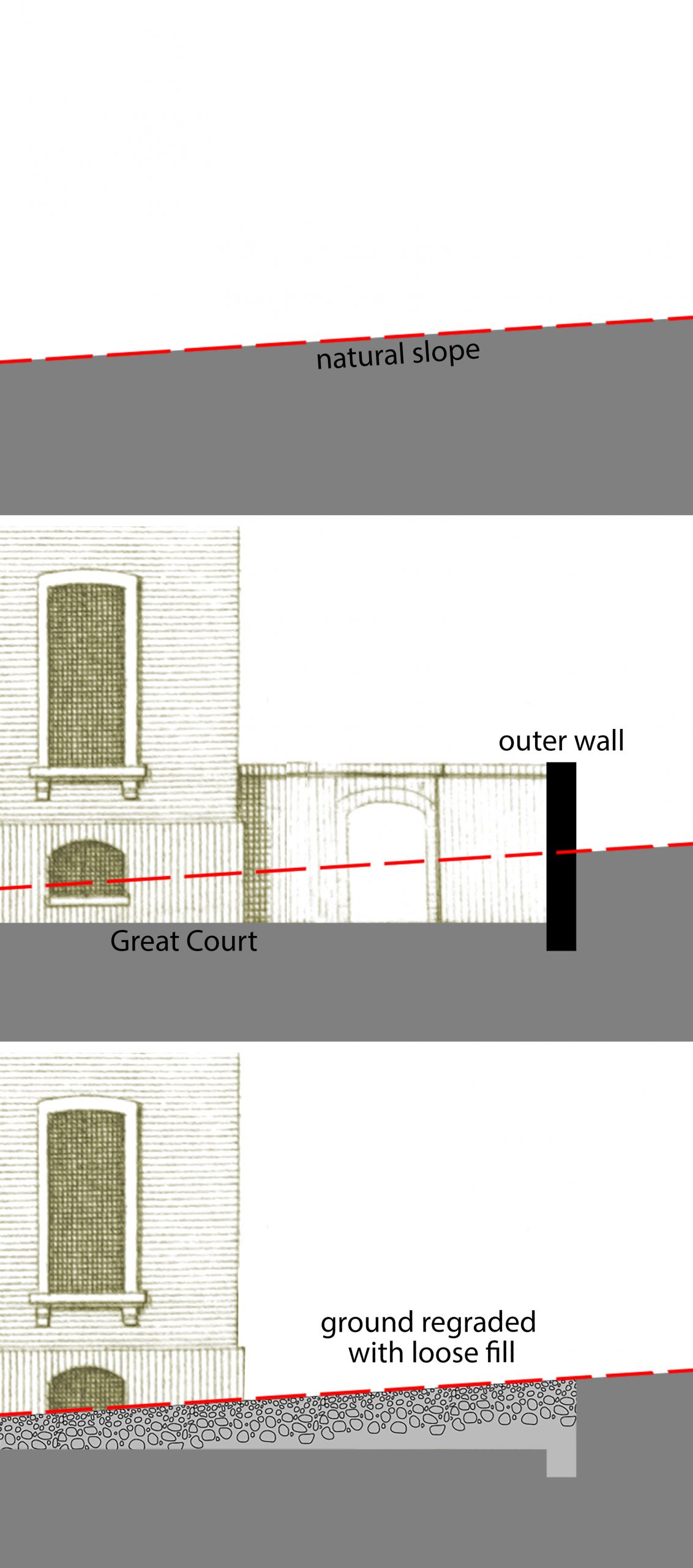
Diagram showing why the Great Court may be showing as a moisture-retaining greener area.
One thing that’s puzzling is why the Great Court shows as more green than the dry grass to the south. The visitor can still see the very shallow depression where the court must have been cut down directly into the rock to create a perfectly flat yard, so why would this not be harder ground with shallower soil that would dry out more quickly? It may be that, when the surrounding walls were taken down and the court deformalized in the 1760s, the ground had to be made back up again to form an unbroken smooth lawn. This would see looser fill material offering a better harbour for moisture, and explain why it read as low-density on the geophys. This also suggests the strips were also cut in, and later infilled.
The Great Court might explain another feature further to the north, a thin but defined line, that relates to the alignment of the front wall (Feature E). This was in the area covered by geophys, but there was no corresponding high-resistance feature that would otherwise indicate a wall. The jury’s out on this particular mark.
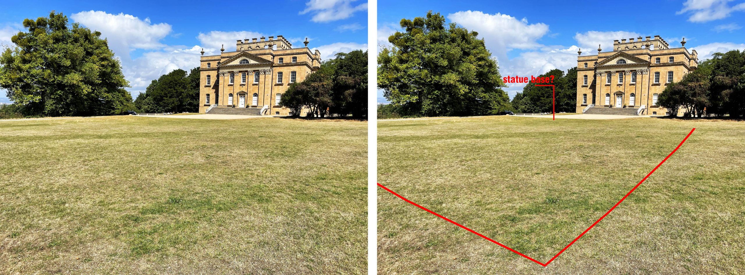
A pronounced feature (feature A) that does appear on the ground and the geophys is a hard lump or two nearly symmetrical with the front of the house. With its prominent location in the centre of the court it’s tempting to interpret this as being the foundation for the statue base for a statue of Hercules dating from the building of the house from 1712-1716; perhaps future excavation will reveal this and confirm whether the base of the statue of Hercules at Goldney House, Clifton, matches the one lost from Kings Weston.
Enhanced photos showing the corner of the Great Court showing up as a distinct green patch which continues towards the house.
Our second geophys survey in 2017 we supposed to be geo-referenced to make sure it overlaid with our earlier 2014 results, however, the parch marks now indicate that it was a bit off. We have now been able to correct the overlap between the two by matching the physical marks on the ground. Comparing both parch parks and the survey shows that there is a return wall (feature C) stretching southwards, away from the Great Court that adds to our understanding of the garden layout. It’s not a feature shown on any early maps, but probably dates to the same period as the mansion. It bisects the Great Court midway along its south wall suggesting that it was aligned to the centre and the statue location.
The archaeological geophysics results reconfigured over the parch parks, and showing correlating features.Enhanced photo showing alignments of a linear feature and the outer wall of the wilderness garden.
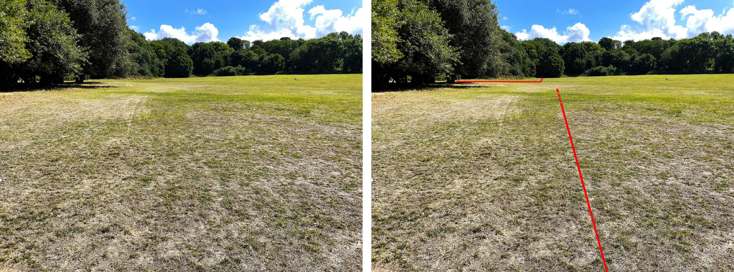
Another new discovery has been the locating of the garden wall of the second of the earlier large garden courts that spread out between the house and the Echo (feature D). We have this in early engravings and plans, but the parch marks now locate it physically. Marks show that the existing formal garden was designed to be slightly shorter, with the lost ‘wilderness’ garden beginning closer to the house than the current hedge. The marks also show that the wilderness garden was much wider than previously thought, and with this knowledge it’s now easy to see variations in the topography of the field that likely relate to it. This area may be worth looking at for archaeological excavation to explore what features might remain from this important 17th Century feature.
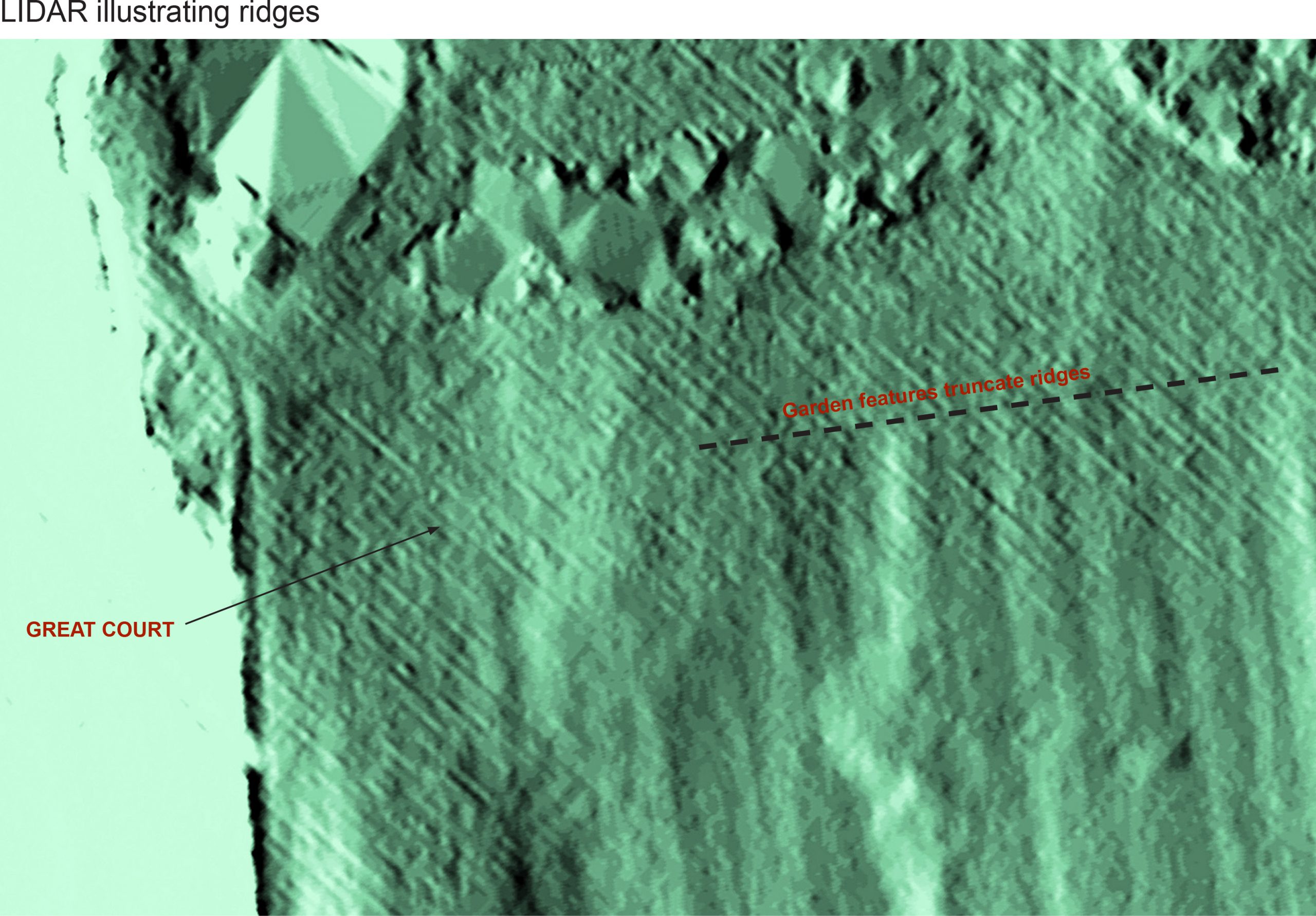
At this point it’s worth bringing in another survey technique: LiDAR (Light Detection and Ranging). This uses laser measuring to create a hyper-detailed topographical survey that can be adjusted to highlight lumps and bumps on the surface of the land. We know from this that there are a series of regular parallel ridges across the whole of the lawn, and that these don’t relate to the natural bedrock below. We don’t know what they are, or why they’re here, but we can tell is that they pre-date the 17th and 18th Century garden features as they’re truncated by them.
LiDAR survey showing how the earlier ridges were truncated by later garden features.
One final detail brought out by the dry weather has at least photographic evidence supporting it; Moving attention to the garden front of the house there are marks in the recently laid lawn that correspond to alternating circular and rectangular rose and flower beds of the Victorian era (feature F). Perhaps a focus on this area in future years might reveal more of earlier garden layouts?
Key features identified on the enhanced aerial photo .
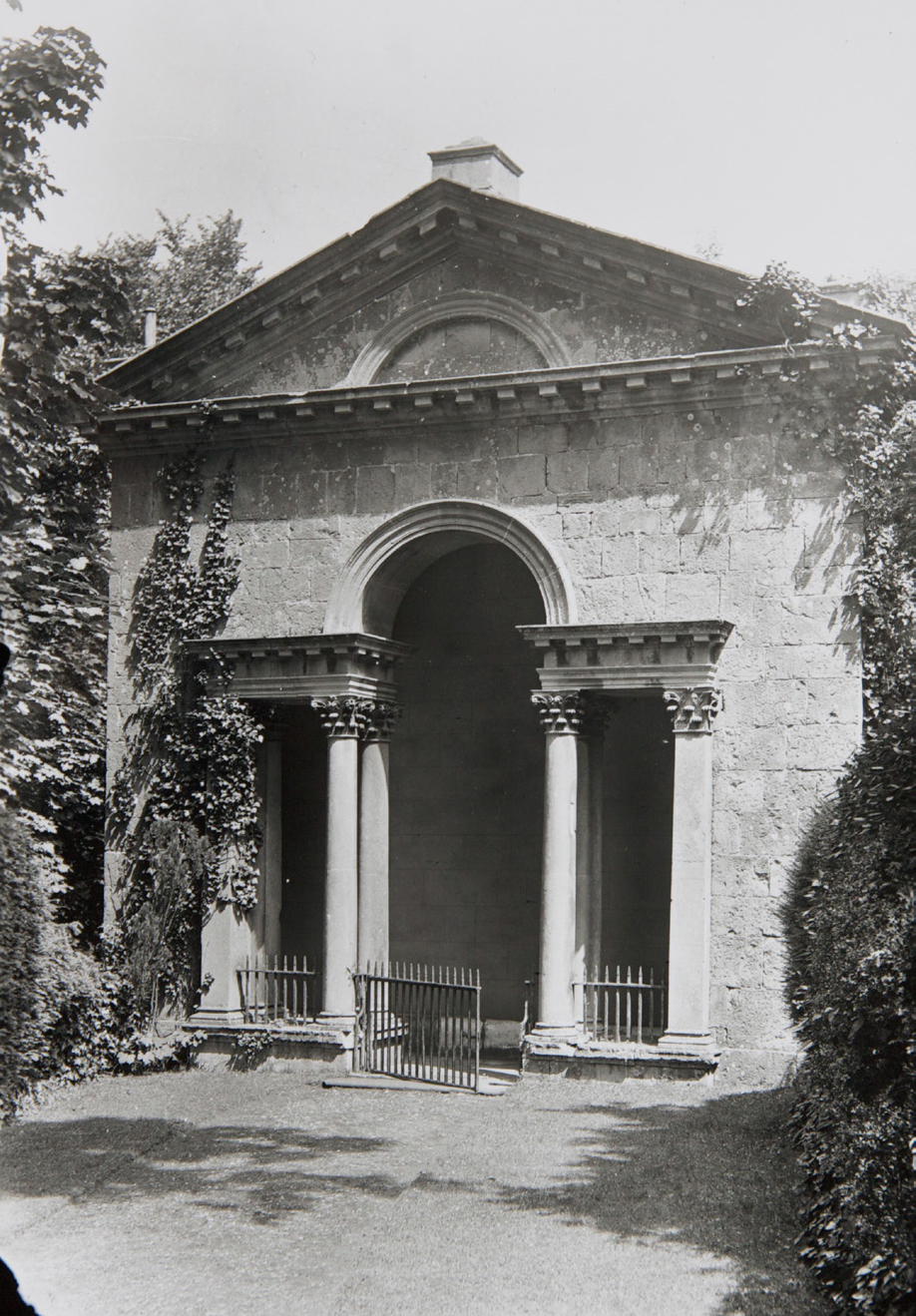
The Loggia, designed in 1718 by Sir John Vanbrugh. Seen here in 1927 (Country Life)
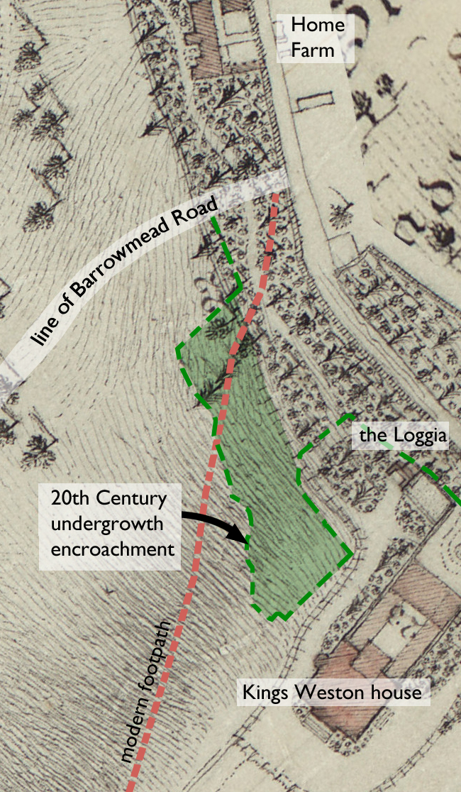
The area recently worked on by KWAG volunteers, just below the coffee shop terrace, Is an odd corner of the Kings Weston estate. Hard up against Kings Weston Lane in its gulley to the east it has always been an abrupt edge to the Landscaped grounds.
Before the present house was built the slopes descending towards Lawrence Weston here were laid out as formal kitchen gardens, though would have been sorely exposed to the brisk winds off the Severn. The top of the slope offered spectacular panoramas across the estuary and, in 1705, a banqueting house was built on a terrace overlooking the kitchen gardens. When Sir John Vanbrugh came to rebuild the house for Edward Southwell his plans extended to major landscape interventions. The small banqueting house received a new façade in 1718, one that looked back into the park and along a vast new terraced promenade; this building forms the core of the current Loggia.
As garden fashions changed the whole of the area below the banqueting house and Loggia were deformalised and the topography took on a form much the same as today’s. By 1772, when the area was surveyed by Isaac Taylor, only the Loggia remained, and the terraces and formal gardens swept away. In their place the open parkland swept unbroken to an area described as “verge plantations”. On his plan Taylor identified a railed fence separating the newly planted area from the recently created rolling meadowland below the house; the remains of this Georgian fence can still be found in the area recently cleared.
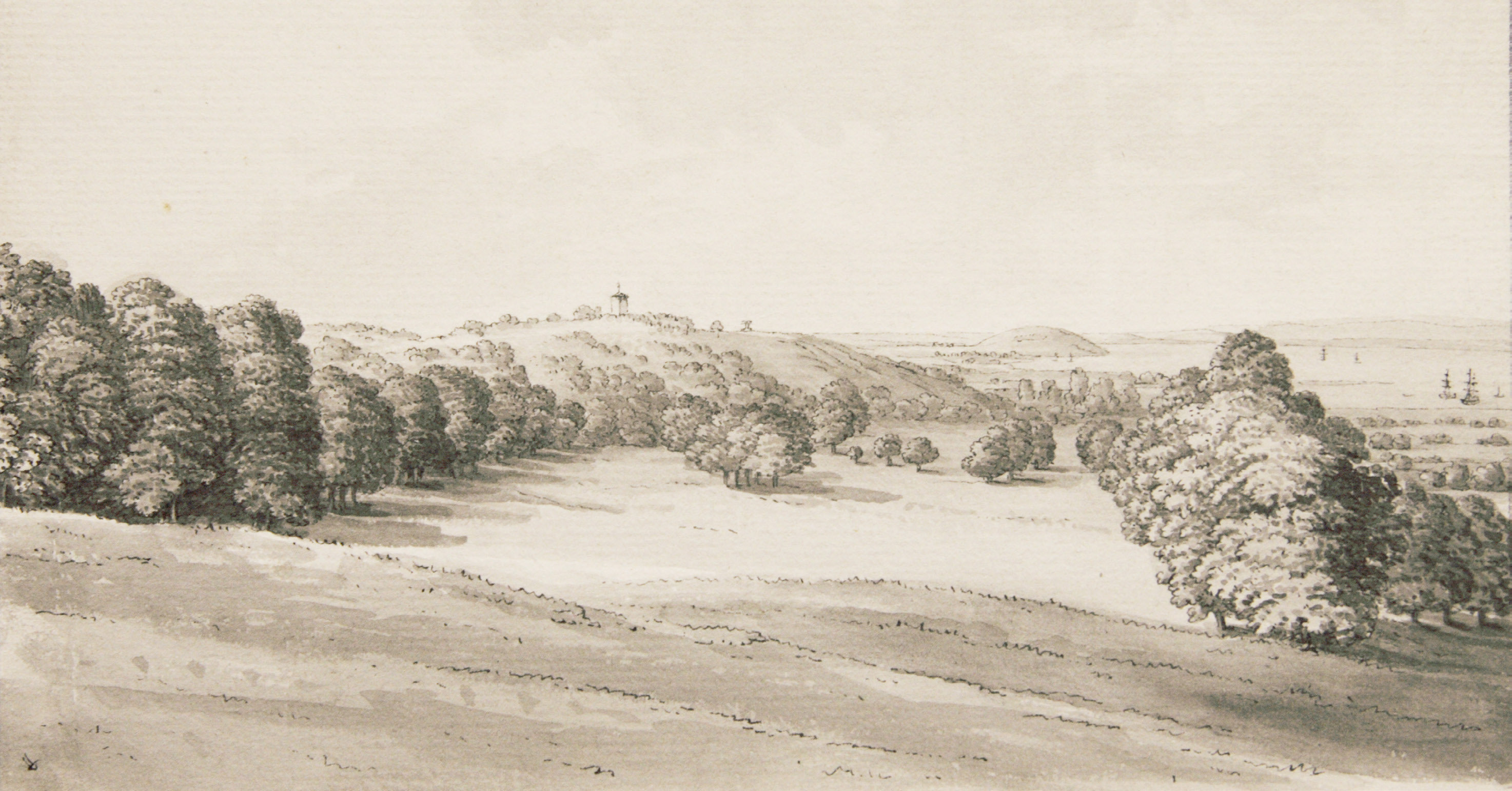
The view from the loggia across the meadow land. Hieronymus Grimm, 1788 (Bristol Museum and Art Gallery)
Taylor’s 1772 estate plan with later alterations annotated
Within the plantation new trees and shrubs were laid out as part of a pleasure walk that connected the house and Loggia with the Home Farm and Menagerie below. This planting would have been intentionally picturesque in style and some of the holly, yew, and Portuguese laurel from this era are still growing there, though the path has long become lost. Maps show there to have been many evergreens incorporated within a design intended to frame the open meadow and focus the eye on Kings Weston house commanding the ridge above it.
As time went on the trees and shrubs grew up and the view of the Loggia from the park was sadly obscured. The pleasure walk and planting continued to be maintained until the 1930s, but since then there has been little attention spared on them. Since WWII and the cessation of regular livestock grazing, this has resulted in the gradual encroachment of self-seeded trees beyond the historic fence line and the loss of the tamed edge of the meadow. Today trees cover almost twice the area of the original verge plantation and have further obscured the house and Loggia from within certain areas of the park. It is hoped that KWAG’s work, and forthcoming work as part of the National grid contributions, will help enhance the setting of Both Grade I Listed buildings and the park as a whole.
A new description of Kings Weston has come to light with some fascinating new detail about the estate dating from the height of its fame. The description comes from an Italian author, Luigi Angiolini, who was drawn to Kings Weston in 1788 by its international reputation. Two features in particular stand out in a translation of his 1790 book “Letters from England, Scotland and the Netherlands”, and are unique insights.
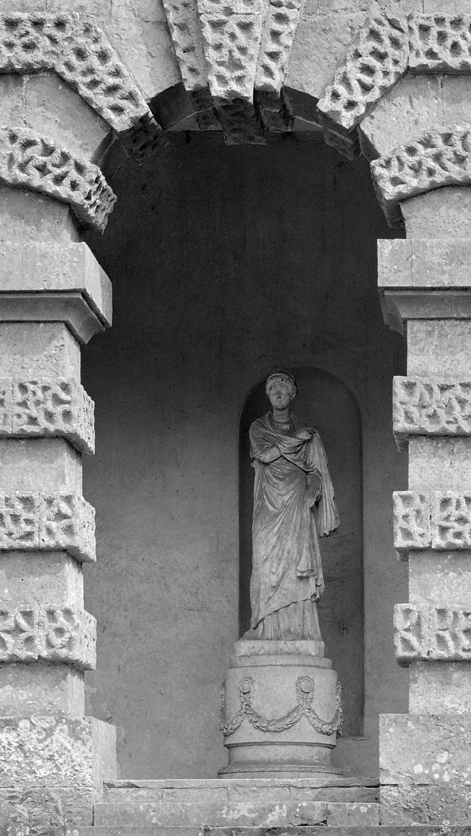
The statue in the Echo, 1927 (Country Life)
Describing his visit to the grounds Angiolini describes the long-lost statue in the Echo as being a “good ancient Roman” figure. This is the earliest mention of the statue we’ve so far found and adds considerable weight to our belief that it was a classical era state collected on the continent by one of the Southwell family and transported to the estate. Our identification of the pose as conforming to a standard classical portrait model, retrospectively categorised as “small Herculaneum Woman”, always implied that it was not a bespoke commission for the Echo. Had it been we might expect it to have represented a more recognisable deity.
We might hope that Angiolini’s assessment of the statue is based on a knowledge of ancient examples which, as he notes, survived in far greater numbers in his homeland; his countrymen lacking the same reverence or value that Gentlemen travelers from Britain attributed to them.
Sadly it’s likely that the only confirmation of the statue’s origins might come if it can be located, perhaps still, where anecdotal evidence suggests, tipped of off the terrace wall and into the ash pile close to the house.
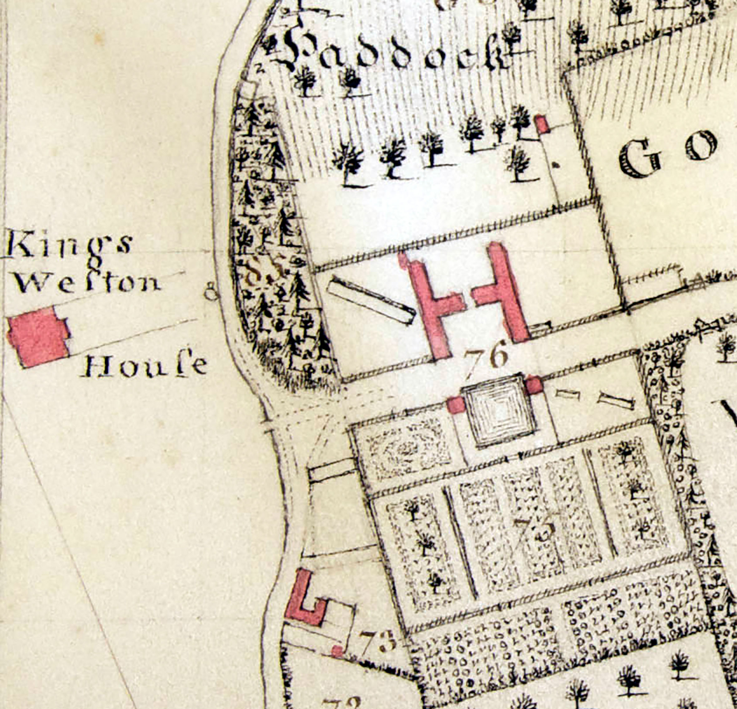
Detail of Isaac Taylor’s estate plan of 1772(Bristol Record Office)
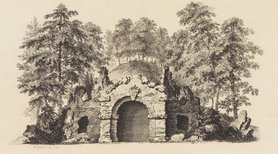
Angiolini also treats us to another revelation about the landscaped grounds; He mentions an “artificial cave”, made of wood, and hidden in a grove of evergreens. Five years ago we identified an unusual feature in a 1772 map of Penpole Wood which may correspond to Angiolini’s cave, and, at the time, we tentatively attributed it to the landscape designer Thomas Wright. Since then we have proven Wright’s involvement in the design of the Kings Weston grounds and the description of a rustic wooden cave, intertwined with ivy, compares favorably with other known examples of then-fashionable grottoes and seats in Arcadian settings. Such examples of “grotesque architecture” were perishable by nature, an intentional contrast to the permanence of classical garden temples, and so often decayed unrecorded, but a quarried area adjacent to one of the paths through the woods corresponds to the map location.
An example of one of Thomas Wright’s designs from his book “Universal Architecture”
We are left to imagine what the structure looked like, but the closest example is the root house at Blaise Castle Estate. This was recorded by the artist Samuel Hieronymous Grimm the year after Angiolini’s visit to Kings Weston. Angiolini doesn’t mention visiting Blaise in his writings, and travels quickly on to Aust and the ferry to Wales. We trust that in describing the example at Kings Weston he was not conflating it with a similar rustic seat on the adjacent Blaise estate.
The root house at Blaise Castle depicted by S H Grimm in 1789 (British Library)
A full translation of Angiolini’s description of Kings Weston follows:
“It was a total satisfaction to visit the palazzo of the Lord; It is not big, but is tasteful, with portico supported by columns in Palladian style, which I liked. I will not speak at length about the different parts that compose it; the paintings are mostly Italian, few originals, many copies, including some very good. I was occupied with the pleasure gardens, even those said orchards, namely gardens of fruits and green vegetables. I will not dwell on the way they are maintained; It would be easier to perform than to describe what I observed. The park, which is well cut with many majestic evergreen trees, obliges one to take a path which is long but not tiring, because one is amused by many diversions of variety and innovation. If ever you came into these parts, do not neglect to educate yourself of a point half a mile from the palazzo, from which you can discover all the Bristol Channel at once, the outlet of ‘Avon into Severn, the Counties of Somerset, Gloucester and Wilts, and a large tract of country of Wales. In the Gardens there is a good ancient Roman statue for which a temple has been built, if not very large, very elegant and dignified. In England, perhaps for the rarity, you have a respect and a reverence for old things that we, too abundant of them, do not. In the midst of an evergreen grove, there is a pleasant surprise, a kind of hidden cave, made of timber and artificially covered in ivy that appears alive. Englishmen are unique in their knowledge of how to contrive art from nature. “


![005ADD000015540U00116000[SVC2]](http://www.kwag.org.uk/wp-content/uploads/2016/08/005ADD000015540U00116000SVC2.jpg)