Monthly Archives: November 2022

Excavations on The Tump   

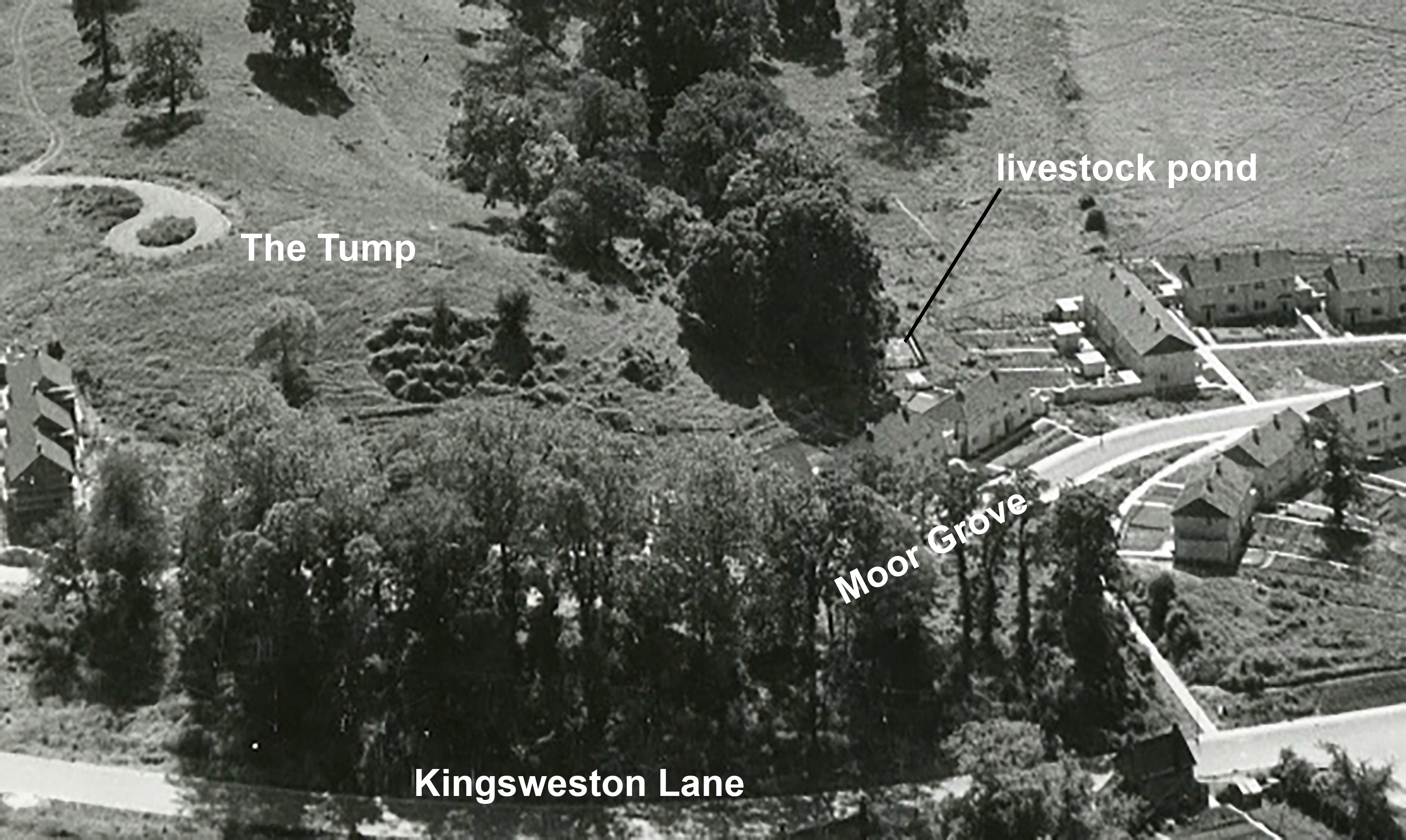
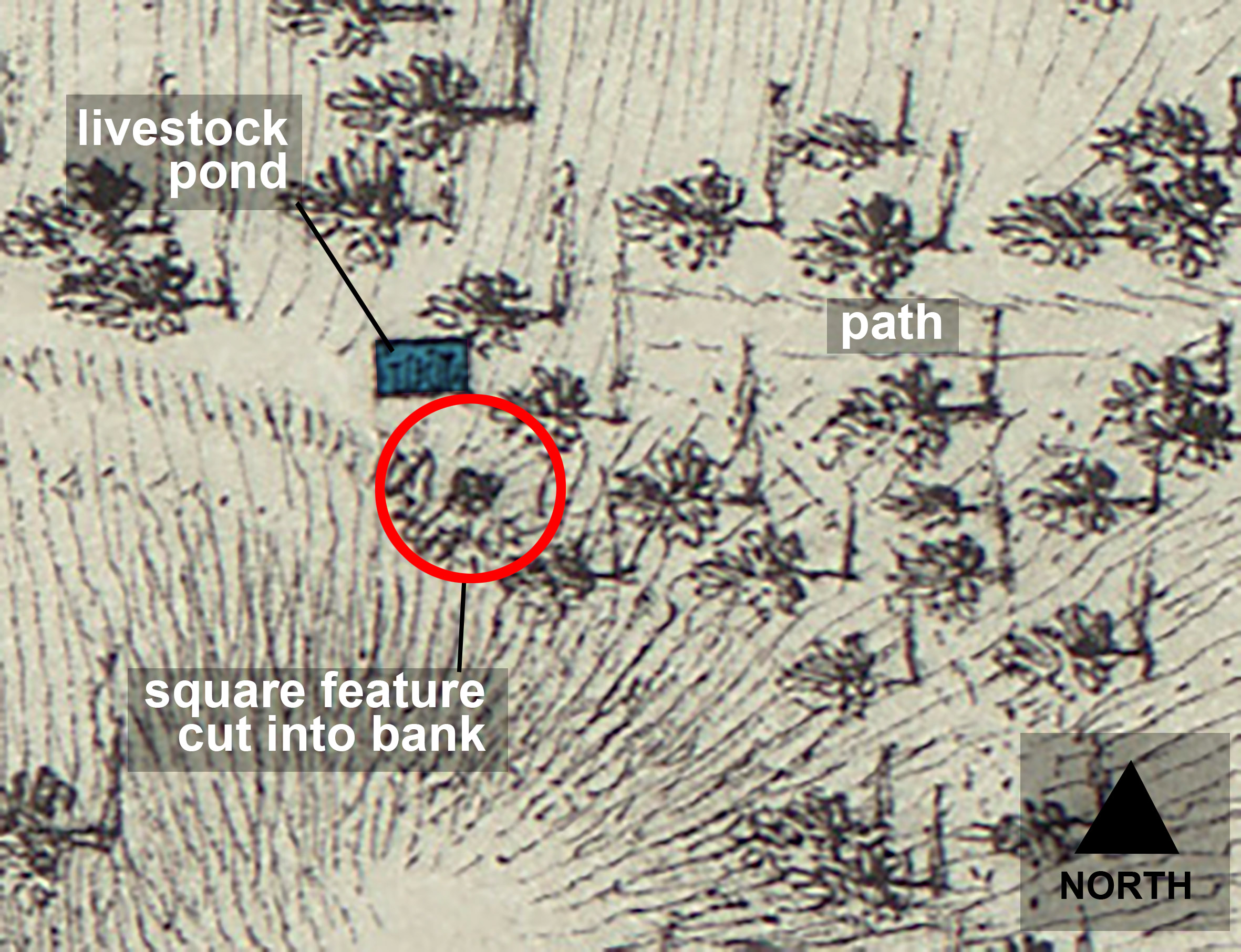
Long ago, when we were first exploring the historic sites around the estate a feature came to our attention on a map of 1772. It was drawn on an estate survey by Isaac Taylor, drawn in 1772 and now part of Bristol Archives collections.  A detail showed a rectangular shape, that we knew from later maps was a cattle pond, and a dark square feature shown excavated back into the slope of The Tump nearby. Again, looking at later maps this was marked as a well by the 20th century but its appearance on the Georgian plan raised the question whether it had begun as an ornamental feature in the landscaped grounds.

The location of the arch on The Tump 
 The arch exposed in the north slope of The Tump

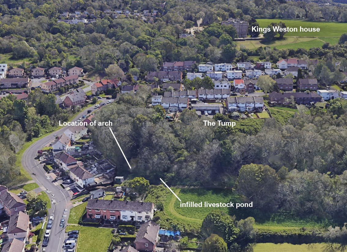
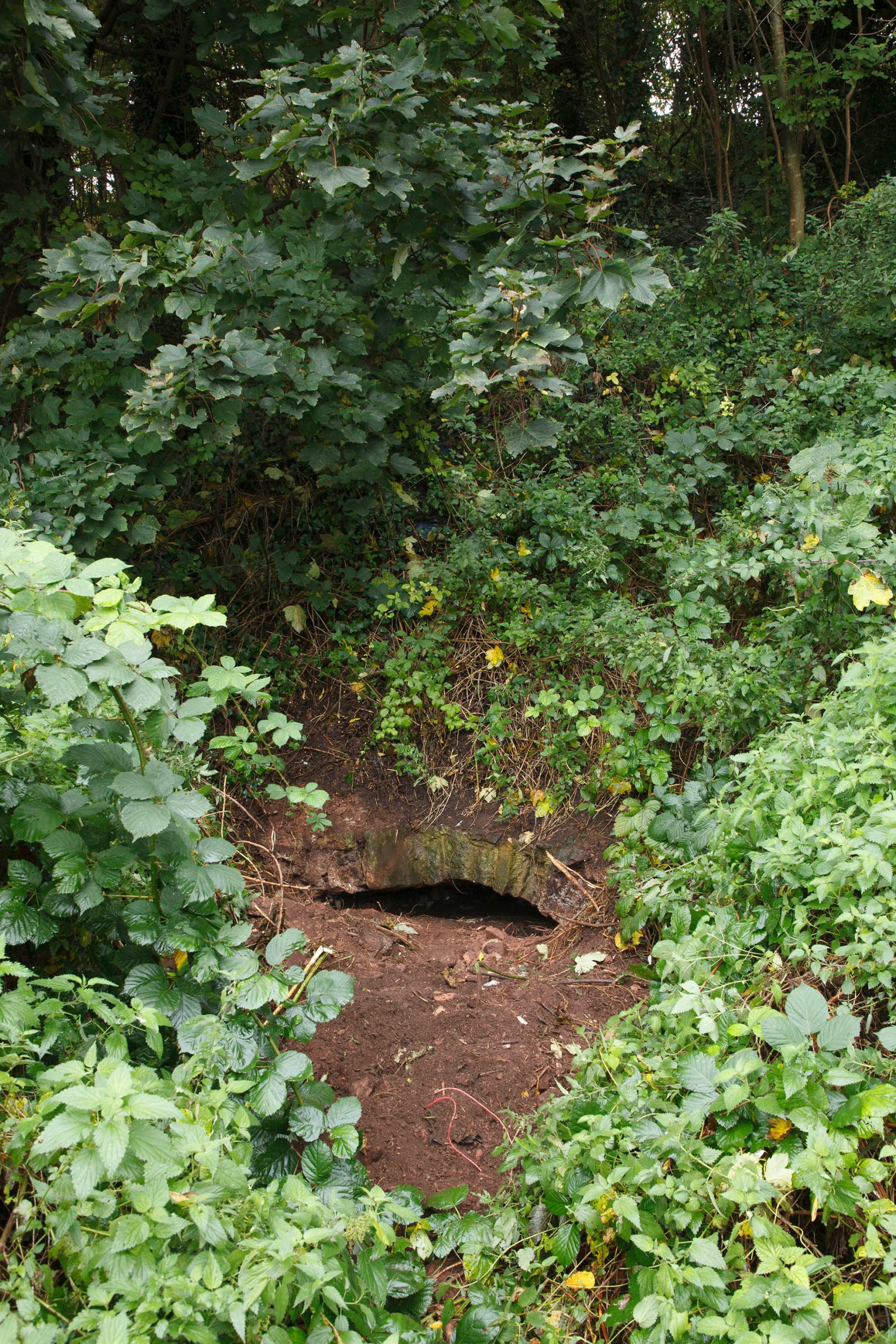
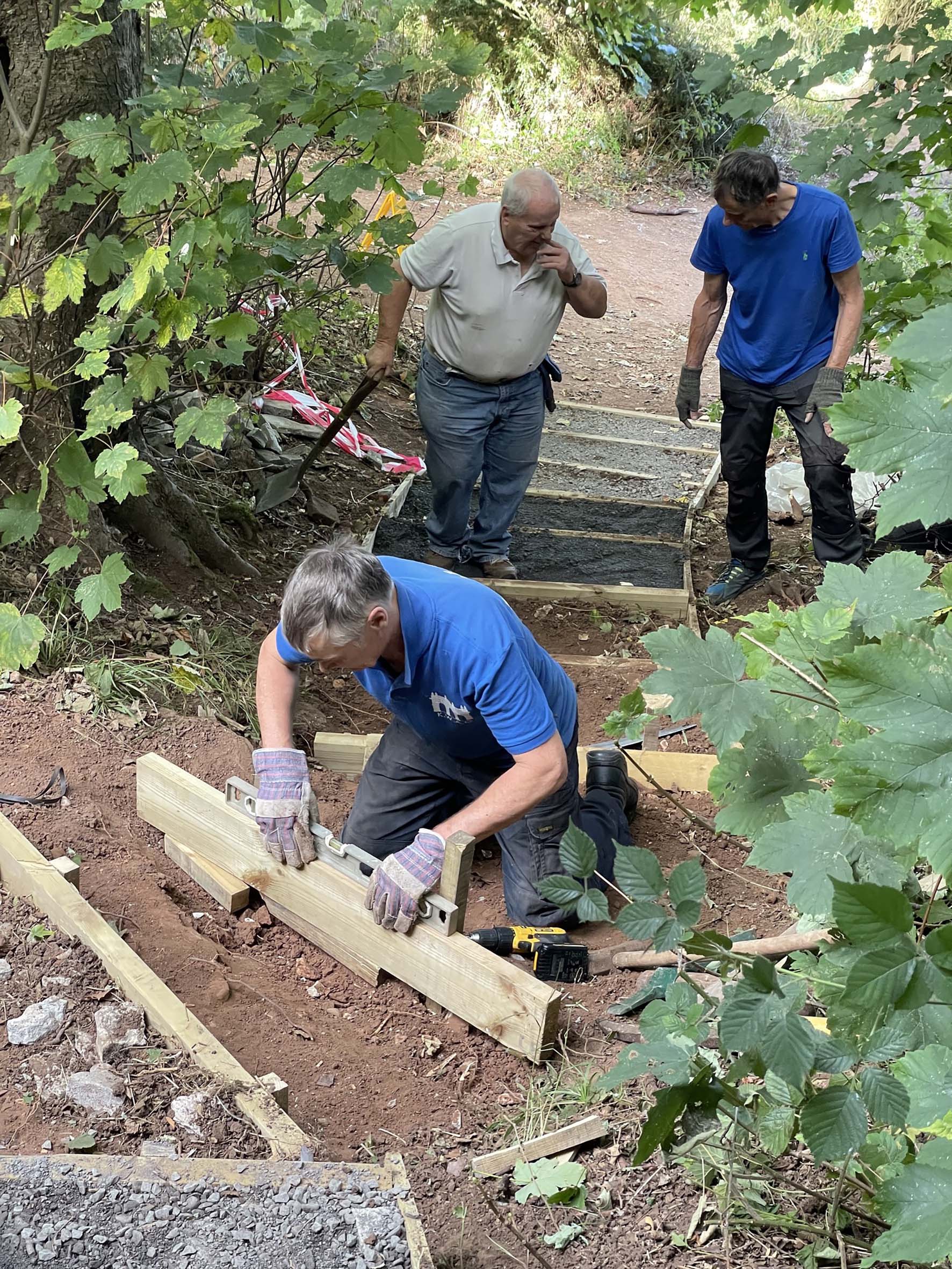
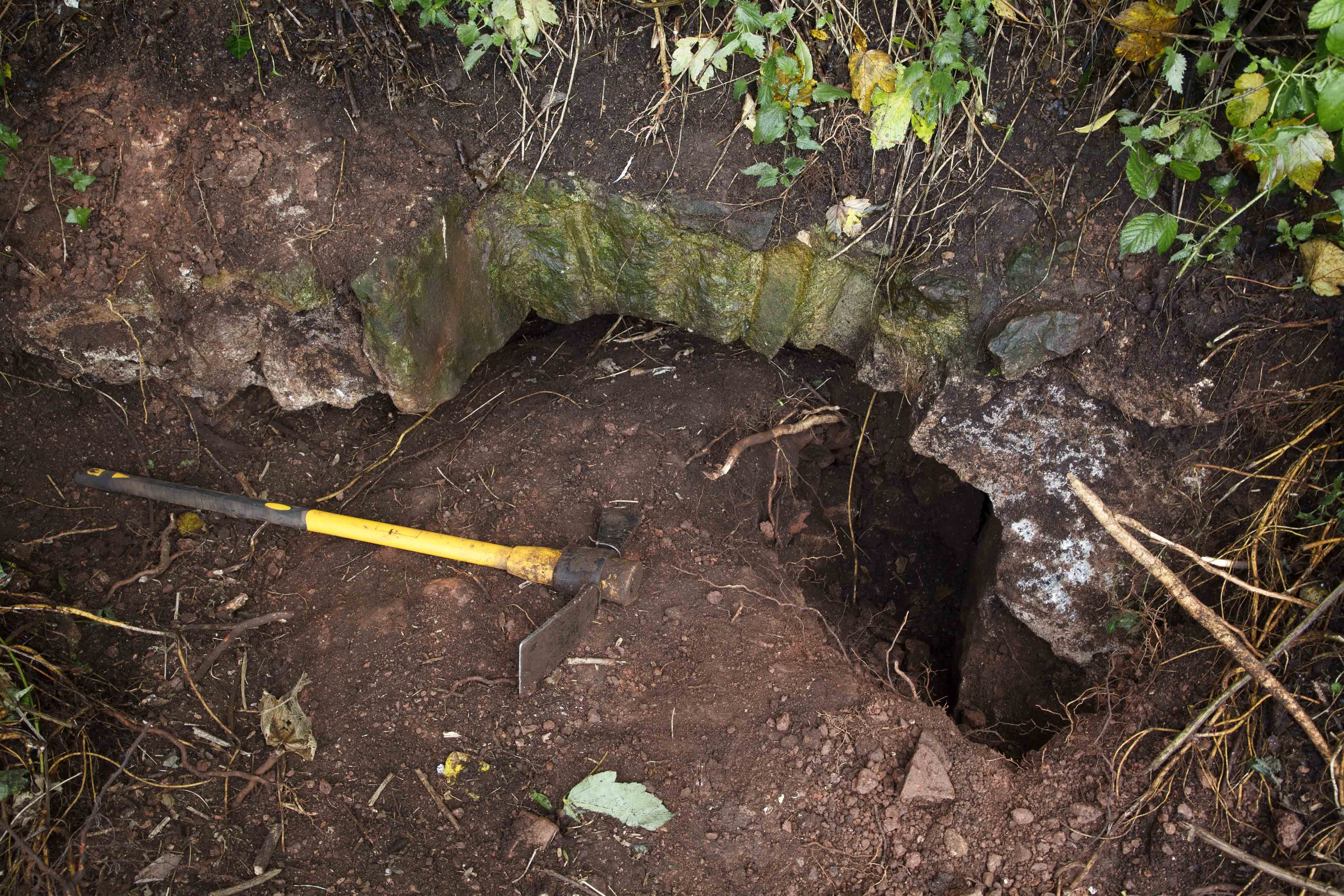
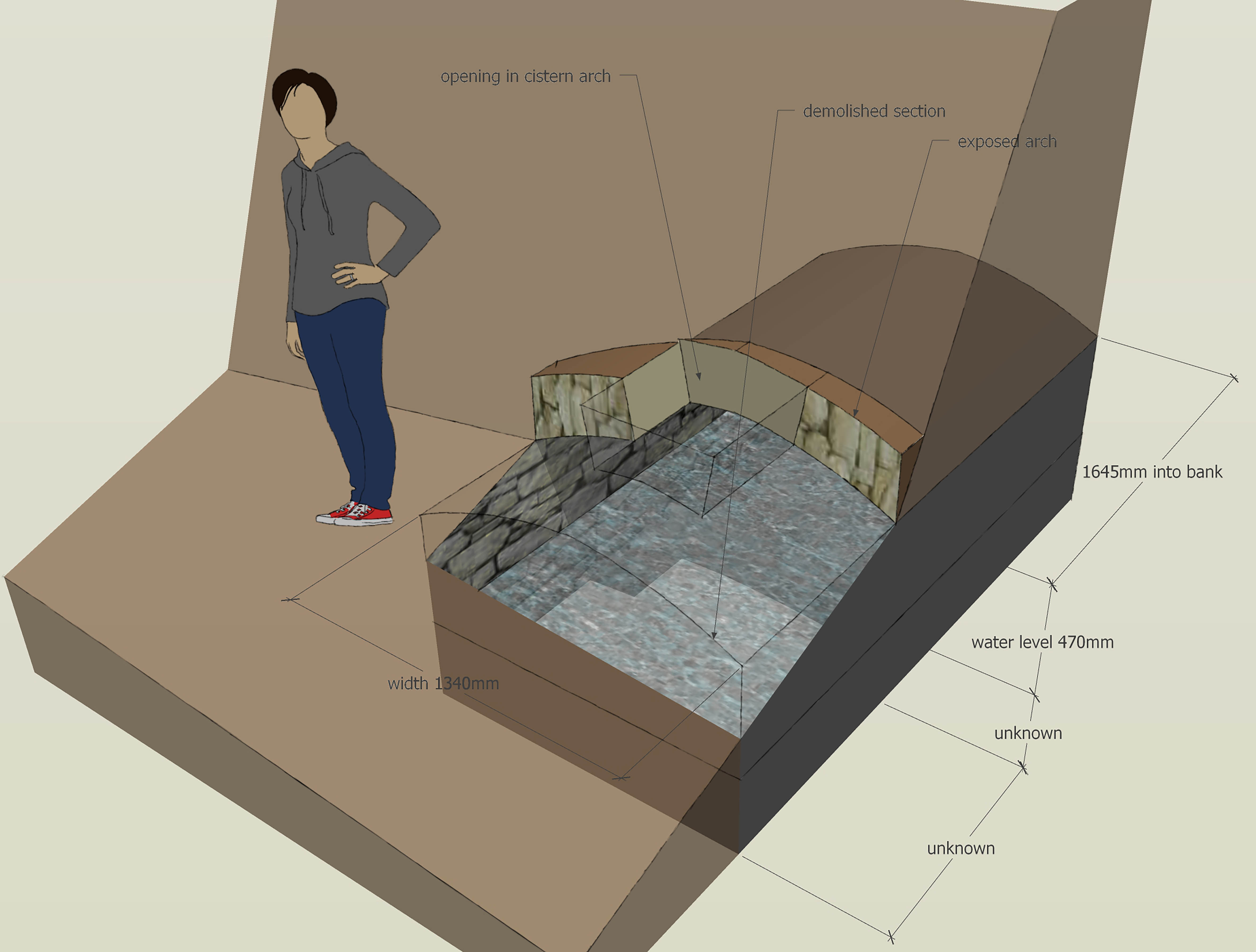
Back in 2011, when we were first aware of it, we searched the whole area in vain. The cattle pond remains broadly traceable alongside the path from modern day Moor Grove, but any remails of the other feature completely eluded us. When we returned to the area as part of research for last month’s newsletter we noticed something in the bank that we’d missed before: a low stone arch. We knew from an entry on the city’s Historic Environment Record that an arch existed close by, it had been reported as roman in origin, though was quickly established to be more recent, described as an “18-19th century spring head”. This corresponded with the feature we now saw on The Tump, and with the date of the Taylor plan. With the location now identified we set out to uncover what the arch was from. We undertook some superficial clearance of some of the undergrowth around the arch and excavated either side to establish how wide it was. The arch is irregular in shape, and roughly built. As found its crown was clear of the ground surface by about 20cm, but using a torch it clearly extended backward under the bank. When surveyed it transpired that it went back 1.7m under ground, ending in a flat rear wall.

The location of the livestock pond and square feature on the 1772 estate survey. 


 Cutting back either side revealed the arch was shallow, springing from two side walls 1.34m apart. The front sections of these walls, and the arch itself, were rough, indicating that they had been  broken away with portions demolished. The mortar holding the arch together contained lumps of ash and was white in colour, indicative of an early-mid 19th century date. The mortar of the walls appeared yellow and of different, earlier date. With the general dimensions of the remains established we sought to find out how far the structure once extended out from the hill, and where it terminated below ground. Digging down on one side the infill was loose rubble, so loose large lumps could be easily lifted out by hand. At a depth of 47cm below the springing of the arch there was a clear pool of water!

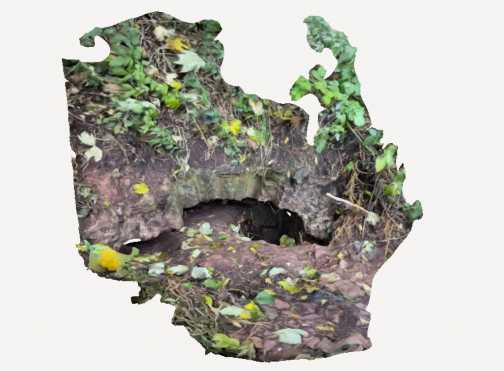
Something new for KWAG, we’ve utilised new freely available new photogrammetry technology to create a 3D model of the arch and cistern as excavated. To explore it for yourself follow this link: 
Spring head at The Tump, Kings Weston, Bristol – Download Free 3D Model on Polycam

The arch during excavation. the hole dug down on the right reached the water table around 40cm below the arch spring

Unfortunately, further excavations weren’t possible, but the exercise established a lot about the feature, its function and fate. It was clear that it wasn’t a garden feature, but a practical one. As suggested by the Historic Environment Record, it looks to be a natural spring that had a cistern built around it to collect water; this waster was used to feed the livestock pond just a short way downhill to the west. The 1772 estate plan may show an open cistern dug into the side of the hill. It appears that this had a vaulted roof constructed over it at a slightly later date, and from its location it would otherwise have risked filling up with silt washing off the hill. The irregular shape of the exposed edge of the arch represents a square aperture, an inspection hole or hatch, that would account for it being described as a well on later maps, despite having a very shallow water level and not being dug down in the traditional manner.

Scale diagram indicating the form and size of the cistern or springhead.
Image from a 3D photogrammetry model of the arch. Click on it to view the model in 3D


The animal pond survived the construction of Lawrence Weston estate around it, and is shown on aerial photos from 1950, glinting behind the houses of Moor Grove. No doubt this posed a health and safety risk to the new residents of the area, and it is reputed to have flooded downhill in wet weather, into the gardens of new houses. It would have been a practical necessity to infill the pond, and it’s likely that the spring or well head was dealt with at the same time, with the arch partially destroyed to enable its infilling with rubble. Whilst it wasn’t the imagined grotto or ornamental feature that it might have been the cistern is interesting, nevertheless. Its importance to the agricultural estates justifies its marking on the 1772 plan, and the relationship with the livestock pond shows how the opportunities were harnessed.

Kings Weston as a WWI hospital

We were recently sent this fascinating photo of Kings Weston house when it was in use as a WWI Auxiliary Hospital. It’s also unusual in that it is conveniently dated, to November 1918, towards the end of the conflict.

The photo was sent to us by Hazel Rowcliffe who shares that her grandfather is the gentleman playing chess on the right and he would have been 18 years old at the time of the photo. She says she doesn’t think he ever really spoke about his time in the war, but the interest he shows in chess saw him play competitively when he was older.

The scene is set in the library, now the Vanbrugh Room in the house. The tall library shelves have been stripped as part of the conversion of the room to a ward, along with all the family furniture and belongings. Only a remarkably tall mirror over the fireplace remains to ornament the walls, perhaps to large and fragile to consider moving. Temporary light fittings are rigged-up hanging from the shelves for the beds, each of which displays a red cross on its linen.

The nurse on the far right looks to be Sybil Napier Miles, the wife of the ‘squire’ Philip Napier Miles. She wears three bars on her left arm denoting three years of service as a volunteer nurse, which would correspond with the time that Kings Weston had been operating as a hospital. She took on management of the auxiliary hospital when it opened in 1915, and received the OBE for her efforts.  

Painted from Penpole – a new discovery  

A recent new acquisition is this watercolour painting of Kings Weston house framed by the trees and lodge at Penpole Point. The gates separating the common land on the Point from the private woodland walls is firmly shut and the top of the lodge is almost enveloped in ivy. The sun makes the golden stone of both buildings glow in the early autumn light. This was once a well-known view of the house, being the subject of several other known paintings, but inclusion of the lodge in the view as well is unusual. The view to the house must have been obscured by trees not long after this painting was created as we have no later image from this perspective.

It’s an important find for a couple of reasons; first it was painted by a well-known local artist, Thomas Leeson Rowbotham (1782–1853), whose paintings form a major component of the city museum’s Braikenridge collection. Most of these date to the 1820s and were commissioned to record historic buildings and monuments in the city, though the Kings Weston painting falls outside of that collection. It’s also significant for its very precise date – September 21st 1848 – just a year short of 175 years, almost to the week. It’s a late work by Rowbotham, then aged 66, the artist surviving just five years longer after its completion.  

Kings Weston house and Penpole Lodge from the point, Thomas Leeson Rowbotham, 21st September 1848. 

Stepping-up to the task – new Penpole Wood infrastructure  

As promised earlier this year, we’ve been planning a new set of steps in Penpole Wood to create a safer and more accessible access from Mancroft Avenue. This is a well-used entrance into the estate from Lawrence Weston, but paths are indistinct, steep, slippery, and dangerous, especially in the winter months. The path is particularly well used by students of the Oasis Academy on Penpole Lane.

During the 1930s when Bristol’s Scout groups ran a camp site here they constructed timber steps linking the open fields below the wood with the best camping ground at Jubilee Clearing at the top of the woods. These have long gone, along with the Scouts, so it was down to KWAG volunteers to step up to the challenge.

We had to work with a small project team of volunteers because of the restricted working area, dangerous slope, and the need for a wide working area for tools, so sorry if you hoped to help out but were unaware of the opportunity. Working over two consecutive Saturdays in September this small project team has hacked-out the earth to create a set of 16 new steps, formed timber risers and edges that needed to be hammered into the ground, and finished the treads with hardcore and gravel for good drainage.

Having completed this flight we recognise that a couple more steps might be required at the bottom to improve the approach and we’ll look at this soon. So far the response has been really positive and we’re grateful to everyone who thanked us during work on the project. We’re not sure what the scouts would have made of our new infrastructure, but we hope they would have approved of our workmanship. 

Lawrence Weston – a legacy of estates 

Looking north from the house today it’s difficult to reconcile the Lawrence Weston housing estate with the Kings Weston historic parkland. The Lower Park on which it was developed was once a key component in the designed landscaped grounds, dropping away to reveal the spectacular views across countryside towards the Severn, and acting as an artificially picturesque setting for the house in the opposite direction. It’s harder still to conceive that the designers of the post-war estate acted with sympathy to the historic setting they were provided with.

The Lower Park seen from Kings Weston house in 1789, by Samuel Hieronymus Grimm. Penpole Point is recognisable in the distance, with the lodge tower and stone dial. 
Cast concrete Easyform houses are erected on Mancroft Avenue. The angle of the photograph is not too dissimilar from the above painting. 

Immediately after WWII there was a housing crisis that dwarfs the scale of todays. Swathes of Bristol homes lay in rubble, others were unsanitary and decaying slums, and an influx of servicemen returning from war exasperated an already difficult problem. Just a year after the end of hostilities squatters were already taking up residence on some of the abandoned army huts elsewhere on the Kings Weston landscape. Recognising the urgency of the problem the city Corporation took the decision to lay out a large new estate to the north of the city, across the Lower Park of Kings Weston. The Scouts camping fields were acquired by compulsory purchase in 1947 and the rest of the land below the house secured for development.

Although it never hosted any ornamental parkland buildings the land added to the picturesque effect of the estate. By the 1770s it had been laid out in the picturesque Landscaped Parkland fashion, with clumps of trees artfully positioned in the naturally undulating land to frame views or catch the eye. The Tump, a natural hillock immediately to the north of the House, was planted with specimen trees, and some of a much older avenue trees retained and interspersed with these new specimens. Most of these trees remained after the war, and the Capability Brown-style landscaping remained intact.

1947 aerial view of the parkland with north orientated downwards. The open fields, scattered specimen trees, and clustered groups ac all be picked out.
One of the early planning drawings for the estate with north approximately downwards. Sites for a youth centre, pub, nursery school and new schools are indicated. 

Looking at the Lawrence Weston estate today you might think that it was imposed on the landscape without much thought beyond utility, but look closer and you can see its designers were sensitive to the task set of them. The City Architect of the time, Nelson Meredith, was particularly alert to the city’s historic buildings and unique character, and often worked with an ambition to reveal and respond to historic buildings, albeit in a way we might think insensitive today.

In this 1949 photo the flat roofs of the concrete Easyform houses on Mancroft
Avenue reveal the historic mansion above the growing housing estate. 

Meredith’s team of architects and planners set out the road of the estate in a way that maintained unobstructed views up to the mansion from Mancroft and Barrowmead Avenues, and from Long Cross. To ensure that new building had as minimal an impact as possible a flat-roof house type was developed and located where a traditional pitched roof would otherwise have interfered with these protected views.

The designers recognised the importance of the many mature parkland trees on the estate and sought to incorporate them within the overall design.  Where possible they were retained as part of main road frontages, with clumps being given greater emphasis as the focus of new park spaces. Broxholm Walk was aligned to respond to the line of the early Georgian avenue, “Wilcox Avenue” that once linked the house to the Tump, and some of whose trees still survived. The Tump was initially retained as an enclaved vestige of the open parkland, complete with trees an open grassland, though this was, in part, due to the impractical nature of the hilly ground. Today it is part of the Grade II Registered Historic Parkland along with the rest of the estate.

Sadly, over time the mature trees have gradually died and been replaced with more municipal style tree planting. Later houses like those on Sadlier Close have been less sympathetic to views of the house and tree-lined horizons of Penpole Wood. Even those built a short time after the original phases lacked the same understanding of the historic landscape.

Looking west across the Lawrence Weston estate circa 1952, showing the many mature trees and open spaces integrated into its design. Penpole Wood is in the background. 
1948 Roman villa excavations with Mancroft Avenue being built in the background.

The construction of Lawrence Weston did reveal something about the Kings Weston estate, hidden for many centuries: the Roman villa. When in 1947 Long Cross was constructed as the main arterial route through the new housing estate it sliced through part of an important villa dating to the 3rd century BC. Between 1948 and 1950 it was excavated, and the designs of the housing estate adjusted to protect it.

It would once have been the home of a prominent local family who likely depended on a sizable agricultural estate around it for their wealth. The villa faced uphill, southwards, towards what is now Penpole Wood, with an ornamental symmetrical façade. It was furnished with ornate mosaics, its own bathhouse, and later under-floor heating. It’s impossible to know the extent of the Roman estate, but it’s not impossible that ancient land boundaries persisted long after the abandonment of the site in the 4th or 5th Centuries AD, morphed into the Saxon manor, and that Kings Weston house is the direct descendant of the same Roman villa.