Monthly Archives: August 2017

New theories on Kings Weston’s Roman Landscape

Many in Shirehampton will know about the lamentable destruction of the former National School in the village centre a few years ago, well some interesting things have arisen since the loss that might start to outweigh the loss of the historic building. Last year Avon Archaeology undertook an excavation on the site and made some exceptional finds; the first significant Roman material found in Shirehampton beneath the Victorian foundations.

One of two bronze alloy broaches from the 1st or 2nd Century AD

Some of the pottery dating mainly from the 3rd to 4th Centuries.

As well as some fascinating individual finds including two fibulae brooch and a good quantity of pottery The dig identified a strong linear ditch feature into which much of the material had been deposited. This ditch, and an associated stone scatter along one side, support a new assessment of the Roman impact on the Kings Weston estate.

Linear ridges and shallow impressions crossing north-east – south-west across the meadowland of the Home Park have long puzzled us and our archaeological geophys surveys have not yet reached the most visually prominent areas to asses them. In association with our existing knowledge there is more exciting potential in these features.

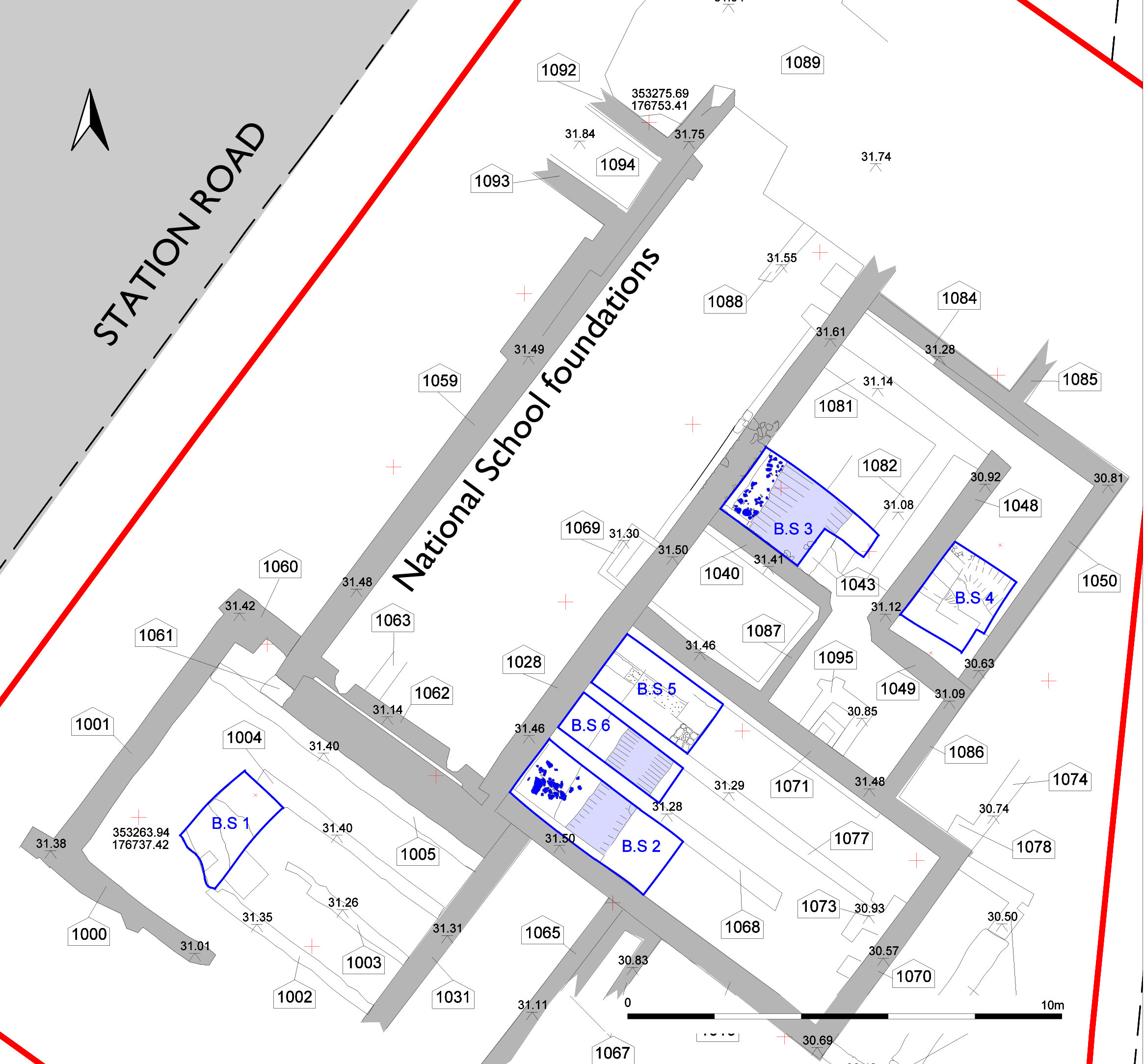
Roman linear feature and site plan (Avon Archaeology)

To the south of Kings Weston was the town of Abona, on the Avon at modern Sea Mills. Roman Roads can be tracked southwards and across Durdham Downs heading for Bath, and a major connection to Gloucester is known. It is significant that the known course of this road passes to the north side of the Kings Weston Ridge, continuing a line from Cribbs Causeway through Henbury. However, if that line is projected onwards it is not to Sea Mills that it heads, but directly through the Kings Weston Parkland to the old ferry across the Avon to Pill and the Somerset side of the Avon.

The recent finds in Shirehampton now give greater weight to the route of the road passing across the Home Park, Down Park Hill, then heading towards the banks of the Avon at Lamplighter’s along the modern course of Station Road; From there significant settlements at Gatcombe, Charterhouse on Mendip, and Ilchester would have been directly connected with Gloucester.

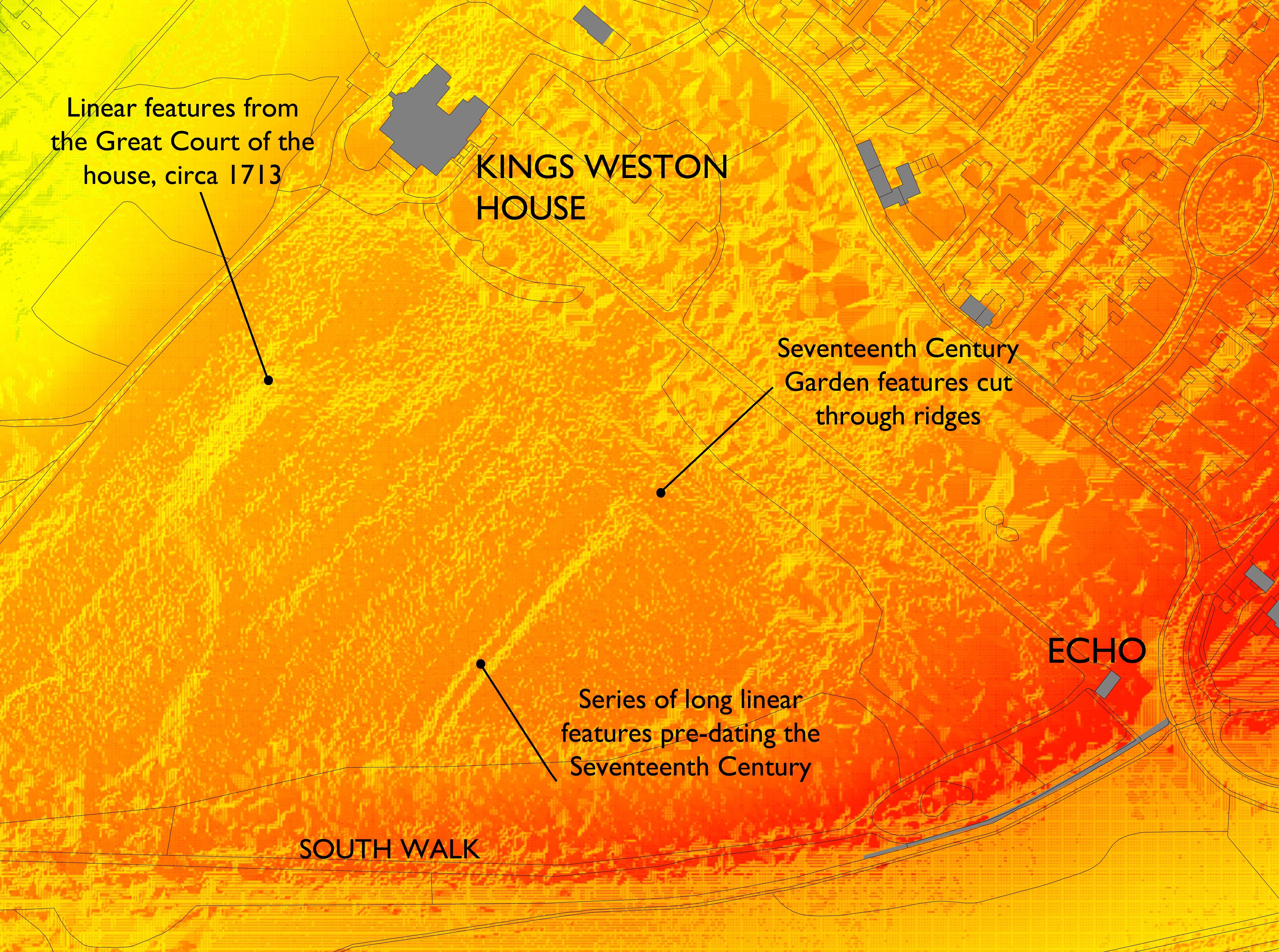
LIDAR data showing the landscape features around Kings Weston house in high relief.

A review of the archaeological record for the road from Bath towards Abonae also suggests that that road too bypassed the settlement proper and headed across the river Trym in a characteristically straight line, and crossed Kings Weston Hill at the Old Inn, and by way of a zig-zag known to have existed before the 1730s.

What this means for Kings Weston is significant. The conjectural new alignments give great potential for undisturbed Roman material being located within the flat land around the Home Park, and close to a major junction in Roman Roads. The nature of that junction, the foundation of the medieval manor at Kings Weston, and the efforts made by the Southwell families and those before them to divert the road outside their park might now be explored within this new hypothesis.

CLICK TO ENLARGE. Conjectural alignment of Roman Roads around Kings Weston with other sites.

Iron Bridge Update, August 2017

Some long-awaited progress to report from Bristol City Council regarding their repairs on the Regency iron bridge over Kings Weston Lane. This is the full text of the highway teams report:

Kingsweston Lane Footbridge was impacted by a HGV on the 4th November 2015, where substantial structural damage was suffered to the underside of this lightweight footbridge cast iron structure. There is already low headroom warning signage in place on approaches to this footbridge. The footbridge was immediately inspected on the same date and was subsequently closed to pedestrians on health and safety grounds.

As a consequence of the damage incurred the Council installed a temporary scaffolding bridge support arrangement above this footbridge to prevent the bridge itself from collapsing onto Kingsweston Road below. This support scaffolding was installed using an emergency road closure on the 5th and 6th of November 2015. The bridge remains closed to pedestrians. A signed alternative pedestrian route via Kingsweston Lane (including a temporary pedestrian crossing), is in now place. The road remains open to traffic. The alternative pedestrian route is inspected on a monthly basis

The Council is committed to reconstructing this listed historical footbridge and to reinstall this vital pedestrian link. However due to the listed status of the bridge and the paucity of existing information, further detailed investigation will be required to be undertaken before BCC are in a position to commence works on site. Subject obtaining the appropriate Capital Investment availability, this is provisionally programmed to be commenced on site early in the New Financial year, April 2018.

By potentially raising the headroom height of the footbridge it is hoped the mitigate the future potential for HGV bridge strikes, However this would change the appearance and would create pedestrian ramping on the approaches to the footbridge which may not be accepted by (HE) or BCC Planners. This will be investigated further by BCC and a decision made on the appropriate design accordingly.

The footbridge itself is constructed from numerous jointed cast iron elements and is also grade 2 listed, constructed circa 1800. The footbridge has received significant structural damage with the east side of the bridge sustaining major damage and loss to two arch beams which transfer the structural loadings of the bridge to the walled abutments on either side. These are the key structural members that hold the bridge in place and give it the required strength. To date we have luckily been able to find the old wooden moulds for these arch beams and have been able to source an suitable boundary and have had a replacement arch beam already recast and this is now in safe BCC storage awaiting to be installed.

We intend to use our Professional Frameworks Consultants (CH2M) to undertake the preliminary investigations, site surveys, Listed consent submission, detailed design/assessment, and Contract preparation and Tendering out to Market. The likely cost of this this commission brief would be in the region of £30,000.00 to include and cover the following phases:

Preliminary Design and Investigation Programme For Kingsweston Lane Footbridge

Phase 1: Preliminary Date: October 2017 
Undertake a full topographical survey of the bridge itself and the surrounding area of the bridge (15m either side). This will be done under a full road closure, organised by BCC. As this is a Conservation area we will need to consider the flora and fauna within the surrounding area , including bats and badgers etc.

Phase 2: Preliminary Date: November 2017
Inspect Bridge and determine the original method of original construction and connection. This will determine how the bridge is to be dismantled taken down, stored and then resembled. Undertake structural investigation and assessment as to the possibility of raising the bridge by about 400mm and look at the feasibility of this and the overall impact this would have in terms of access across the footbridge ect.

Phase 3: Preliminary Date: December 2017 
Liaise with David Martyn (BCC Historic Environment/Conservation Officer) on Listed requirements from Historic England (HE) for the dismantling, storage and re erection of the bridge. Consult with HE & Planning with regard to consents required to raise the footbridge if this is considered to be feasible.

Phase 4: Preliminary Date: January 2018
Submit required Listed Consent to HE and BCC Planning BCC and await outcome and further instruction.
Phase 5: Preliminary Dates: February to March 2018
Detailed Design, Contract and drawing Preparation, Tendering out to Market, Assessment of returns and award of Contract.