Monthly Archives: April 2017

Iron Bridge update. April 2017

We’re regularly contacted about the current progress on the Iron Bridge repair. We’re still in the position of lobbying the city council highways department to get some progress. We are aware that there are significant safety concerns about crossing the road close to Shirehampton Road junction, and the use of the bridge by trespassers crawling through the scaffolding, and have passed both issues on to the Council.  Rest assured that local Councillors Jo Sergant and Donald Alexander  have also been pushing hard on behalf of their ward.

The latest news is that it is planned that the work will be included within the current financial year, though this will be very dependant on budgets and other priorities within the city. We’re sorry that the news isn’t more positive, but the best advice we can give is to recommend you refer any queries, concerns, or issues directly to the councillors so they can pass them on to cabinet or the highways officers involved.

Tree planting with One Tree per Child

Following clearance of laurel and brambles last month saw the replanting of a large area around the White Oak in Penpole Wood with native tree species. Bristol City Council’s One Tree Per Child programme supported an event held on 23rd of March to involve school children from Kingsweston School in planting new 58 saplings.

Bristol Council's Jon Atkinson shows us how it's done

Bristol Council’s Jon Atkinson shows us how it’s done

Jon Atkinson, and volunteers from KWAG and Keynsham company, So Vision, set out the area ready for planting and helped in the work of planting.  Native species focused on native oak, lime and hazel and have been planted to complement the existing and rare White Oak which remains the central focus of this part of the woodland.

Children and helpers from Kingsweston School get stuck in with the tree planting.

Children and helpers from Kingsweston School get stuck in with the tree planting.

The original path through the area has also been informally reinstated as part of the work. The path will enable the saplings to be accessed for future maintenance and enable visitors to get much closer to the landmark White Oak, so please do take the opportunity to use it.


Unfortunately the new path has been deliberately vandalised, blocked, and the edging removed on two occasions now. If you know who is responsible please let us know, or report it if you see anything or find it removed again. Thank you.

The tree planting area and reinstated path below the White Oak.

The tree planting area and reinstated path below the White Oak.

Spies at large!

The recent publication, Somerset Mapped, by Emma Down and Adrian Webb, brought a curious new story to light. One of the maps reproduced in this volume represents the landscape around Kings Weston and the north of Bristol and was drawn up for a sinister purpose!

Tensions between France and Britain were frequently high throughout the Eighteenth Century, and both sides were keenly prepared if war broke out. It was important to plan for both the defence of your own territory, and, if necessary, the invasion of your opponent’s. With this in mind, in 1768, the French dispatched Lieutenant Colonel Paule St de Beville to undertake covert reconnaissance of key targets in the south of England.

Detail of Lieutenant Colonel Paule St de Beville's map of the Avon, 1768, from Somerset Mapped.

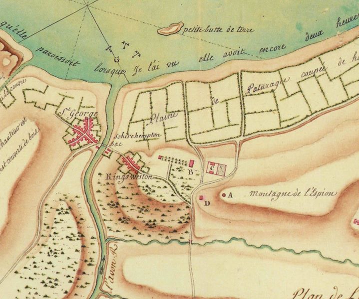
Detail of Lieutenant Colonel Paule St de Beville’s map of the Avon, 1768, from Somerset Mapped.

Part of his mission was to survey the landscape and provide detailed maps and analysis, which could prove strategically significant for an invading force. His map for the mouth of the Avon was drawn on the 18th September 1768 and is likely to have been drawn from memory, or notes, taken furtively during reconnaissance trips.

From the map it’s clear that he stationed himself at Kingsweston Inn (D on the plan) which he refers to as ‘Cabaret de l’espion’: tavern of the spy. The inn would have given him the perfect pretence to stay and survey the area, and was ideally located to provide a high vantage point from which to study the landscape. Kings Weston was firmly on the circuit of fine houses and gardens frequented by the well-to-do, and it had an international reputation that regularly attracted Continental nobility; a Frenchman visiting the estate, and staying in the inn, would be unlikely to raise much suspicion.

On Kingsweston Hill he identified the former windmill (A on the plan), which he’d established was stationed by a lookout in times of war. In describing the hill as the ‘mountain of the spy’ it’s clear that he used it as the principal station for his own observations.

Kingsweston Inn seen from below and from the south, circa 1820.

Kingsweston Inn seen from below and from the south, circa 1820.

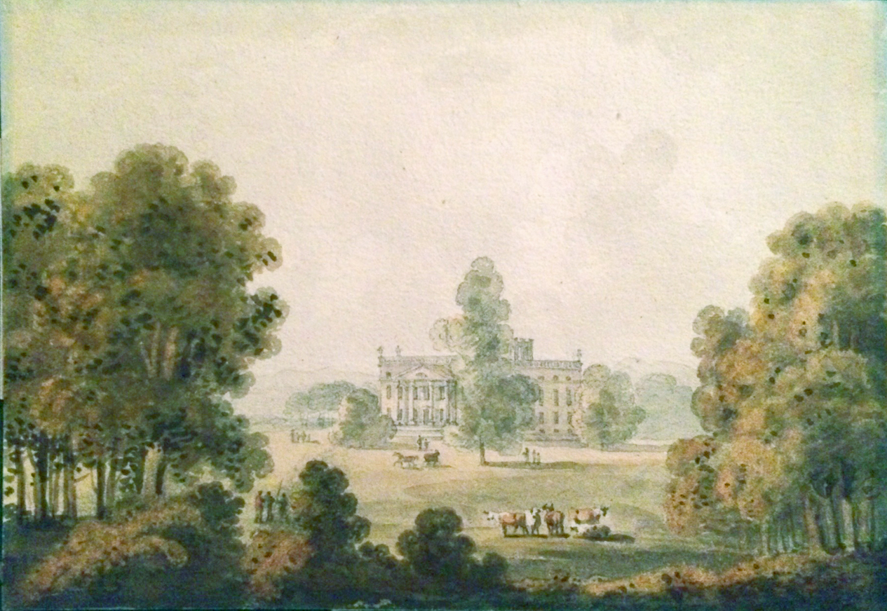
Kings Weston house and it’s recently completed stable courts, (B and C on the plan) have a recognisable relationship, and the avenue of trees stretching westwards appears to connect to Penpole Lodge, though the detail is more illustrative than accurate. Strategic features, such as the anchorage in Kingroad, and the ferry between Lamplighter’s and Pill are also shown, no doubt of significance to any army seeking to dominate the entrance to Bristol by land or sea.

How St de Beville interpreted the strategic significance of Kings Weston is difficult to say. He identified a potential camp for troops on a flat plateau around Nailsea that he’d seen at a distance, but the capture of the mouth of the Avon, and an assault on Bristol from the north, either from the Gloucestershire side of the Avon, or the Somerset side via Pill, would have relied on securing the high ground above Shirehampton. Perhaps Kings Weston house would have provided a suitable command post for operations?  In the event no such invasion ever happened, but signal masts were maintained on Kingsweston Hill for the duration of the wars with France that followed later in the same Century.

Unusual Georgian view discovered

A view of Kings Weston was recently sent to us which shows the house from an unusual angle. The view, painted in 1796, shows the prospect across the parkland from the South Walk, with the house framed in a naturalistic manner by groves of trees. This is the first illustration from this angle we’ve come across and is of particular note as it closely matches the views that KWAG restored during last year’s Lifting the Curtain project. The same angle is approximated in the masthead photo at the top of this month’s newsletter.

Watercolour of Kings Weston house from the South Walk, George Heriot, 1796.

The artist was George Heriot, a Scottish-born Civil servant who, at this time, had moved to the colonies of Canada. He returned briefly in 1796, when he painted this image, before returning to North America and developing a reputation as a major figure in Canadian Art.  This painting demonstrates not just the artist’s skill, but also that of the landscape designer. Edward Southwell III had de-formalised the grounds around the house in the 1760’s and we might assume that these copses of trees were planted at about that time to create picturesque framed views of his home.