There’s something of a 1990s revival taking over culture right now; baggy combat trousers are back and raves are in again. Frightening to think that it was around 30 years ago! The 1990s was a bad time for the Kings Weston Estate. The house remained in use as the Avon & Somerset Constabulary police training school despite their aspirations to expand across the park being quashed. They already planned to move to Portishead and minimal maintenance was undertaken on house or grounds. The thin sloping strip of Shirehampton Park along Shirehampton Road, between Kingsweston Hill and Penpole Wood, was the only part of the main parkland controlled by the Council.
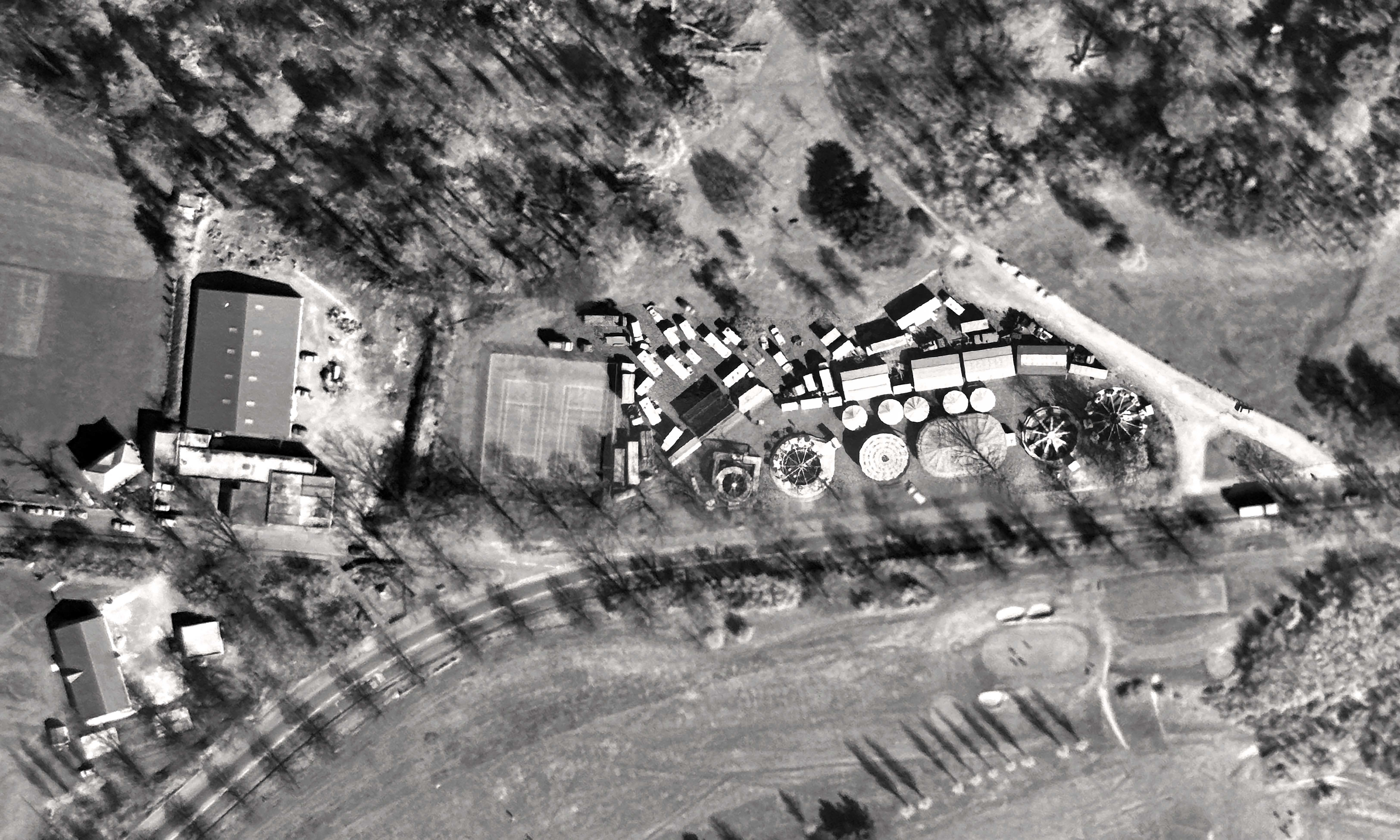
detail of the aerial photo survey flown over Kings Weston on 30th March 1990 capturing the funfair, tennis courts, and Fairways.
At the start of the decade the Ordnance Survey sent over its survey planes on one of its periodical photography missions. When it passed over Kings Weston in March it recorded an unusual visitor to the park: a funfair! The fair set up in a prime location on Shirehampton Road, between the Council tennis courts and the car park. It’s possible to pick out dodgems, carousel, and four other big rides as well as a small encampment of stalls, booths, and caravans. Newspapers reveal the fair was here for ten days from the 21st of March, open 6pm or 2pm on weekends, but no indication of which travelling fair it was. Does anyone remember other times the fair came to Kings Weston, or is this photo a chance record of the only visit?
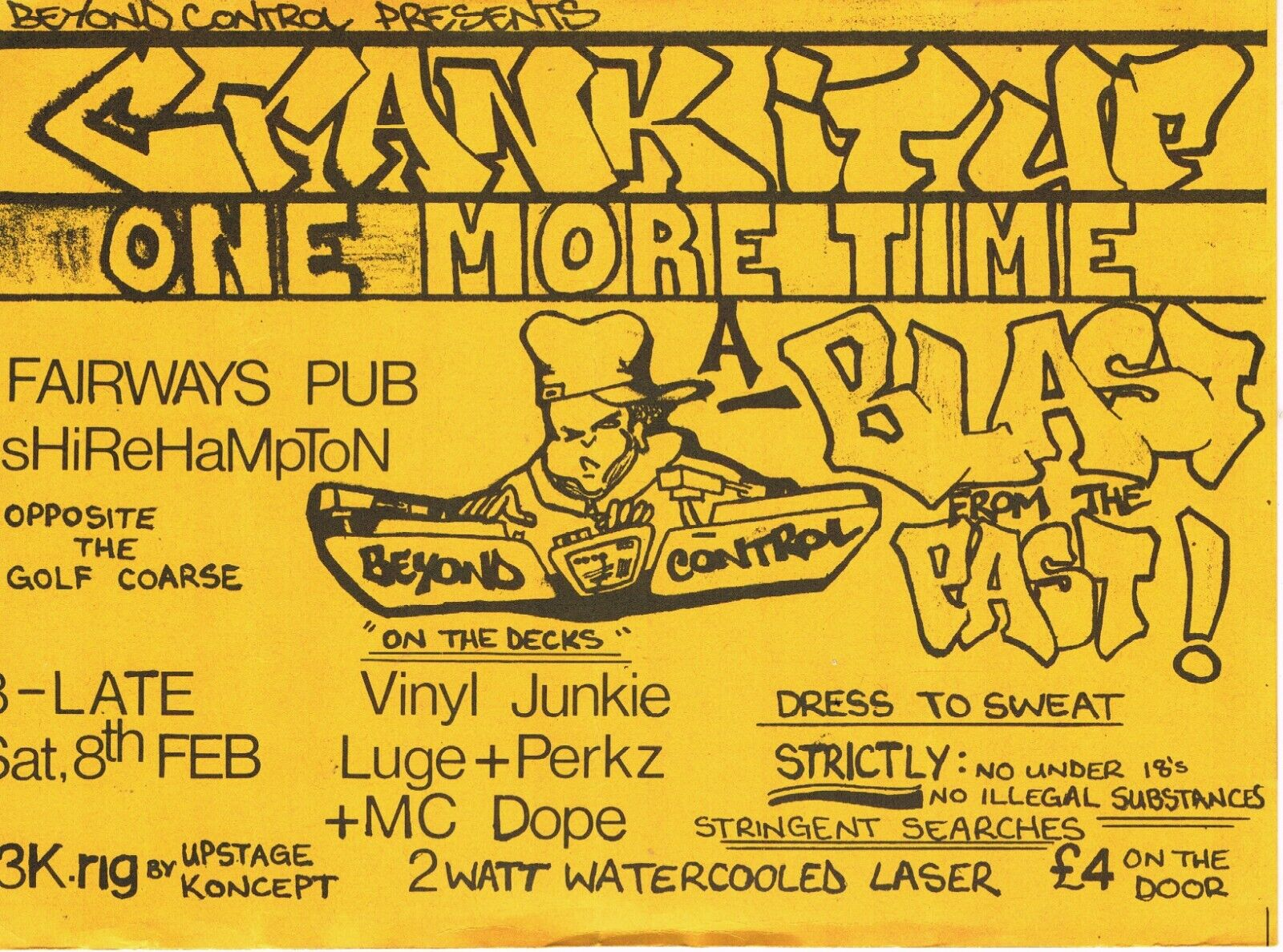
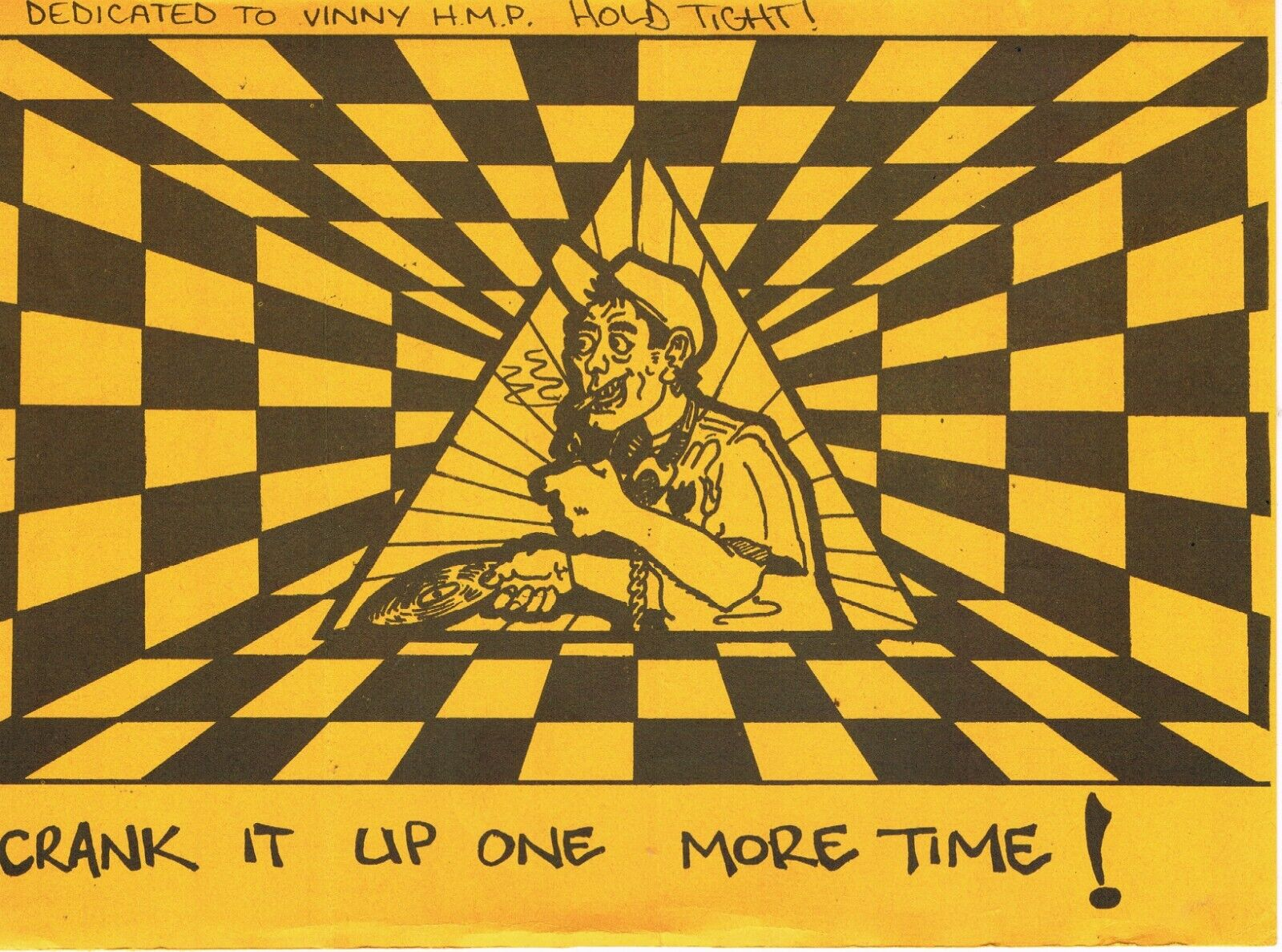
A couple of years later some alternative entertainment was going down on the estate – a rave. Now emblematic of 90s youth culture and fondly remembered by many, raves became a huge civil order issue for the Government. Many were illegally held, but, going by a flyer publicising the event, this one looks to have been more legitimate. In the days before internet and mobile phones in everyone’s pockets, flyers, often handmade, were an essential way to get the message out but rarely survive. The Crank it Up One More Time session was held at Fairways pub in Feb 1992 and promoted by Beyond Control. On the decks were Vinyl Junkie, Luge+Perkz and MC Dope – where are they now? Guests were advised to dress to sweat. We’d love to hear from anyone who remembers going!
An alternative souvenir from the Kings Weston estate in the form of a rave flyer for Crank it UP One More Time 8.2.92
The Fairways pub was just opposite the war memorial, on the present Karakal site. It had begun in the 1972 as a social club for Portway Football club who used the pitch next to the cricket club on Penpole Lane. It was an unglamorous single-storey building erected on land purchased from Bristol Water Works. It can be picked out in the aerial photo to the south of the old covered reservoir. Its construction coincided with efforts to establish a sports centre in the old reservoir building. By 1988 it was being advertised as Fairways pub, so it appears the football club had relocated to more suitable pitches in Sea Mills by this time. Although planning consent for a replacement purpose-built pub was granted in 1992 the old buildings continued until 1995 when it closed, never to reopen. The run-down buildings were demolished shortly afterwards, but by the time the owners of the site made any move to rebuild it things had changed, the estate was now nationally recognised for its historic value, planning policies had changed, and their new proposals were refused.
1970s Architects drawings of the sports and social club on Penpole Lane that would become Fairways pub.
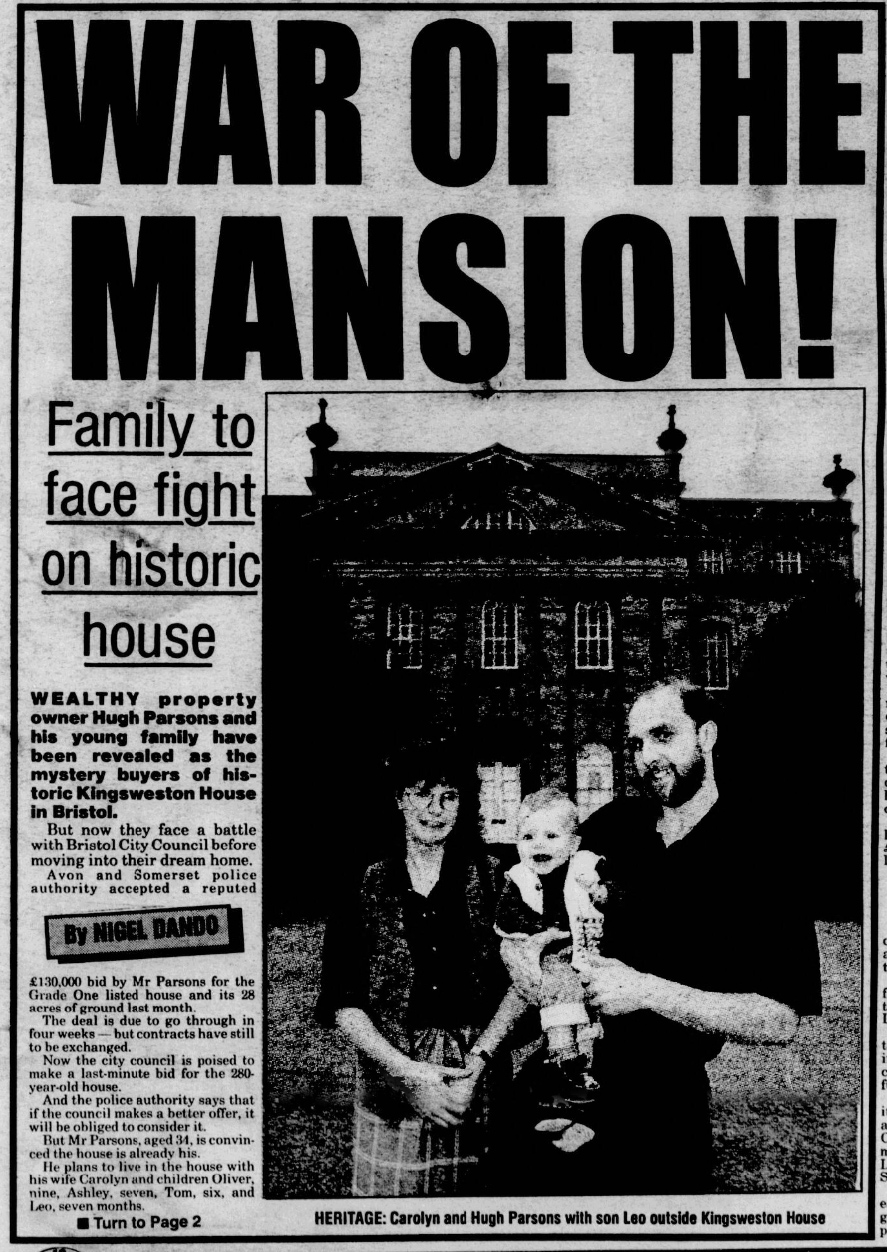
The most significant moment for Kings Weston in the 90s saw the future of the mansion and Home Park in the balance. Kings Weston house was put on the market by the police in 1995 with an asking price of £300,000. Ironically, this was £30,000 lower than the Council had purchased it for in 1970 before being forced to hand the property over to the police four years later when Avon County was formed. Initial reports in September that year suggested the police had accepted a £125,000 offer from “property tycoon” Hugh Parsons, but late bids were received from a developer seeking conversion to a nursing home, and another from the City Council keen to acquire the land and house for the public; A tussle ensued with legal threats flying. The battle over the bidding played out in the press for several months before it was announced in November that the council finally won with a bid of £300,000 and agreement that public access would be protected. Councillor Paul Smith, chairman of the city council’s land and building committee said: “The challenge for us now is to ensure it is properly looked after and the land kept open to the public”. How that came to pass is another story…
The Bristol press keenly followed the battle over ownership of Kings Weston house.
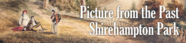
Another artwork with Kings Weston Interest has come our way recently. The panoramic views across the waters of the Severn to the north were matched by the rolling landscape framing the Avon and its gorge to the south. Both proved popular locations for picturesque paintings throughout the Eighteenth and Nineteenth Centuries. The recently uncovered work shows the view up the Avon from Shirehampton Park, a spot much-favoured by artists. Here, the view across Horseshoe Bend was attractively framed by trees along the parkland edge. Distant views of Cook’s Folly, a tower with romantic associations, added distant intrigue to the scene.
The painting is likely to date from the 1830s, before the twin towers of the Clifton Suspension bridge rose to punctuate the skyline. Our artist, whoever they might have been, has added a sentimental vignette as foreground interest. A young couple, the gent apparently an artist working on his own version of the same view, have been approached by a gentleman and his dog. It may be that, in his red tunic and walking stick, he is an old soldier begging for money, so adding a poignant human touch in the midst of such natural drama.
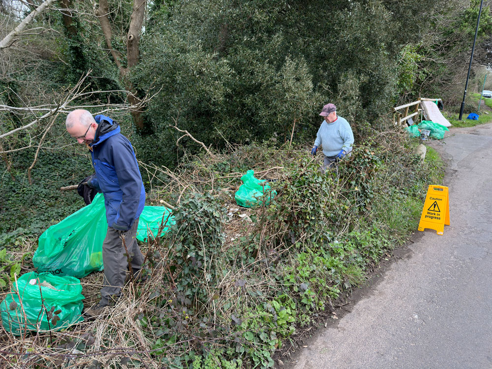
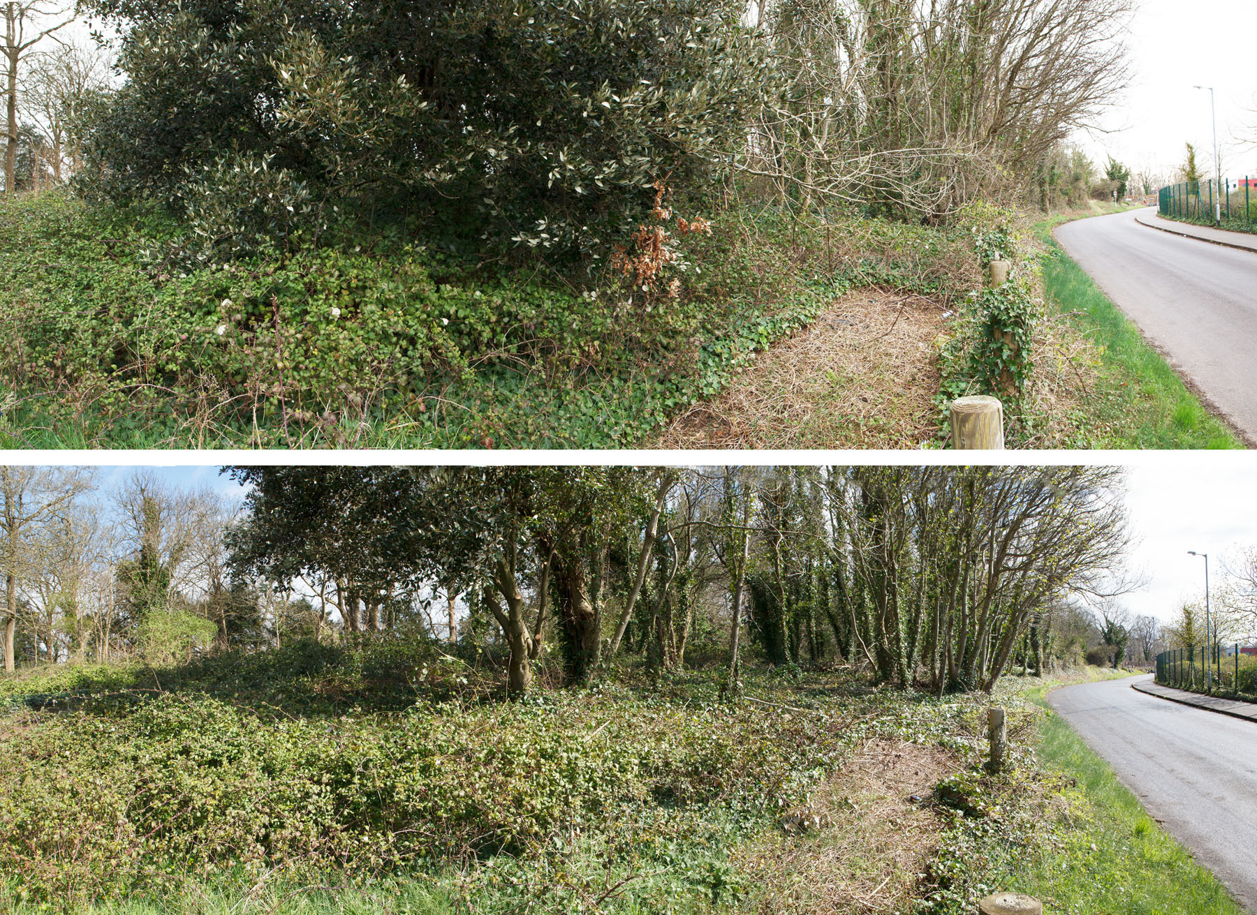
While the other volunteers work away in the woods a couple deal with the verge.
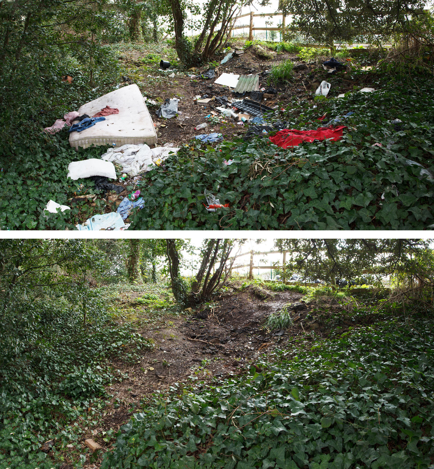
KWAG hasn’t often got involved in litter collection across the estate as we know there are locals and walkers who often do this, and the Probation service continue to carry out community service collections. However, one area has been a persistent pain: the layby on Penpole Lane. This regularly gets fly-tipped and the Council have recently erected a timber fence to try and inhibit illegal dumping. This, unfortunately, hasn’t worked, and one of last month’s working party aims was to clear the old quarry areas of rubbish.
The flytipped area before and after work.
We found it in a poor state, with binbags, and loose waste strewn about as well as the ubiquitous used mattress! We had a great turnout for the event, so good that it only took just a couple of hours to bag-up everything and leave it for collection in the layby. Unfortunately, just a fortnight later, more flytipping had been dumped in the same area. This has also been cleared away and we aim to keep monitoring the area.
Thank you to everyone who came out to and contributed to one of our best ever attended sessions, especially the new faces who came to join working party efforts.
…and some tree trimming
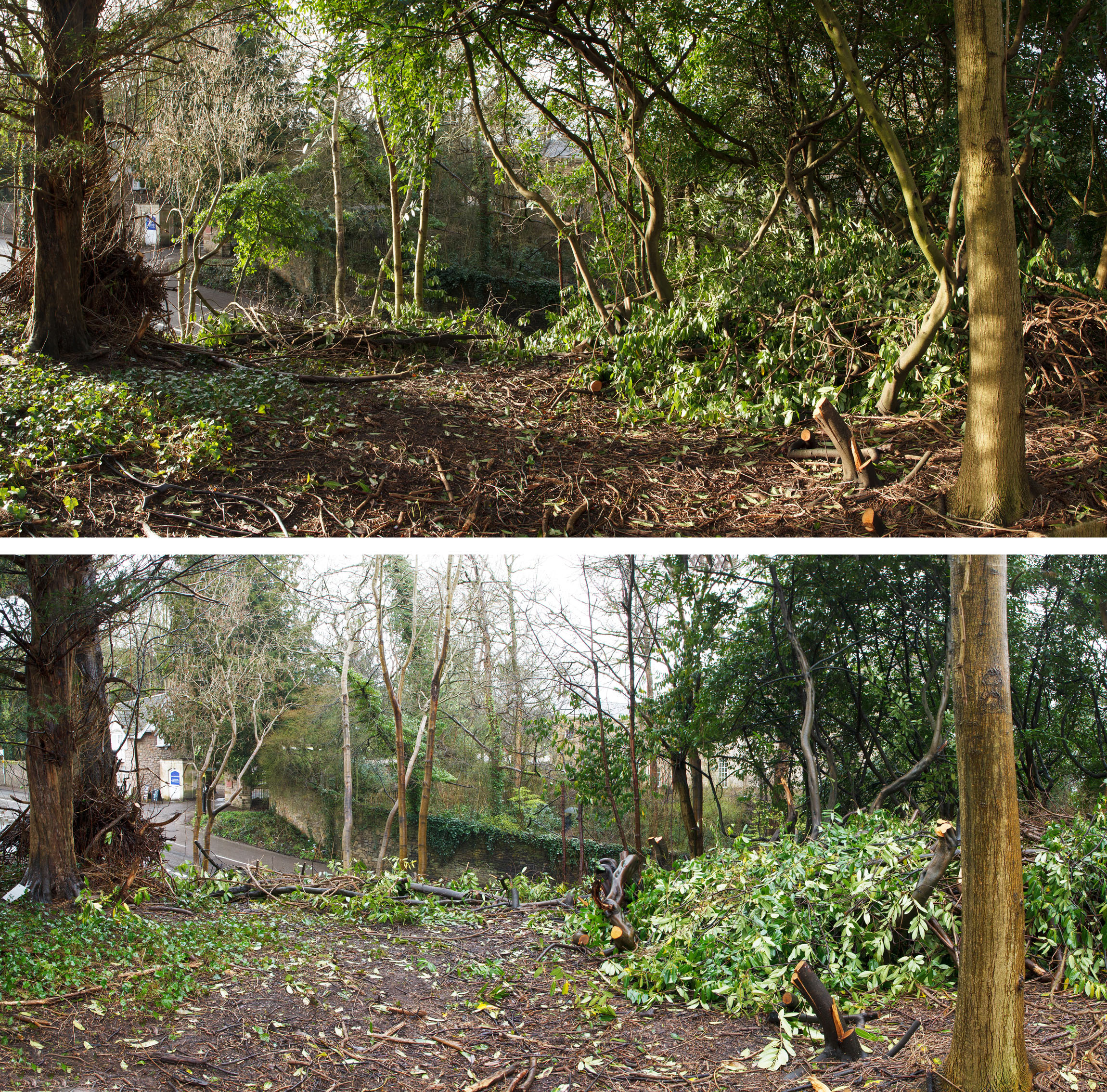
The second target for volunteers on our Working Party was a scrubby area alongside Penpole Lane, not far from the litter collection. Since the 1960s this area, once grassland, had been colonised by ash and sycamore. Most is in a poor condition, being multi-stemmed, damaged by cutting in the early years of their growth. Having persevered through many probable attempts to keep on top of them they have grown into a thicket along the roadside.
Looking south along Penpole lane showing the impact of recent work.
Our plans were to undertake “natural spacing” or “haloing” to thin out this area, cutting out the weedier and less healthy saplings to allow the better specimens to thrive. This has the secondary advantage of opening up glimpsed views from the main path along Penpole Point to the hills of Somerset to the west. From an historical perspective, these were once greatly admired by visitors to the estate.
Working carefully, warry of bird nesting season, we threaded through the copse gradually felling small saplings and raising the crown to allow sunlight in. Whilst the impact of the work might not be immediately obvious, it has helped open the area up and should prevent the further encroachment of scrub onto the remaining meadowland.
Looking across the area from the path to Penpole Point.
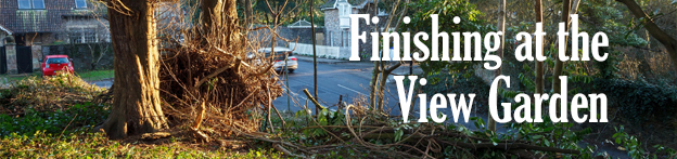
Volunteers concluded work on the old View Garden in February, with a final tidying-up of the laurels and woodland, and a focus on preparation for wildflower meadow planting. We undertook natural spacing with the woodland area, selecting the most viable saplings and shoots of trees and clearing around them to allow them to thrive in the future. This woodland management technique is the same as we started with the Forestry Commission in Penpole Wood in about 2015 and should ensure strong growth and positive regeneration of the woodland floor. We hope that this area, the glasshouse wall and verge, is back as it was when we last passed through in 2016.
incredible to think that it’s just been seven years since the glasshouse wall was last cleared by KWAG volunteers.
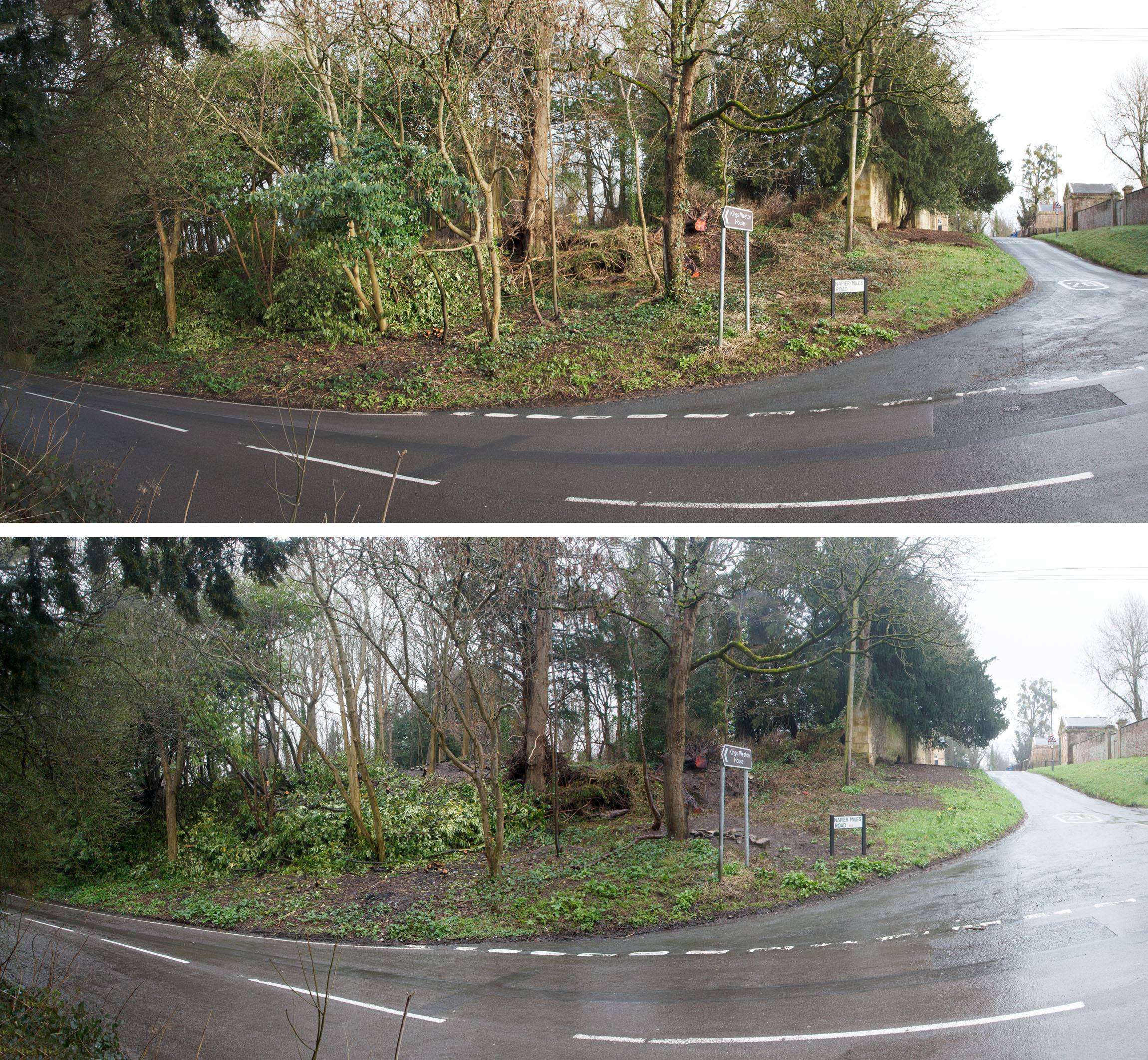
A few stray laurels were felled to complete work at the corner of Kings Weston Lane and Napier Miles Road, whilst around half of the volunteers took to digging out the roots of brambles long the verges. This will be critical in ensuring that the wildflower seeding planned for the end of this month has the best chance of thriving. We’re grateful to our regular volunteer Mike, who has undertaken to return week after week to get on top of the job and organised the specification and funding for the seeding project.
A couple more cherry laurels are cleared back from the edgeThe view from Kings Weston Lane showing the removal of laurels and the preparation work along Napier Miles Road, for the sowing of meadow seed.
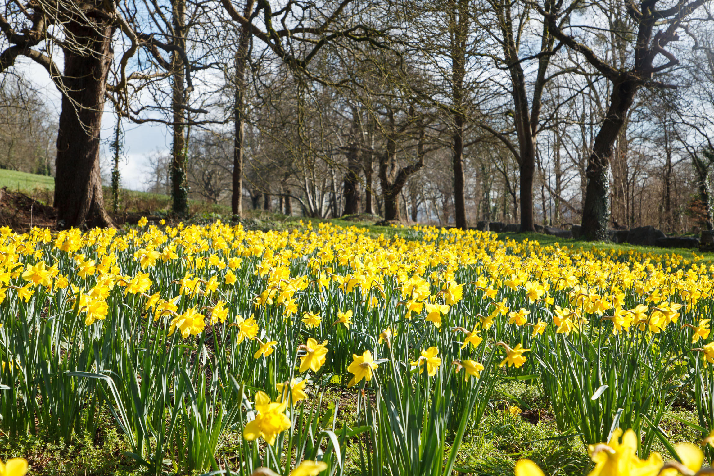
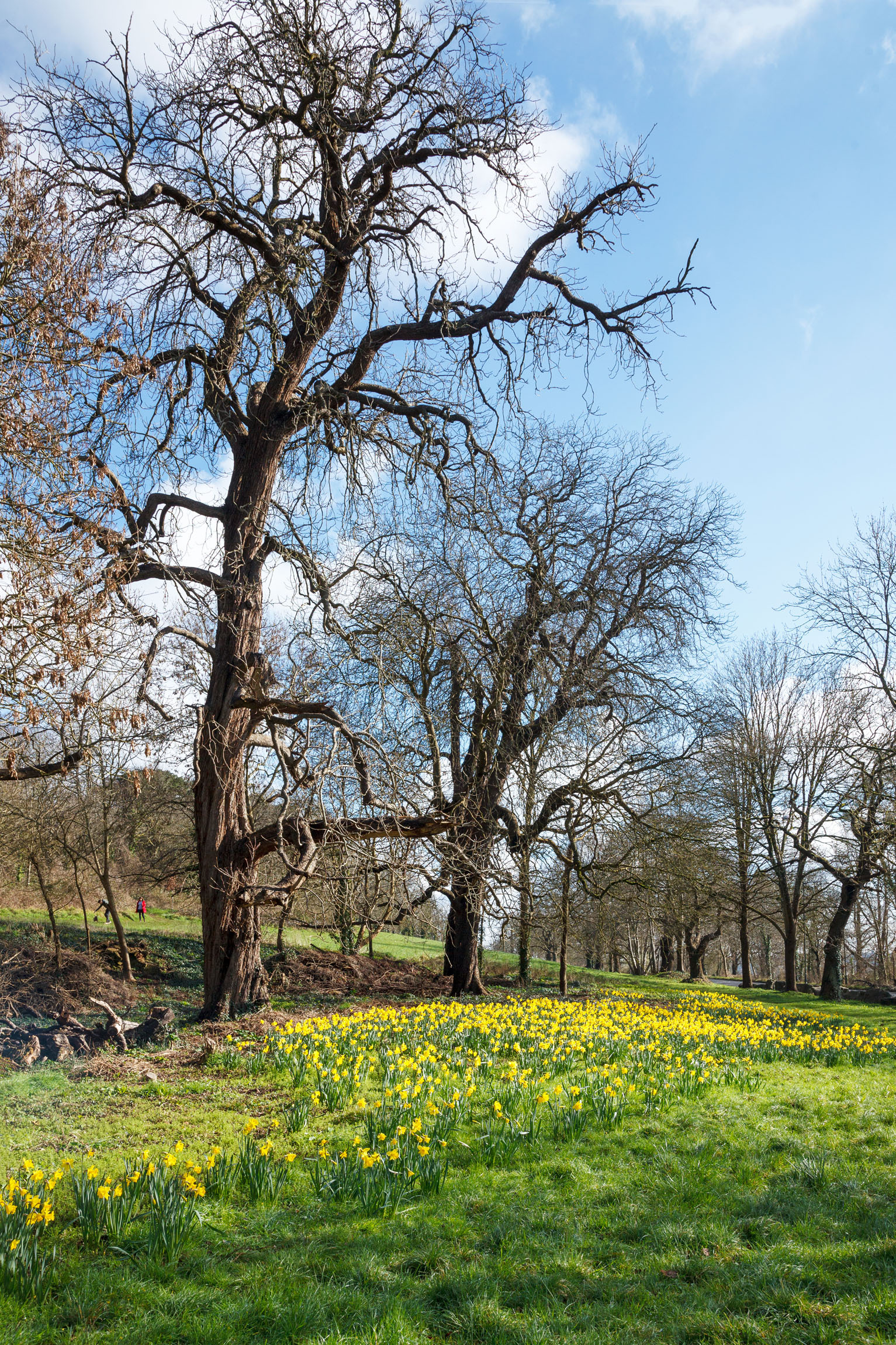
We’re delighted to share a couple of recent photos of the quarry grove alongside Shirehampton Road, the site of October’s Big Bulb Plant. The daffodils volunteers planted have bloomed early and were in full flower last week when a rare day of sun showcased them to full effect. The impact has been pretty incredible, particularly when seen from passing vehicles on the road. A big thank you to everyone who helped out and made this such a success!
The host of gold along the edge of the quarry grove on Shirehampton Road Just last year this was engulfed in brambles and the trees were unnoticeable.
This month our regular working party update takes the form of a report on the archaeological exploration volunteers undertook in the View Garden in January. This will be just a summary, our full report gives much greater background and detail on what we discovered.
At the start of the year KWAG identified four areas for investigation in the View Garden, the area of the walled gardens to the north of Napier Miles Road. Our ambitions were to understand more about some lost garden structures and their appearance. Just behind the gateway into the area from the east was a raised bank coinciding with the location of a small building at the head of a long axial path on the historic Ordnance Survey maps. A few well-aimed kicks at the ivy had shown there to be something here, but only a concerted effort might uncover more. The location of Bewy’s Cross was entirely lost, and it was impossible to visualise where it once stood. Here then, was another target for exploration: to locate the location on the ground. Finally, two areas of the woodland floor where ornamental stonework stubbornly clung on were likely the sites of two sets of steps set out along the axial path heading in the direction of a former viewing point at the far west of the garden. The two sites together offered a good opportunity to get a glimpse of the intended ornamental aspirations of the garden’s creators.
Our ambition has been simply to uncover and record rather than to make more invasive investigations into lower levels, adding “flesh to the bones” of the Victorian era gardens, giving them a new and amplified significance as part of the Grade II Listed Registered Historic Landscape.
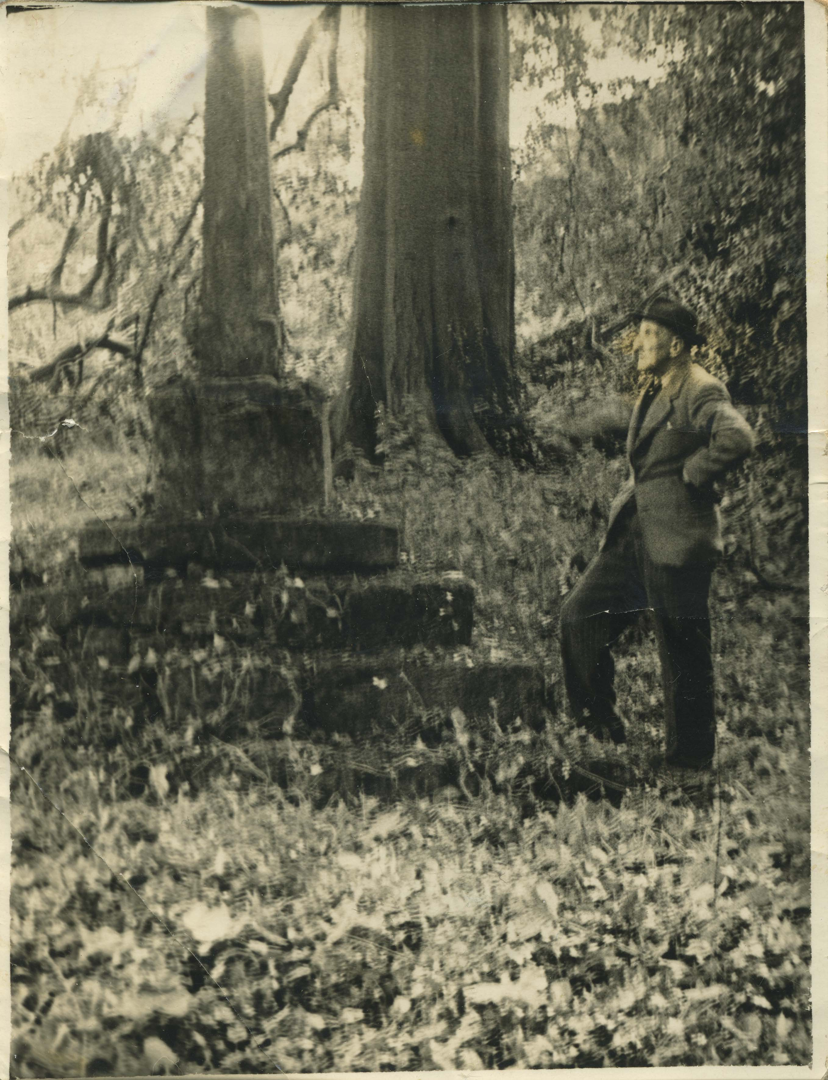
Mr Elms stands resting against Bewy’s Cross in 1950, shortly before it was dismantled and moved.
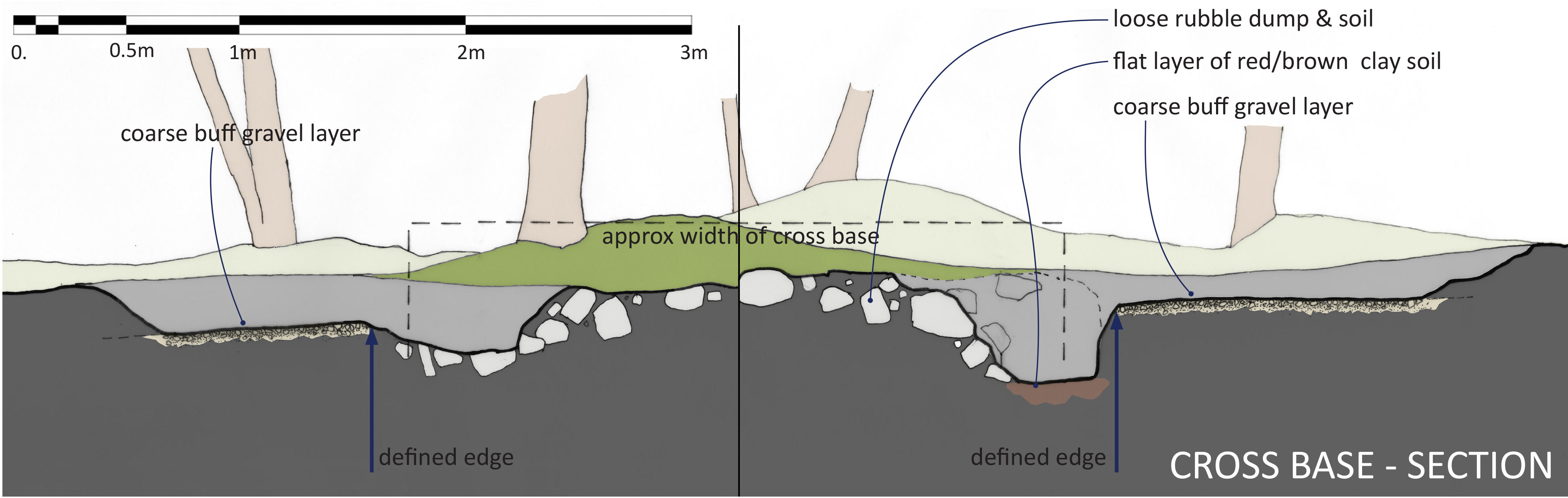
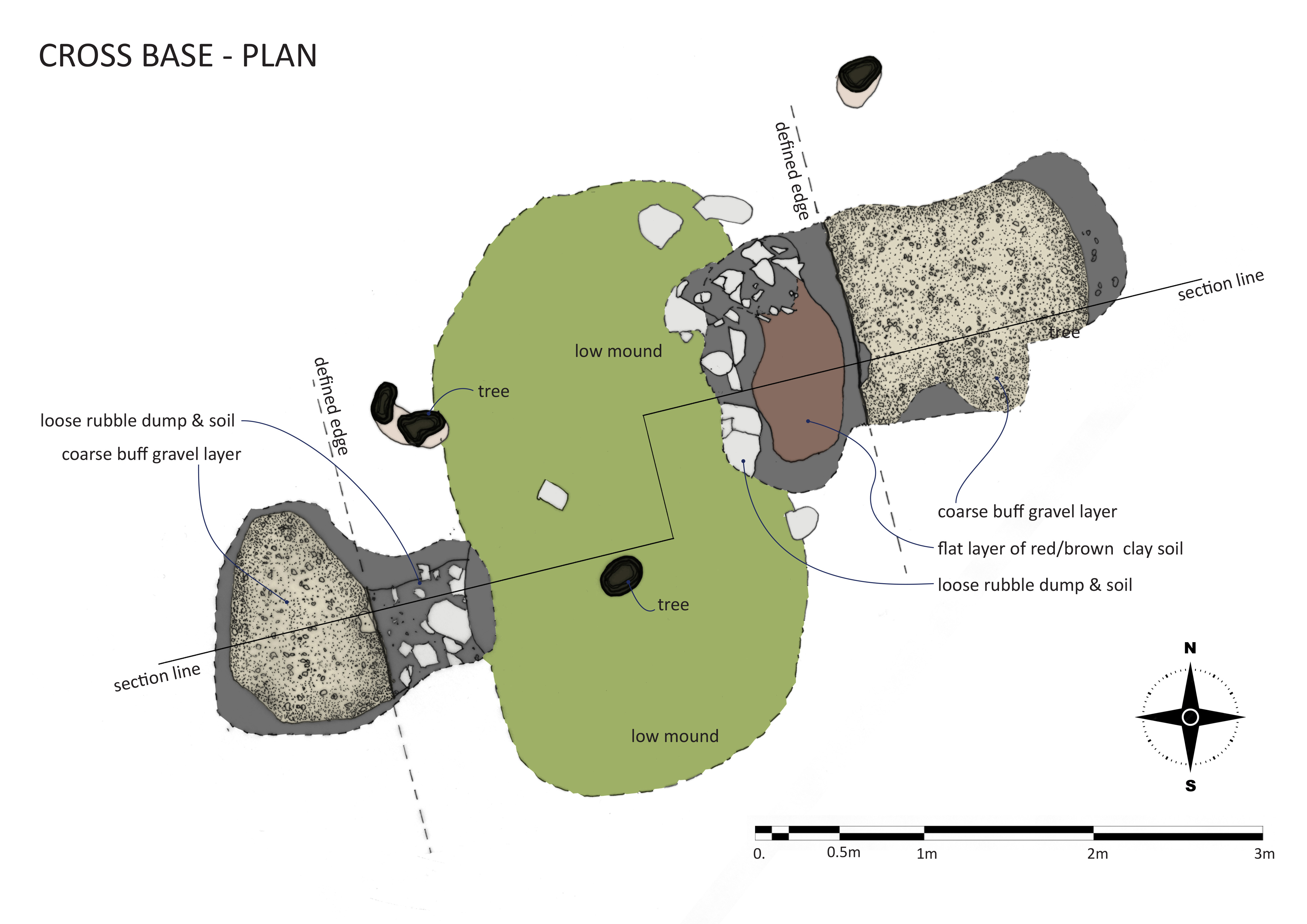
Bewy’s Cross: The week before the work started a new photo was discovered in Bristol Archives. Showing the site in 1950 the figure posing on the steps of the cross is Mr W T H Elms, Avonmouth Churchwarden, who had freshly uncovered the cross by pulling ivy off. This was undertaken as part of the final, ultimately unsuccessful, campaign to have the cross moved to the churchyard in Avonmouth. This is the only known photograph of the cross in its View Garden location, but so little recognisable detail in the background made it difficult to pinpoint where the cross had stood. Instead, we relied on a rough measurement taken from the historic maps, a small raised area with a number of self-seeded sycamore trees surrounding it. Digging quickly revealed a regular gravel surface just 6 inches below the ground.. this was matched on the other side of the small mound by another gravel surface. When excavated further, both these areas terminated at pronounced edges running parallel to each other and demarking an area about 10ft 9inches between them. Digging down further in the eastern trench this clean edge continued beneath the gravel, bottoming-out 11inches at a hard flat reddish-brown clay surface assumed to be the natural earth. The area between the two surfaces was characterised by lots of loose rubble stone and dark mulchy earth.
A cross-section of the excavation.
We can be confident from the location and alignments that the gravel surfaces are likely to be the garden paths shown on the 1884 map that once ran around the cross. The space between them was where the cross was removed in about 1952, and the rubble infill probably to level the site again afterwards. Sadly, there was no other evidence that could help date when the cross first came to the gardens, and no sign of any earlier structures. The dig here has identified the location and orientation of the Cross within the View Garden, shown how the paths around it were simply formed around it, and provided answers on how it was left after removal. Finding the exact location has assisted in understanding how it related to other features, particularly the rockery to the east which was encountered as a feature along the path culminating at the cross. It may be that evidence of foundations, dating evidence, or of the features survive beneath the rubble stone pile, but the likelihood is that everything was removed.
Scale drawing of the excavations around the site of the lost cross.
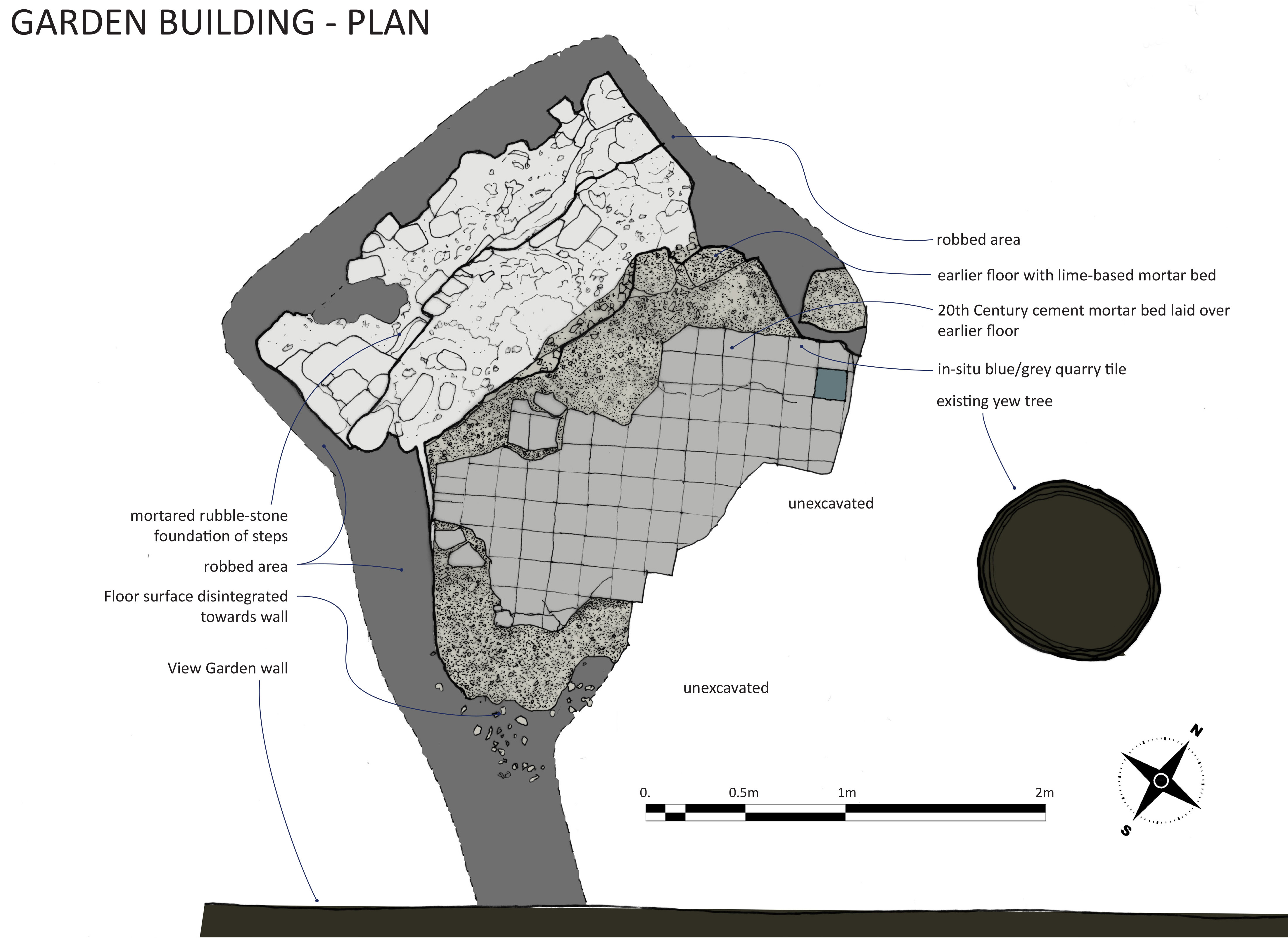
The Garden Building: The garden building is the most complex and enigmatic of the structures explored as part of our dig. There’s scant documentary evidence for it, the only record of it having existed at all being three consecutive editions of the Ordnance Survey map between 1884 and 1916. These show it was a small structure set close against the Georgian wall defining the east of the garden, and at the head of a long formal path, since vanished. The site remained as a pronounced bank just to the east of the Georgian gate piers, and between two mature yew trees. An idle poke about ahead of December’s working party identified the potential for the survival of structures here, and its significance at the head of the axial path through the garden indicated it was of some importance in the garden design.
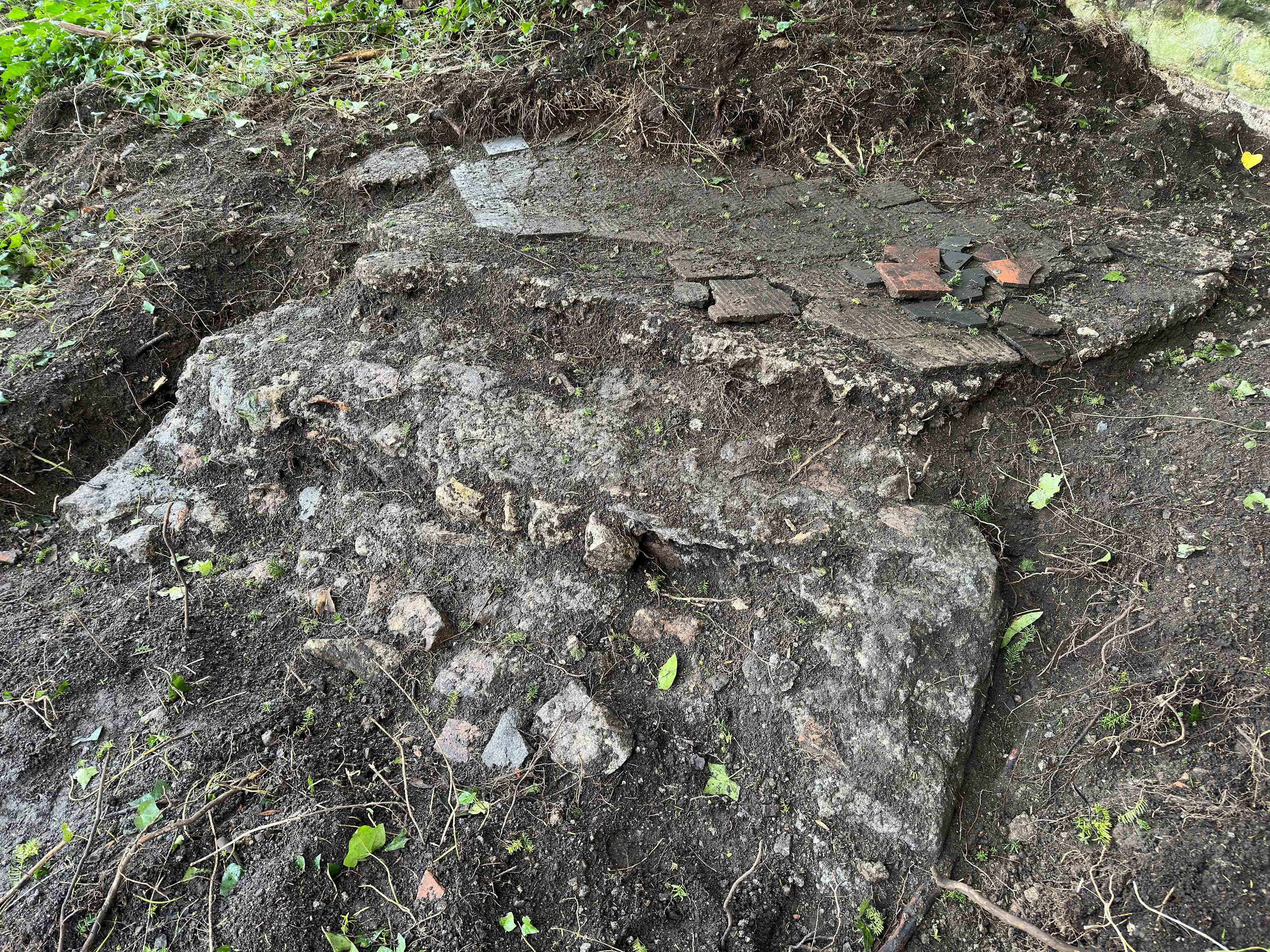
The foundations of the garden building with the steps in the foreground and the floor platform beyond.
The excavations identified the base of the with a monolithic stone and mortar feature forming the foundation of steps once aligned to the axial path, and a raised platform behind it from where an excellent view could be had down the length of the garden. The floor was laid with a lime mortar base of about 4 inches in depth, and later topped with a thin cement layer in which the pattern of tiles remained. The platform was laid on poor foundations and apparently directly onto the earth mound that ran along the Georgian Garden wall at this point. It has subsided to the rear and disintegrated closer to the wall. The remains delineated a square area roughly 7ft 4 inches wide, but sharply angled to the steps with a chamfered edge against them.
Excavations around the edges of both steps and floor platform provided no evidence of side walls or foundations for them, only loose infill not unlike the surrounding garden soils. The lack of foundations and roof or wall debris poses a puzzle. There are two possible explanations: Firstly, whatever superstructure there was may have been dismantled and taken away in its entirety, maybe for sale or reuse elsewhere. The very poor condition of the monolithic step base shows that the original stair treds and risers have been removed with considerable effort. These would likely have been of high-quality hard-wearing stone that had monetary value to whoever took them. Had the walls of the building been of high-quality materials these may also have succumbed to the salvage man, but this would not fully explain why no obvious foundations could be identified during excavation, there was no evidence of a systematic demolition process.
Measured plan of the garden building foundations
The other possibility is that the building was fabricated from timber and other organic materials; these would require a less substantial foundation and decay to nothing over time. Many garden buildings of the 18th and 19th Century were built in this way, with some making deliberate use of the rustic character of natural logs, boughs, bark, and thatch for picturesque effect. The slumping of the floor and disintegration of the edges could have begun early in the building’s history, without the support that more durable structures could have provided. The cement floor surface illustrates that efforts were made to repair the building at a time in the late 19th or early 20th Century when Portland cement became more commonplace. From the variation in thickness, the cement looks to have been applied as a levelling screed to compensate for the slumping floor level. Care appears to have been taken in the restoration, with the original floor tiles lifted and re-laid on the new surface. However, most of the subsidence should be attributed to a time following the building falling out of use and its walls and floors vanishing. The nearby yew tree may also have accelerated the disturbance of the structures.
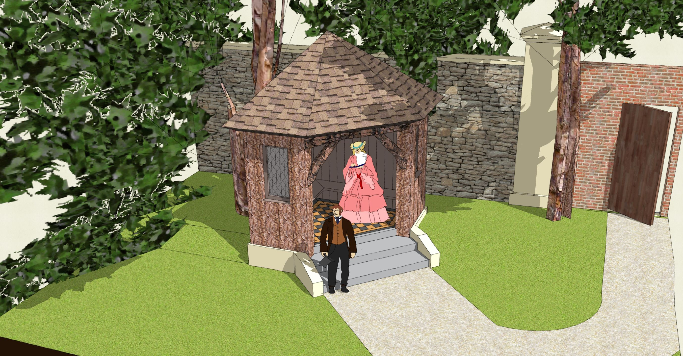
3D scale model of the garden building suggesting its appearance as based on the excavated remains.
With its dominant position raised up at the commencement of the axial path this building had a key role in the design of the View Garden. Its generally small size limits likely uses to which it could be put, so the likelihood is that it was a covered garden seat from which the Italian-style gardens could be enjoyed at leisure. It’s likely to have continued in use as part of the View Garden, “the gem of the whole garden”, until the first quarter of the 20th Century, after which it probably decayed and was abandoned. The removal and salvage of valuable materials is unlikely to have preceded the death of Sybil Napier Miles, who delighted in her gardens and maintained ownership of the area until her death in 1948.
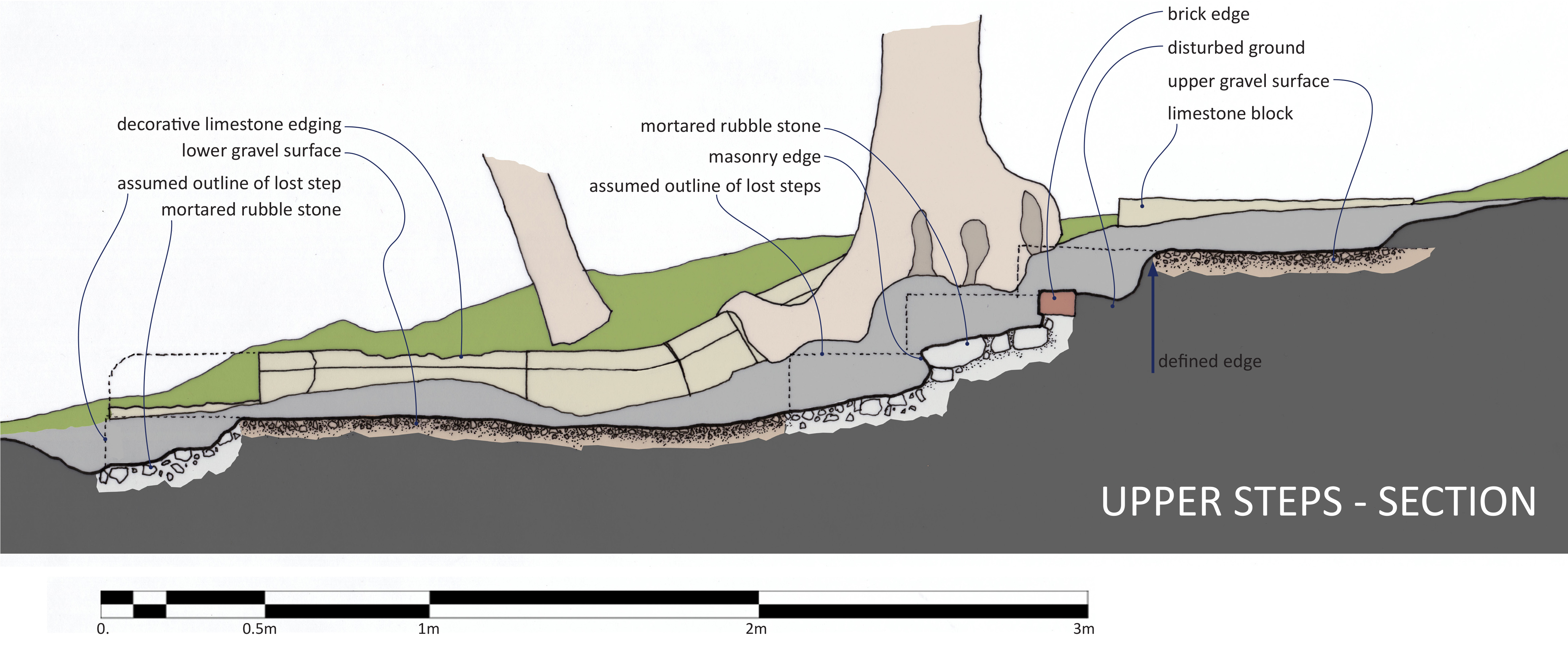
The steps:
Section of the decorative limestone edging, showing sockets and pegs in the end used to connect to the next section in the chain.
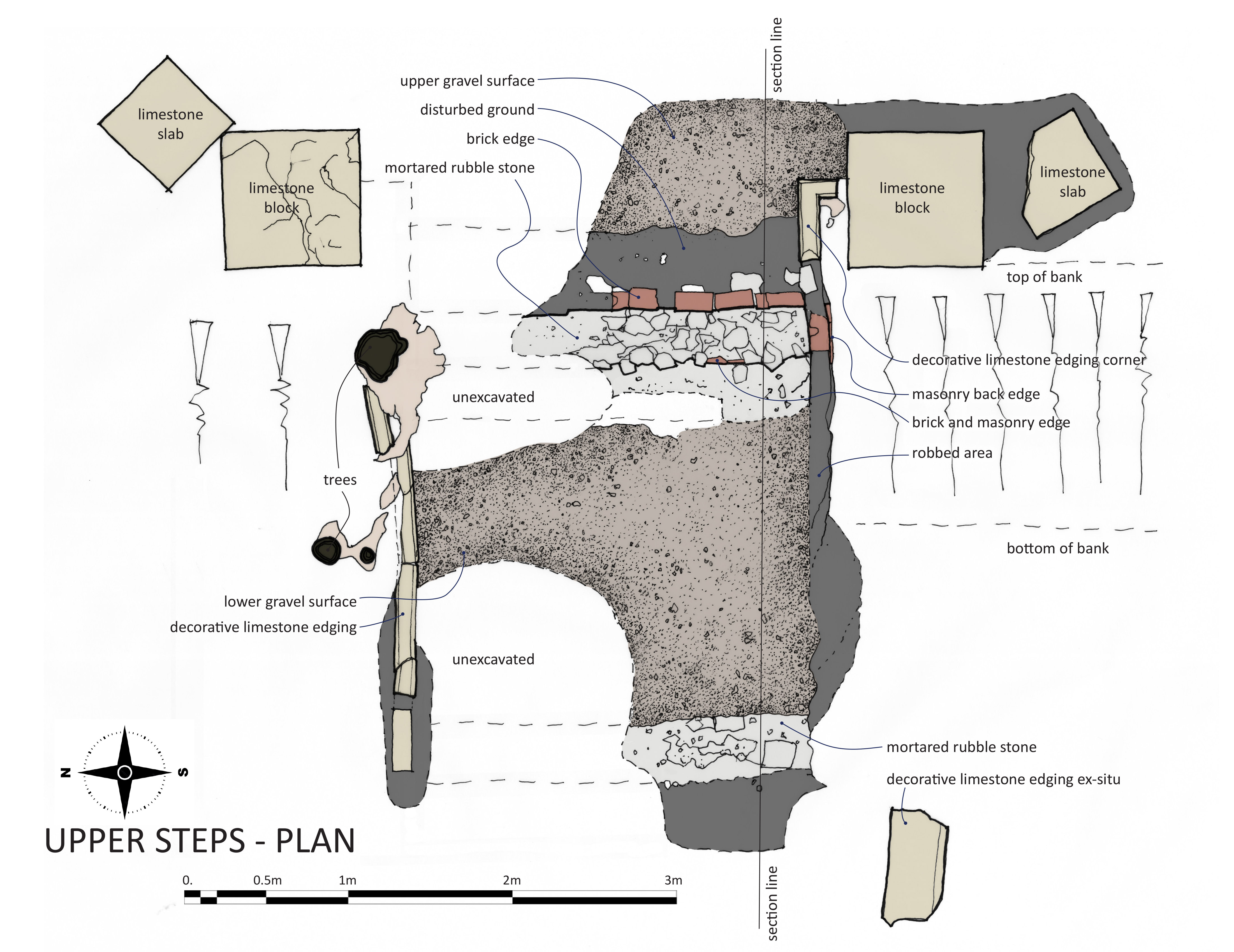
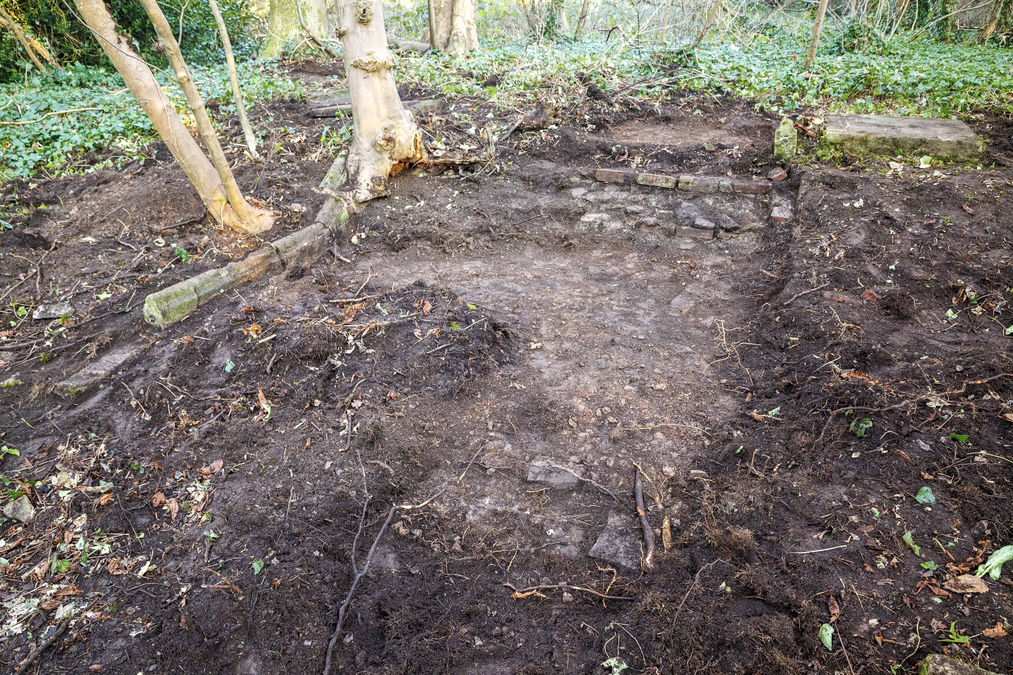
Two sets of steps appear on the Ordnance Survey maps set out towards the west end of the axial path through the garden. Fragments of masonry on the surface showing where volunteers should dig to uncover more. The lower set were heavily damaged and robbed-out, but the upper steps survived in better condition. Both sets provided important evidence of the intended appearance when built. Excavations at the upper steps revealed clear gravel surfaces at the top, and lower level, separated by roughly mortared brick and rubble stone foundations where three steps once descended. Another mortar area at the western end of this area, roughly in line with the end of the decorative edging, represented a final step set away from the main trio. The steps and gravel path were about 8ft 2inches wide, lined either end by decorative limestone edging stones. The edging was carved with a simple curved moulding. It had been robbed out almost entirely against the south side. Edging stones ran the length of all four steps, turning to terminate against a pair of limestone blocks at the top end. Beyond these blocks were further square stone slabs set at angles to the steps geometry.
Scale plan of the excavations at the upper steps.
The function of the limestone blocks is unclear. As found, with a smooth and level top surface, there were no indications that any of these blocks ever had any structure built upon them; Nor were any of the blocks of adequate depth to support anything of any scale or weight. Had they been the bases for garden urns or statues a degree of differential weathering would have been expected, highlighting the outline of any permanent feature stood upon them. The proximity of the Georgian glasshouse in the View Garden, the knowledge that the Miles Family took great pride in growing exotic plants, and the notion that the View Garden was set out as an Italianate garden, all suggest that these blocks could have formed seasonal platforms for the display of tender potted plants or citrus trees.
Looking east across the upper steps. The two levels of gravel path surface can be seen separated by the brick and rubble stone steps. Decorative edging survives on the left and the stone blocks are visible at the very top. A cross-section showing the excavated features.
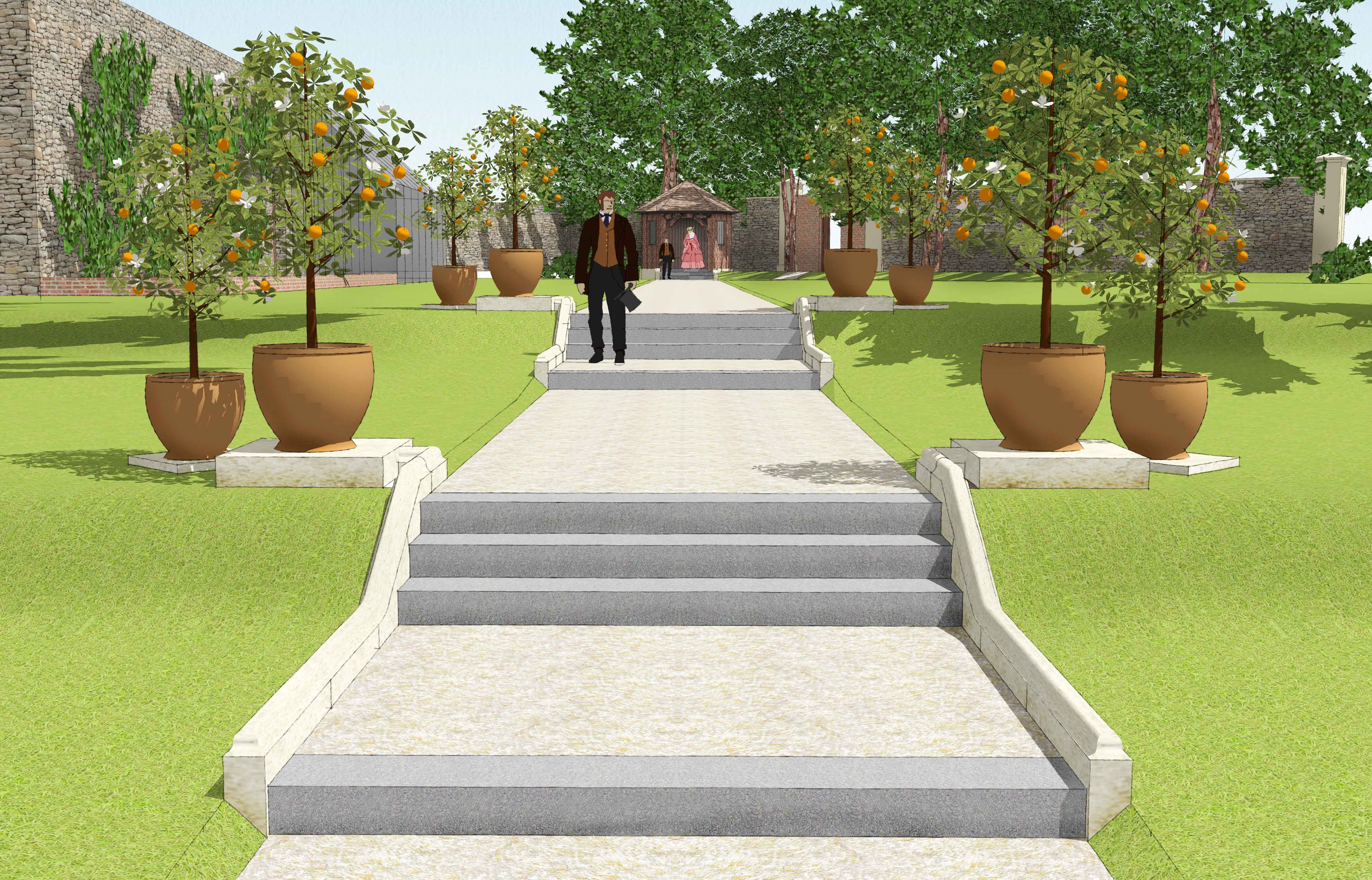
The lower set of steps was of the same design. The edging here showed an elegant curve to the design at the bottom of the set of three steps. Evidence for the actual steps came exclusively from this set. A few fragments of pennant stone remained following theft and damage in about 2011, but enough to understand the character and dimensions of the large stones. The evidence uncovered allows us to make an accurate reconstruction of the two sets of steps. Remains indicate the View Garden was laid out to a high quality design, requiring the use of expensive materials and significant building work. They show the importance of the axial path through the gardens, adding emphasis to the viewpoint found at its western end and the lost building at its east. The importance of the viewpoint, the raison d’etre of the garden, has been largely lost by the gradual growth of trees obscuring the views once celebrated. The design of the garden and other anecdotal evidence suggests that it was laid out in the 1860s. It incorporated the existing Georgian walls and glasshouse, and Bewy’s Cross into its design, adding the new formal path to focus attention on views. One reference to this as an “Italian” garden would fit the Victorian obsession with the Italian Renaissance and the design features introduced at this period.
An impression of how the view along the axial path might once have appeared. The lower and upper steps are lined with potted citrus trees and in the distance the garden building presides over the whole scene.
Next month we’ll report on a few surface finds from the area, but if you can’t wait until then, you’ll find everything in the full report now available on our website If you’d like something more interactive, you can explore our 3D scans of the excavated areas:
Since WWII, until recent years, many people worried about the gradual decline of Kings Weston house and grounds during continued institutional use. No less so than when the building was in occupation By Bristol College of Science and technology. Initially moving departments from Ashley Down Campus in 1961, their plans for an extensive concrete campus and the change into a university caused local alarm, the scale of the planned facilities concerning even the Council Planning department. Eventually, resistance to the proposals meant the college were forced to look elsewhere for new premises, landing on a site outside Bath where Bath University was eventually founded.
However, not everyone at the college was oblivious to the importance of Kings Weston house. Appropriately enough, it was the architecture department that were installed under the headship of Professor Kenneth Panter. He was a man with the dedication and knowledge to begin restoration work on the building and reverse some of the vicissitudes inflicted on the place since 1938. Since that time the house had become a buildings site, before being hastily patched up for wartime occupation by the military. At the end of hostilities, it became the meanwhile home to Lawrence Weston a primary school. Neither of these temporary uses of the building had much care for the heritage features of the property. By 1961 it was described as “seedy and down-at heel”, with “tottery” chimneys and broken windows. The school had covered the mahogany doors with white paint, and the collection of paintings had been moved to the safety of the city Museum and Art Gallery.
the only photo found of Professor Panter posed in front of one of the fireplaces.
Professor Panter commissioned urgent works to halt decay, but perhaps the biggest challenge of his eight years with the house was repairing the famous skyline. The monumental chimney arcade had been dismantled between 1959 and 1960, the Ministry of Works having “agreed that the chimneys must be taken down because they are actually dangerous.” Scaffolding had been in position so long that it was “in danger of taking root”, was “festooned” around the remains of Vanbrugh’s chimney arcade.
Recognising the importance of the chimneys to Vanbrugh’s design, Panter secured public money to rebuild them. Finally, by September 1968 the press was able to report that a new Doulting stone arcade was being hoisted into place. Towards the end of the department’s time at Kings Weston, Professor Panter was able to proudly tour reporters round the restored building with 120 students filling its rooms. Many works had been undertaken so fastidiously that the efforts required could hardly be guessed at. The hanging staircase had new beams inserted imperceptibly to replace failed Victorian ones, the ceiling of the Saloon at the front of the house had been strengthened with steel beams threaded carefully through the historic fabric, and historic plasterwork was consolidated and pinned back to walls and ceilings.
A rare view of Kings Weston house without it’s famous chimneys. Painted by George Holloway, this must date to between 1960 and 1968 when the chimneys were rebuilt.
The newspaper reported the headless statue from the Echo had been retrieved and that the Professor was offering a reward for the student who succeeded in finding its lost head in the grounds.
As they toured the ongoing works, government minister Lord Kennet and Lord Hailes, chairman of the Historic Buildings Council, praised the school of architecture for their work to reinstate the chimney arcade. The school had spent more than £40,000 on works, £10,000 on the arcade alone, with the bulk of that having been secured from the HBC. This was Panter’s crowning achievement at Kings Weston. He continued with the architecture department when it moved to the new bath Campus in 1970 and the next organisation to occupy the house, Bristol Constabulary, were far less caring of the building.
We can’t find much more information about Professor Kenneth Panter and his efforts at Kings Weston. It’s a shame that, as someone so closely involved with protecting the house, his role is not better known. Naturally, there’s little evidence of his work left now, but that’s just what good restoration should be.
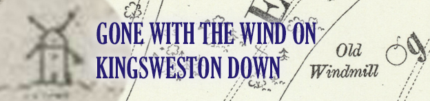
One historic feature of the estate remains shrouded in mystery: the lost windmill on Kingsweston Hill. By chance we rediscovered the remains on a recent walk across Kingsweston Hill, and they remain as a pronounced landscape feature. It’s often been mistaken for a burial mound, of which there are several across the hill, and occasionally as the remains of a Roman signal station or lighthouse.
The location of the old windmill on Kingsweston Hill in relation to other features.
The windmill shown on the 1720 estate plan with a roof and sails.
Already, by 1772, it was described as an ‘old’ windmill and is shown on the estate plan of that date standing just within the boundary of the Tithing of Kings Weston. The earliest reference to it appears to be from an earlier such plan from 1720 where it’s shown, perhaps emblematically, as a tower with a rounded top and four arms for sails, but, surely an “old” building would have stood for more than 50 years? Had it already fallen into disrepair by 1772? The origins of the building are unclear.
The remains surviving on the hill are now hidden somewhat by self-seeded trees that have scattered themselves across the site, but close inspection is worthwhile. There remains a significant mound with a hollow dip in the centre. Loose stonework sits half-buried around the remains and covered in ivy. The ring is about 7m in diameter and 1m in height, but the outline of the original building is likely to have been blurred by the walls falling outwards giving it a broader outline. It was clearly a circular masonry tower when first built.
It occupied a prominent and fittingly exposed location on the hill until trees grew up encroaching onto the open downland in the Nineteenth century. The wind coming up the Severn must have proven a regular if occasionally violent source of power. The mill had certainly fallen out of use by 1768 when a French Colonel was sent to spy on British interests. He recorded that the tower of the old mill was in use as a lookout in times of war, indeed, it was drafted into use for such in 1804 when a flagstaff was erected on it for signalling during the Napoleonic Wars.
The windmill is depicted punctuating the skyline of Kingsweston Hill in 1799. Blaise Castle is visible to the left of the foreground tree.
Several Georgian drawings and prints confirm that the tower remained to a substantial height and remained a significant feature, complementing the silhouette of Blaise Castle folly as an eyecatcher on the horizon. Perhaps its strategic military use ensured it was maintained at least as long as the country was threatened, but by about 1820 it vanishes. Its fate is as unclear as its origin; perhaps it was dismantled by the 22nd Lord de Clifford, robbed for its building material, or dismantled as a handy source of stone to burn in the nearby limekilns. Whatever happened to it, the surviving earthworks present an intriguing opportunity to excavate it and discover its secrets!
After it first featured in the popular BBC series in 2017, Kings Weston house again took a cameo role in the Doctor Who Christmas special last month. Much of the episode ‘The Church of Ruby Road’, the first full episode with new Doctor, Ncuti Gatwa, was filmed around Bristol, with the stair hall at Kings Weston the backdrop to a nasty accident involving Davina McCall and a Christmas tree. Fortunately, (spoilers) the Doctor returned through time to save her.
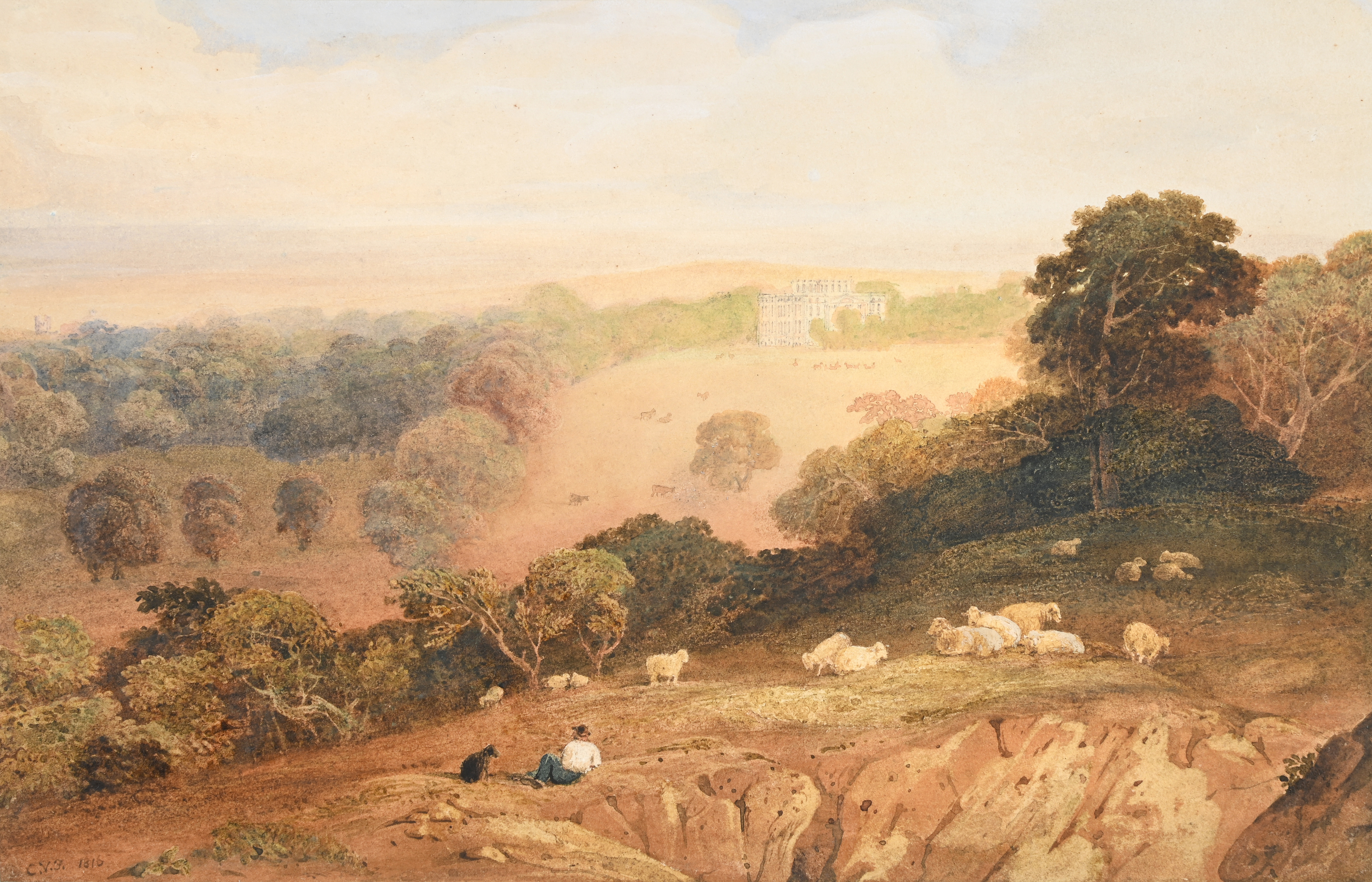
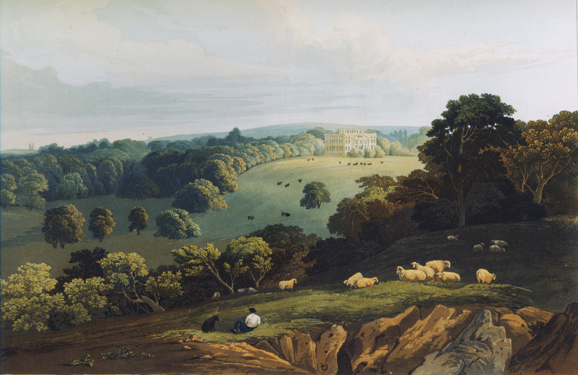
Another painting recently came to auction that’s of Kings Weston interest; it’s a watercolour of the house and park from Penpole Point. It’s a view that’s already familiar to us through one of the most widely published and most attractive prints of the park in the early 19th Century. The artist was the impressively named Anthony Vandyke Copley Fielding (1787-1855) who visited Kings Weston in 1816. It’s not clear whether it was intentionally painted as part of a larger project, but reproduced it found its way into a Series of Picturesque Views of Noblemen’s and Gentlemen’s Seats seven years later.
the original watercolour showing the view of Kings Weston house from Penpole Point. 1816, Anthony Vandyke Copley Fielding (1787-1855). One version of the print copied from the original painting.


