In error, we ordered far more daffodil bulbs than we anticipated ahead of our annual Big Bulb Plant in October. Instead of 7000, volunteers who came along had the challenge of getting 9000 bulbs into the ground. Matters were exasperated too, by the quality of the ground around the historic Kings Weston iron bridge where we’d committed to plant. Earlier this year, with the support of the Save the Green Iron Bridge group and Janet Poole., donations were collected as part of the celebrations around the reopening of the bridge, and it seemed fit to decorate either side of the structure with these flowers. When it came to it, this was easier said than done.
Work begins on the east side of the bridge with plenty of family involvement.
The event began at 10am and gradually volunteer numbers grew throughout the morning. Those tasked with digging holes for the bulbs immediately found the ground to be poor, filled, as it was, with rubble sat there from decades before. Both sides of the bridge were heavy going, large lumps of building stone, brick, tarmac and all manner of material dumped there for inexplicable reasons and buried beneath the turf. This considerably slowed progress throughout the day, particularly on the west side. We still don’t know where all this material came from, but it could have been demolition rubble from the WWII use of the estate or some well-meaning council plan to level the ground around the bridge.
By lunchtime, opportunities to plant on the eastern side were exhausted, and everyone moved over to support the beleaguered team on the west. Aside from the challenge of the ground conditions, the day was perfect for the task, breaking out in sunshine by the end of the day, helpfully illuminating the slopes of Shirehampton Park as it sank towards the horizon. Fine tilth of soil left by digging bramble roots out sped progress as the afternoon progressed, and work was completed with the trimming of some self-seeded saplings that might overshadow the newly planted area.
A big gang of volunteers moves gradually along the grass from the bridge. The western side of the iron bridge proved the biggest challenge to dig.
We’re immensely grateful for everyone who came along throughout the day, no matter how long they were able to help for. We hope that the daffodils will now find their own path and root well in the troublesome ground before next spring and give us a fine display. Whilst we didn’t manage to get the full compliment in the ground, 6500 bulbs made it in. The surplus will form the basis of this month’s working party and go in along Shirehampton Road.
Last month we reported on the ‘official’ opening of the Kings Weston Iron Bridge, but on Sunday 14th July the community celebration very much in the earlier event to shade! The event enjoyed a lovely sunny afternoon and attracted around 200 guests who were serenaded by the Bristol Ukulele Band as they gathered at the Kings Weston end of the bridge. Proceedings began with the 126th Scouts (Sea Mills) parading over the newly open bridge with their troop banners arriving in the informal arena at the west side.
Janet Poole receives flowers in thanks on behalf of KWAG. (Bob Pitchford)
Sea Mills Scouts parade their banners over the bridge.
Janet Poole, who has been so instrumental in promoting and championing the repair of the bridge took a stand on the newly finished steps and addressed the crowd. She undertook to thank everyone involved with the project including the construction workers and support from KWAG during the lengthy process getting it reinstated. In gratitude for her tireless work, KWAG’s chair presented a bouquet of flowers on behalf of everyone who’d missed the bridge over the last nine years. Finally a ribbon was strung between the railings and ceremonially cut to re-inaugurate the historic structure.
A collection held during the event raised £121 towards KWAG’s Big Bulb Plant this October, for planting of daffodils either side of the bridge. The bridge was in very active use during event, with many guests taking their first opportunity to cross the bridge in its new raised location. Louis, a twelve year old drummer, closed proceedings with a rousing session in the sun. At the generous invitation of John Barbey of Kings Weston house, many people sauntered back to the vaulted coffee shop where complementary drinks and cake rounded off a beautiful and memorable celebration, a fit conclusion to a long-running saga.
This month our regular working party update takes the form of a report on the archaeological exploration volunteers undertook in the View Garden in January. This will be just a summary, our full report gives much greater background and detail on what we discovered.
At the start of the year KWAG identified four areas for investigation in the View Garden, the area of the walled gardens to the north of Napier Miles Road. Our ambitions were to understand more about some lost garden structures and their appearance. Just behind the gateway into the area from the east was a raised bank coinciding with the location of a small building at the head of a long axial path on the historic Ordnance Survey maps. A few well-aimed kicks at the ivy had shown there to be something here, but only a concerted effort might uncover more. The location of Bewy’s Cross was entirely lost, and it was impossible to visualise where it once stood. Here then, was another target for exploration: to locate the location on the ground. Finally, two areas of the woodland floor where ornamental stonework stubbornly clung on were likely the sites of two sets of steps set out along the axial path heading in the direction of a former viewing point at the far west of the garden. The two sites together offered a good opportunity to get a glimpse of the intended ornamental aspirations of the garden’s creators.
Our ambition has been simply to uncover and record rather than to make more invasive investigations into lower levels, adding “flesh to the bones” of the Victorian era gardens, giving them a new and amplified significance as part of the Grade II Listed Registered Historic Landscape.
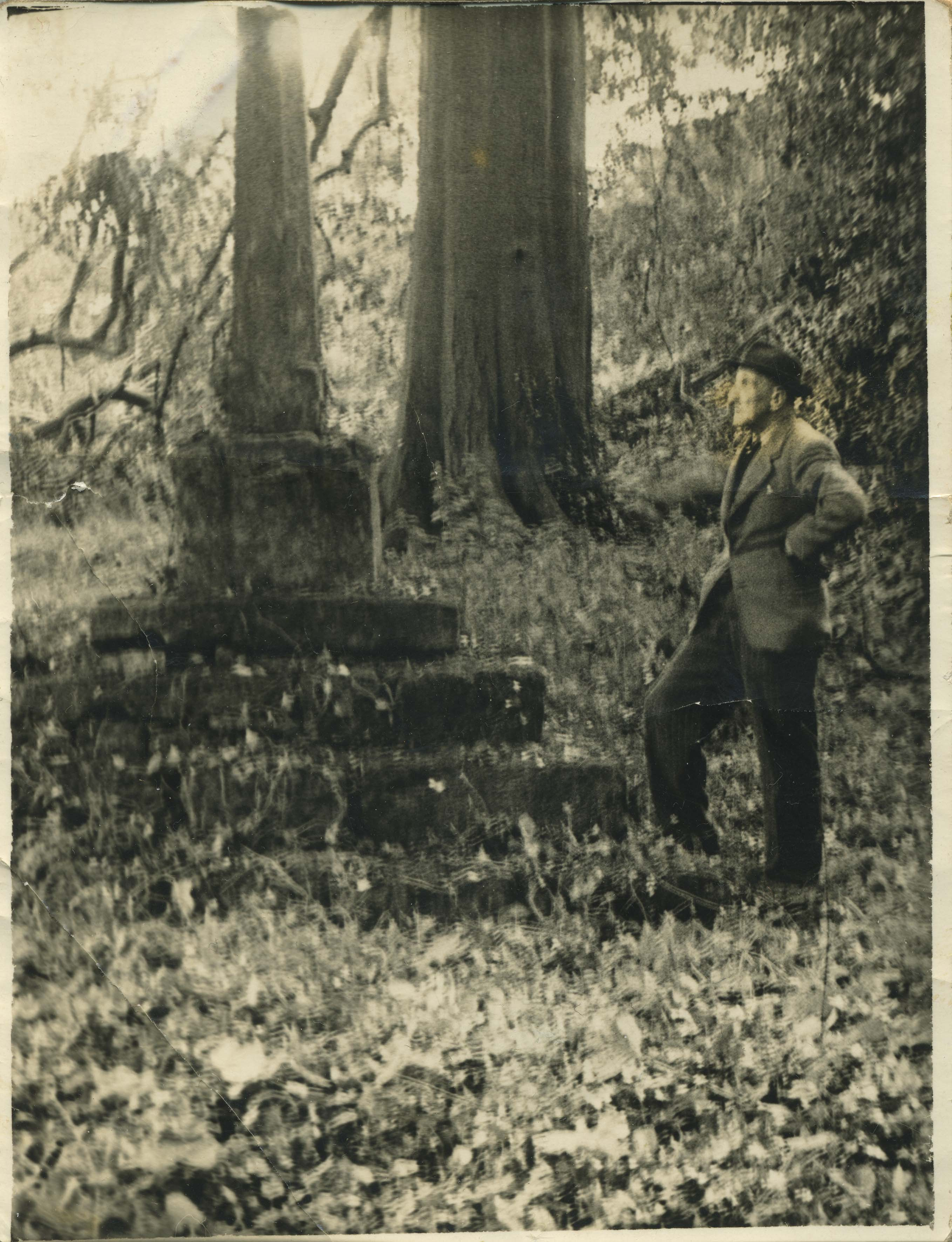
Mr Elms stands resting against Bewy’s Cross in 1950, shortly before it was dismantled and moved.
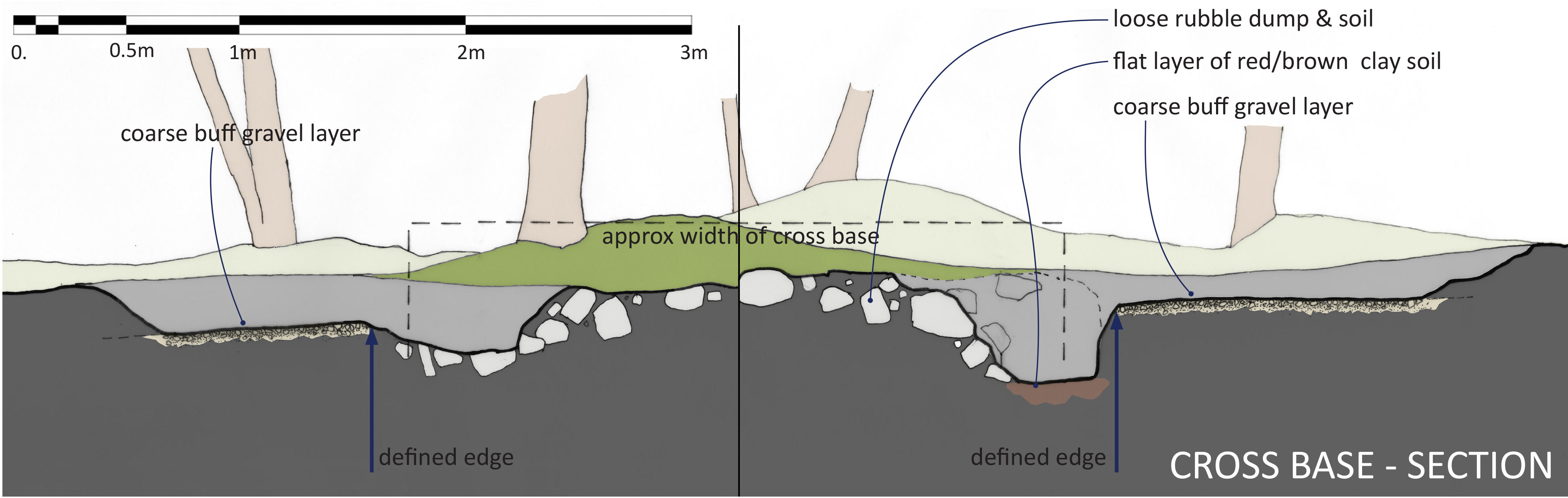
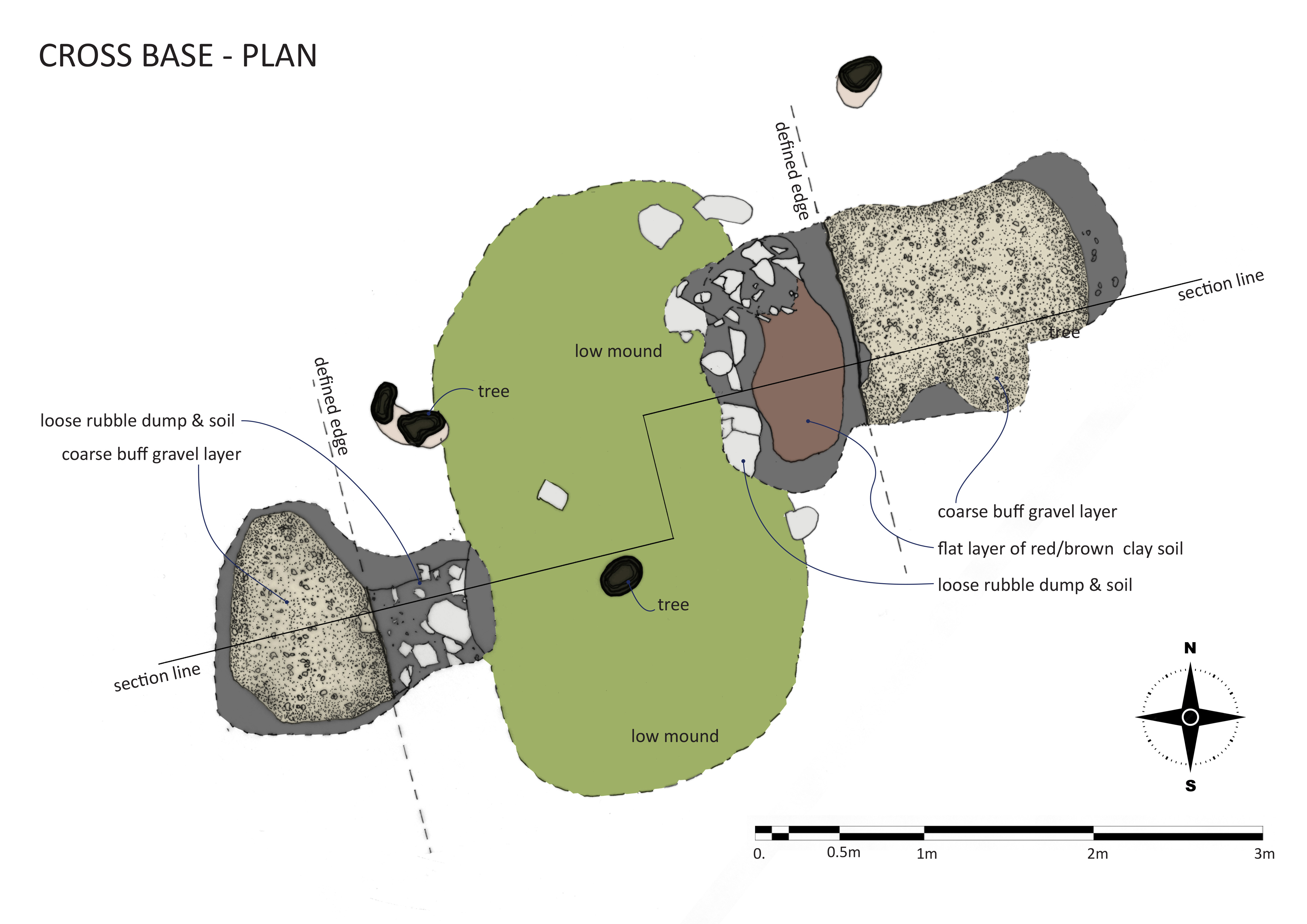
Bewy’s Cross: The week before the work started a new photo was discovered in Bristol Archives. Showing the site in 1950 the figure posing on the steps of the cross is Mr W T H Elms, Avonmouth Churchwarden, who had freshly uncovered the cross by pulling ivy off. This was undertaken as part of the final, ultimately unsuccessful, campaign to have the cross moved to the churchyard in Avonmouth. This is the only known photograph of the cross in its View Garden location, but so little recognisable detail in the background made it difficult to pinpoint where the cross had stood. Instead, we relied on a rough measurement taken from the historic maps, a small raised area with a number of self-seeded sycamore trees surrounding it. Digging quickly revealed a regular gravel surface just 6 inches below the ground.. this was matched on the other side of the small mound by another gravel surface. When excavated further, both these areas terminated at pronounced edges running parallel to each other and demarking an area about 10ft 9inches between them. Digging down further in the eastern trench this clean edge continued beneath the gravel, bottoming-out 11inches at a hard flat reddish-brown clay surface assumed to be the natural earth. The area between the two surfaces was characterised by lots of loose rubble stone and dark mulchy earth.
A cross-section of the excavation.
We can be confident from the location and alignments that the gravel surfaces are likely to be the garden paths shown on the 1884 map that once ran around the cross. The space between them was where the cross was removed in about 1952, and the rubble infill probably to level the site again afterwards. Sadly, there was no other evidence that could help date when the cross first came to the gardens, and no sign of any earlier structures. The dig here has identified the location and orientation of the Cross within the View Garden, shown how the paths around it were simply formed around it, and provided answers on how it was left after removal. Finding the exact location has assisted in understanding how it related to other features, particularly the rockery to the east which was encountered as a feature along the path culminating at the cross. It may be that evidence of foundations, dating evidence, or of the features survive beneath the rubble stone pile, but the likelihood is that everything was removed.
Scale drawing of the excavations around the site of the lost cross.
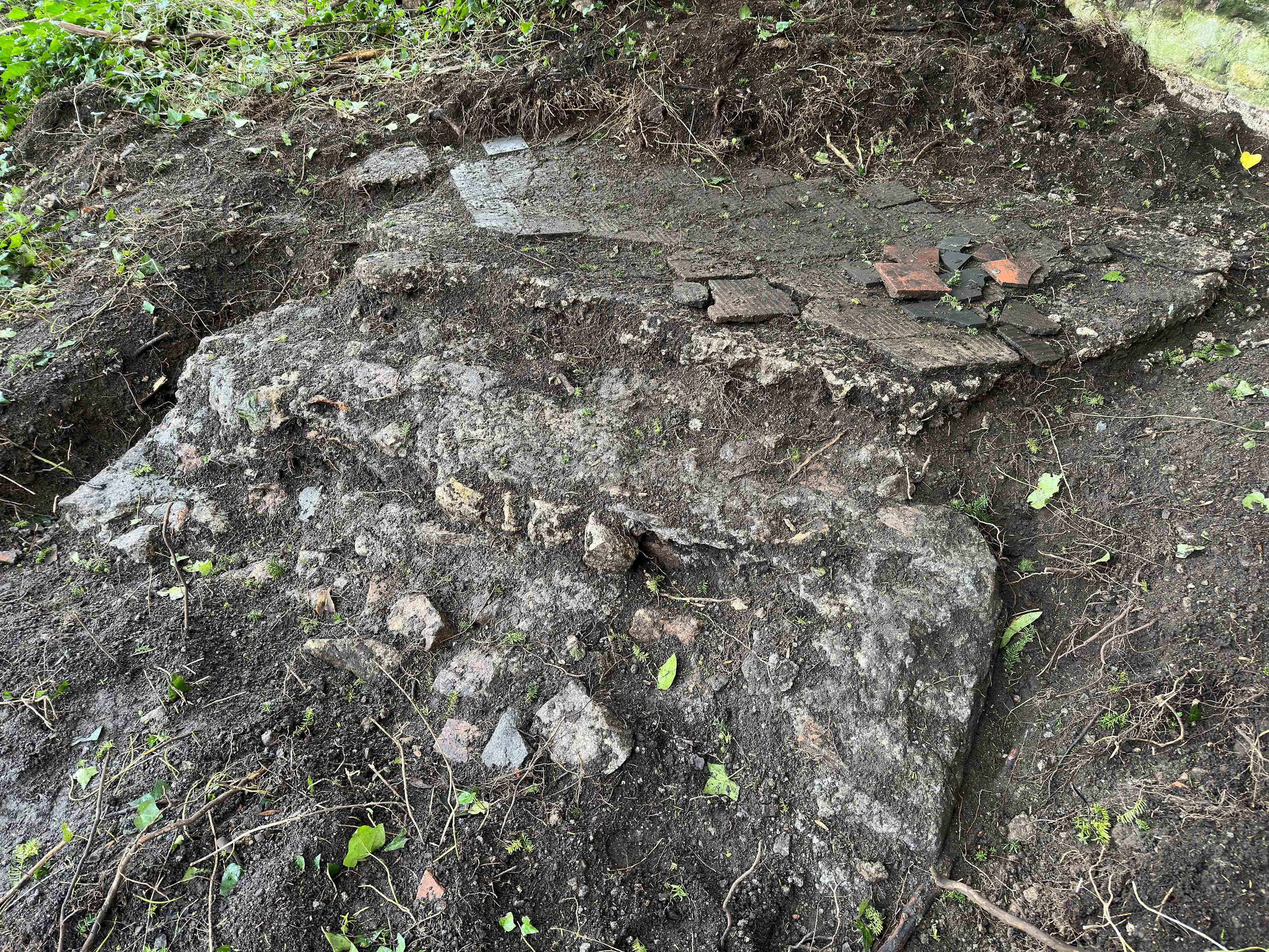
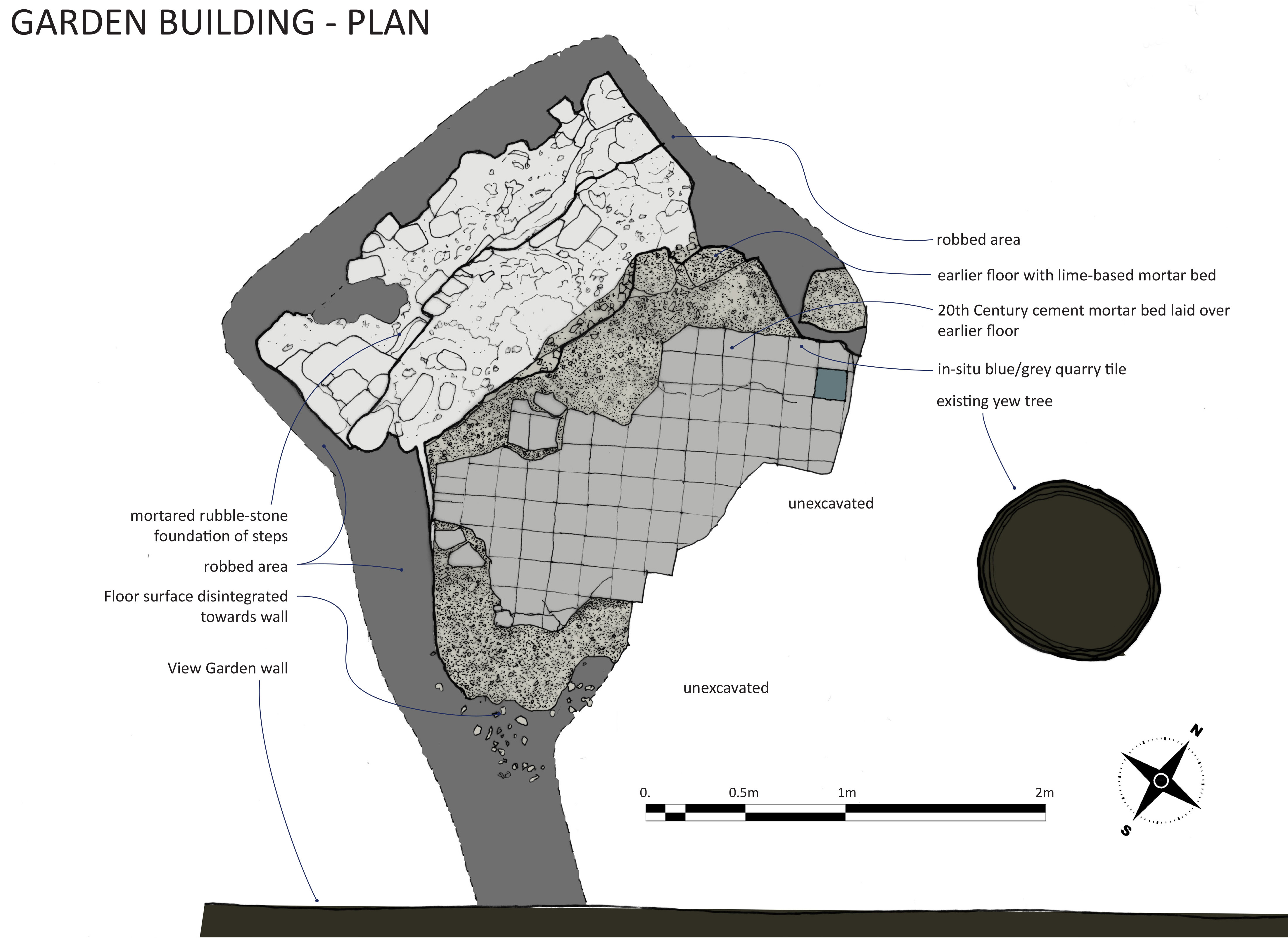
The Garden Building: The garden building is the most complex and enigmatic of the structures explored as part of our dig. There’s scant documentary evidence for it, the only record of it having existed at all being three consecutive editions of the Ordnance Survey map between 1884 and 1916. These show it was a small structure set close against the Georgian wall defining the east of the garden, and at the head of a long formal path, since vanished. The site remained as a pronounced bank just to the east of the Georgian gate piers, and between two mature yew trees. An idle poke about ahead of December’s working party identified the potential for the survival of structures here, and its significance at the head of the axial path through the garden indicated it was of some importance in the garden design.
The foundations of the garden building with the steps in the foreground and the floor platform beyond.
The excavations identified the base of the with a monolithic stone and mortar feature forming the foundation of steps once aligned to the axial path, and a raised platform behind it from where an excellent view could be had down the length of the garden. The floor was laid with a lime mortar base of about 4 inches in depth, and later topped with a thin cement layer in which the pattern of tiles remained. The platform was laid on poor foundations and apparently directly onto the earth mound that ran along the Georgian Garden wall at this point. It has subsided to the rear and disintegrated closer to the wall. The remains delineated a square area roughly 7ft 4 inches wide, but sharply angled to the steps with a chamfered edge against them.
Excavations around the edges of both steps and floor platform provided no evidence of side walls or foundations for them, only loose infill not unlike the surrounding garden soils. The lack of foundations and roof or wall debris poses a puzzle. There are two possible explanations: Firstly, whatever superstructure there was may have been dismantled and taken away in its entirety, maybe for sale or reuse elsewhere. The very poor condition of the monolithic step base shows that the original stair treds and risers have been removed with considerable effort. These would likely have been of high-quality hard-wearing stone that had monetary value to whoever took them. Had the walls of the building been of high-quality materials these may also have succumbed to the salvage man, but this would not fully explain why no obvious foundations could be identified during excavation, there was no evidence of a systematic demolition process.
Measured plan of the garden building foundations
The other possibility is that the building was fabricated from timber and other organic materials; these would require a less substantial foundation and decay to nothing over time. Many garden buildings of the 18th and 19th Century were built in this way, with some making deliberate use of the rustic character of natural logs, boughs, bark, and thatch for picturesque effect. The slumping of the floor and disintegration of the edges could have begun early in the building’s history, without the support that more durable structures could have provided. The cement floor surface illustrates that efforts were made to repair the building at a time in the late 19th or early 20th Century when Portland cement became more commonplace. From the variation in thickness, the cement looks to have been applied as a levelling screed to compensate for the slumping floor level. Care appears to have been taken in the restoration, with the original floor tiles lifted and re-laid on the new surface. However, most of the subsidence should be attributed to a time following the building falling out of use and its walls and floors vanishing. The nearby yew tree may also have accelerated the disturbance of the structures.
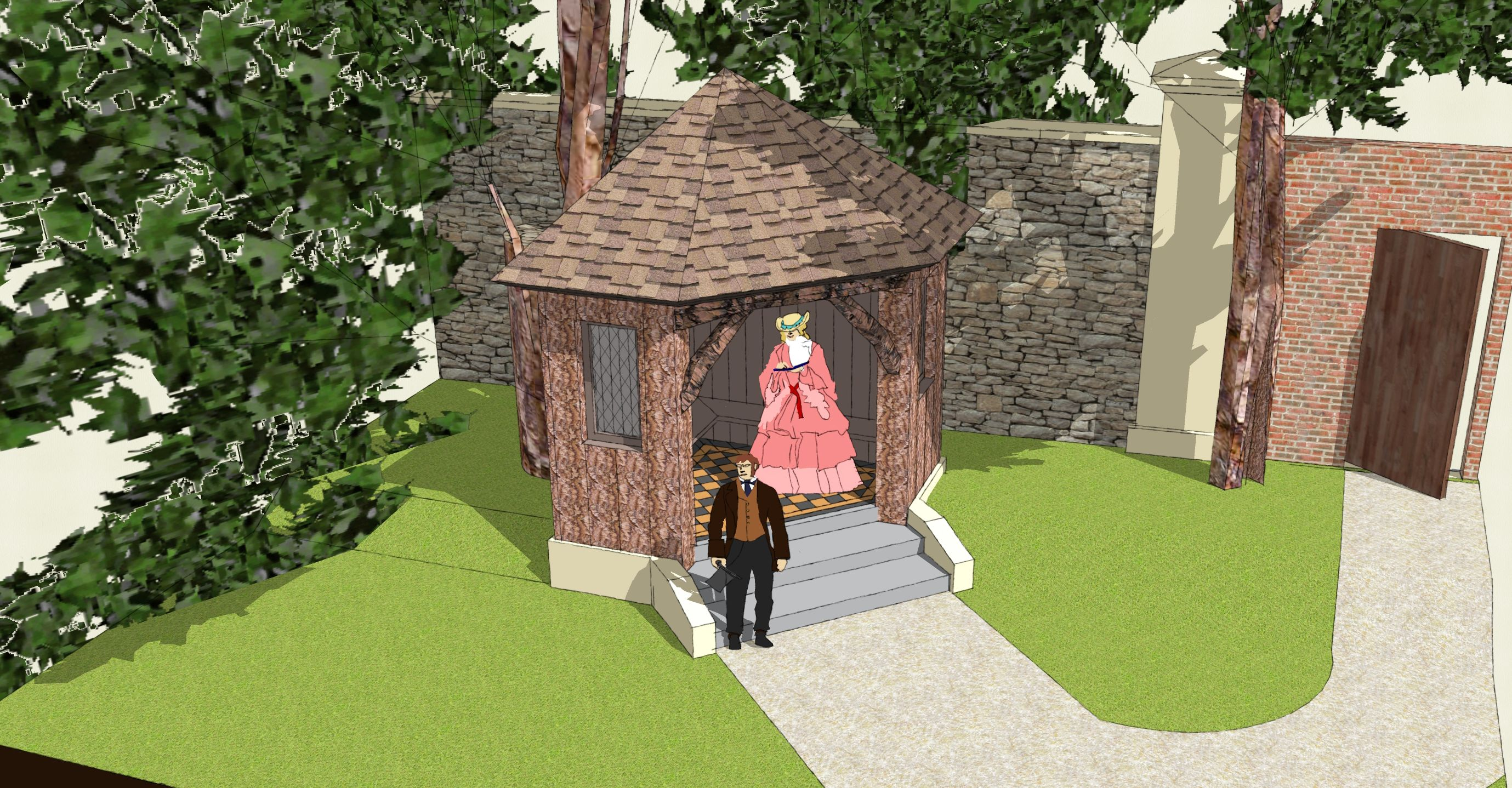
3D scale model of the garden building suggesting its appearance as based on the excavated remains.
With its dominant position raised up at the commencement of the axial path this building had a key role in the design of the View Garden. Its generally small size limits likely uses to which it could be put, so the likelihood is that it was a covered garden seat from which the Italian-style gardens could be enjoyed at leisure. It’s likely to have continued in use as part of the View Garden, “the gem of the whole garden”, until the first quarter of the 20th Century, after which it probably decayed and was abandoned. The removal and salvage of valuable materials is unlikely to have preceded the death of Sybil Napier Miles, who delighted in her gardens and maintained ownership of the area until her death in 1948.
The steps:
Section of the decorative limestone edging, showing sockets and pegs in the end used to connect to the next section in the chain.
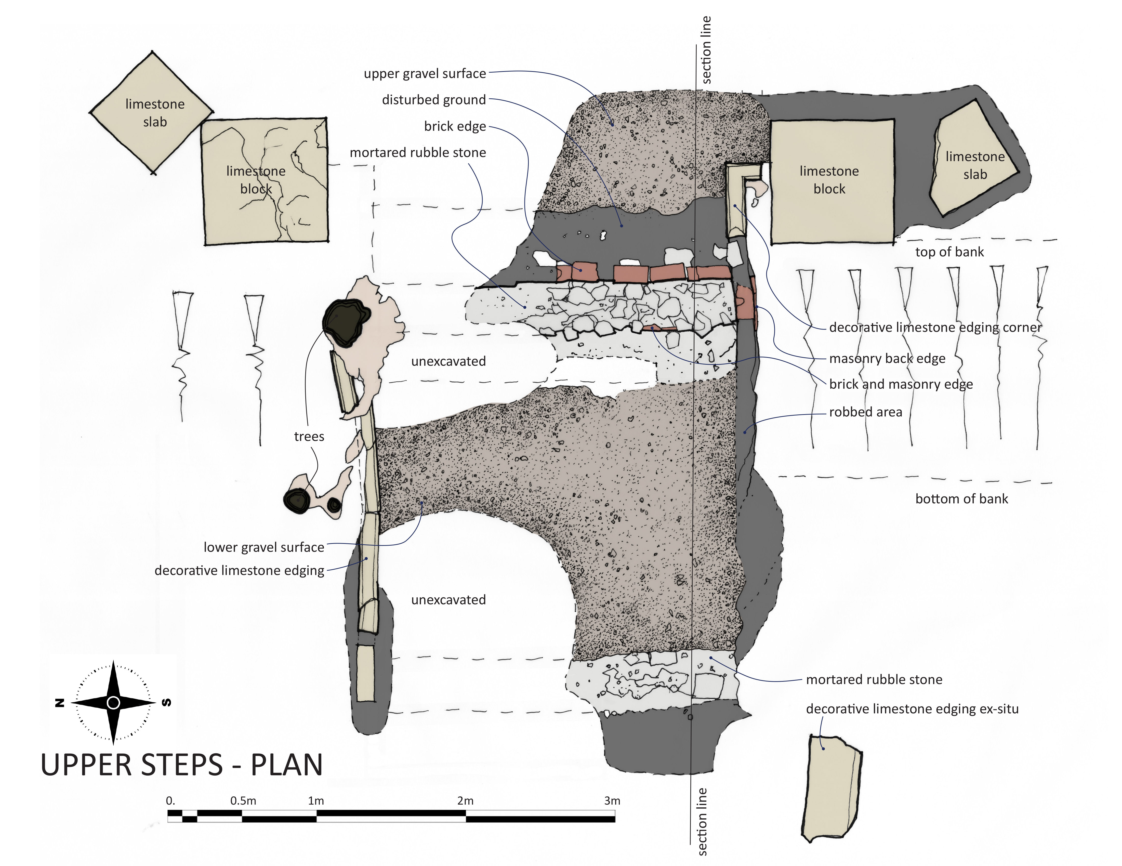
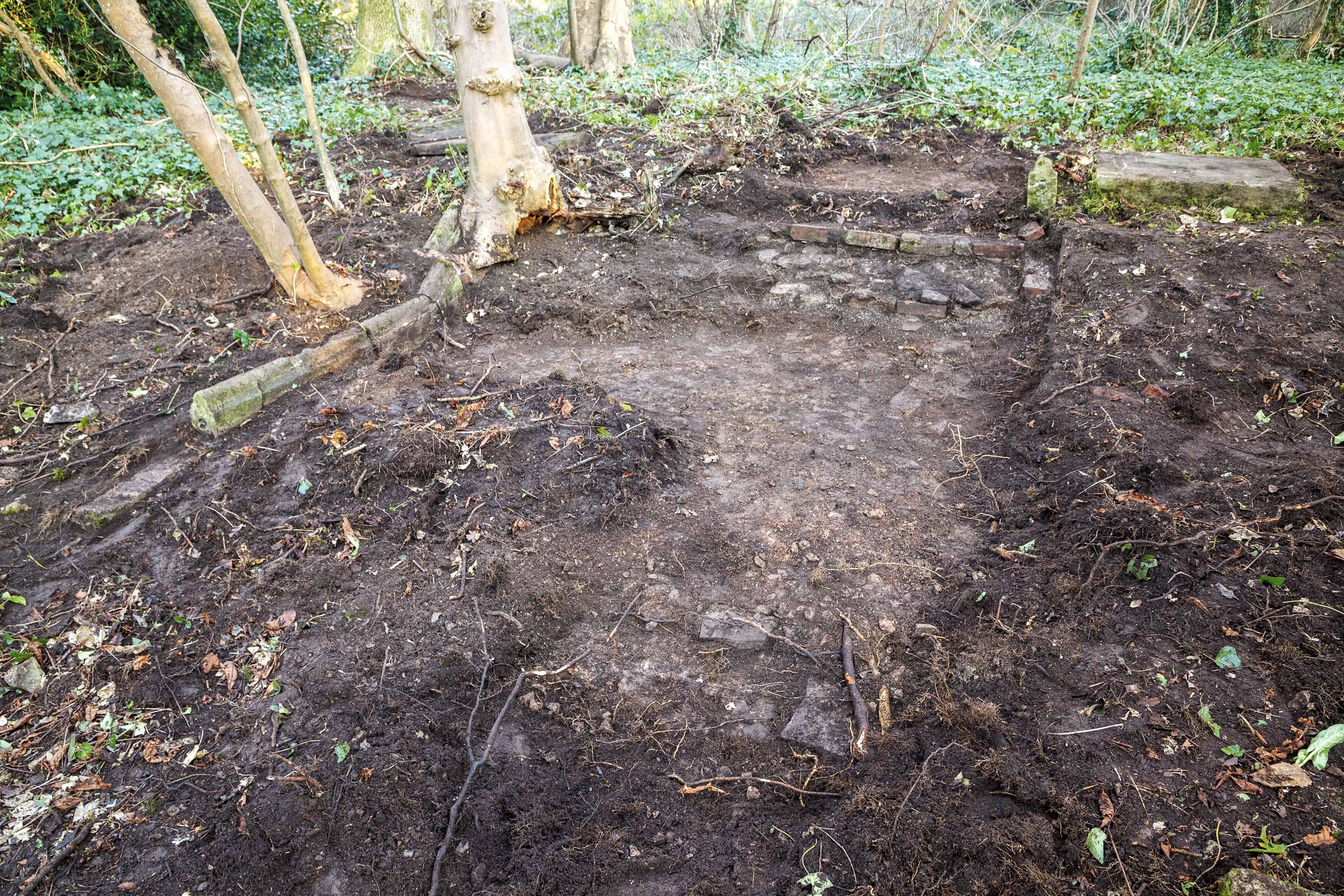
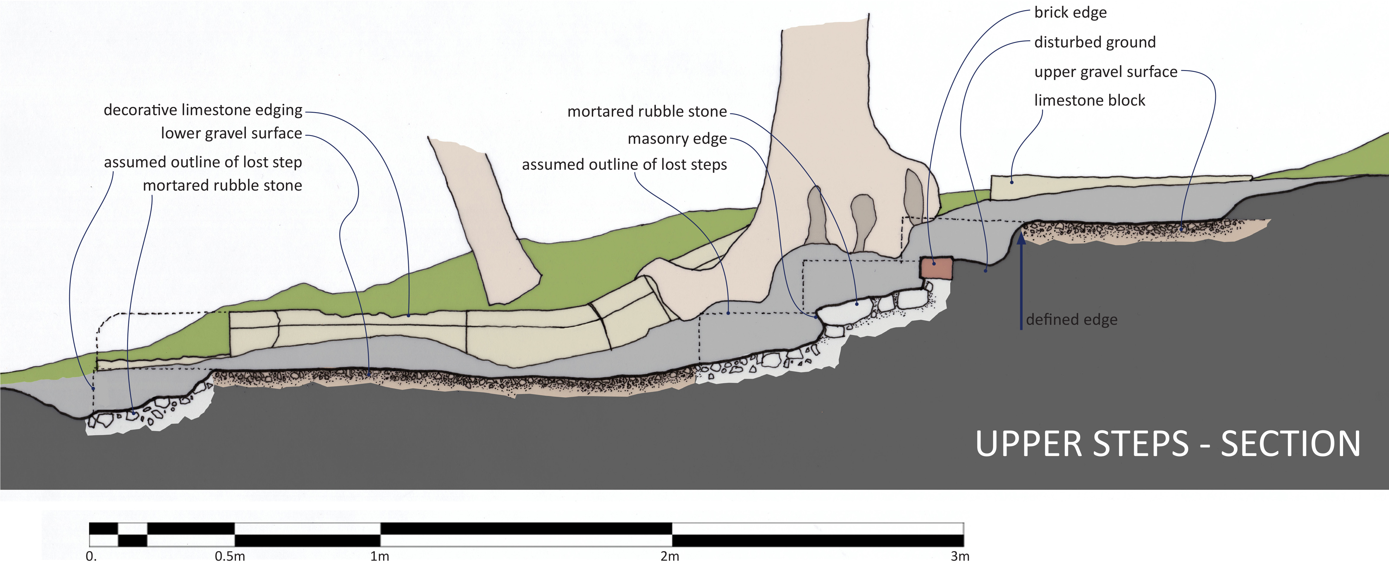
Two sets of steps appear on the Ordnance Survey maps set out towards the west end of the axial path through the garden. Fragments of masonry on the surface showing where volunteers should dig to uncover more. The lower set were heavily damaged and robbed-out, but the upper steps survived in better condition. Both sets provided important evidence of the intended appearance when built. Excavations at the upper steps revealed clear gravel surfaces at the top, and lower level, separated by roughly mortared brick and rubble stone foundations where three steps once descended. Another mortar area at the western end of this area, roughly in line with the end of the decorative edging, represented a final step set away from the main trio. The steps and gravel path were about 8ft 2inches wide, lined either end by decorative limestone edging stones. The edging was carved with a simple curved moulding. It had been robbed out almost entirely against the south side. Edging stones ran the length of all four steps, turning to terminate against a pair of limestone blocks at the top end. Beyond these blocks were further square stone slabs set at angles to the steps geometry.
Scale plan of the excavations at the upper steps.
The function of the limestone blocks is unclear. As found, with a smooth and level top surface, there were no indications that any of these blocks ever had any structure built upon them; Nor were any of the blocks of adequate depth to support anything of any scale or weight. Had they been the bases for garden urns or statues a degree of differential weathering would have been expected, highlighting the outline of any permanent feature stood upon them. The proximity of the Georgian glasshouse in the View Garden, the knowledge that the Miles Family took great pride in growing exotic plants, and the notion that the View Garden was set out as an Italianate garden, all suggest that these blocks could have formed seasonal platforms for the display of tender potted plants or citrus trees.
Looking east across the upper steps. The two levels of gravel path surface can be seen separated by the brick and rubble stone steps. Decorative edging survives on the left and the stone blocks are visible at the very top. A cross-section showing the excavated features.
The lower set of steps was of the same design. The edging here showed an elegant curve to the design at the bottom of the set of three steps. Evidence for the actual steps came exclusively from this set. A few fragments of pennant stone remained following theft and damage in about 2011, but enough to understand the character and dimensions of the large stones. The evidence uncovered allows us to make an accurate reconstruction of the two sets of steps. Remains indicate the View Garden was laid out to a high quality design, requiring the use of expensive materials and significant building work. They show the importance of the axial path through the gardens, adding emphasis to the viewpoint found at its western end and the lost building at its east. The importance of the viewpoint, the raison d’etre of the garden, has been largely lost by the gradual growth of trees obscuring the views once celebrated. The design of the garden and other anecdotal evidence suggests that it was laid out in the 1860s. It incorporated the existing Georgian walls and glasshouse, and Bewy’s Cross into its design, adding the new formal path to focus attention on views. One reference to this as an “Italian” garden would fit the Victorian obsession with the Italian Renaissance and the design features introduced at this period.
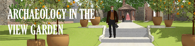
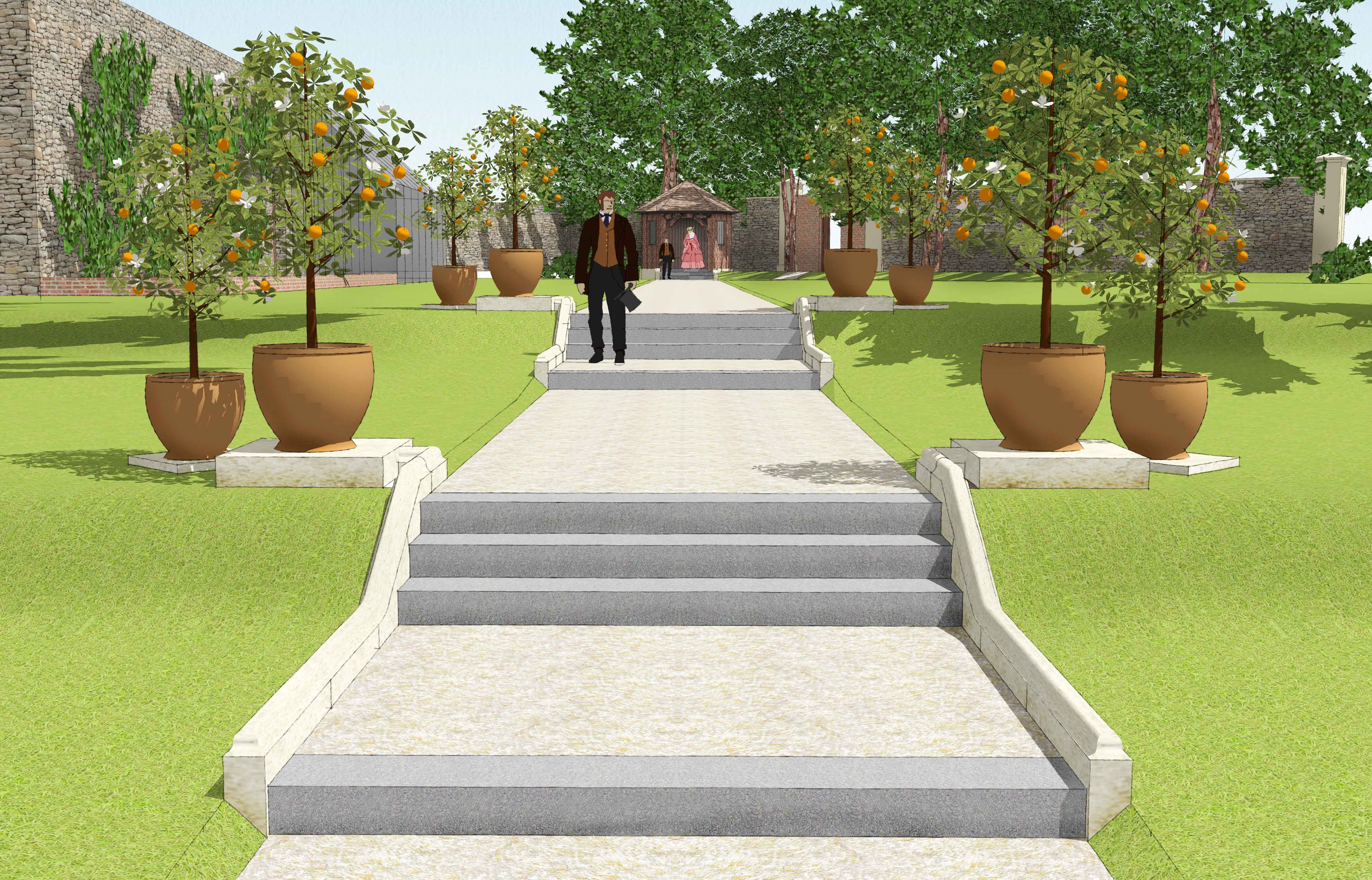
An impression of how the view along the axial path might once have appeared. The lower and upper steps are lined with potted citrus trees and in the distance the garden building presides over the whole scene.
Next month we’ll report on a few surface finds from the area, but if you can’t wait until then, you’ll find everything in the full report now available on our website If you’d like something more interactive, you can explore our 3D scans of the excavated areas:


