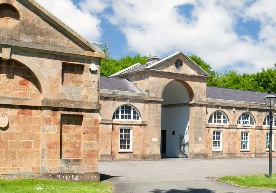
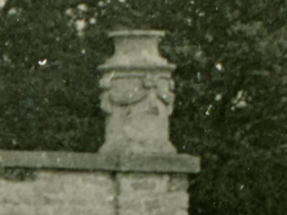
Across Napier Miles Road, the design of the Georgian stable block has led to a popular urban myth; this regards the keeping of giraffes by the owners of Kings Weston house, and the need of a particularly large arch in the centre of the building to accommodate this exotic species. This, to the very best of our knowledge, was not the case, but makes for a great yarn. On the other hand, there was a hippo…
The tall arch of the former stables, giving rise to rumours that giraffes were once housed there.
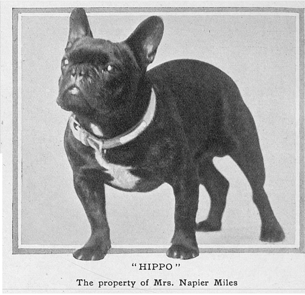
Like many visitors to the estate today, Sybil Napier Miles shared a love of dogs, and particularly pedigree French Bulldogs. She bred these in the early years of the 20th Century, adverts regularly appearing in the press for the sale of these pedigree pups at Kings Weston house. Her particular favourite, and award winning, dog was Hippo. The Tattler reported in 1916, that the two-year-old Hippo had been “quite a sensation” at the annual shows, a “wonderfully cloddy little dog”.
The real Hippo of Kings Weston house
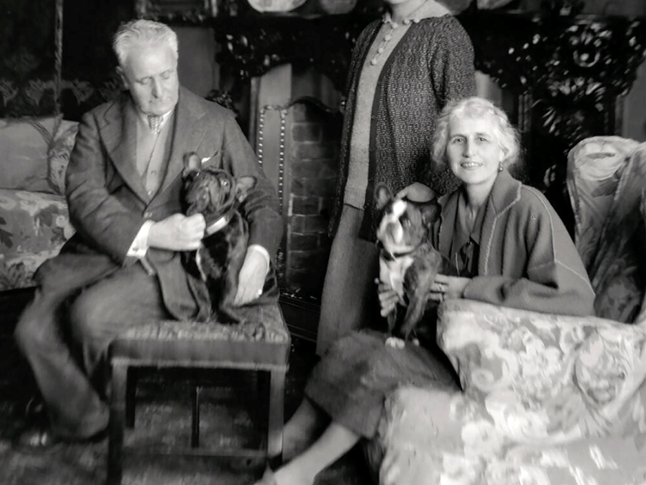
Hippo was clearly a much-loved pet, for he also managed to feature in portrait photos taken of Philip Napier Miles and Sybil a decade later, no doubt in his dotage. So, Hippo can now join the list of illustrious past residents of Kings Weston house.
Philip Napier Miles makes a fuss of Hippo, whilst another of the couple’s French Bulldogs poses on the lap of Sybil Napier Miles.
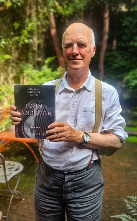
Charles Saumarez Smith with a copy of his new book.
Back in June 2024, we were delighted to have been able to share some of our research and time with Sir Charles Saumarez Smith, distinguished British cultural historian and curator known for his leadership of national institutions including the National Gallery and the Royal Academy. We spent an enjoyable time with him on his tour of Kings Weston house as part of his research into its architect Sir John Vanbrugh. Now, after a long wait, his new book on Sir John Vanbrugh to be launched in November!
We hope there will be some good coverage of Kings Weston and its buildings. Charles will be the first author to correctly document the dates and construction of the house in any book. We were pleased to be able to share our own research with him and support his own archival investigations.
The book, titled John Vanbrugh: The Drama of Architecture, will be launched on 20th November with a lunchtime talk to be held at Wigmore Hall, London. Copies of the book will be available at discounted prices after the event. If you would like to attend, full details are available here.
The cover of John Vanbrugh: The drama of architecture.
Also coinciding with the tercentenary of the death of Sir John Vanbrugh, Charles will be co-curating an exhibition on the famed architect at Sir John Soane’s Museum. Organised along with the V&A, the exhibition will open in February and feature many of Vanbrugh’s drawings, and, we hope, some Kings Weston exhibits.
These events are all part of a national celebration of the work of Sir John Vanbrugh. The Georgian Group have been fortunate to receive a six-figure grant from the National Lottery Heritage Fund to coordinate a series of events and commemorations across six of the architect’s most famous sites (though sadly not Kings Weston) throughout 2026. Dr Anya Lucas, Director of the Georgian Group, says “The tercentenary of Vanbrugh’s death represents an important opportunity to celebrate and bring to the fore the story of one of our period’s great architects, a bold and theatrical figure who is sure to have broad appeal and who should be better known.VANBRUGH300 will bring the life, stories, and work of Vanbrugh together for a wide range of audiences.”
We hope to share more of the commemorative events when they’re launched, and perhaps will be able to organise our own celebrations at Kings Weston.
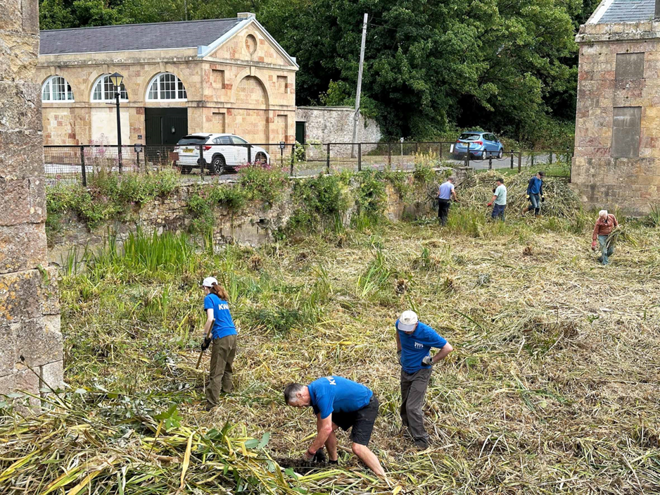
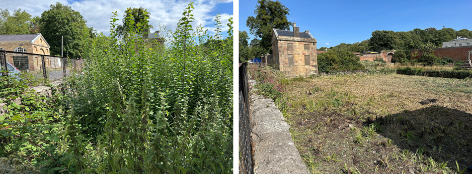
There were some herculean efforts put in last month from a crowd of volunteers, over a dozen, and we managed to make serious restoration progress on the historic lily pond on Napier Miles Road. There were two objectives the work; firstly, the cutting-down or rooting-up of trees and vegetation that has grown to suffocate the pond, and to enable a clearer survey of the condition of the pond walls and bottom.
Even after a long dry Summer, it was a surprise to find no open water at all in the pond tank! The vegetation has acted to soak up much more water than would be usual, and the ground was relatively firm across the whole area.
Volunteers rake-up the cut rubbish in an effort to clear the historic lily pond.
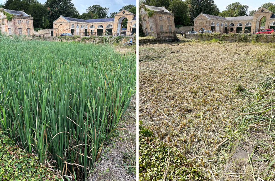
The target to cut and remove the vegetation was only just met by the end of the day, the hot conditions meaning volunteers tired quickly despite the great turnout. The waste was lifted to the pond edges and stacked in existing piles of debris up and away from the water line. Sadly, there was little sign of any of the 49 individual native pond species recorded here in 2012 as part of our Bioblitz. There were two types of reeds, sporadic water lily plants, some froglets, and an invasion of sallow trees, but nothing that indicates a thriving environment.
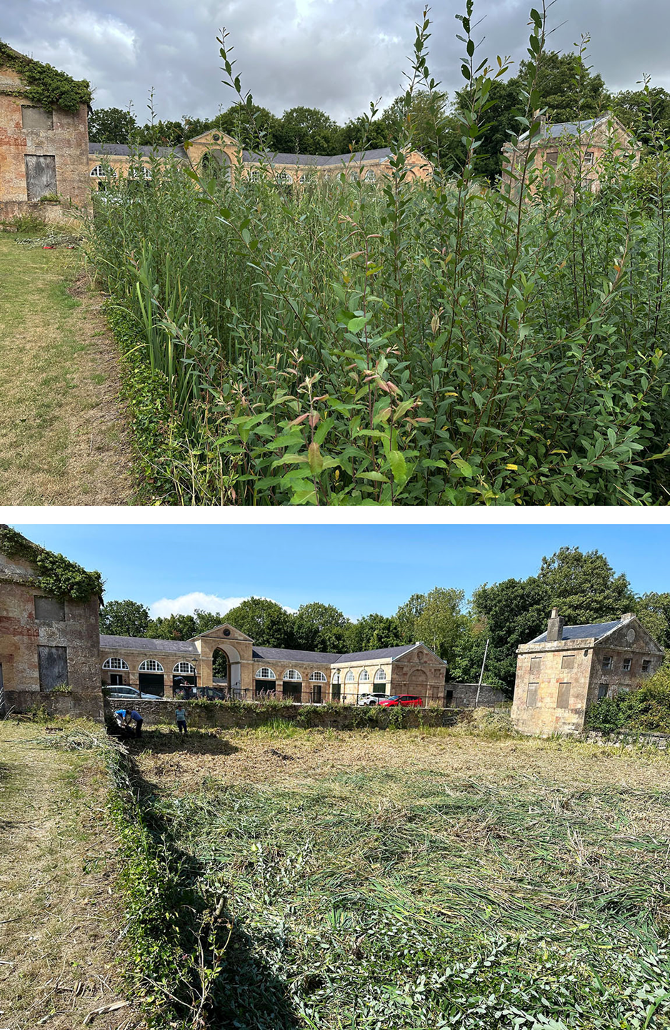
Before and after work focussed on reversing the decline of the Georgian pond.
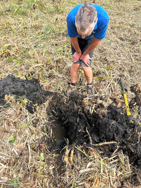
A volunteer inspects the trial hole dug through the decaying vegetation to find the pond base.
Initial review showed the original hydraulic lining applied to the pond walls has dried and begun disintegrating, allowing water to leak away around the edges. We dug a small trial hole to establish the depth and condition of the lining of the pond. Digging down through an astonishing 18 inches of black sloppy rotting organic material, we encountered the original clay bottom of the pond.
In the area inspected, this looked to be in a decent wet condition, but where areas dry out in the summer, any cracked clay base or root damage will also be letting the water leak away. The hole we dug filled with water during the afternoon, showing that even though it looks like a field right now, the water is still close to the surface.
A quick calculation suggests there are around 350 cubic metres of mud needing clearing out to start restoration of the pond lining. This could equate to about 340 tons of black gunk that need removing from the pond!
We’re grateful too for the incredible positive reaction to this work, and the kind words of support we’ve received; more than for any other project we’ve undertaken on the estate!
The view from the road before and after restoration workThe dense monoculture of reeds is cut out to slow the decline in the pond’s condition.
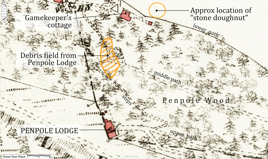
July’s working party location coincided with a large pile of rubblestone strewn down the hillside at the foot of the steps through Penpole Wood. It’s an area we’ve explored before, with the knowledge that the stones are some of the last remnants of Sir John Vanbrugh’s Penpole Lodge that once stood immediately above.
Victorian map of Penpole Wood annotated to show the debris field of rubble from Penpole Lodge.
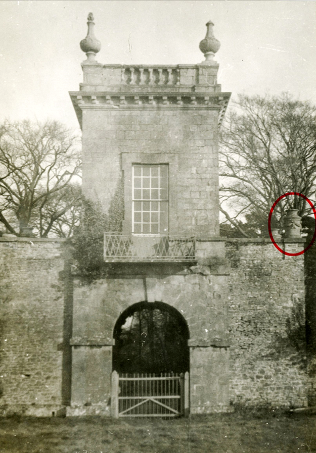
The landmark lodge, built around 1724, survived in good condition until the last private owner of the estate, Philip Napier Miles, died in 1936. It was kept in good condition too by Bristol Scouts who bought the woods as a campsite shortly after, but decay set in during WWII, accelerated through vandalism in the years following, and finally succumbed to demolition teams in 1951.
Penpole Lodge in the 1920s showing the cylindrical altar-like urns.
It’s not known whether all the rubble arrived at its present location hurled from the building by vandals or simply by labourers, but both were probably responsible. It looks as though the stones settled naturally in the location rather than being dumped deliberately, though the area is well defined and localised amongst the trees.
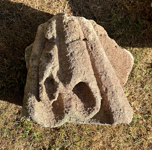
Having hunted through the pile for architectural artefacts before and been disappointed, it was a surprise that working party volunteers began discovering some interesting fragments as they worked. Other pieces have since been recovered.
So far, five individual stones have been salvaged, four of which have since been identified as having been parts of monumental urns from the flanks of the 18th Century building. There were two types of urns on the building, four on the central tower, and four squatter cylindrical ornaments lower down on the supporting piers; in their general form these were designed to evoke ancient roman temple altars. The fragments come from these
A clearer detail of one of the lower urns illustrating the gathered and draped swags
A photograph taken shortly before Penpole Lodge was demolished shows it in a derelict condition and from the angle taken three of the cylindrical urns had already been toppled and lost. The fragments now discovered are most likely to have been from the most northerly corner, out of view from the photographer here. The other urn on the western corner had vanished much earlier, and the location of fragments close to the surface suggest they arrived there at about the time the building was disintegrating by one means or another.
A fragment of hanging drapery carved with delicate folds.
It’s been possible to identify the source of these stones by carved details still preserved and recognisable through comparison with historic photos. Fragments are curved and carry carved swags replicating textiles that are seen decorating four sides of each cylindrical urn. One represents the gathered rosette or knot, another the end of the cloth hanging loose beneath it, whilst two are sections of the intermediate swags.
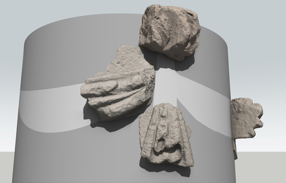
Having scanned the stones using photogrammetry, it’s been possible to arrange them to suggest how they might have fitted together. But, we’re far from certain whether the fragments were in this actual configuration, as none of them fit together. The two swags are from similar locations from two of the swags.
The four fragments scanned in 3D an arranged to give an impression of the location on the drum of the urn.
What is odd is that the urn has been so comprehensively destroyed, broken into such small pieces. Whether the drums were solid or hollow, a great deal of effort must have been expended in rendering them down to a collection of such similar sized pieces. Surely this was a deliberate reduction to rubble?
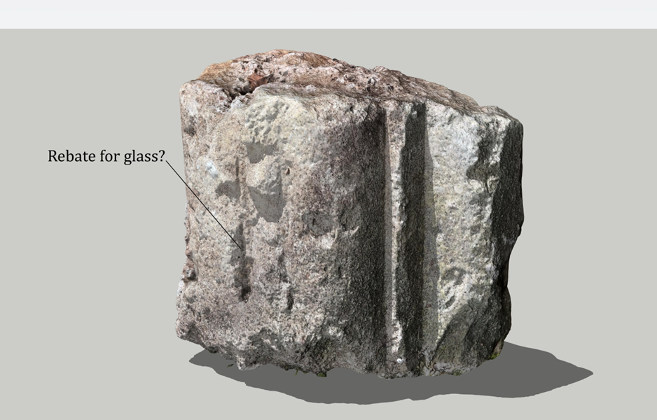
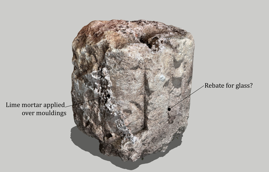
A fourth stone is more of a puzzle. It doesn’t correspond with any known detail of Penpole Lodge, either from photos or recorded in survey drawings made in 1947. One side of it has white mortar applied over its carved detailing, suggesting it was re-used from elsewhere. The carving is regular and linear, and has convex and corner mouldings on two of its outer edges. A rough slit runs up most of the ling edge, suggesting it was a rebate for glazing. The mouldings stop close to the bottom, suggesting it connected with something at its lower edge.
Two angles on the fourth fragment showing some of its key features.
It’s likely to have been part of a window surround. It’s location in the debris field suggests it came from the rubble fill of the walls of Penpole Lodge, but this can’t be proven. Neither can the original source of the stone be confirmed. However, there was an earlier ornamental belvedere on the same site, known from engravings, estate plans, and other illustrations. It was a hexagonal structure, perhaps a banqueting house, and would have been demolished to make way for Vanbrugh’s more ostentatious Baroque building. Perhaps this is a fragment of that earlier structure?
One final artefact is worthy of note – referred to as the stone doughnut. This is the last portion of one of the other urns, the larger structures from the very top of the lodge. These urns were formed with great bulbous centres surmounted by tapered pinnacles from which stone flames once emitted. At some point one of these urns fell from the lodge, shed its pinnacle, and rolled like a wheel much further than any of the other debris, finally coming to a rest at the very edge of the woods. There is survives today, too massive an heavy to move, but, hopefully, salvageable someday.
The “stone doughnut”, the major portion of one of the upper urns, now to be found at the foot of Penpole Wood.
The Council’s Nature Nurture events happen across parks in the north of the city every Friday. A number of these have focussed on nature conservation work around the Kings Weston estate and included several opportunities for scything.
A few regular KWAG volunteers came out for the two events last month focussing on the grassland on Penpole Point, joined by Council rangers and new volunteers.
Scything isn’t something KWAG has put on before, so it was interesting learning to use different tools and techniques to help maintain the important grasslands. Over two of the Friday sessions we got to grips with the area sown with wildflower meadow five years ago, raking-off the cut material to keep the grassland healthy. The area around the ruins of Penpole Lodge were also tended to, but the encroachment of brambles and elm runners remains an issue.
the area around the 17th Century dial before and after scything and raking.
The Nature Nurture team also hope to focus on the two ponds close to the Echo, brining a corporate group of volunteers to help clear in and around it, and set up a post and wire fence to keep dogs and debris from finding their way into the pools instead of the wildlife hoped for.
The Council are also looking at thinning some of the self-seeded trees from around the pond, trees that undermined KWAGs last effort to clear them by overshadowing them and filling them with dead leaves in Autumn. We hope everyone will appreciate the efforts now being put into increasing the biodiversity of this part of the historic parkland. If you have any concerns or queries, please email us and we can pass them on.
The current sorry state of the ponds below the Echo.
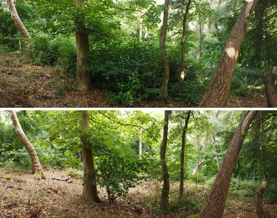
It was one of the hottest days of the year when we met in July for volunteer work in Penpole Woods. Not only was it hot, but the chosen location was distant from all of the usual meeting points. The area, deep in Penpole Wood, was at the bottom of the steps we rebuilt about ten years ago. Until last month they deposited the visitor into a thicket of cherry laurel.
Animated transition showing the view from the bottom of the Penpole Wood steps.
Already, someone had been trying to keep the paths there open, taking out branches overhanging the path, but our ambitions were somewhat greater. Considering the forecast, we had a good turnout, and thank you to all our regulars who made it. We started with the knowledge we’d cut things short to avoid the worst of the heat, but the shady area on the north-facing slope gave us some respite from the worst of it.
The impact of work turned out to be more incredible than expected. A relatively dense cherry laurel gave way quickly, revealing a number of handsome mature trees that hadn’t really been noticeable at the start of work; If we’d have spotted them earlier, we might have been a bit more careful over the location of spoil piles and their visibility.
Animated transition showing the view eastwards along the middle path.
By the end of the day, the section of the middle path we worked on was unrecognisable. Now, coming off the end of the steps, the scene opens out into a light clearing with a backdrop of fine trees. The route up from Lawrence Weston has been cleared of a lot of obstacles and joins the middle path at a junction at the stone steps. Hopefully the path remains traceable through the stone rubble.
We had planned to return here this month to continue work, but an urgent matter has cropped up at the Lilypond. September will be Heritage Open Day, and October is usually the Big Bulb Plant, so continuing the work may take longer than planned.
Looking west along the middle path before and after work clearing cherry laurelThe three stone steps between the middle path and main steps appear from beneath the cherry laurel.
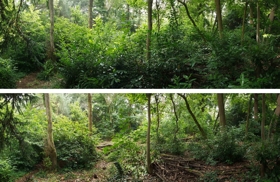
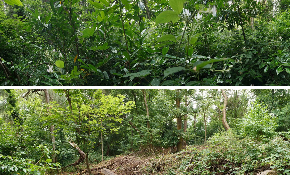
Worked carried on into July to clear the regrown cherry laurel in Penpole Wood. Most visitors will see little change from the recent work much is hidden well back from the main path through the woods. However, the impact of cherry laurel on the native woodland is severe if it’s let get out hand.
looking west through the wood before and after the re-trimming of the cherry laurel.
Since we cleared the area in 2016 there has been a lot of regrowth, particularly on the harder to reach area along the top of the former quarry. Because the laurel has historically stunted tree growth in the area an opening had developed in the tree canopy and Brambles had begun to colonise the area aided by the catenary of laurel stems; in short, the area was in a big mess again.
the view east through the working party area.
A relatively small group of volunteers, a usual state of affairs for the holiday season, set about putting things in order and extending the areas cleared in the last few months. Cherry laurel has been felled again, untangled from the brambles and stacked out of the way. More of the saplings planted in 2016 have also been revealed again in thriving condition. Whilst there remain some laurel bushes to the periphery of the area, ones we had neither time nor energy to tackle on a hot day, there’s not enough to occupy a full working party. These will be left for the moment while we focus on new areas.
looking up slope from the edge of the old quarry and towards the main Penpole Wood path.
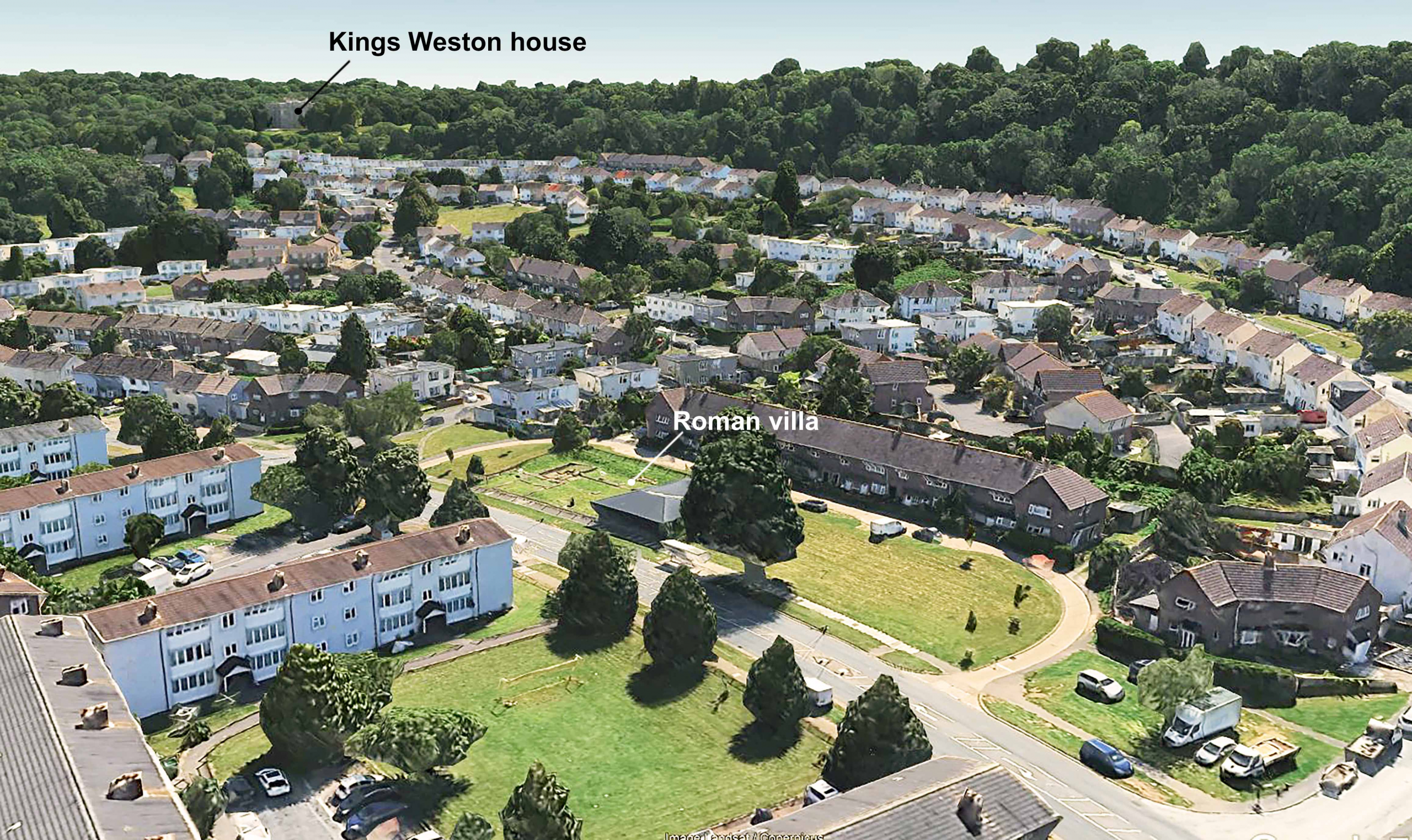
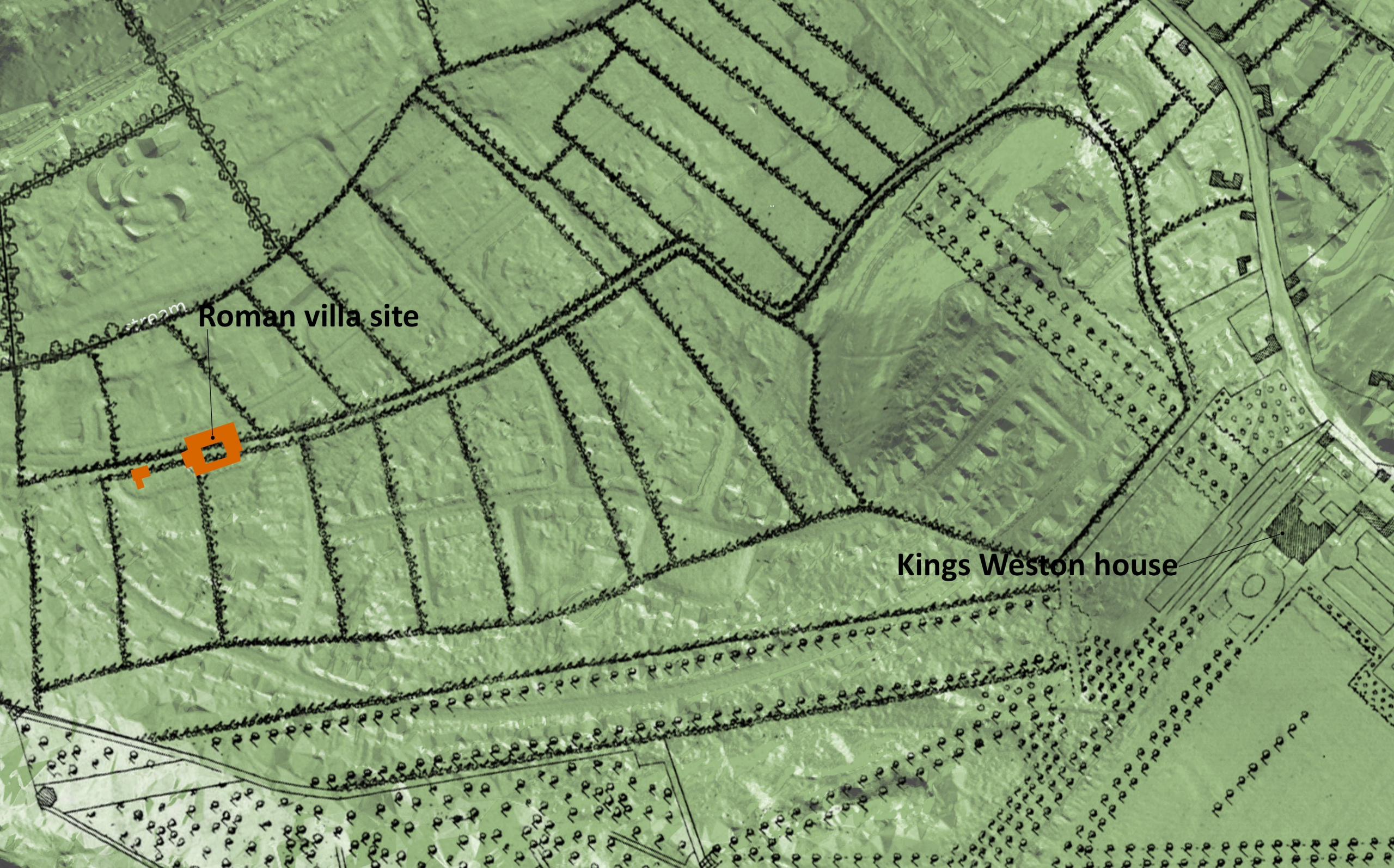
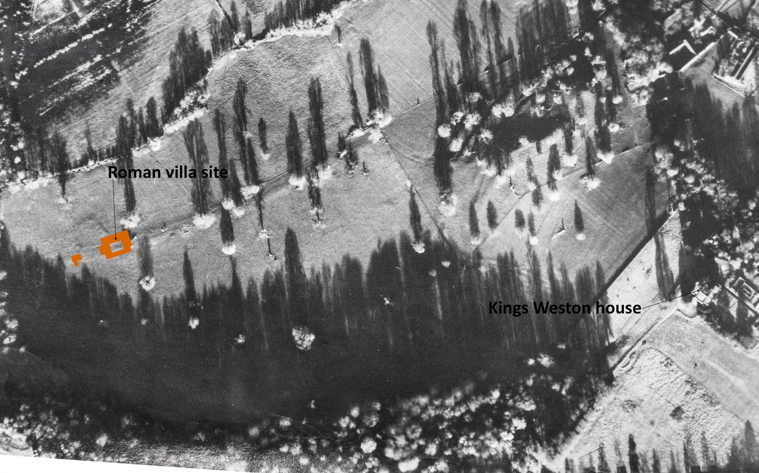
There’s been some exciting developments at the Kings Weston Roman Villa. The ancient ruins lay undisturbed beneath the grounds of Kings Weston house, unknown to its owners for more than 1,500 years, until Lawrence Weston estate was laid out over the northern part of the landscape parkland in the late 1940s. The remains were badly damaged before their significance was realised in 1947. Several seasons of archaeological work between 1948 and 1950 revealed the extent of the main villa building including decorative mosaic pavements and a bath complex. The remains were consolidated and the site made a branch museum of the city’s Museum and Art Gallery. Whilst there’s been regular new work on understanding and interpreting the site and its finds since the 1950s, there’s been little archaeological work done on the site…. Until now!
Aerial view showing the Roman Villa in relation to Kings Weston house.
Some of our Bristol members might have seen an awful accident in October last year reported in the press, when a car came off the road and crashed into the site. Fortunately, the vehicle made little impact on the roman remains themselves, hitting the surrounding fence and timber museum building only. The need to put this damage right, a small grant, and the desire to make the site more accessible has enabled the museum and archaeologists to commission new survey work.
Much modern archaeology depends on non-invasive techniques rather than the traditional digging of trenches. Ground Penetrating Radar is now regularly used to explore below ground; we’ve even had areas around Kings Weston house surveyed before now. It was this type of survey that was recently undertaken by Wessex Archaeology on the open grass areas immediately surrounding the museum’s boundary fence and the results have been remarkable. The full report can be read here.
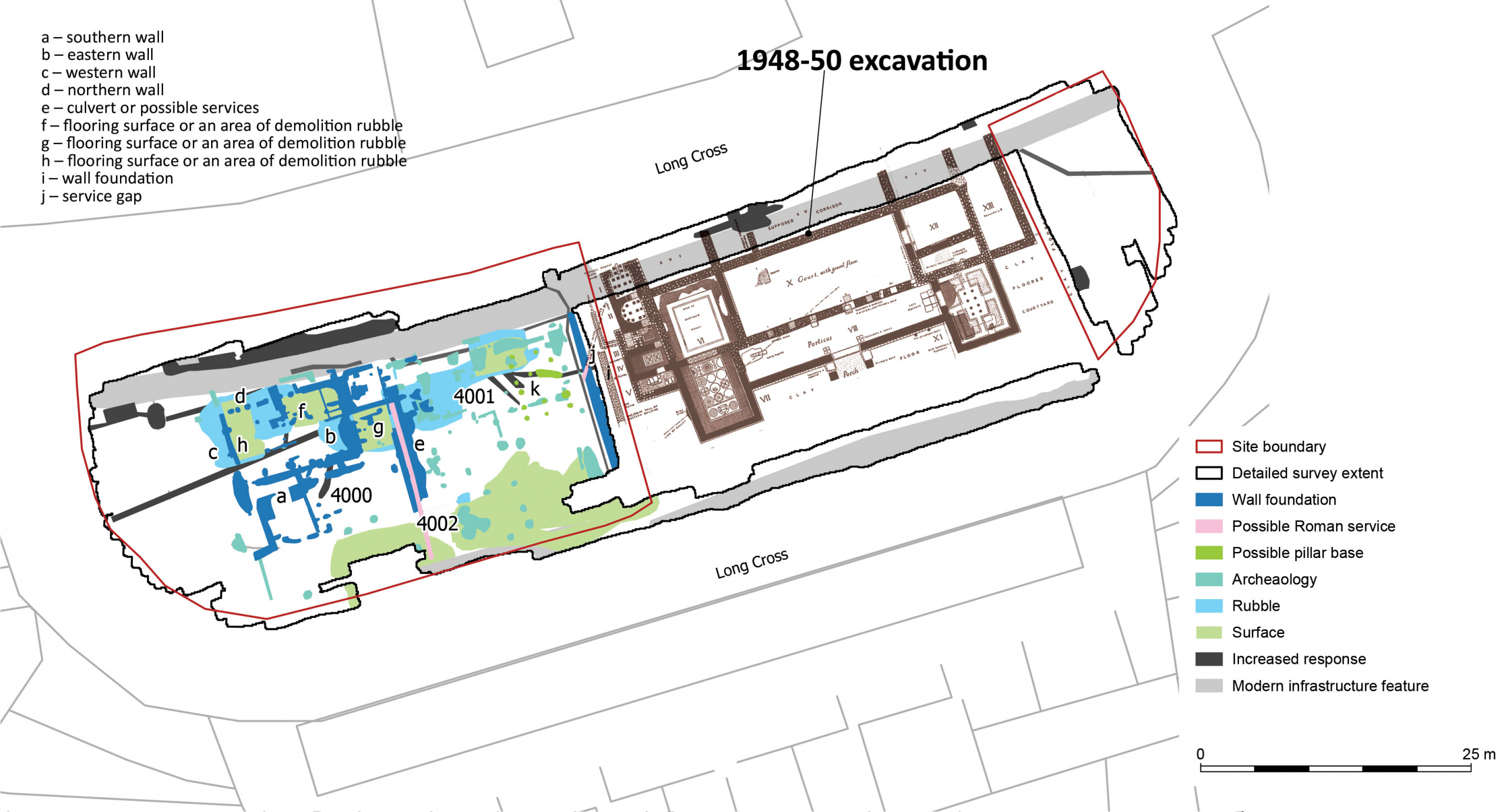
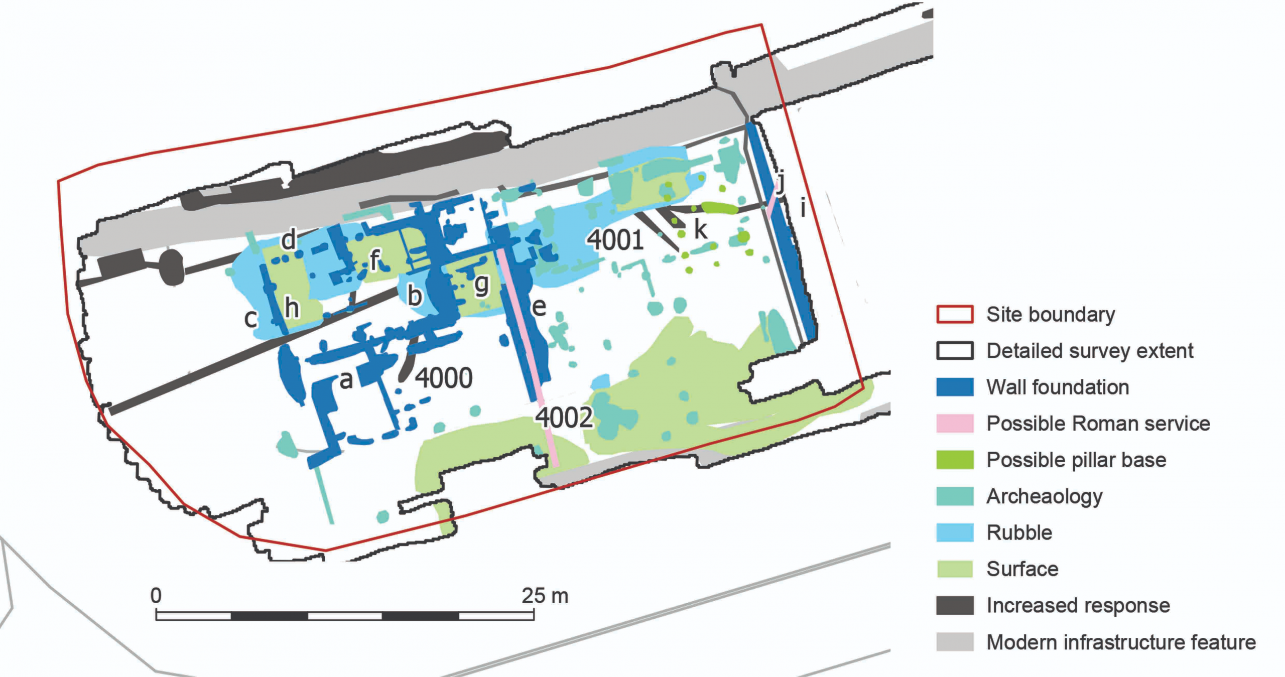
The new GPR survey in relation to the villa excavated 1948-50
Despite a lot of interference due to modern features like the pavements, the geophys results have identified more buildings to the west of the villa, and of formed surfaces that might be interpreted as trackways, yard surfaces, and internal floors. The remains are at a similar level to the existing Roman structures, so can be confidently dated to about the same era. A few features deserve further focus here.
Detail of the GPR summary diagram showing all the features identified.
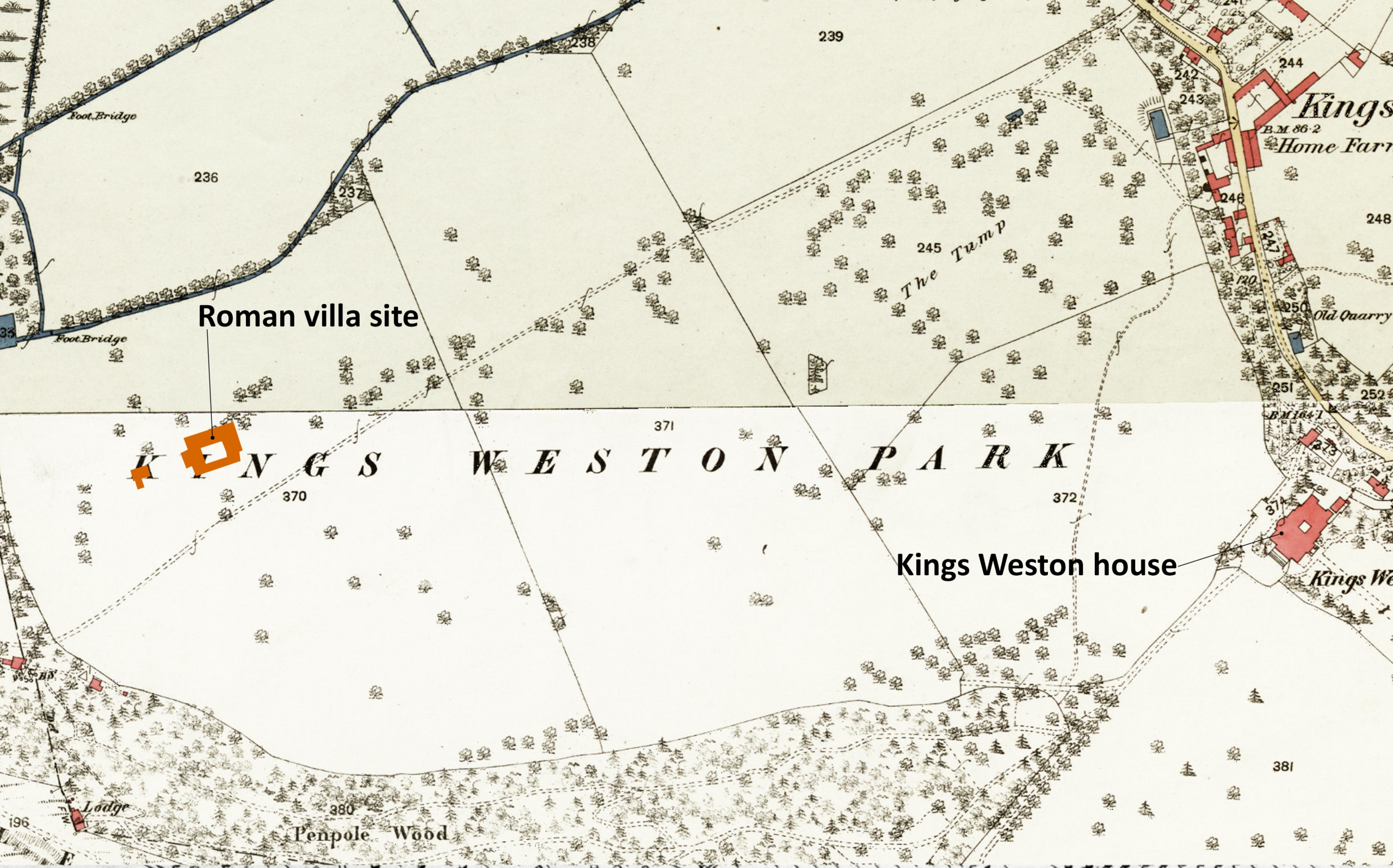
The south edge of the site, pale green on the plan, suggests a made surface running east-west across the site and possibly continuous with the clay floor identified in the post-war excavations. The location of the villa in the landscape, and this surface might represent an historic track passing across the front of the villa and perhaps a yard in the newly surveyed area. Projected eastwards, any road may have connected with several other Roman sites identified in Lawrence Weston. It’s a remote possibility that the Roman track alignment perpetuated into the modern era as a farm track known to have been in existence by 1720, and surviving in some form until 1947.
Below: The location of the Roman villa shown on maps of 1720, 1772, and 1946 and its relationship with an historic track passing through the historic parkland.
The location of the Roman villa shown on maps of 1720, 1772, and 1946 and its relationship with an historic track passing through the historic parkland.
The wall foundations, dark blue on the plan, clearly follow the same geometry as the villa itself, a strong indication that they were related and probably existed together. A north-south wall on the east side of the site seems to have matched another in the excavated area, leaving a gap of no more than 2m between them. It’s an odd arrangement; could it have been a narrow passage or lane? A water pipe appears to pass diagonally through both areas, probably feeding the bath house, but from where did the water come?
Another, similar, arrangement of parallel foundation walls occurs halfway across the new survey area with a narrower channel between the two that has been interpreted as a channel or culvert, perhaps another water system. Whether these walls extended above the historic ground level isn’t clear, but a demolition rubble layer was only found associated with the north end of the feature and possibly associated with buildings there that may stand over the channel feature.
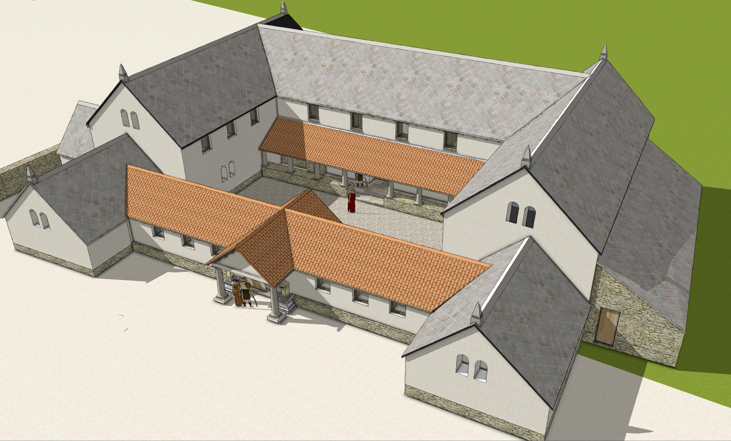
Our reconstruction of the Roman Villa viewed from the south east.
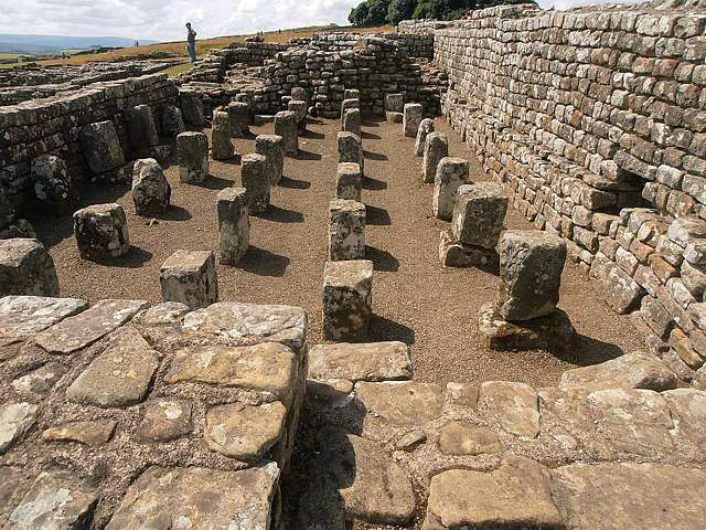
Probably the most exciting discover has been a building or complex of buildings gathered around the north-west corner of the site, structures previously unknown. The main structure is judged to be about 12m east-west and 8m north south, by no means large, but perhaps with attached structures and internal subdividing walls. Three areas of made floor surface have been identified at f,g, & h on the plan.
A granary at Housesteads Roman Fort with supporting pillars holding timber floors
Pale blue areas are suggested as loose rubble and debris, perhaps from collapsed buildings, and mainly distributed along the north side of the new area and suggested buildings. The dark green features are peculiar, indicating stacked masonry features like pillar bases or pilae that supported heated hypocaust floors. Without any enclosing walls, it’s possible that they supported a building raised off the ground, like a granary.
The purpose of the buildings will remain a mystery until any physical archaeological intervention takes place, but the villa would have been at the heart of an agricultural estate. It’s barns and other farm buildings have not previously been located, so it’s possible the area to the west provided these functions. The potential identification of a granary supported on piers might support that suggestion; this is, however, all hypothetical at this point.
The museum service hoped to explore this new area more in the future in old-fashioned archaeological dig where they hope to get community involvement. We’ll report more when details are released. But for now, why not take advantage of some forthcoming open days to quiz curators and archaeologists on the new discoveries? The villa will be open later this month as part of the national Festival of Archaeology for three days between 23 July—25 July. Full details can be found here as well as other dates this year when the villa will be open to the public
Anyone with an interest in archaeology will probably have heard of LiDAR before. It’s a technology that uses laser pulses to measure distances and can be used to create complex 3D models and map large areas of land. It has the ability to penetrate trees and vegetation and help reveal what lies beneath. It’s been used in archaeology for a number of years now and has helped discover features as large as cities in Egypt and temples hidden in the Amazonian rainforest.
Lidar mapping of the UK has been publicly accessible for a while, even appearing as a layer of Bristol’s Know Your Place website. We’ve made use of it before, but recently a more detailed and informative new survey has become available through the National Library of Scotland website. This new map has helped reveal some of the hidden features of the estate with new clarity.
The Lidar map for the whole of the Kings Weston estate, trees and buildings removed to reveal the topography below. The Avon is obvious at the bottom of the image, Penpole the bright finger of land on the left, and Kingsweston Hill identifiable by the sharp outline of paired quarries.
Unfortunately, Penpole Wood and the steep slope down to Lawrence Weston has proved too confusing for useful interrogation, but the lawns around the house, largely flat and open and undeveloped for centuries, prove perfect for enhancing the data to better through features into relief. When compared to documentary sources, what we’ve discovered from this exercise is interesting but throws up new questions over the development of the grounds.
At first glance the plan looks a psychedelic confusion of stripes and rectangles. The location of Kings Weston house has been added to the plans to help orientation. The ancient avenue it a distinctive line running south-west, diagonally from the house to the bottom left-hand corner where it meets The Circle. The South Walk runs through the jumbled ridge along the bottom of the image, and the formal gardens and path to the Echo complete the basic triangle back to the house. Different colours show slopes of land exposed to five different directions, explaining the red, orange, yellow, turquoise, and blue colour scheme.
The area around the house and lawns enhanced to throw details into relief. Kings Weston house is in black at the top of the image.
The lines and stripes can eventually be read, some crossing over the top of others, and some cutting through different layers. Using what we know from maps and other illustrations we can interpret these lines and place them in order of when they were created.
The lowest of these layers, Phase 1, the features which pre-date the historic park, are a series of wide strips running south-west to north-east, roughly the same alignment as the ancient lime avenue, but much earlier. We’ve previously postulated that some of the more significant ridges, visible with the naked eye even, could be the alignment of a roman Road passing through the estate, but the new LiDAR map shows a distinct curve at their south end, definitely not something the Roman engineers would have approved of! Instead this is likely a field boundary or track passing between two fields. South of this, the grain of ridges becomes tighter and less pronounced. The ridges can be traced passing through later features, albeit more faintly, or stop abruptly, showing attempts were made at erasing them later in time. In other areas, such as the south-west corner, they seem to survive ghostly beneath stronger features laid above them.
PHASE I – strip fields and ridge-and-furrow marks are interspersed with field boundaries and, perhaps, a trackway.
These lines represent long field divisions and the tighter-grained likely to ridge-and-furrow agricultural management of the landscape. The City Archaeologist has suggested that these are early-medieval in character, so perhaps established around the Norman Conquest. At this date then, we see that the plateau was principally farmland, though it’s unclear whether a manor house existed, or whether it was even on the same site as the present house. Of course, the ridges do not preclude an earlier, Roman, landscape having existed below them.
The next phase has only become visible using this new edition of the mapping. It also includes lines, but these are of an irregular fan-like pattern bounded by a shallow banked perimeter. This looks to overlay the old field pattern below it, and is interpreted here as the levelling-out of the park, with material being dumped in lines, each line built up from west to east, gradually building up the land before being levelled-out. These features are hardly noticeable when standing there today. That the lines spread out along the ancient lime avenue suggest that it existed as the main access for the work.
PHASE IIA – A levelled area pushes out from the line of the present ancient lime avenue and over earlier agricultural features.
Dating this phase is difficult. There is nothing that documents its formation, but its relationship with the avenue and the apparent intention to landscape the terrain suggest it relates to aesthetic improvements, so possibly the 16th or 17th Century when the agricultural landscape had become the park to the late-Tudor mansion.
The levelled area was certainly in place before a series of trees were planted in a straight line mirroring the orientation of the ancient lime avenue. These trees can be seen as a series of shallow circular depressions dug through the fan of ridges. From the c.1710 engraving of the house we know that there was an avenue on this alignment, one that stretched as far as the Tudor house. The survival of the avenue depressions on the levelled area, but not closer to the house, might be explained by the softer nature of the made ground.
PHASE IIB – Regular lines of trees and formal garden boundaries redefine the landscape as a parkland focussed on the late-Tudor mansion.
Of this same phase, a long straight bank through the park and more apparent tree pits seem associated with each other; both are noticeably deliberate and linear. They relate to a second line of trees shown in the engraving, and are another designed garden feature. Garden works at this period also involved the north-eastern side where the earlier agricultural formations are sliced through, or heavily overlaid by new rectilinear boundaries aligned with the formal gardens laid out on this side of the house. A formal grove or orchard shown in 1710 seems to have extended closer to the house than shown in this illustration of a plan from a decade later; this was an anomaly noticed a few years ago when dry weather caused parch marks to form.
Features in this engraving by Johannes Kip of around 1710 correspond with those identified on the LiDAR plan.
Great changes were wrought across the estate between 1713 and 1728 when Edward Southwell employed the architect Sir John Vanbrugh to redesign his house and parkland. A plan, the Hallett plan, was drawn-up in 1720 and shows many features from the next phase of development. The provision of a grand new frontage facing the old avenues resulted in a new formal court being required to receive guests. Although the carriage drive continued to follow the ancient lime avenue on its northern alignment, substantial works were enacted to excavate and level the new court and create a perfectly flat axial lawn leading up to it. A low causeway was thrown-up to bridge a natural depression in the landscape in the cause of perfection. The embankment and spoil from these works overlaid the medieval field pattern.
PHASE III – Sir John Vanbrugh’s fondness for grand gestures is embodied by the efforts required to excavate a level Great Court and build a perfectly flat causeway leading to its gates.
Two other features register faintly from this phase: the vestiges of the Great Terrace and a linear garden feature known only from the 1720 plan. These are both to the north of the ancient avenue and have been heavily impacted by the de-formalisation of the parkland and landscaping that occurred later in the Georgian era. Of these works little can be detected from Lidar, perhaps on account of the intention to naturalise the landscape in the picturesque manner.
Hallett’s 1720 estate plan at the same scale and orientation as the LiDAR plan helps pinpoint this phase’s features on the landscape.
A gap exists in the story LiDAR provides, between the early 18th Century and the 20th. Deformalizing removed formal features rather than creating new ones, and had a generally lighter impact. No great changes were made during the 19th Century, nor early Twentieth. The next obvious mark is a curious dumbbell-shaped feature that, from aerial photos, was constructed in 1947. What this feature was is something of a mystery, but if anyone knows what it was used for, we’d be keen to know! A couple of other features sit outside of the known phases, one amorphous lump lying over the medieval landscape, and a small circular depression further eastward. These, perhaps, will remain a mystery.
PHASE IV and unplaced phases. The dumbbell shaped feature close to The Circle was built immediately after WWII. Does anyone remember what it was?
For a number of years, the dreaded Ash Dieback has been slow to take hold at Kings Weston. While other areas in the city were quickly decimated by this fungal disease the estate has been less quick in succumbing. We identified early signs it had arrived several years ago, and perhaps it’s the prevailing winds off the Severn have blown spores away and slowed it’s progress. However, it’s now very much caught up with us.
A series of ash trees and large boughs have fallen recently, these across one of the main paths through the woods between The Circle and Mancroft Avenue below. KWAG volunteers have now cleared all but the trunks from here. .
Even trees on The Circle have become bare and begun dying. These grew up since the 1960s.
Whilst Ash was not commonly planted in the Kings Weston parkland in the Eighteenth and Nineteenth Century, it has become established, particularly since WWII and the institutional decline of the historic estate. There are of course some notable exceptions, huge mature trees that have established in Penpole Wood and elsewhere. Most, though, are of middling size and have thrived on neglect.
These more mature trees are now the victims of die-back, with many now showing advanced signs of ill health. Penpole Wood has recently been littered with fallen ash, or large boughs that have broken away from distressed trees. You’ll notice the ground around ash trees littered with leaves and dead twigs, and their canopies thinning and full of dead twigs and dying branches.
There are a series of dead or dying trees alongside the historic Viewing Terrace behind the Echo, a number on the Circle, and many more overhanging paths and public rights of around the estate. There is a genuine risk to the public from these dying trees, so we urge everyone to be aware, particularly during windy weather. We hope to go through the parkland soon with the parks team to discuss the problem and identify which trees may need to be dealt with and brought down before they fall.
Ash trees at the top of the slope above Shirehampton Road, immediately over the Georgian Viewing Terrace and the public right of way are now heavily impacted, with some already dead.


