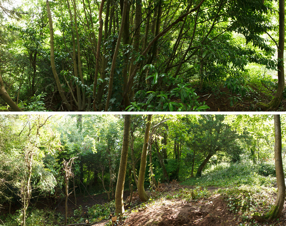
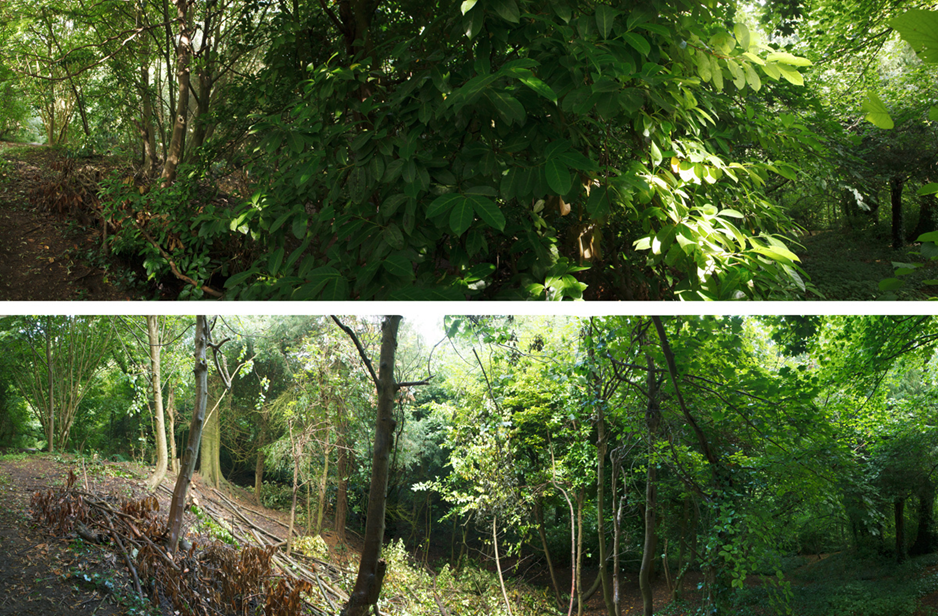
Perhaps it was the forecast of bad weather, or the holidays, but we had a very low turn out in July for the working party. However regrettable, we were still able to make headway on our challenge of clearing cherry laurel from an area close to the historic Scouts chapel in Penpole Wood. We will need to return here again this coming week, to today as much as to complete the job.
The difference made between June and July, with the lime trees of the Scout’s Chapel appearing beyond.
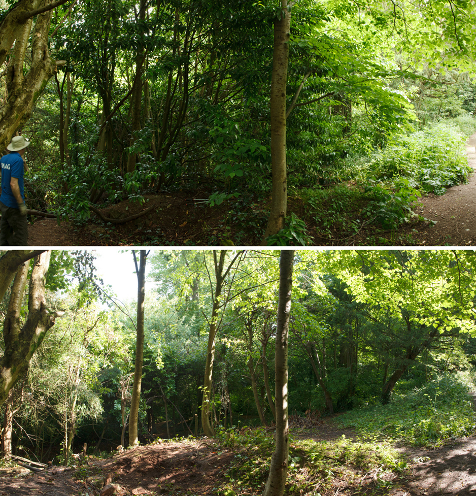
The work over the last couple of months has revealed another post quarry, later turned into part of the landscaped grounds of the house. As well as views through the woods to the tall lime trees around the Scout’s chapel, itself part of the Georgian landscaping, work has opened around a mature beech tree and yews. The last push in August should add another beech tree to this collection of veteran parkland trees and open the woodland floor for colonisation by native species.
Because of the small turnout, and the rain that eventually curtailed efforts in the afternoon, we were unable to property and safely tidy up the area, but we made sure that nothing was blocking any public areas around the quarry. Apologies for the unsightly mess, but we’ll make sure to clean it up this time around!
looking eastwards, along the slope, with the main path through the woods on the right.The view in the opposite direction, in the direction of Penpole Point.
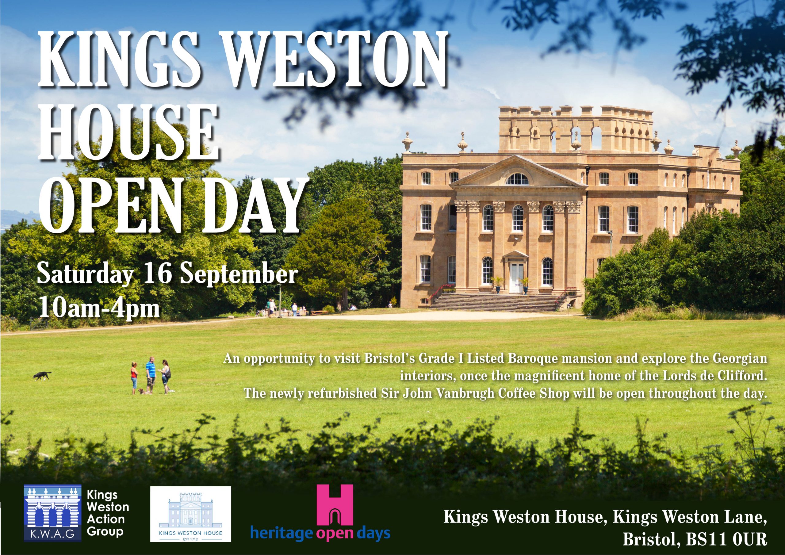
Heritage Open Days is nearly upon us! This year Kings Weston house will be opening on Saturday 16th September for FREE! There will be guided tours around the state rooms, our exhibition panels, and plenty to see on the day. Everyone is invited to come along between 10am and 4pm! Full details HERE.
This year’s participation in the national scheme again replaces the traditional Bristol event, which, sadly, appears not to be taking place this, it’s 30th, year. If you have anywhere to mount a poster please print off a copy of this PDF, or let us know where you would like one.
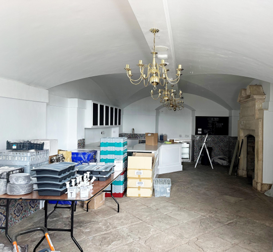
Fantastic news as the café at Kings Weston house is set to reopen next week, with a new identity inspired by the architect of the house: The Sir John Vanbrugh Coffee House. The café closed in its previous guise, Morgan’s Coffee House, in February, and work’s been underway since then to refurbish the venue. Whilst a coffee concession has been on-site intermittently over this period, its irregular openings have proved difficult to publicise. The reopening restores an important resource to the parkland.
work on the coffee house progresses a couple of weeks ago.
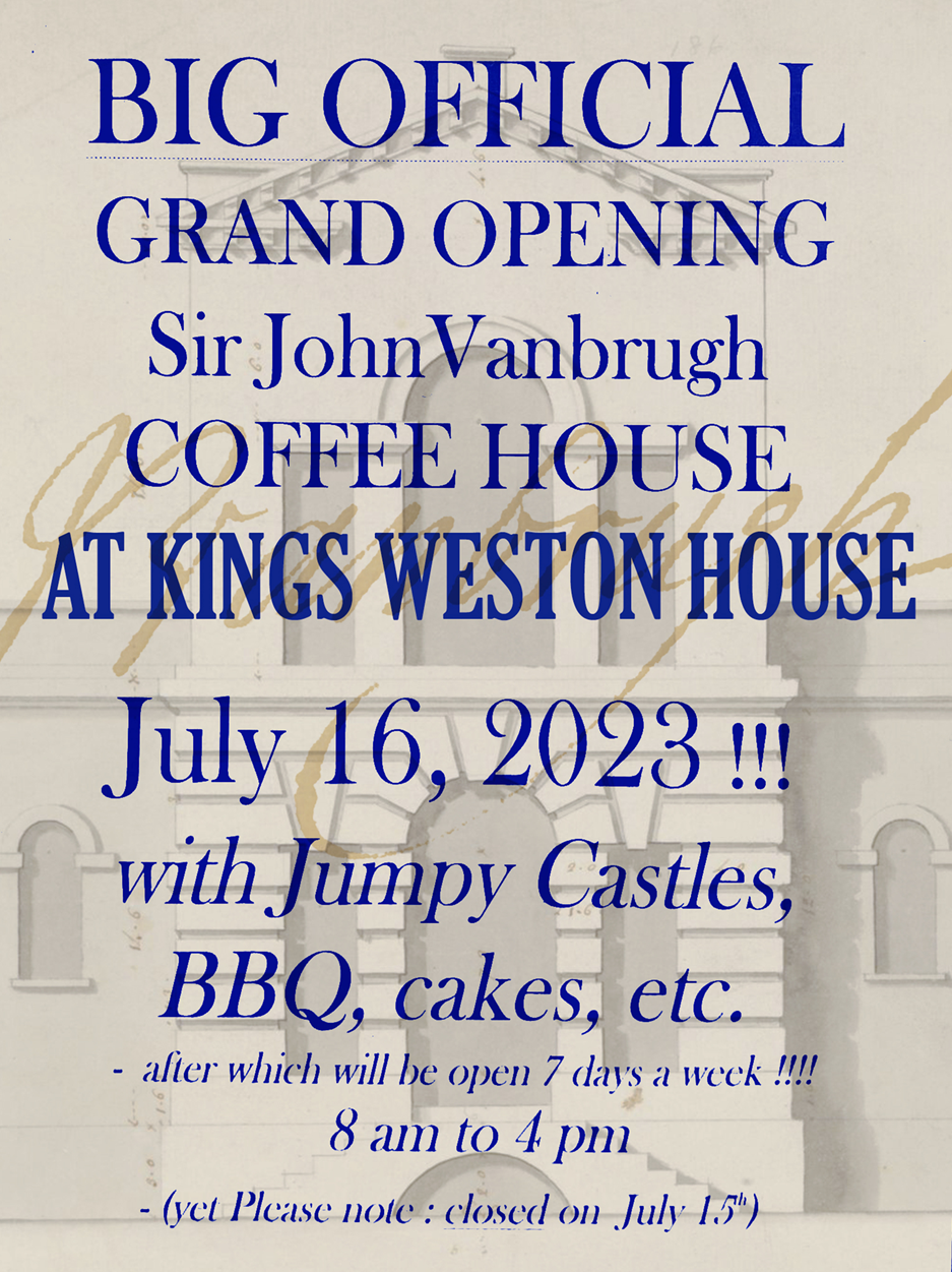
We’re delighted to announce that the coffee shop will have a soft opening on the 14th July initially, before a Grand Opening on Sunday 16th July (please note it will not be open on the intervening Saturday 15th). The grand opening is being advertised with a BBQ, cake, and bouncy castles. We wish the new venture good luck, and look forward to seeing it return as the focus for so many visits to the estate.
Coffee House opening times are advertised as 8am-4pm 7-days a week
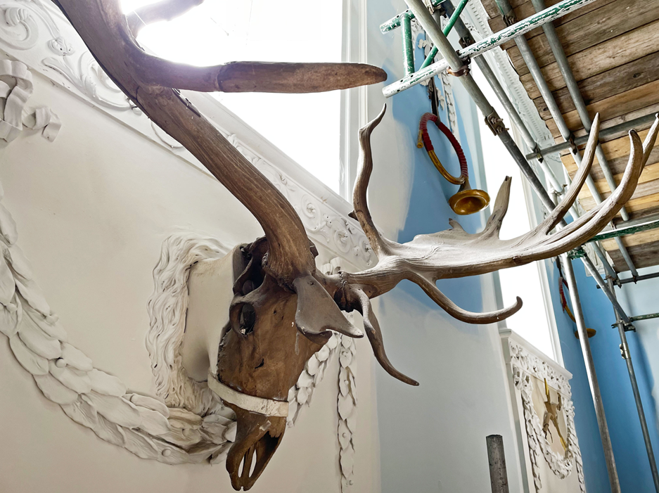
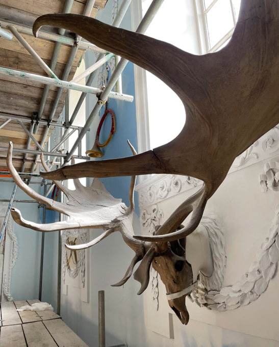
A feature older than the house itself hangs in the Saloon, or portrait gallery of Kings Weston house; it is in fact around 13,000 years old! This incredibly ancient artefact is the fossilised skull and horns of the extinct Great Elk. Today the antlers are integrated into the architectural treatment of the Georgian interior, as they have been since the hall was redesigned in 1769 by the architect Robert Mylne, but they’ve been at Kings Weston longer than that.
The skull and antlers of the Great Elk, or Irish Elk, incorporated into the Georgian interior design of the Saloon with stucco hunting trophies set around it.
A complete Great Elk skeleton (Wikimedia Commons)
The Southwell family who built the house were from a dignified Irish family in southern Ireland, but their wealth suddenly increased when, in 1703, Edward Southwell married Lady Elizabeth Cromwell. She was a wealthy heiress to a fortune, with an income of £2000 a year – around half a million in today’s money. Most of her family’s wealth came from extensive estates around Downpatrick in northern Ireland; these lands would remain the main source of income for the Southwell family for the duration of their time at Kings Weston. After Elizabeth’s early death in 1708, all her wealth passed on to her husband, Edward, known by family and friends as Neddy.
Neddy was a very learned gentleman. Like his father, he was a member of the Royal Society, the world’s oldest scientific academy. It was, no doubt, his reputation and interest in the sciences that led Mr James Kelly, probably the estate steward for the Downpatrick estate, to write to him in 1725:
“Since I know you to be a gentleman very curious in searching after nature I thought it would not be unacceptable to give you an account of those appearances that we meet with in searching for marle, now in so plentiful a manner found on your estate in this country.
Among the marle, and often at the bottom of it, we find very great elk horns, which we, for want of another name, call elk horns: where they joyn the head they are thick and round; and at that joyning there grows out a branch of about a foot long , that seems to have hung just over the beast’s eyes: it grows round above this for about a foot and some odds, then spreads broad, which it does in branches, long and round, turning with a small bend. The labourers are commonly so busie that they rarely bring them up whole; yet I have one pretty well, of which I send you an icon done as well as I could, but not so nice as I could with. We also have found shanks and other bones of these beasts in the same place.”
Another view of the skull showing the great scale of the antlers.
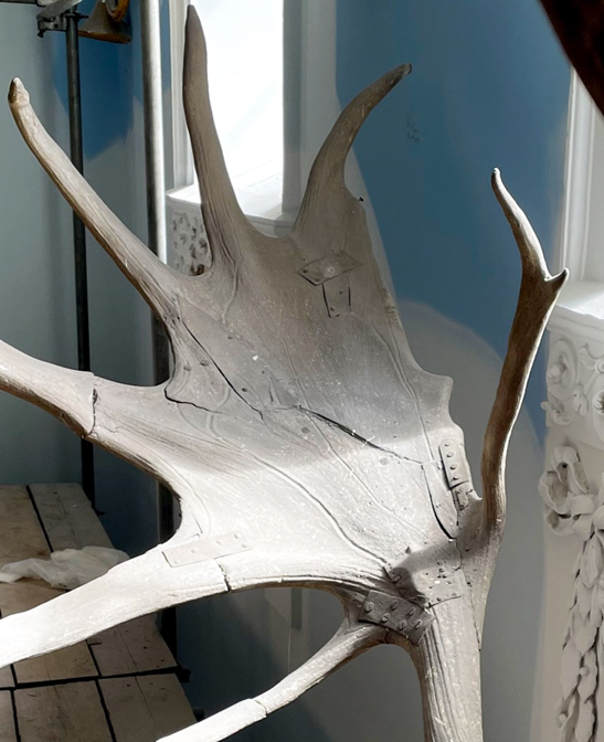
Detail showing the riveted repairs and mismatched parts added to complete the specimen
This wasn’t the first account of Giant Elk being discovered in Ireland, the first such being in 1695 when physician Thomas Molyneux made the first scientific descriptions from antlers discovered near Dublin, but the letter was of such interest that I was presented to the Royal Society and published in their transactions in December the same year.
We can’t be certain that the elk skull at Kings Weston is the same that Mr Kelly salvaged from the marl workings, but there’s a strong likelihood that it was sent back to Neddy for his closer study. If it wasn’t the same one, then it would have been another example excavated with greater care, for preservation. A close inspection of the skull where is hangs today reveals it wasn’t brought up whole, with a variety of metal plates of various dates holding it together on the wall. Some of these are likely to be from its original reassembly, with other pieces appearing to have come from other specimens, to make up a complete skull for display.
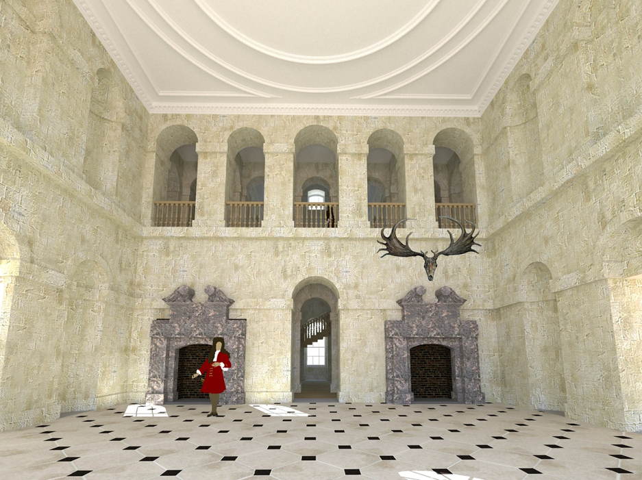
Whenever it arrived at Kings Weston it was immediately a trophy of great interest and was hung prominently in the saloon; this would have been the hall in its original form, as designed by Sir John Vanbrugh, and with stone walls, arcades, and architectural details. At the time there were a pair of fireplaces, one either side of the present later Georgian one. This explains the description of the room immediately before it was refurbished to its present appearance in 1769:
“From the landing place I passed to Kings Weston, the feat of Edward Southwell, Esq; built by Sir John Vanburgh. It is in his heavy stile; the hall the only tolerable room, and that rendered totally useless, by a vast echo. Before one of the chimneys, is a prodigious pair of elk’s horns, dug out of a bog in Ireland” (Arthur Young: A six week tour thru the southern counties of England and Wales)
A reconstruction of the Saloon, later the portrait gallery, in it’s original form, with an impression of how the elk might have been hung before 1769
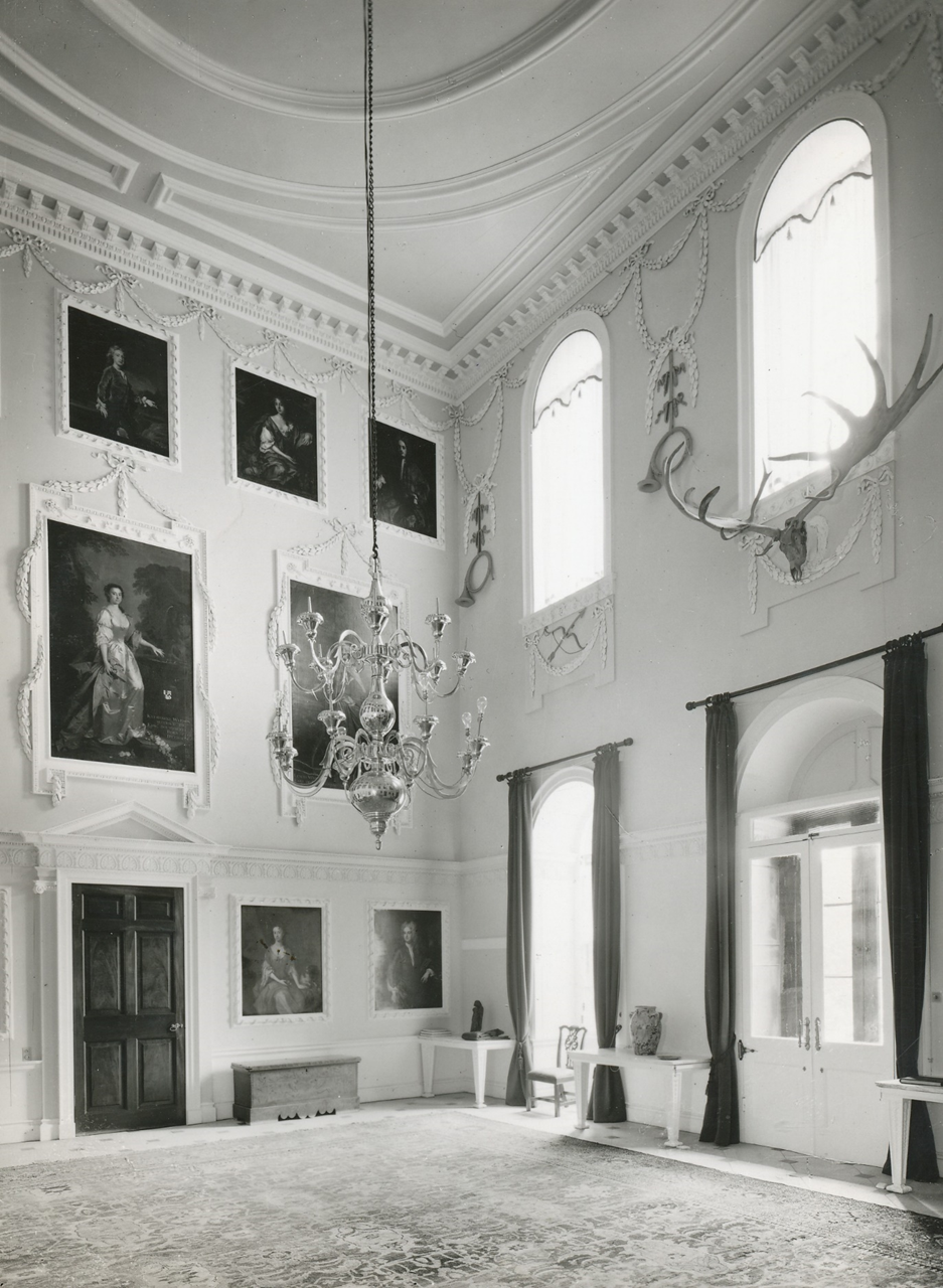
It must have presented quite a lopsided appearance for thirty-so years, a huge set of antlers above just one of the fireplaces in the hall, but this was rectified when the architect Robert Mylne was trusted with the redesign of the room as a grand portrait gallery for the family. He incorporated the skull and antlers into his designs, locating them immediately above the entrance door. To it were added a series of other stucco motifs, four horns hung from plaster swags and bows and arrows amid festoons, all moulded by notable plasterer Thomas Stocking. Rather than stand exhibited as an ancient artefact, the skull became read as part of an ensemble of hunting trophies.
Interior of the portrait gallery in 1927, showing the skull and antlers integrated into the overall interior design, with hunting horns and longbows adding to the hunting theme.
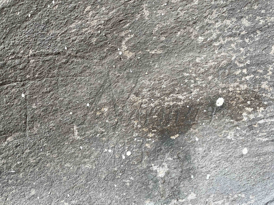
Restoration work in 2021 filled the Saloon with scaffolding, allowing closer inspection of the Great Elk fossil. The metal plates holding it together were clear to see; less clear was a scratched signature and date carved into the upper surface of one of the antlers. The date, we think 1834, coincides with the second great family of Kings Weston, The Miles’s, moving in. Perhaps a decorator hired for the refreshing of the interiors took the opportunity to make a bid for immortality by making their mark. Sadly for them the name is virtually illegible. If you can decipher it, we’d love to know!
Sgraffito name and date. The year looks to be 1834, but who was the carver?
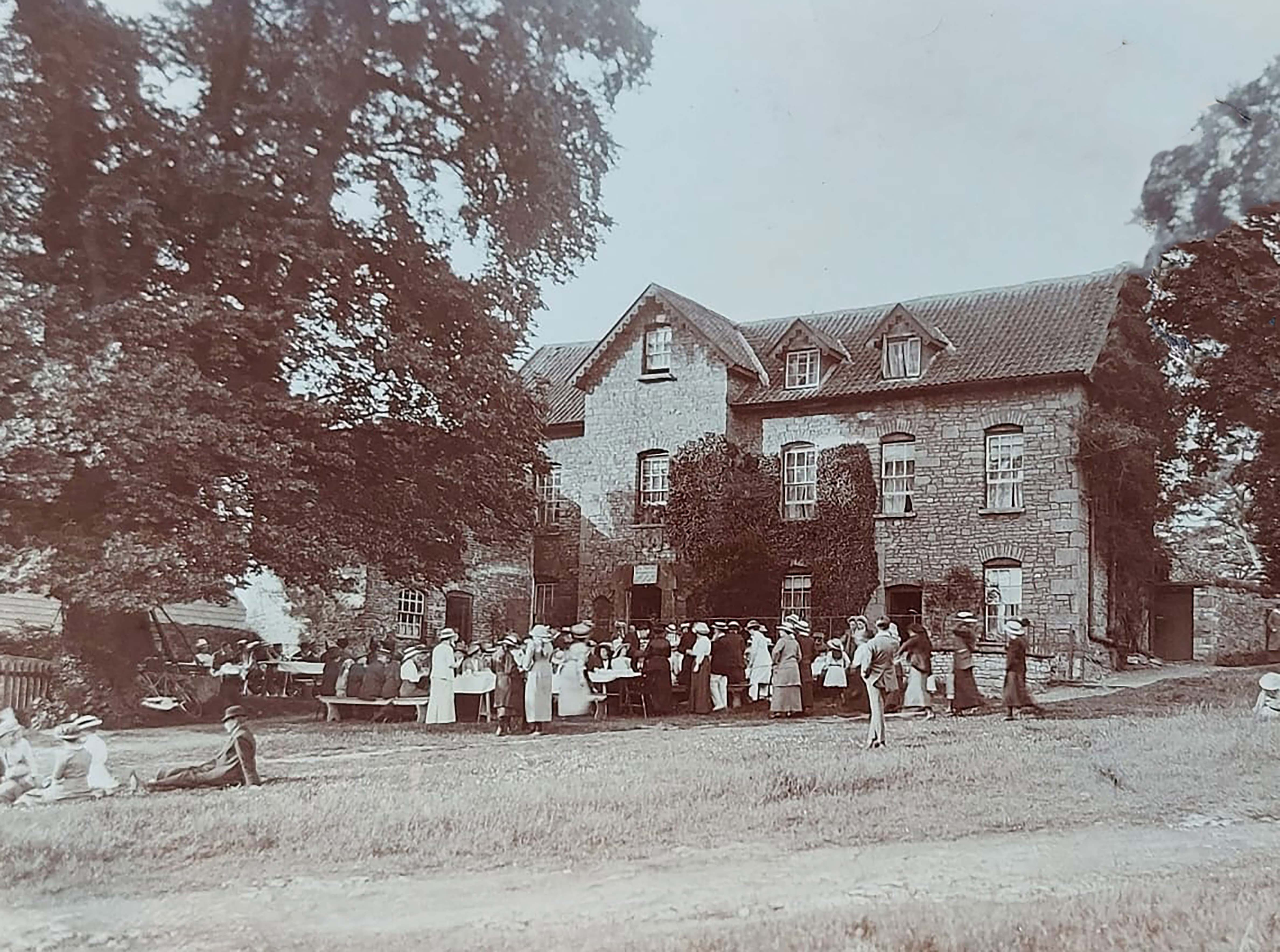
The acquisition of a detailed view of the former Kings Weston Inn is occasion enough to add a little colourful history to the building. The view shows the inn at the turn of the 20th Century with a large party of guests sitting down on long tables for refreshments. The inn had ceased trading as a pub by this point but is known to have offered accommodation for tea parties under a Mrs Withers. This may be one of the many meetings of ladies of the Primrose League, a Conservative organisation, that are known to have taken place at Kings Weston at this time.
Kings Weston Inn in the early 1900s with a large gathering over trestle tables
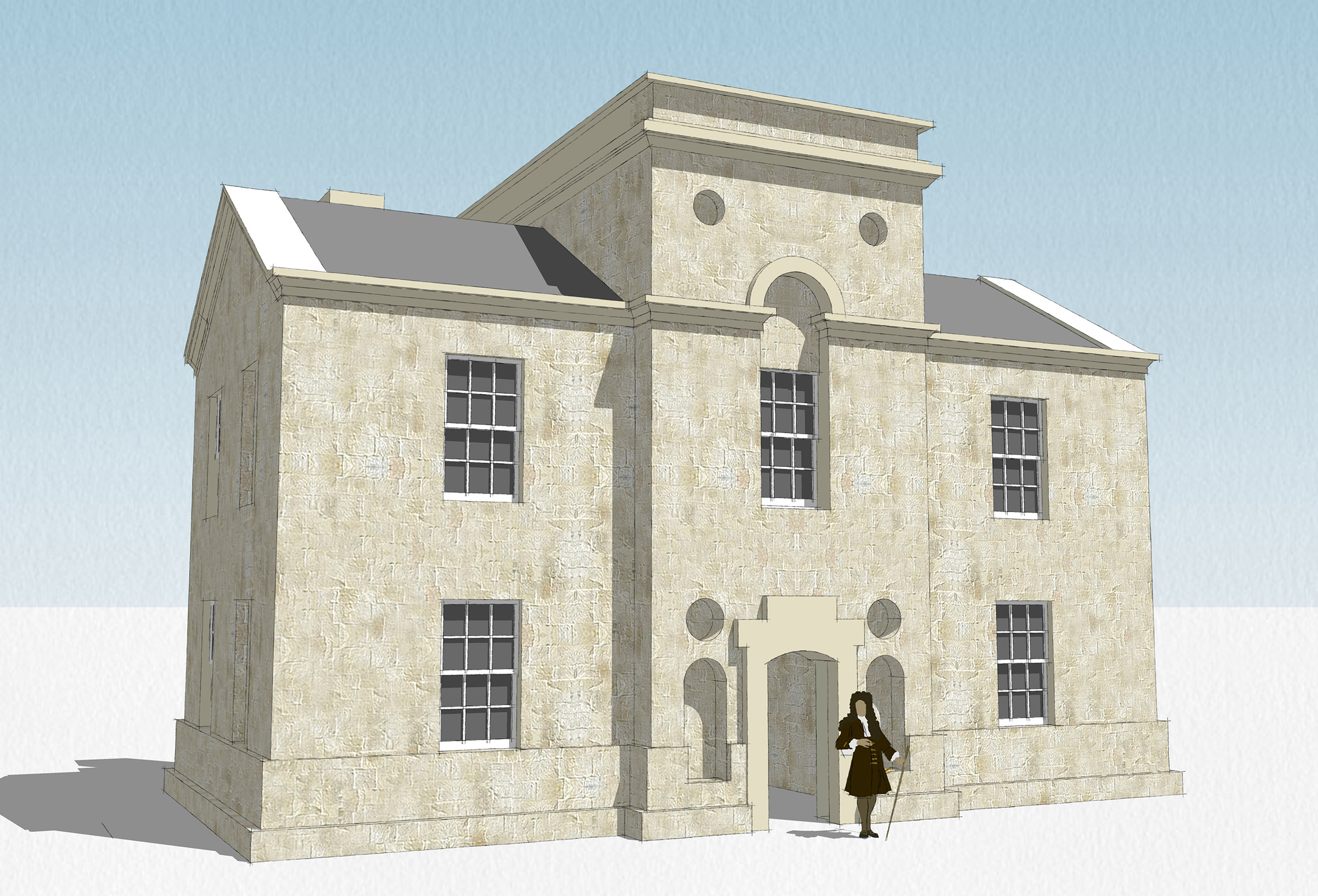
The building itself was probably built shortly after 1718, when a drawing for an inn, then ale house, at Kings Weston was drawn up by the architect Sir John Vanbrugh. The dated drawing was superseded by a later version that is strongly similar to the core of the present building, but we can also attribute this design to the great architect. The building was much smaller than it is today but with features that are still recognisable. A central dog-leg stair ran up the centre of the building with a simple room either side on each floor. The central bay of the building rose above the pitched roof, terminating in a low tower that, we believe, was used as a viewing platform for patrons.
The second plan for Kings Weston ale house, from the Kings Weston Book of Drawings. circa 1718. (Bristol Archives)
The building of inns to serve visitors was not unusual in the Georgian era, but that at Kings Weston is very early, being only a year later than the New Inn at Stowe, Buckinghamshire, built for the same purpose. Using the drawn dimensions has enabled us to create a simple 3D model of the building before later extensions and alterations changed its appearance. The architect’s measurements compare well with that of the core of the existing building.
We know that there were modifications in the mid-Victorian period, but even before then the building must have been found wanting. Parties from Bristol and Bath regularly visited the inn for recreation during the Eighteenth Century and it was part of well-published local tours.
Reconstruction of the original Kings Weston Ale House, before alterations.
In stark contrast to the genteel party in the new image, one intriguing report involving the inn comes to us from a newspaper report from 1774, perhaps one that may, or may not, be fitting for publication in Pride month. The incident followed a private tour of Kings Weston house for a couple of visiting gentlemen, given by one of the male servants there. The report implies that the servant was sexually assaulted at the inn by one of the visitors as the other sought to stop him from escaping. It’s not known who Mr L and Mr B were, they both escaped, though we the scandal broke Mr B fled the country all together, no doubt with his reputation shot, and fearing reprisals. How much truth there is in this report is unclear, but it shows the taboo of homosexuality at the time and the risks that men would sometimes go to:
Reading Mercury & Oxford Gazette Sept 12 1774
Extract of a letter from a Gentleman of Bristol to his friend on London Aug 31
An affair has lately happened here, which has been the general topic of conversation ever since last Wednesday, Mr B—-, Mercer of this city, and Mr L—–, a linen draper, not a hundred miles from the Haymarket, London, went in a chaise together to Kings Weston, to view the house of Edward Southwell Esq – At their departure they offered the servant who showed it a piece of money, which he refusing, they insisted on his drinking a glass with them at the inn they put up at. After they had drank pretty freely, Mr B—- on some pretence left the room; which he had no sooner done. That Mr L—- behaved in such an indecent manner as contrived the man of his brutal intentions; he therefore attempted to quit the room, but was prevented by Mr B—-, who held the door on the other side; finding he could not get out, and being irritated by such an infamous insult, fell upon him and beat him unmercifully.
The noise being heard below, brought several people up, which Mr B finding, thought proper to leave the door and fly to the window from whence he made his escape, leaving Mr L— behind to bear the insults of hostlers, cooks, chambermaids etc who kicked, cuffed, and clawed him, tore his hair, had the dogs set on him, afterwards uncovered him, rolled him in the nettles; finally the maids would have proceeded to castration, had they not been prevented.
Mr Southwell, being acquainted with the affair, ordered two men to guard him that night, with the intent of bringing him to justice the next morning, but he found means to bribe his watch, and got clear off before morning. As for Mr B—- he attended his shop as usual two or three days, till the matter became public, and everybody looking on him equally guilty, he thought fit to decamp, and has not since been seen; it is said that he is gone to France or Italy with an intent never to return.
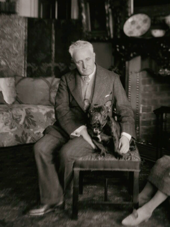
Four years ago we wrote a piece on the Garden City aspirations of the last private owner of Kings Weston estate, Philip Napier Miles. Now further evidence has come to light that show his enthusiasm for innovations in town planning and promoting the development of his lands for socially progressive housing
Philip Napier Miles and his French Bulldog, Hippo in the library at Kings Weston in 1926
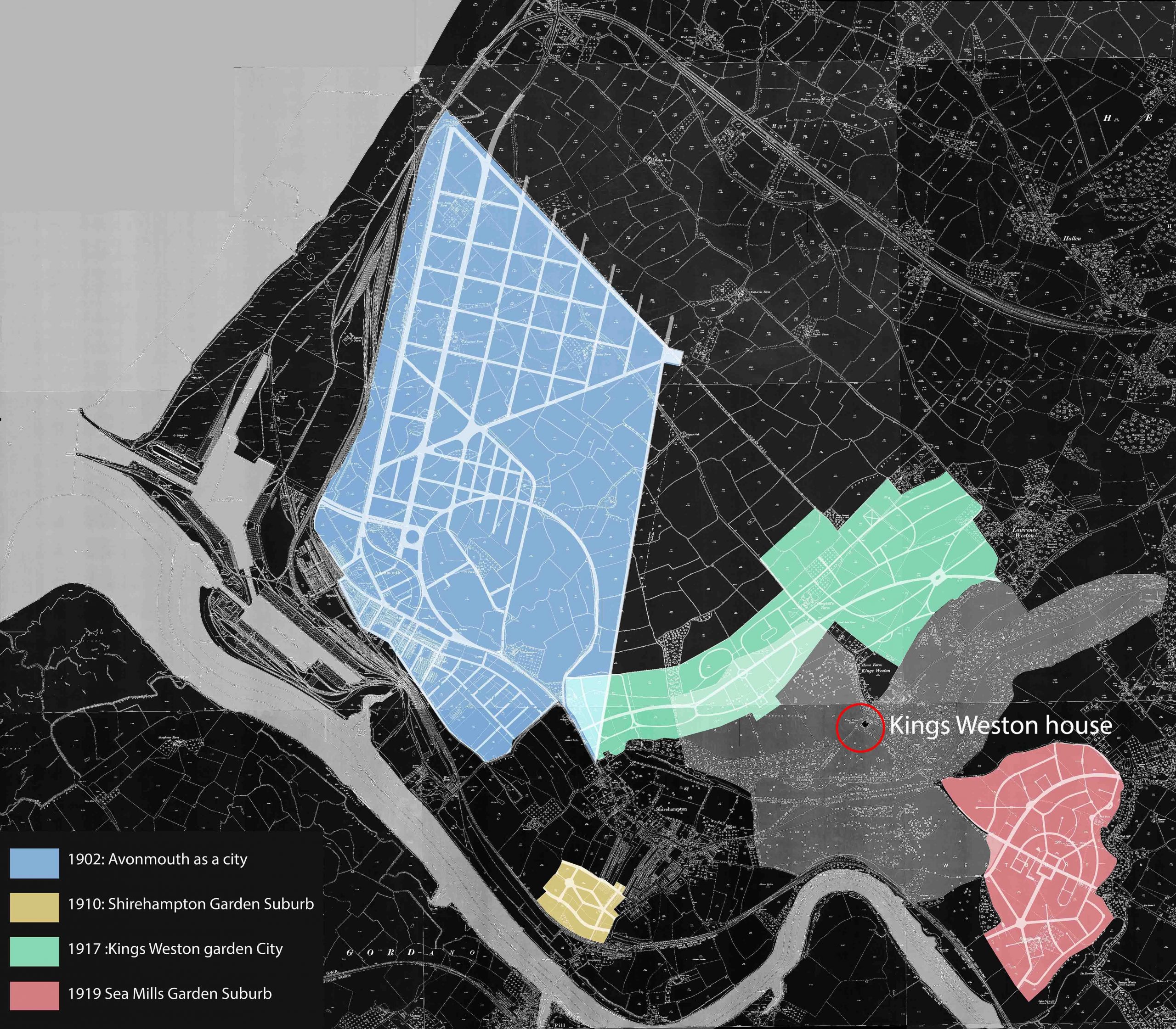
From the moment he inherited the estate from his father in 1881 Napier Miles seems to have been keenly focussed on making the best provision for his tenants and building new homes and facilities for their benefit. Beginning with new streets in Avonmouth he set out some of the best workers housing in the city, before becoming an early adopter of the revolutionary principles of the Garden City movement for new building. The movement promoted the idea that bringing together the best features of the town and countryside would provide the working class with an alternative to farm working or crowded unhealthy cities. All industry, housing, commerce could be provided interspersed with generous greenspace and allotments, and with key facilities to support education and social development.
Miles’s initial project to create a new city around Avonmouth began around 1902 but faltered despite having achieved a lot of high quality new building there. A smaller endeavour was endowed with land at a beneficial rate in Shirehampton in 1910: the Bristol Garden Suburb. Another ambitious plan for development was promoted by Miles in 1917 for the land immediately below Kings Weston house where the Lawrence Weston estate lies today. The main emphasis of the plan was to provide urgently needed housing for labourers at the recently built national Smelting Company zinc works in Avonmouth, and serve the urgent wartime demands. A Public Utility Society was created in partnership with the management of the zinc works, Ernest Bevin of the Dock Worker’s Union, Napier Miles, and other local dignitaries and business owners formed a committee.
A diagram showing the scale and distribution of Napier Miles’s Garden City projects
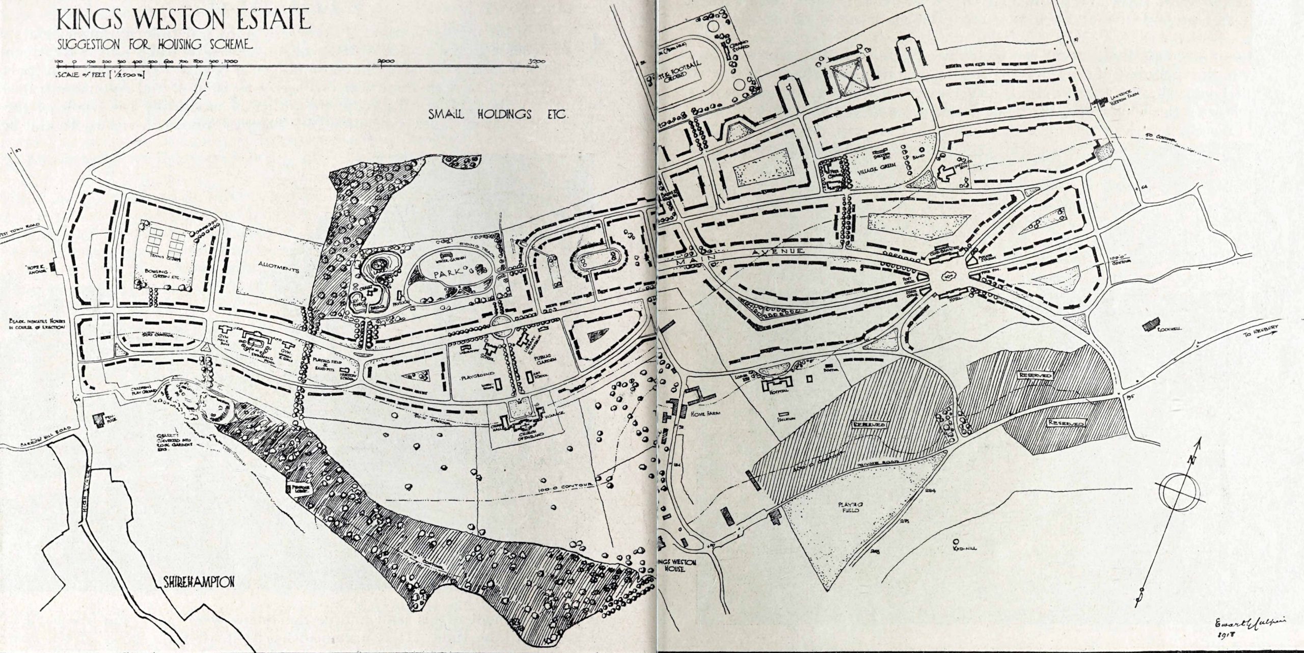
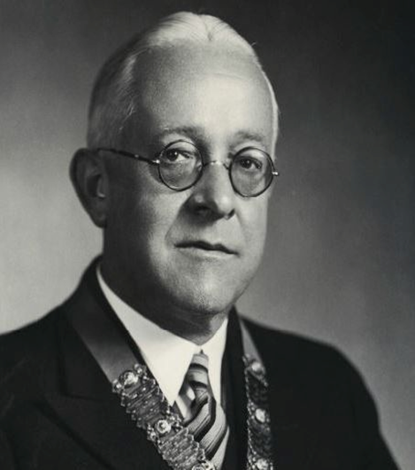
On the 15th May the committee met to discuss plans. Napier Miles provided a venue for a meeting between interested parties, under one of the giant beech trees in the garden of Kings Weston house. Ewart Culpin of the Garden City & Town Planning Association, a figure of national importance, provided a sketch layout of a 271 acre estate which, it was projected, could accommodate around 2000 homes for up to 150 thousand people. The plan was set out on Garden City principles with emphasis on green spaces totalling around 60 acres, and tree-line avenues, along a central spine road that approximated todays Long Cross. Progressive public and social facilities such as communal kitchens, wash houses, & laundries were designed in, along with land for a Trades Hall, schools and a hospital. On the western part of the estate were planned the social and educational centre, the church, schools, and other public buildings. A theatre, concert hall, Swimming pools gymnasium & allotments were also projected. It was described as having “more of the elements of a real garden city than in any other proposal since Letchworth”
The 1918 published sketch of the plan for Kings Weston Garden City, unfortunately with the house hidden in the fold between pages. The houses that were completed are on the far west side.
Co-operation was an imbedded feature of the organisation. Tenants were to become shareholders in the scheme with a vested interest in the estate. Napier Miles “in alluding to his sympathy with this movement, said he had strongly opposed the erection of buildings of such a nature and would in a few years become slums” and the design of new houses ensured good space, light, and access to generous gardens.
Edwart Culpin, 1877-1946 president of the Town Planning Institute
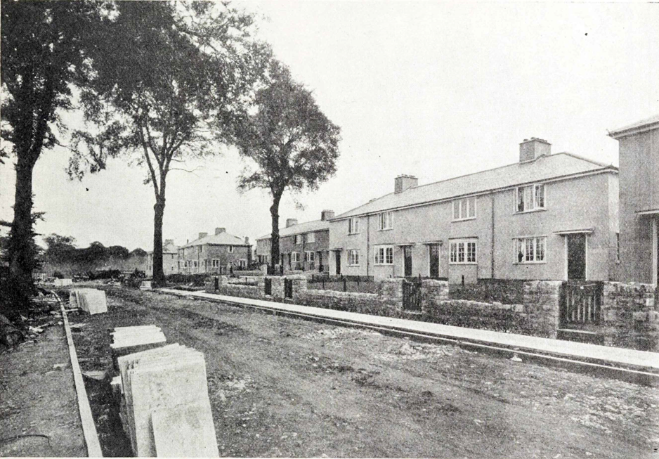
The following year the first of the new houses had been completed at the far west end of the estate on Kingsweston Avenue. These were built with the financial support of the Ministry of Munitions who had large mustard gas factories and shell production at Chittening, the National Smelting Company having to step-in in 1919 to complete 150 of the dwellings. These dwellings were more utilitarian than most Garden City architecture, possibly through the necessities of the wartime situation, but enjoyed being interspersed between the existing mature trees of the estate, and were well built and spacious. Stone was supplied from a reopened quarry on Penpole Point and brick from sand dug nearby. The quarry was to become a rock garden in the final scheme, and the cavity left by the sand pit a swimming pool.
Kingsweston Avenue photographed during construction in 1918.
After the cessation of hostilities, and the closure of the mustard gas factory, the urgency of the endeavour dissipated. The ambitious plan set out across the whole of the Kings Weston parkland was quietly abandoned only part realised, like Napier Miles’s previous Garden city projects. By this time his interest had already been diverted to Sea Mills where Bristol Corporation sought to develop their own garden suburb on his land, and the development of the Kings Weston Garden City was quietly dropped. What had been built was eventually purchased by the council in 1924.
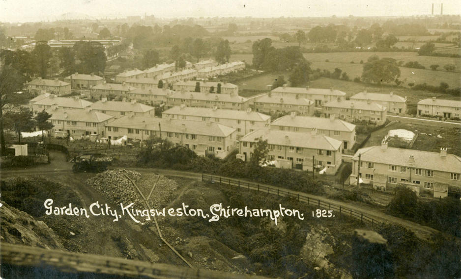
Looking down on the first houses from Penpole Point, circa 1919. The quarry in the foreground was reopened specifically to provide building material for the Garden City.
As a postscript to the Kings Weston Garden City plan, it’s interesting that after the end of WWII attention focussed again on the area, and new plans drawn up that were not dissimilar from those of 1917. Certainly the outline plan of an elongated estate, covering a similar area to Culpin’s original plan were closely comparable, along with the general alignment of some roads. The ambition to provide high quality workers housing, with generous green space and well-integrated community and social facilities was also fundamental to the Council planner’s proposals, though regrettably without the swimming pool, theatre, and hospital that were intended to augment the original plan!
During WWII Kings Weston house was requisitioned from the trustees of Bristol Municipal Charities by the Government. It’s been difficult to establish exactly what was happening at this time, both in the parkland and particularly in the mansion itself. With the obvious need for secrecy at the time there are scant records of what was going on. The concrete bases of Nissan huts along the South Walk remain the most tangible reminder of wartime use, but occasionally things turn up that add more to our knowledge; Such a new addition appeared just recently.
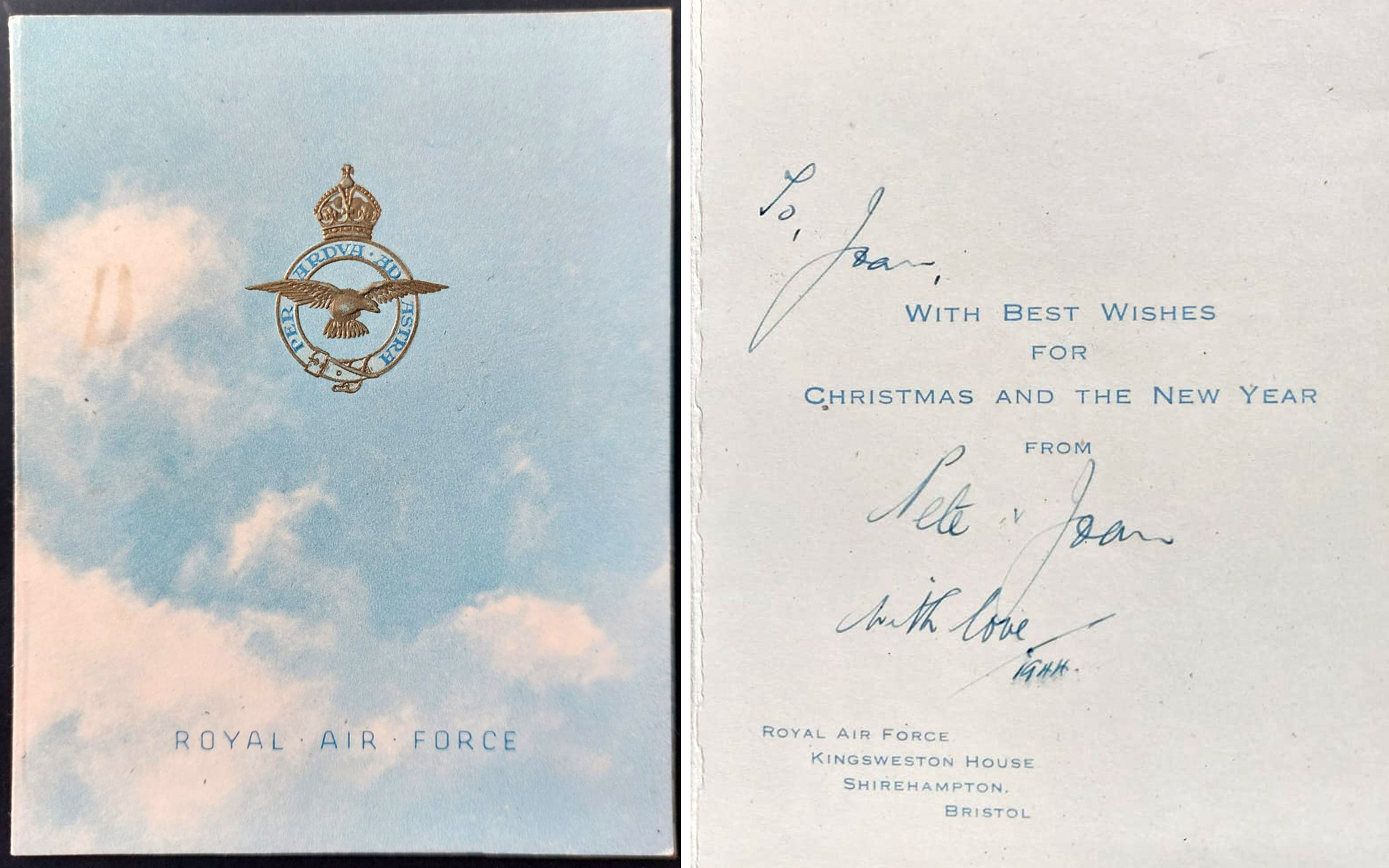
Front and inside of the 1944 RAF Christmas card from Kings Weston house.
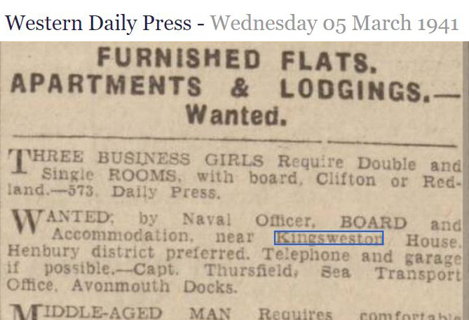
Evidence that the Navy Sea Transport Office were using the mansion in 1941
A Christmas Card, of all things, now established the RAF at Kings Weston. An odd thing to find during wartime privations, the card includes the embossed crest and motto, “”through adversity to the stars”, on the front with stylised blue sky and clouds as a background. The inside includes the printed address of the RAF and Kingsweston House, Shirehampton and helpfully the date 1944, towards the end of the war.
Whilst a lovely find, this adds further confusion to how the house was being used. We’ve already found evidence of Navy officers and the army working here, but this adds another service! If anyone can shed light on what was happening here we would welcome it.
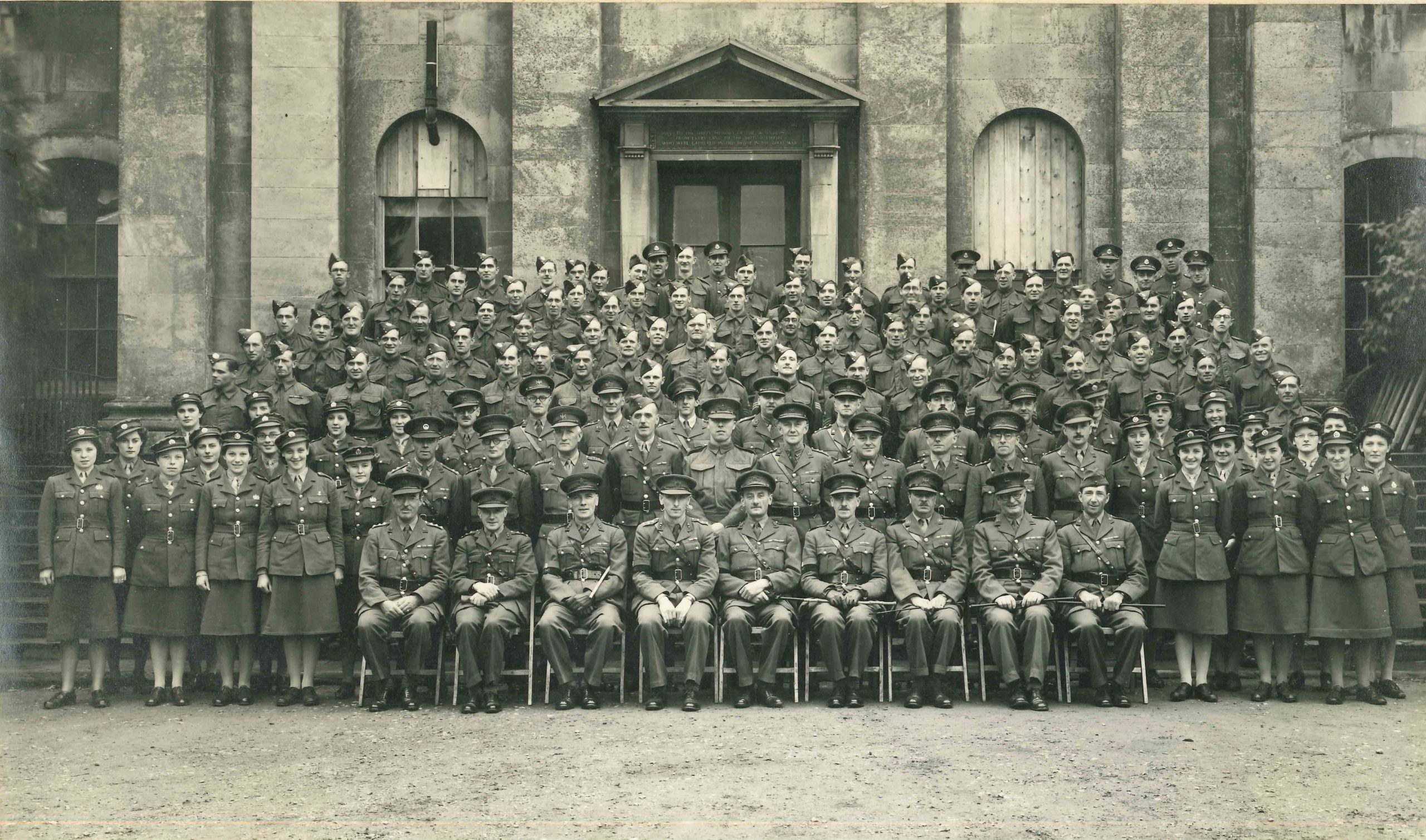
Army troops lined up on the front steps of Kings Weston during WWII. Note how the windows were protected.
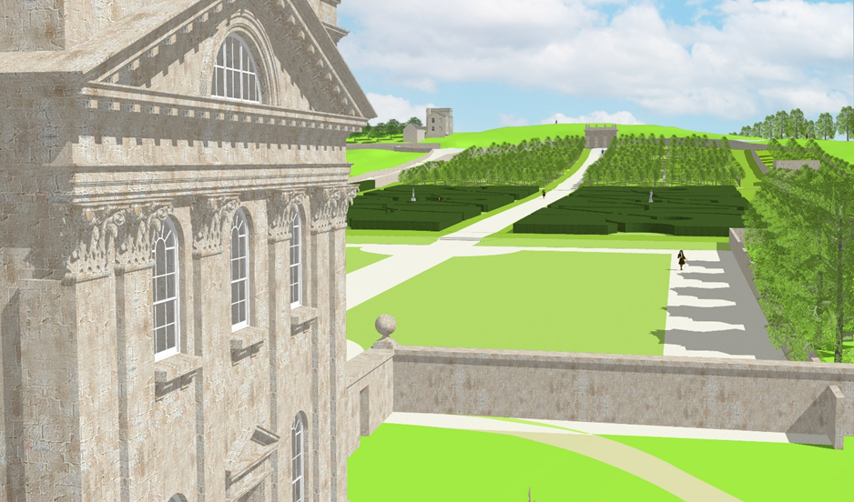
We’ve been working on a better understanding of the formal gardens between the house and Echo as they were first designed. We’ve explored them using a 3D computer modelling. This allows us us to integrate the modern topography of Kingsweston Hill with the known historic plans and illustrations of the garden, bringing a new perspective on their original appearance. Whilst it’s important to make sure that the plans and terrain are modelled to the correct scale, an understanding of how the gardens evolved has been essential in recreating them.
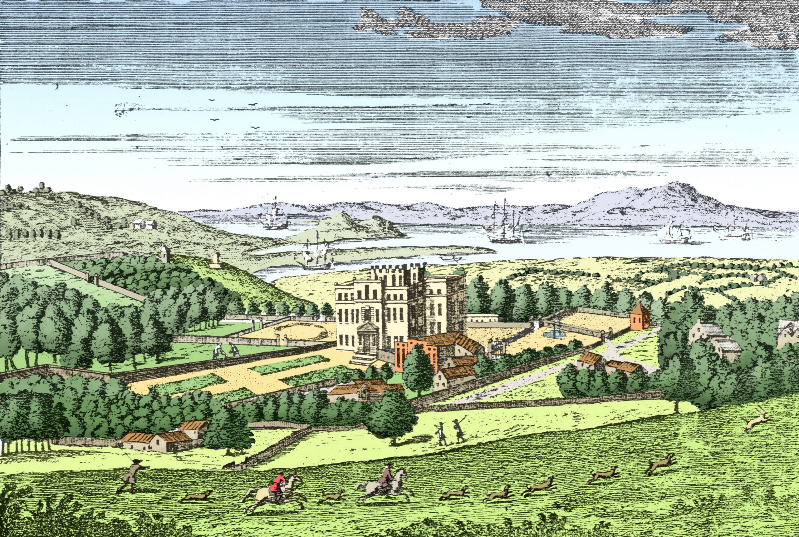
An engraving of the garden side of the house in about 1720, with modern colourisation. Source unknown.
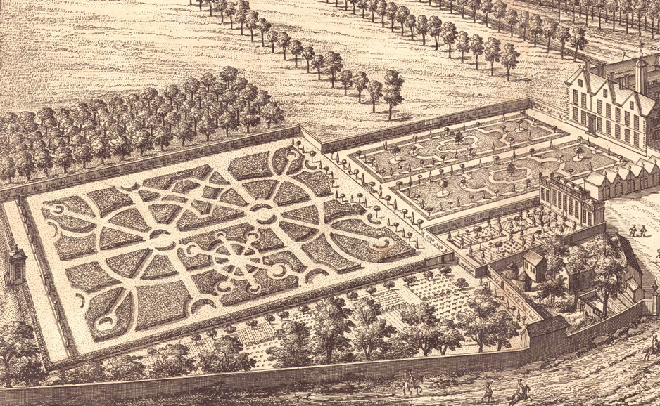
We know that in 1716, when Edward Southwell, Neddy, moved with his second wife into the new Kings Weston house for the first time, the gardens in which it sat were little changed from when his father had laid them out in the 1680s around the previous building. Sir Robert, his father, possibly following advice from his good friend John Evelyn, created a series of formal gardens that led up the side of Kings Weston Hill, terminating at the garden wall against Kings Weston Lane; the lane was later realigned but its earlier route passed directly behind the Echo building. Between the wall and the house, the gardens were separated in the European model, into three compartments, a traditional sequence of parterre garden, ‘wilderness’ garden, and formal grove. Two of these gardens are shown in the famous engraving of the house published by Johannes Kip in about 1711, but the third was probably omitted for artistic licence and a greater focus on the mansion itself. Certainly, the formal grove was in place in 1720 when all thee of the series are illustrated on an estate plan.
Two of the three likely gardens at Kings Weston shown in Johannes Kip’s c.1711 engraving.
The three gardens represented an ordering of nature, with this being most strongly expressed in the ornamental parterres closest the house, gradually becoming less formal through each subsequent section, but all connected by a rigid axial path and symmetrically arranged on each side. Each of the gardens was walled-in from the park beyond, so largely isolated from the landscape outside of their narrow parameters – an idealised microcosm of nature.
Closest to the house, the parterres were intended to be the showiest part of the garden. Once planted with rare and unusual specimen plants, manicured ornamental shrubs, and probably flowering bulbs, by 1720 they appear to have been greatly simplified. The expense of maintain such an intricate garden, particularly while the house was a building site, must have been difficult and expensive, and as much evidence as we have suggests it was laid simply as lawn at this date.
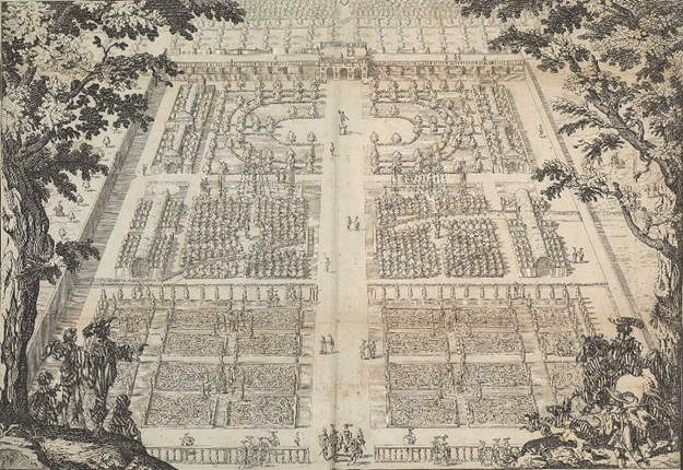
Gardens like that at Wilton House, Wiltshire from the 1630s set the Continental model for gardens that houses like Kings Weston followed.
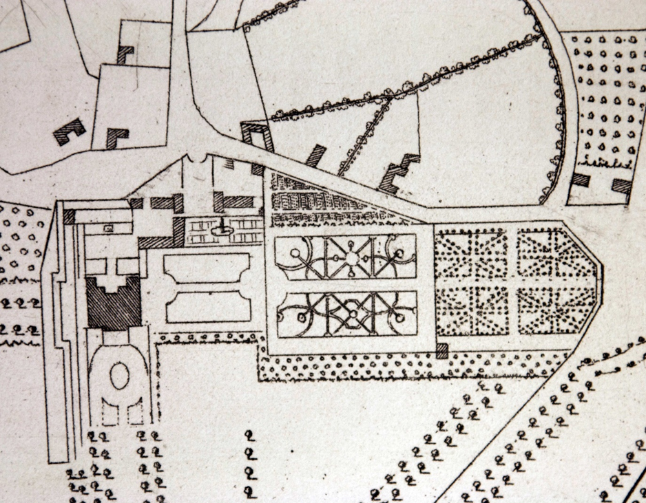
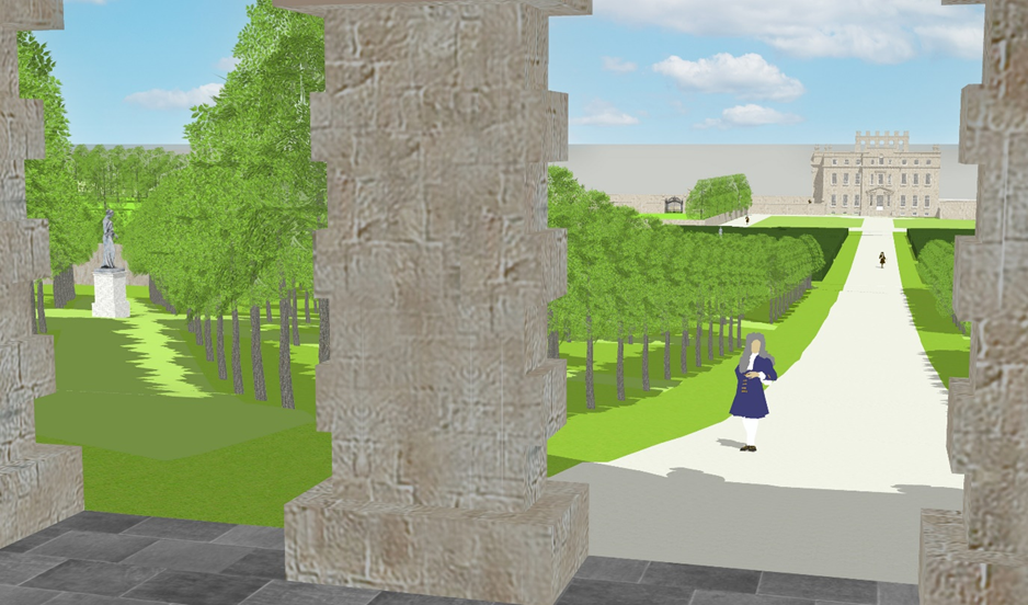
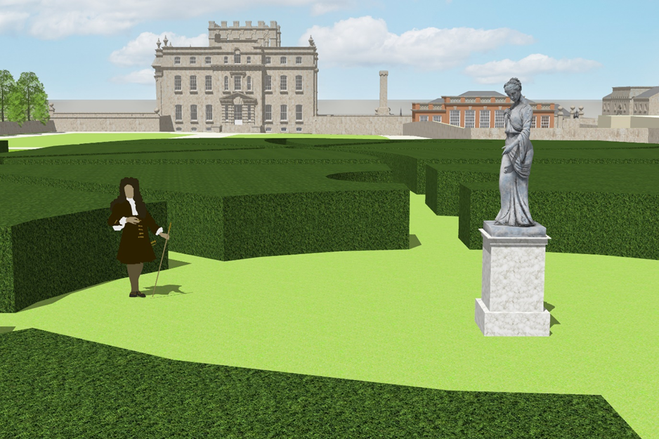
The wilderness garden, the second compartment, was far from what we’d imagine today, a wild unkempt area, but instead it was a geometrically planned series of compartments formed with dense evergreen hedges. These were set out either side of the Echo path and incorporated secluded saloons linked by radiating pathways. Like the famous Hampton Court maze these hedges were maintained at a regular height and profile and were as much an expression of enlightenment order as the parterres. We might assume that the open saloons in this part of the garden were provided with focal points, perhaps the lead statues of Jupiter and Vesta that were later transported to the family estates in Downpatrick by 1749. This garden was planted with evergreens, with yew and holly being popular species for form dense hedges and winter interest. Writing in 1785, Malesherbes described the gardens;
“planted with varied and beautiful trees, but still young, the “allées francaises” having been changed only fourteen years since. A great number of old trees which comprised them have been preserved with great art.”
The allées francaises referred to are the regular paths in this and the final part of the garden, a design that had originated on the Continent. It’s likely that the surviving ancient holly tree beside the Echo Path, and perhaps some of the yews nearby, are the same trees that once formed the wilderness garden.
Detail of William Halett’s estate plan of 1720, showing the three garden compartments surviving from an earlier era.
The last of the three gardens was a formal grove, or rather four groves, each planted with a star shaped radiating pattern of trees. This would have provided a shady place to walk during the summer months, and may also have been decorated with statues or other architectural features at key points. At the time of the 1720 estate survey it’s not clear how the garden terminated against the boundary wall at its southern extent. The Echo pavilion is part of a series of buildings added only after that date, but it would be extraordinary if there were no focal point to attract the visitor’s eye. The survey suggests that there may have been some sort of raised terrace with ramped access down either site that would have enjoyed elevated views back towards the house and to the Severn Beyond, but this is only speculation.
A view across the front of Kings Weston House with the three garden compartments stretching out along the path to the Echo.
After the publication of the 1720 estate plan, Neddy Southwell returned to his architect, Sir John Vanbrugh, and commissioned a series of new garden buildings to ornament his estate. The new works included the Echo and Kings Weston Inn on the hill beyond, both from around 1724-28. As part of our reconstruction these buildings have been inserted into the earlier garden layout. Also modelled is the original profile of Kings Weston Hill, much higher behind the Echo than today, with 30 feet of rock removed a decade later mound of Kings Weston Hill between them as it was before being quarried away in 1731. What’s immediately apparent is how prominent the Inn would have been, enjoying a belvedere position looking across the gardens, with a central tower that was, no doubt, used as a viewing platform. Another striking feature is the impact of the original hill profile behind the Echo, and how it dominated the Echo in front of it, no doubt one reason behind it’s expensive and laborious removal. Although the view is changed today, it’s still possible to imagine the urns on the Echo once creating an ornamental silhouette against the sky, and whilst the was Vanbrugh’s original ambition, the hill beyond robbed the Echo of its full impact for a number of years.
The reconstructed view from the Echo, with the aligned views through one of the formal groves of trees and the central axial path framed within Vanbrugh’s arches. A statue may have ben an eyecatcher in the centre of the grove.
Modelling the original gardens in 3D also reveals another intriguing aspect of the design. When viewed from within the Echo, each of the three arches framed a different view. The central arch remains aligned on the path to the house today, but the outer arches appear to relate to the tree-lined paths radiating out into the formal groves.
It’s unlikely, of course, that we will ever know exactly how the gardens looked, felt, or smelled, but in putting together the evidence we can at least get a sense of them in their prime. The scene today it different, with maturing woodland and new formal gardens on the south of the house. Although the Echo remains, as a focal point of the original design , there are no plans to turn the clock all the way back to the 1720s.
Looking up towards the Echo from the wilderness garden. The line of the hill behind is higher than it is today, and Kings Weston Inn on the left is no longer visible behind trees. The formal groves of trees are planted on the rising ground beyond the end of the wilderness garden. A statue may have stood in the centre of the largest of the wilderness garden saloons. The lost brick-built orangery stands beyond.
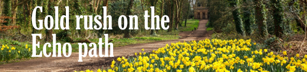
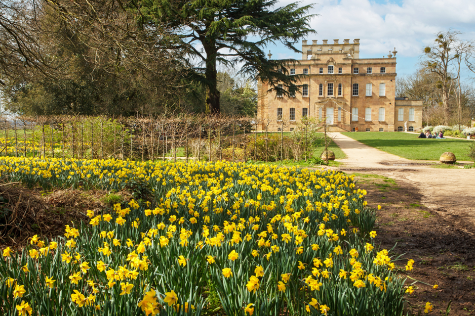
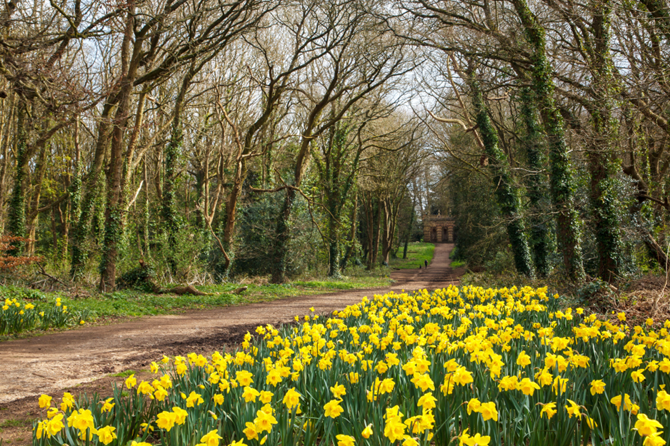
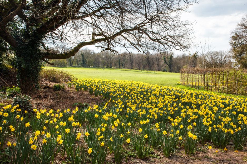
There’s always a long wait to see whether our annual Big Bulb Plant pays off. In October last year we planted thousands more daffodils on the path to the Echo from the house and we’ve been waiting expectantly to see the results. A bit behind flowering compared with previous year’s planting it’s just come into its prime, and the results are pretty sensational!
The house with its new foreground of Spring gold
The flowers now form a beautiful Spring welcome into the park from the house car park, attractive foreground interest to both the house and the Echo, and an eye-catching sight across the lawns. Since we cleared most of the bramble and nettle roots out from the area it’s left it rather bare below the bulbs, so we’ve scattered grass seed across the area to take over when the flowers die down.
The Echo path, now lined with flowers. Daffodils now welcome visitors from the Woodland car park onto the lawn.
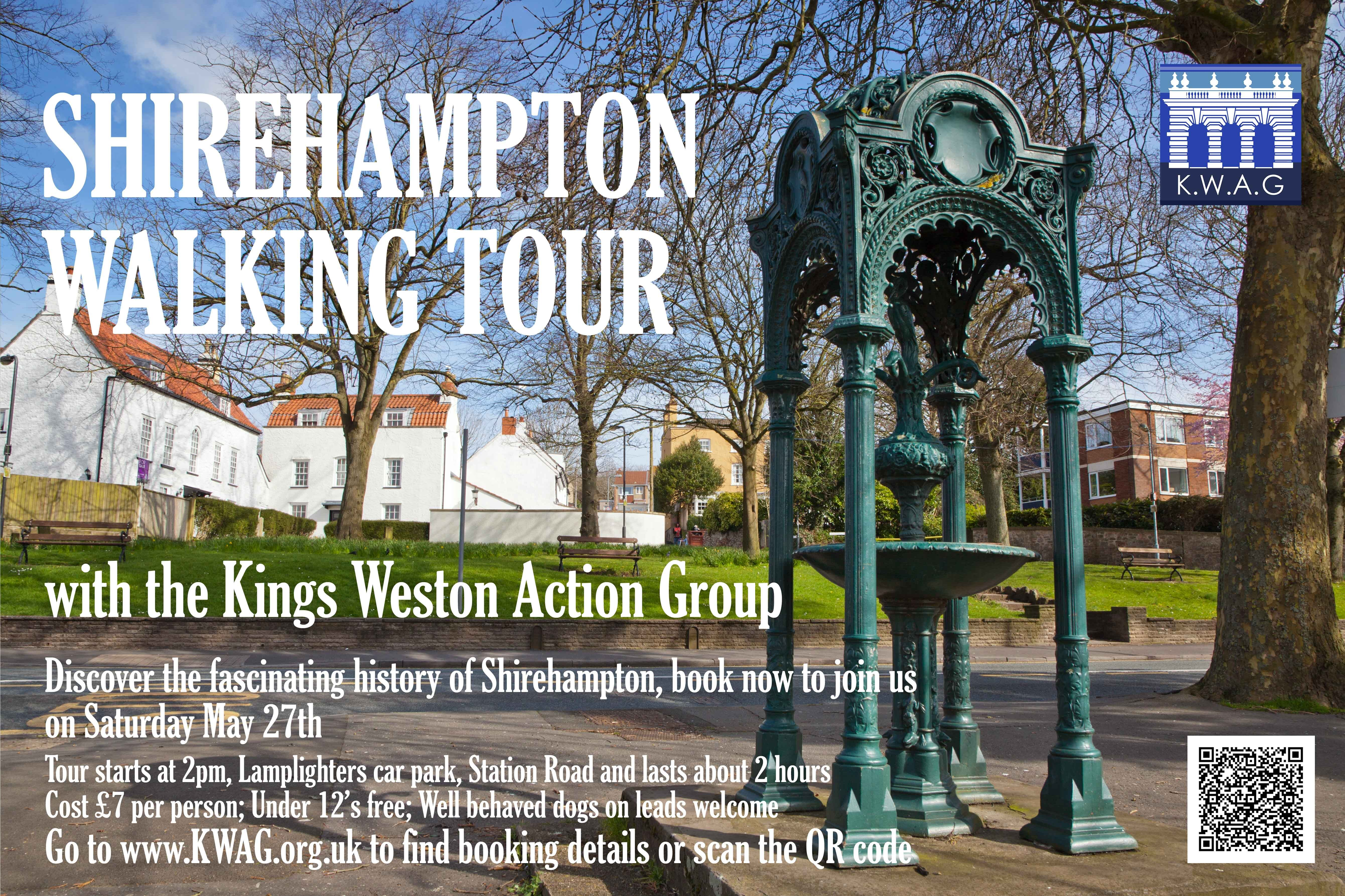
The history of the village of Shirehampton is inextricably linked to the Kings Weston estate. A new Conservation Area character appraisal has recently been adopted by the council, almost doubling the area now protected by the designation and setting out its historic character and significance. In celebration of this relaunch of the Conservation Area we are planning to give a guided tour of “the village” taking in all of the old, and newly added, areas as well as a generous helping of Kings Weston history.
The walk will be led by our Chair, David Martyn, and take place on Saturday May 27th. The walk will cost £7 per person, with all proceeds going towards KWAG’s work on the parkland. The tour will set off from Lamplighters car park on Station Road at 2pm and take around 2 hours. It will take in everything from regal arrivals at Lamplighters to the Georgian Green, look at the fascinating history of the Bristol Garden Suburb as well as many of the historic buildings surviving in the area.
If you’d like to join us on this walk you will need to book a place as numbers need to be limited. If there is enough interest we will keep a stand-by list and possibly schedule another in the future.
KWAG members like you have preferential booking before wider advertising of the event, so book your ticket head over to booking website. Please check out our poster and if you have anywhere to put one up please let us know.


