

In many ways this piece follows on from last months article about the original interior of Vanbrugh’s Kings Weston house. It comes after we discovered another mansion, Gloster House, in Ireland, with some interesting similarities. The architectural history of England and Ireland are rarely studied together, yet national distinctions were less prominent during the Eighteenth Century when the two kingdoms fell under a single ruler.

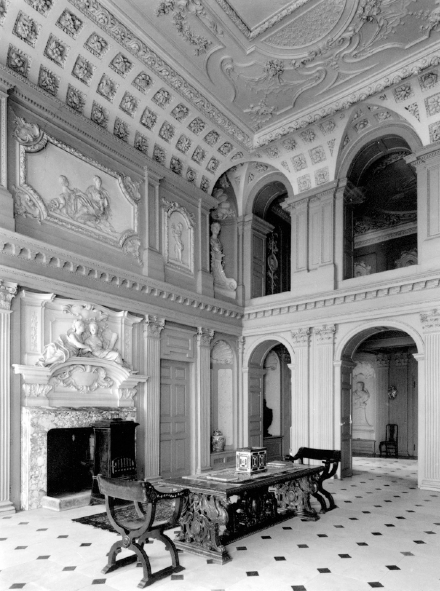
Gloster House, County Offaly, is a long low-lying mansion built from around 1700 onwards. The two later wings rather upset the balance of the original nine-bay façade in the middle, an exterior that perhaps looks a little earlier than what lies within. Entering through the front door there is a spectacular double-height space and immediately in front of the visitor are two tiers of arches, the upper being an open gallery like that which once existed at Kings Weston. The main hall gives onto an inner hall from which a pair of staircases take you up to the gallery level from where views back into the hall can be enjoyed. Alcoves line the side walls in a similar way as drawings suggest was the case at Kings Weston. There are some key differences of course, there are no fireplaces in this space, and the overall impression is more decorative and ornamental than similar spaces designed by Vanbrugh.

These works at Gloster House, dating probably to the 1720s, have been attributed to perhaps Ireland’s most important architect, Edward Lovett Pearce. He’s a figure we’ve brought into Kings Weston’s story before. Born into an Irish family, Edward was a cousin of Sir John Vanbrugh and, at 16 years old, was apprenticed to him after the death of his own father in 1715. This was a period during which Vanbrugh’s office was still overseeing works at Kings Weston. Whilst other works would have become familiar to the young pupil, it appears as though Kings Weston’s interior made an impact.


After a brief time in the army in 1717 Lovett Pearce returned to architecture and to his homeland. It is during this early period that the Gloster House work is supposed to have been completed. The similarity between the lost Saloon at Kings Weston what Pearce later achieved in Ireland is most marked. Pearce increasingly moved away from Vanbrugh’s Baroque style to the developing Palladian movement, but at Gloster House he combines Vanbrugh’s dramatic and playful use of space with more modern ornamentation. The tight cage of stone arcades constricting the staircase that was built at kings Weston is transformed in Gloster House into a light open gallery with a single freestanding colonnade and classical-inspired vault.
Gloster House is not the only building that seems to owe Kings Weston its inspiration. Dated 1720, a design for stables survives in the Kings Weston Book of Drawings authored by a Mr Price. Although this is the only known reference to this gentleman it shows he was a competent architect. Though the context in which the drawing was created are not known, Mr Price is likely to have been familiar enough with Kings Weston to be able to supply designs complementary enough to Vanbrugh’s house. It’s likely that Price was “John Price of Richmond” (sometimes “of Wandsworth”). Price has the strongest claim to be architect of Barnsley Park, Gloucestershire, where works were ongoing in 1720.

Just a glance at the entrance front of Barnsley Park and one can see similarities. The composition of the temple frontage, bold keystones, arched windows, weighty attic storey and pediment all feel familiar. The other elevations are all entirely different, a feature shared with Kings Weston, but entirely individual in character. We have to go within to see how exposure to the unique Saloon of Kings Weston might have translated into Price’s work. The entrance hall repeats Kings Weston’s double-height space and uses an open arcaded back wall to introduce a dramatic visual connection between it and the inner hall and gallery beyond. Unlike Kings Weston or Gloster House, the inner hall isn’t a showcase for a grand stair, this is set off to one side. Another oddity is that the first floor gallery doesn’t take advantage of the open arcades for a grandstand view, instead allowing the arches to stand as little more than a room divider. Instead, the gallery bridges the inner hall along its back wall.
The ceilings to the two halls at Barnsley Park are the reverse of the arrangement at Kings Weston; the heavily coved front Hall is like the one formerly in the stair hall at Kings Weston, and the flat ceiling with a central oval compartment more like the surviving Saloon ceiling. Could the coved ceiling existing at Barnsley Park show us what might have been lost to the Victorian refurbishment of the stair hall?
Like Gloster House, much of the effect at Barnsley Park arises from thickly applied decorative embellishments rather than simple architectural form, and, in that, they likely differ from Vanbrugh’s intentions at Kings Weston. This was a building Vanbrugh referred to as a “chateau” and clearly hoped it would assert a masculine, martial, presence on landscape and occupants alike. This perhaps proved to be the undoing of the Saloon and stair hall. No longer in line with the developing direction in architecture, lacking in domestic comforts, and otherwise inhospitable, it’s unsurprising that they were remodelled by later generations. However, these two surviving interiors, one by Pearce and the other by Price, might allow us a glimpse of what was lost.


