Tag Archives: Town Planning

Kings Weston Garden City – A forgotten dream

Four years ago we wrote a piece on the Garden City aspirations of the last private owner of Kings Weston estate, Philip Napier Miles. Now further evidence has come to light that show his enthusiasm for innovations in town planning and promoting the development of his lands for socially progressive housing

Philip Napier Miles and his French Bulldog, Hippo in the library at Kings Weston in 1926

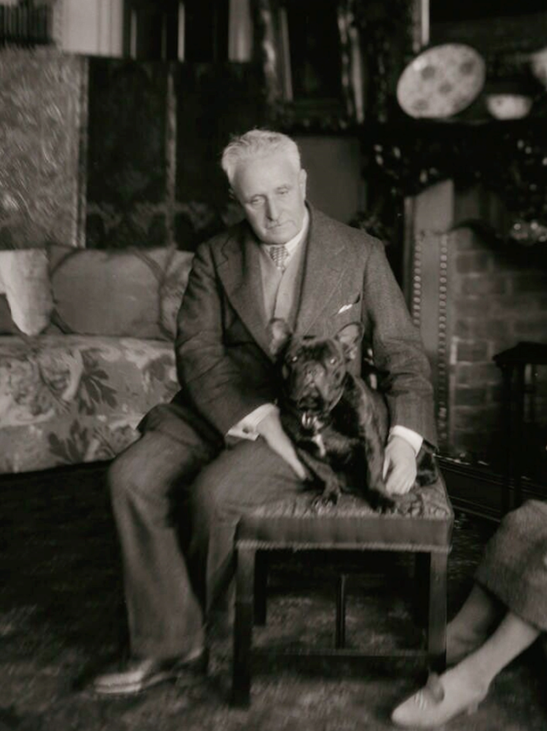
From the moment he inherited the estate from his father in 1881 Napier Miles seems to have been keenly focussed on making the best provision for his tenants and building new homes and facilities for their benefit. Beginning with new streets in Avonmouth he set out some of the best workers housing in the city, before becoming an early adopter of the revolutionary principles of the Garden City movement for new building. The movement promoted the idea that bringing together the best features of the town and countryside would provide the working class with an alternative to farm working or crowded unhealthy cities. All industry, housing, commerce could be provided interspersed with generous greenspace and allotments, and with key facilities to support education and social development.

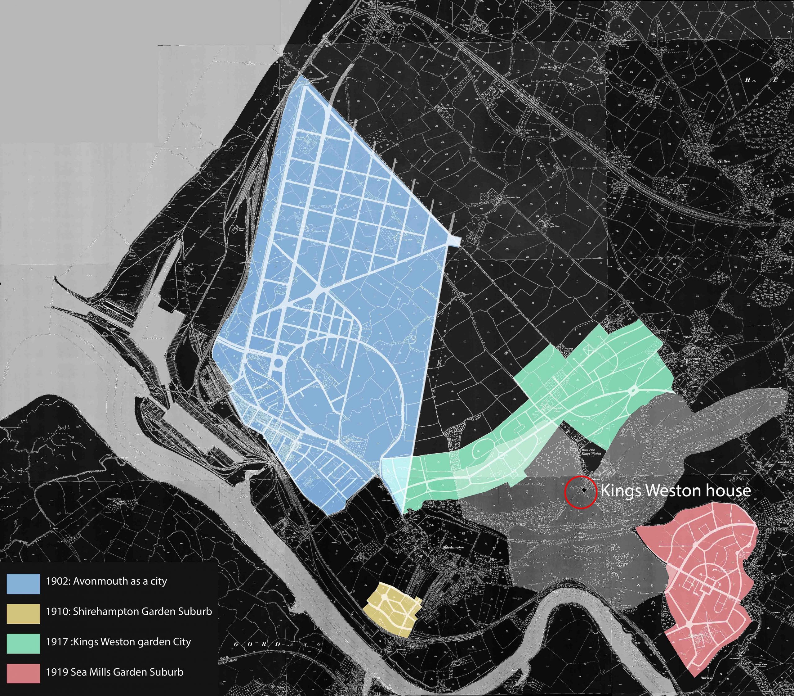
Miles’s initial project to create a new city around Avonmouth began around 1902 but faltered despite having achieved a lot of high quality new building there.  A smaller endeavour was endowed with land at a beneficial rate in Shirehampton in 1910: the Bristol Garden Suburb. Another ambitious plan for development was promoted by Miles in 1917 for the land immediately below Kings Weston house where the Lawrence Weston estate lies today. The main emphasis of the plan was to provide urgently needed housing for labourers at the recently built national Smelting Company zinc works in Avonmouth, and serve the urgent wartime demands. A Public Utility Society was created in partnership with the management of the zinc works, Ernest Bevin of the Dock Worker’s Union, Napier Miles, and other local dignitaries and business owners formed a committee.

A diagram showing the scale and distribution of  Napier Miles’s Garden City projects 


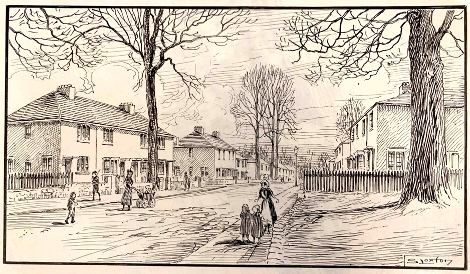
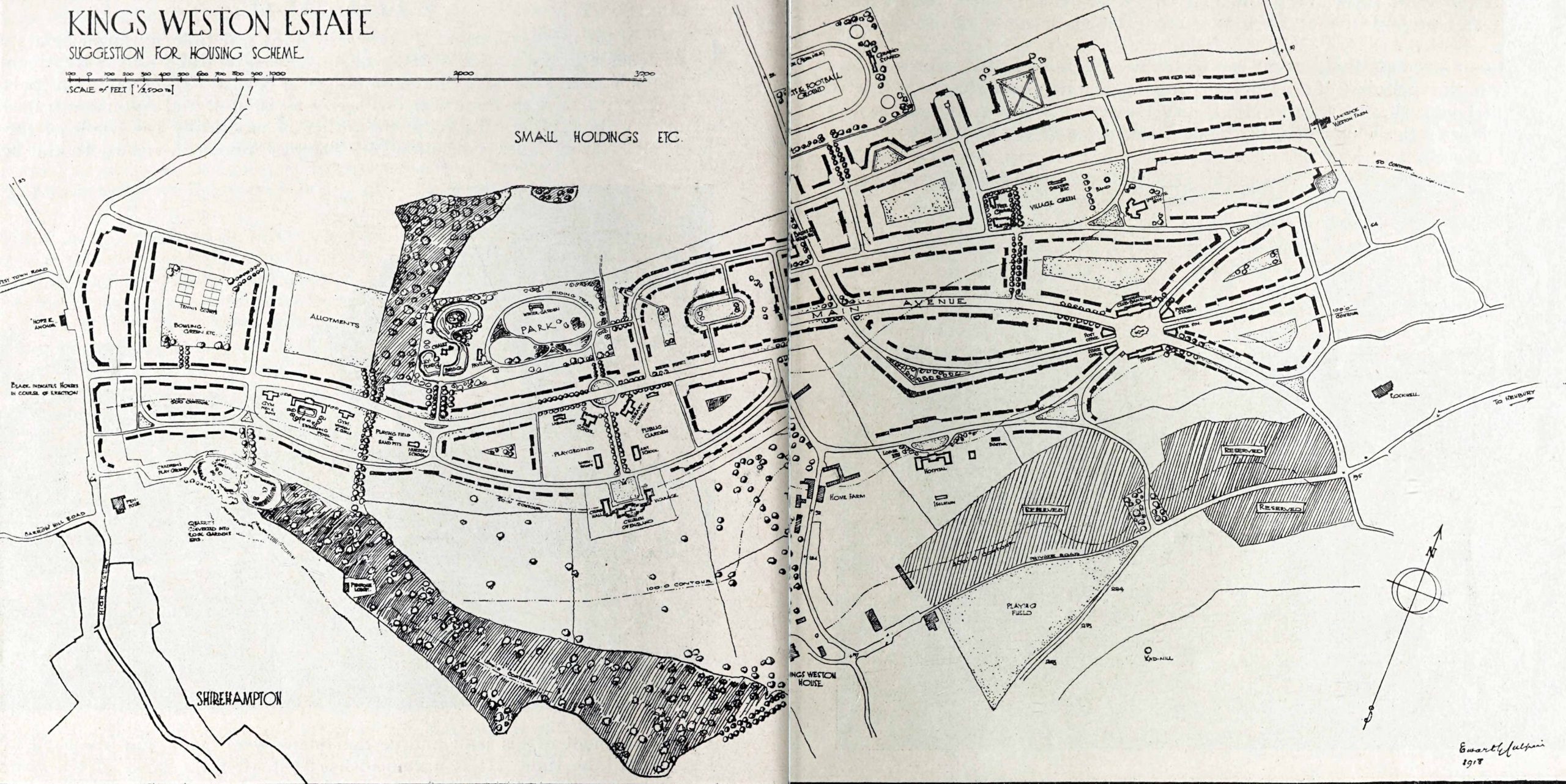
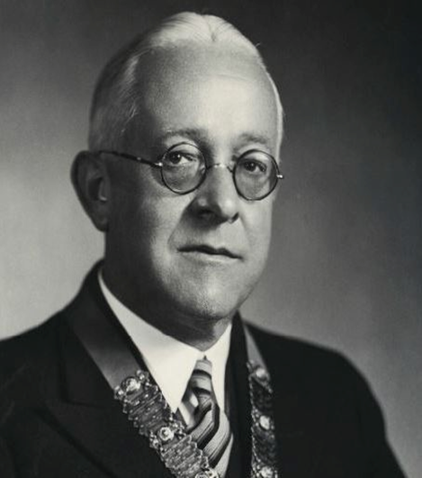
On the 15th May the committee met to discuss plans. Napier Miles provided a venue for a meeting between interested parties, under one of the giant beech trees in the garden of Kings Weston house. Ewart Culpin of the Garden City & Town Planning Association, a figure of national importance, provided a sketch layout of a 271 acre estate which, it was projected, could accommodate around 2000 homes for up to 150 thousand people. The plan was set out on Garden City principles with emphasis on green spaces totalling around 60 acres, and tree-line avenues, along a central spine road that approximated todays Long Cross.  Progressive public and social facilities such as communal kitchens, wash houses,  & laundries were designed in, along with land for a Trades Hall, schools and a hospital. On the western part of the estate were planned the social and educational centre, the church, schools, and other public buildings. A theatre, concert hall, Swimming pools gymnasium & allotments were also projected. It was described as having “more of the elements of a real garden city than in any other proposal since Letchworth”

The 1918 published sketch of the plan for Kings Weston Garden City, unfortunately with the house hidden in the fold between pages. The houses that were completed are on the far west side. 

Co-operation was an imbedded feature of the organisation. Tenants were to become shareholders in the scheme with a vested interest in the estate. Napier Miles “in alluding to his sympathy with this movement, said he had strongly opposed the erection of buildings of such a nature and would in a few years become slums” and the design of new houses ensured good space, light, and access to generous gardens.

Edwart Culpin, 1877-1946  president of the Town Planning Institute

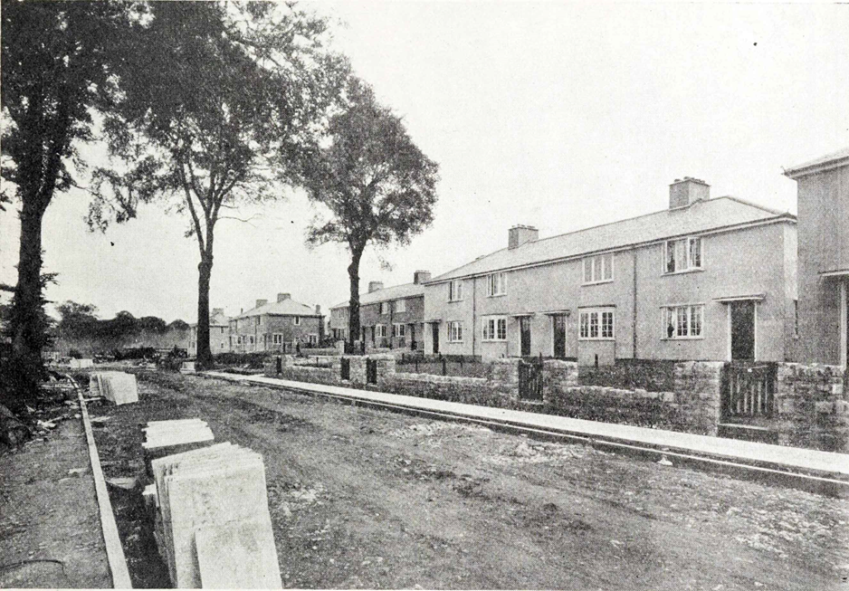
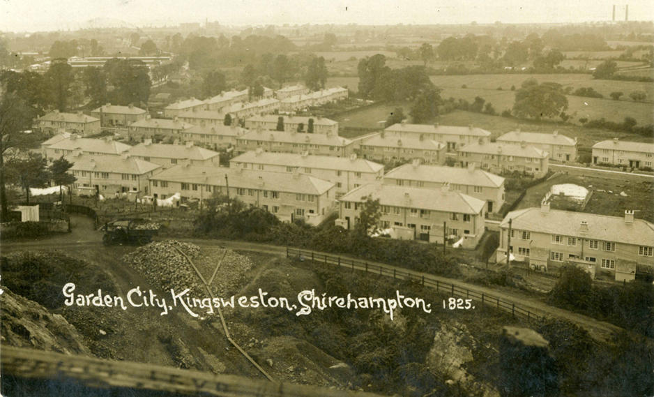
The following year the first of the new houses had been completed at the far west end of the estate on Kingsweston Avenue. These were built with the financial support of the Ministry of Munitions who had large mustard gas factories and shell production at Chittening, the National Smelting Company having to step-in in 1919 to complete 150 of the dwellings. These dwellings were more utilitarian than most Garden City architecture, possibly through the necessities of the wartime situation, but enjoyed being interspersed between the existing mature trees of the estate, and were well built and spacious. Stone was supplied from a reopened quarry on Penpole Point and brick from sand dug nearby. The quarry was to become a rock garden in the final scheme, and the cavity left by the sand pit a swimming pool.

Kingsweston Avenue photographed during construction in 1918.

After the cessation of hostilities, and the closure of the mustard gas factory, the urgency of the endeavour dissipated. The ambitious plan set out across the whole of the Kings Weston parkland was quietly abandoned only part realised, like Napier Miles’s previous Garden city projects. By this time his interest had already been diverted to Sea Mills where Bristol Corporation sought to develop their own garden suburb on his land, and the development of the Kings Weston Garden City was quietly dropped. What had been built was eventually purchased by the council in 1924.   

Looking down on the first houses from Penpole Point, circa 1919. The quarry in the foreground was reopened specifically to provide building material for the Garden City. 

As a postscript to the Kings Weston Garden City plan, it’s interesting that after the end of WWII attention focussed again on the area, and new plans drawn up that were not dissimilar from those of 1917. Certainly the outline plan of an elongated estate, covering a similar area to Culpin’s original plan were closely comparable, along with the general alignment of some roads. The ambition to provide high quality workers housing, with generous green space and well-integrated community and social facilities was also fundamental to the Council planner’s proposals, though regrettably without the swimming pool, theatre, and hospital that were intended to augment the original plan!

A copy of a contemporary 1918 account of the Garden City can be viewed here: https://mcusercontent.com/d6754e0d3b18e9a31be2d62e5/files/df84c99a-aefe-509b-d2e6-7a0e1dfb2210/Binder1b.pdf

A drawing by Samuel Loxton looking west along Kings Weston Avenue, towards Lower High Street.


Lawrence Weston – a legacy of estates 

Looking north from the house today it’s difficult to reconcile the Lawrence Weston housing estate with the Kings Weston historic parkland. The Lower Park on which it was developed was once a key component in the designed landscaped grounds, dropping away to reveal the spectacular views across countryside towards the Severn, and acting as an artificially picturesque setting for the house in the opposite direction. It’s harder still to conceive that the designers of the post-war estate acted with sympathy to the historic setting they were provided with.

The Lower Park seen from Kings Weston house in 1789, by Samuel Hieronymus Grimm. Penpole Point is recognisable in the distance, with the lodge tower and stone dial. 
Cast concrete Easyform houses are erected on Mancroft Avenue. The angle of the photograph is not too dissimilar from the above painting. 

Immediately after WWII there was a housing crisis that dwarfs the scale of todays. Swathes of Bristol homes lay in rubble, others were unsanitary and decaying slums, and an influx of servicemen returning from war exasperated an already difficult problem. Just a year after the end of hostilities squatters were already taking up residence on some of the abandoned army huts elsewhere on the Kings Weston landscape. Recognising the urgency of the problem the city Corporation took the decision to lay out a large new estate to the north of the city, across the Lower Park of Kings Weston. The Scouts camping fields were acquired by compulsory purchase in 1947 and the rest of the land below the house secured for development.

Although it never hosted any ornamental parkland buildings the land added to the picturesque effect of the estate. By the 1770s it had been laid out in the picturesque Landscaped Parkland fashion, with clumps of trees artfully positioned in the naturally undulating land to frame views or catch the eye. The Tump, a natural hillock immediately to the north of the House, was planted with specimen trees, and some of a much older avenue trees retained and interspersed with these new specimens. Most of these trees remained after the war, and the Capability Brown-style landscaping remained intact.

1947 aerial view of the parkland with north orientated downwards. The open fields, scattered specimen trees, and clustered groups ac all be picked out.
One of the early planning drawings for the estate with north approximately downwards. Sites for a youth centre, pub, nursery school and new schools are indicated. 

Looking at the Lawrence Weston estate today you might think that it was imposed on the landscape without much thought beyond utility, but look closer and you can see its designers were sensitive to the task set of them. The City Architect of the time, Nelson Meredith, was particularly alert to the city’s historic buildings and unique character, and often worked with an ambition to reveal and respond to historic buildings, albeit in a way we might think insensitive today.

In this 1949 photo the flat roofs of the concrete Easyform houses on Mancroft
Avenue reveal the historic mansion above the growing housing estate. 

Meredith’s team of architects and planners set out the road of the estate in a way that maintained unobstructed views up to the mansion from Mancroft and Barrowmead Avenues, and from Long Cross. To ensure that new building had as minimal an impact as possible a flat-roof house type was developed and located where a traditional pitched roof would otherwise have interfered with these protected views.

The designers recognised the importance of the many mature parkland trees on the estate and sought to incorporate them within the overall design.  Where possible they were retained as part of main road frontages, with clumps being given greater emphasis as the focus of new park spaces. Broxholm Walk was aligned to respond to the line of the early Georgian avenue, “Wilcox Avenue” that once linked the house to the Tump, and some of whose trees still survived. The Tump was initially retained as an enclaved vestige of the open parkland, complete with trees an open grassland, though this was, in part, due to the impractical nature of the hilly ground. Today it is part of the Grade II Registered Historic Parkland along with the rest of the estate.

Sadly, over time the mature trees have gradually died and been replaced with more municipal style tree planting. Later houses like those on Sadlier Close have been less sympathetic to views of the house and tree-lined horizons of Penpole Wood. Even those built a short time after the original phases lacked the same understanding of the historic landscape.

Looking west across the Lawrence Weston estate circa 1952, showing the many mature trees and open spaces integrated into its design. Penpole Wood is in the background. 
1948 Roman villa excavations with Mancroft Avenue being built in the background.

The construction of Lawrence Weston did reveal something about the Kings Weston estate, hidden for many centuries: the Roman villa. When in 1947 Long Cross was constructed as the main arterial route through the new housing estate it sliced through part of an important villa dating to the 3rd century BC. Between 1948 and 1950 it was excavated, and the designs of the housing estate adjusted to protect it.

It would once have been the home of a prominent local family who likely depended on a sizable agricultural estate around it for their wealth. The villa faced uphill, southwards, towards what is now Penpole Wood, with an ornamental symmetrical façade. It was furnished with ornate mosaics, its own bathhouse, and later under-floor heating. It’s impossible to know the extent of the Roman estate, but it’s not impossible that ancient land boundaries persisted long after the abandonment of the site in the 4th or 5th Centuries AD, morphed into the Saxon manor, and that Kings Weston house is the direct descendant of the same Roman villa.