Category Archives: heritage

Back to the 90s!

There’s something of a 1990s revival taking over culture right now; baggy combat trousers are back and raves are in again. Frightening to think that it was around 30 years ago! The 1990s was a bad time for the Kings Weston Estate. The house remained in use as the Avon & Somerset Constabulary police training school despite their aspirations to expand across the park being quashed. They already planned to move to Portishead and minimal maintenance was undertaken on house or grounds. The thin sloping strip of Shirehampton Park along Shirehampton Road, between Kingsweston Hill and Penpole Wood, was the only part of the main parkland controlled by the Council.

detail of the aerial photo survey flown over Kings Weston on 30th March 1990 capturing the funfair, tennis courts, and Fairways. 


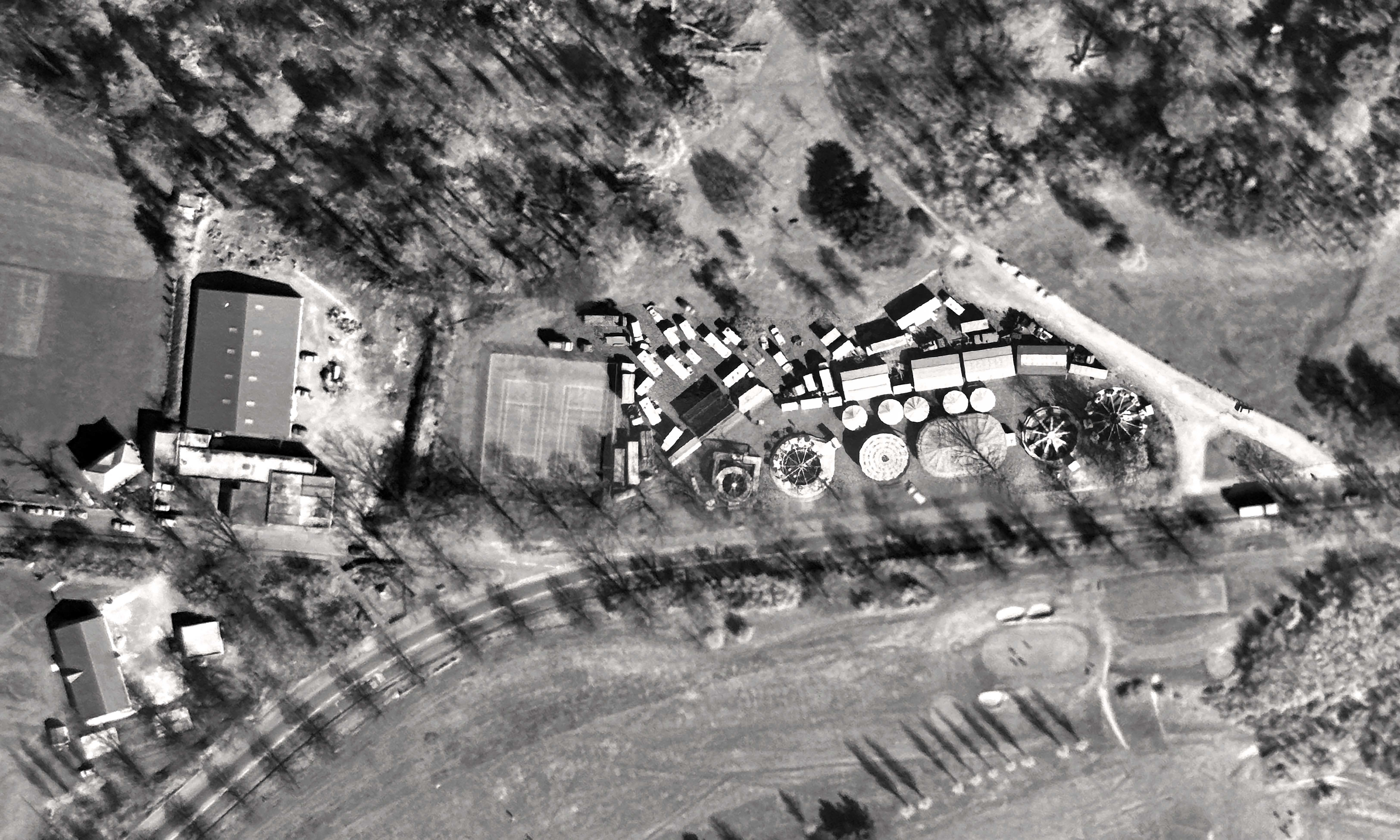
At the start of the decade the Ordnance Survey sent over its survey planes on one of its periodical photography missions.  When it passed over Kings Weston in March it recorded an unusual visitor to the park: a funfair! The fair set up in a prime location on Shirehampton Road, between the Council tennis courts and the car park. It’s possible to pick out dodgems, carousel, and four other big rides as well as a small encampment of stalls, booths, and caravans. Newspapers reveal the fair was here for ten days  from the 21st of March, open 6pm or 2pm on weekends, but no indication of which travelling fair it was. Does anyone remember other times the fair came to Kings Weston, or is this photo a chance record of the only visit?

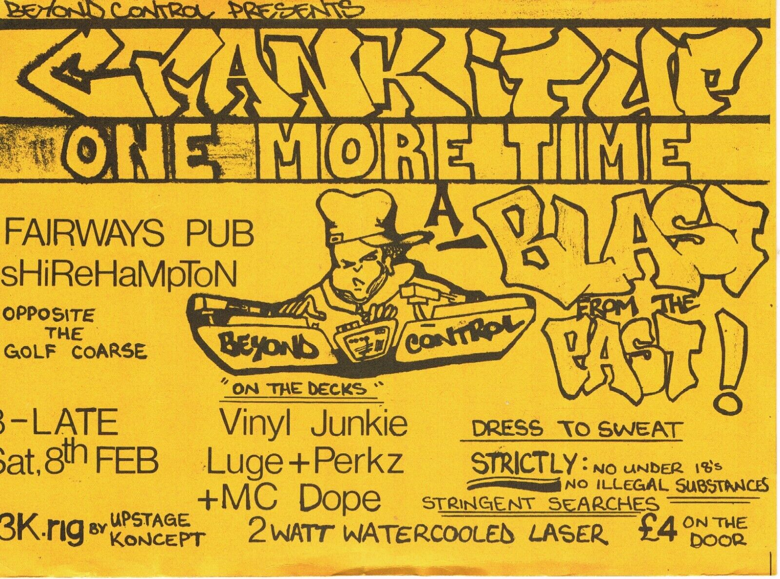
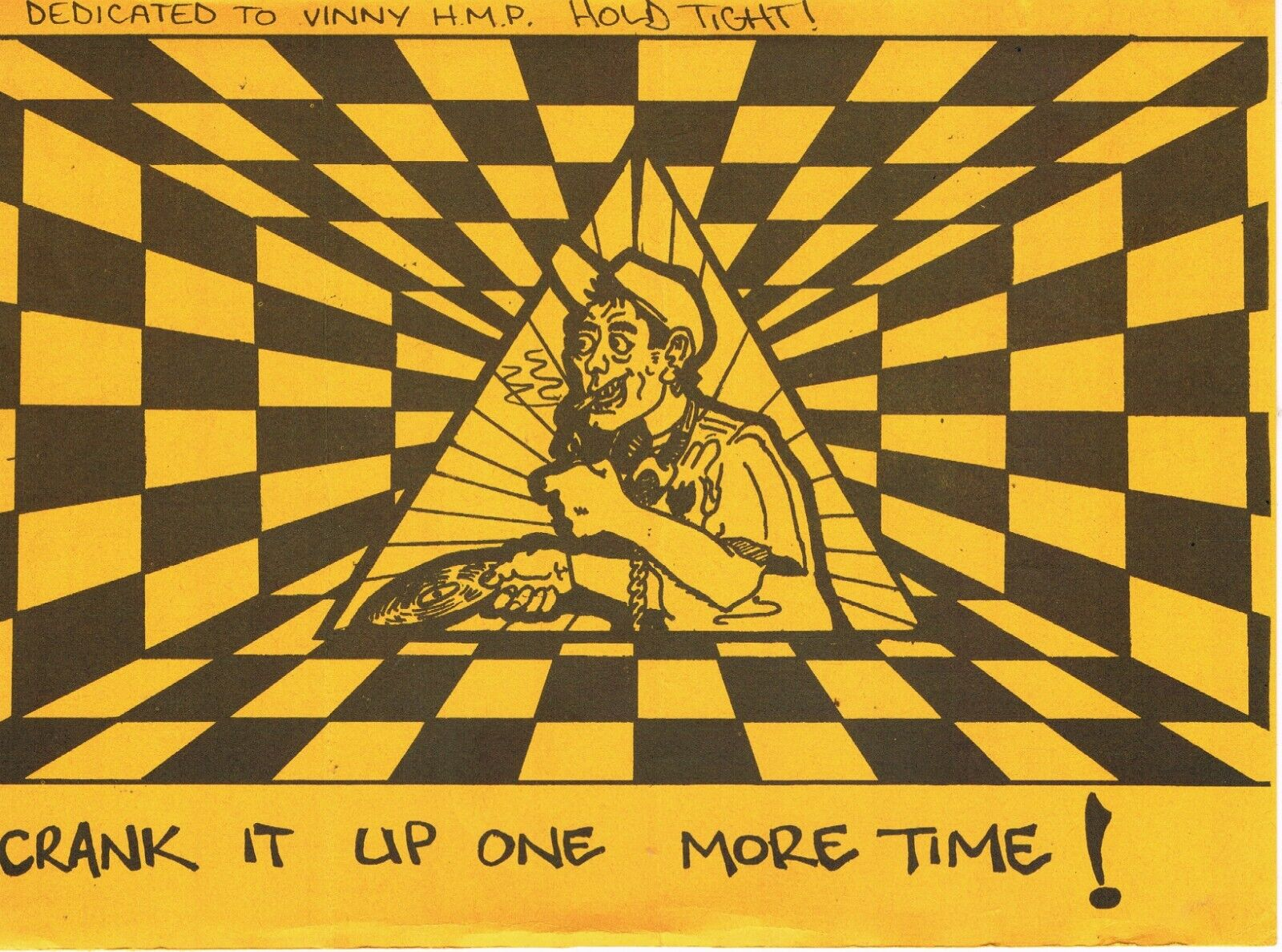
A couple of years later some alternative entertainment was going down on the estate – a rave. Now emblematic of 90s youth culture and fondly remembered by many, raves became a huge civil order issue for the Government. Many were illegally held, but, going by a flyer publicising the event, this one looks to have been more legitimate. In the days before internet and mobile phones in everyone’s pockets, flyers, often handmade, were an essential way to get the message out but rarely survive.  The Crank it Up One More Time session was held at Fairways pub in Feb 1992 and promoted by Beyond Control. On the decks were Vinyl Junkie, Luge+Perkz and MC Dope – where are they now? Guests were advised to dress to sweat.  We’d love to hear from anyone who remembers going!

 An alternative souvenir from the Kings Weston estate in the form of a rave flyer for Crank it UP One More Time 8.2.92

The Fairways pub was just opposite the war memorial, on the present Karakal site. It had begun in the 1972 as a social club for Portway Football club who used the pitch next to the cricket club on Penpole Lane. It was an unglamorous single-storey building erected on land purchased from Bristol Water Works.  It can be picked out in the aerial photo to the south of the old covered reservoir. Its construction coincided with efforts to establish a sports centre in the old reservoir building. By 1988 it was being advertised as Fairways pub, so it appears the football club had relocated to more suitable pitches in Sea Mills by this time. Although planning consent for a replacement purpose-built pub was granted in 1992 the old buildings continued until 1995 when it closed, never to reopen. The run-down buildings were demolished shortly afterwards, but by the time the owners of the site made any move to rebuild it things had changed, the estate was now nationally recognised for its historic value, planning policies had changed, and their new proposals were refused.

 1970s Architects drawings of the sports and social club on Penpole Lane that would become Fairways pub. 

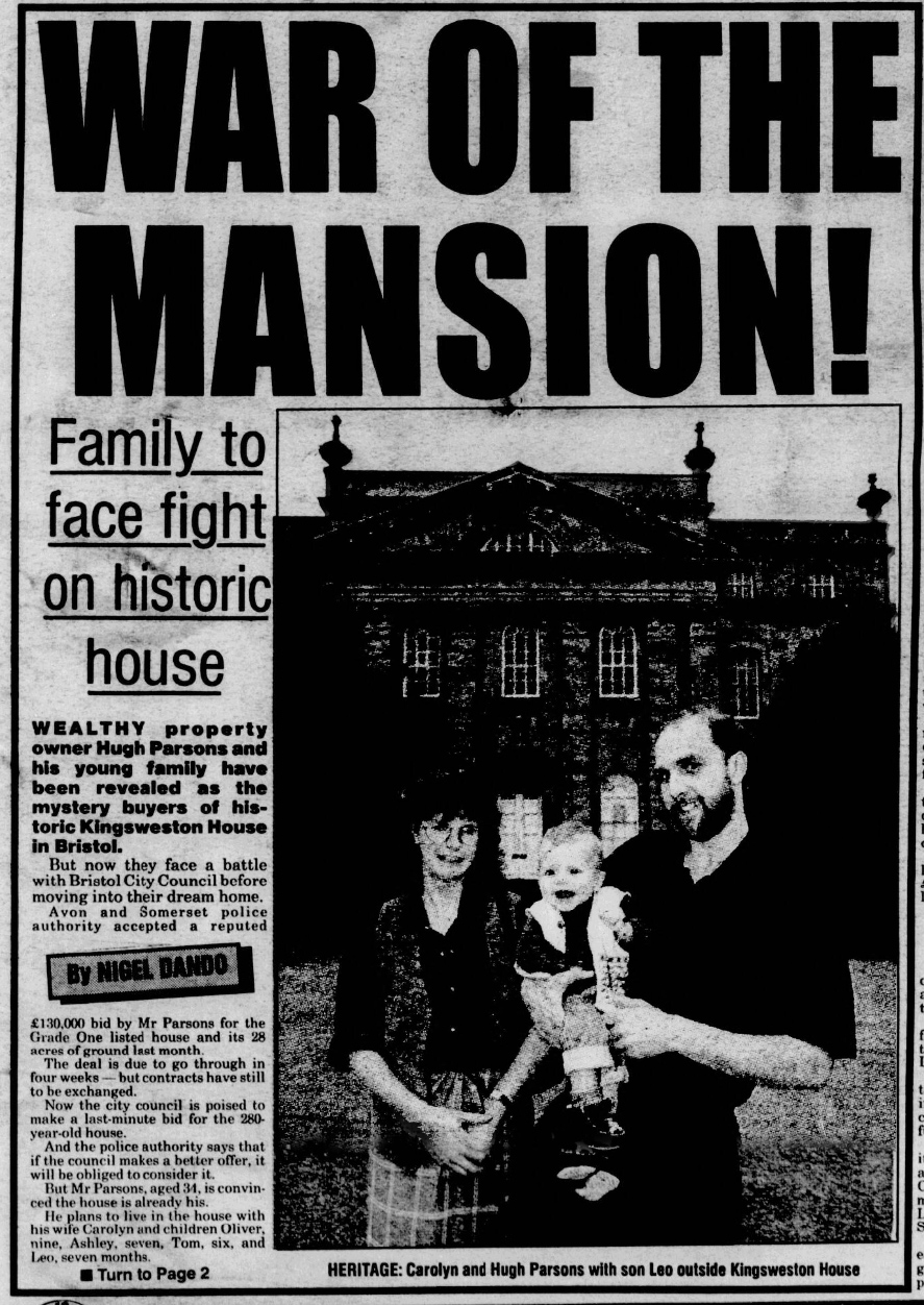
The most significant moment for Kings Weston in the 90s saw the  future of the mansion and Home Park in the balance. Kings Weston house was put on the market by the police in 1995 with an asking price of £300,000. Ironically, this was £30,000 lower than the Council had purchased it for in 1970 before being forced to hand the property over to the police four years later when Avon County was formed. Initial reports in September that year suggested the police had accepted a £125,000 offer from “property tycoon” Hugh Parsons, but late bids were received from a developer seeking conversion to a nursing home, and another from the City Council keen to acquire the land and house for the public; A tussle ensued with legal threats flying. The battle over the bidding played out in the press for several months before it was announced in November that the council finally won with a bid of £300,000 and agreement that public access would be protected. Councillor Paul Smith, chairman of the city council’s land and building committee said: “The challenge for us now is to ensure it is properly looked after and the land kept open to the public”. How that came to pass is another story…

The Bristol press keenly followed the battle over ownership of Kings Weston house. 


An image from the past: Shirehampton Park

Another artwork with Kings Weston Interest has come our way recently. The panoramic views across the waters of the Severn to the north were matched by the rolling landscape framing the Avon and its gorge to the south. Both proved popular locations for picturesque paintings throughout the Eighteenth and Nineteenth Centuries. The recently uncovered work shows the view up the Avon from Shirehampton Park, a spot much-favoured by artists. Here, the view across Horseshoe Bend was attractively framed by trees along the parkland edge. Distant views of Cook’s Folly, a tower with romantic associations, added distant intrigue to the scene.

The painting is likely to date from the 1830s, before the twin towers of the Clifton Suspension bridge rose to punctuate the skyline.  Our artist, whoever they might have been, has added a sentimental vignette as foreground interest. A young couple, the gent apparently an artist working on his own version of the same view, have been approached by a gentleman and his dog. It may be that, in his red tunic and walking stick, he is an old soldier begging for money, so adding a poignant human touch in the midst of such natural drama.

A mystery solved

Carriage memories confirmed

We’ve had many people coming up to us recalling old horse-drawn carriages stored at Kings Weston shortly after the Second World War. It’s been a bit of a puzzle as to what they were, and what happened to them, but this week the story came into sharp focus. A new on-line interface for the collections of Bristol Museum and Art Gallery Provided the answer.

While searching for Kings Weston related items an entry appeared for one of a collection of carriages in the City’s ownership. This was an early Nineteenth Century carriage used by the Duke of Beaufort of Badminton. During the war it had been on display in the rear atrium of the museum when, in 1941, a bomb detonated on the roof, completely destroying a biplane hung from the ceiling, and badly damaging the carriages. They  were speedily removed to Kings Weston estate buildings for safe storage for the remainder of the war, where they must have stayed into the early 1950s when people recall seeing them. They reputedly received more damage from damp through the leaky roofs of the stables than they did in the initial blast! 

WWII in the Home Park

A series of fascinating discoveries have come to light in recent weeks

Surprisingly it’s the more recent history of Kings Weston that we have less historical evidence for than earlier periods. A lack of original material is a particular problem when researching the Second World War at Kings Weston when necessary secrecy meant that fewer records were kept. We know that it played and extremely active role during the war with two army camps; one on the Shirehampton Park Golf Course and one on Penpole Lane. These were “Camp Seamills” A and B respectively and mainly housed regiments of Black US Army soldiers that formed the Port Companies used to unload war supplies and arms arriving in Avonmouth.

We’re less clear about how Kings Weston house and the surrounding area of the Home Park operated during the War. From contemporary aerial photos, and from the remaining concrete bases, we know that there were several dozen barrack huts built along the South Walk and as far as the Echo, but we’ve yet to establish who they were used by.

Our recent work clearing the area below the South Walk has uncovered a lot of the ruins of the former army camp, but last month we uncovered some interesting artefacts from the area. Close to where the newly-revealed concrete steps descend towards the house there is a very large concrete slab base from a building much larger than the other barrack blocks. It was close-by that we found a rubbish dump with a lot of contemporary finds amongst a lot of tipped ash. You can see where we found it using this link to the Know Your Place website.

Most interesting was probably this well-preserved enamel sign. Further research has shown that this came from the inside lid of a wooden crate used to store “A W Bombs”. These ‘bombs’ – actually incendiary grenades – were produced in large numbers from 1940 onwards and were issued to the Home Guard in the event of German invasion – a real threat at that point in the war. Fortunately we didn’t find any of the glass flasks that contained the white phosphorous that would still have been dangerous today!

Also uncovered were the shards of a very large mug with the printed date 1942 on the base – could this have been from a nearby N.A.A.F.I canteen? Amongst other artefacts was a 1940s Brylcreem bottle; an evocative reminder that men lived and slept in the huts scattered about the estate.

This month seems to have had a WWII theme running through it as we also acquired two period photographs that we are hoping people might be able to help with. The setting for both is clearly on the front steps of Kings Weston House. The front windows have been boarded over as protection against bomb damage for the paintings still in place in the Saloon beyond it. In front are posed British servicemen and women from a wide variety of regiments. One photo shows just the officers, and the other, shown below, shows a wider group of staff. The only clue we have to the event, or organisation represented here is the pencil note on the back of the photographs “Capt’ Myles”.

We’d be really interested to know more about this photo and if you can add anything please let us know. Can you find out who Myles was, what does this group of people represent, or do you even recognise anyone? Please let us know if  you can  help us. A much larger version of the photos can be found on our website here.

New acquisitions – can you help?

New additions to the park’s history

We’re always on the lookout for new historic material relating to the Kings Weston estate. If you have anything you can share with us, photos, memories or artefacts, we’d love to hear from you

This month several items have come to our attention. Above you’ll see an idyllic photograph of Shirehampton Park looking in the direction of Sea Mills in about 1880. The grove of pines was a popular spot for artists at this time, but the trees were probably planted much earlier, by Sir Robert Southwell in the late Seventeenth Century. They are a constant feature of Shirehampton Park through the 1720 and 1772 estate surveys and successive owners must have replenished and maintained the small plantation. This picturesque view shows the wooden fence that was erected to protect the public from the recently opened railway line that had been threaded through the park, along the banks of the Avon, in 1875.

Sadly this viewpoint and most of the pines were lost in in the 1920s when the Portway cut through this exact location.

We hope that someone out there can help with another discovery. We’ve acquired the scout badge illustrated here, but we are having difficulty in tracking down its history. Emblazoned with a crown (possibly symbolic of the “King” in Kings Weston?),  a pole, and the words ‘Penpole District’ we believe it relates to the Bristol District Scout camp that was based in Penpole Woods between 1937 and 1947. During this time Penpole Lodge became the gateway into the camp site and was used by the older Ranger Scouts as their HQ. 

A second image here shows the detail of a wartime photo posed in front of the gates of the now-ruined lodge and shows the plaques the Scouts attached to them. Is this the same logo as the badge we’ve acquired, was there a later Penpole District Scout Group, or is there no connection with the estate at all? We hope that someone out there might know and we hope that any former Scouts that remember their time at the Penpole camp might be able to help us.

Dark revelations about Kings Weston and Slavery

Documents reveal new information on New World plantations

Kings Weston has always had some low-key historic connections with the slave trade. Edwards Southwell II was MP for Bristol between 1739 and 1754, during which time he  promoted the interests of Bristol’s Africa, Carolina and West India merchants. After the Southwells’ the Miles family had founded their immense fortune in shipping and plantations in the West Indies, but the infamous slave trade had been banned decades before their purchase of Kings Weston in 1835.

However, new information has come to light about actual plantations and slave ownership by Edward Southwell III in the colony of East Florida. Recently catalogued documents in Bristol Record Office tell the story of how Edward Southwell III entered into partnership with his father-in-law Samuel Campbell, and the latter’s brother in law Closworthy Upton, later Baron Templetown, to petition the King to be granted land in East Florida. The territory had entered into British hands in 1763 following the Seven Years’ War and land was progressively allocated by the crown for colonisation.

Edward Southwell (II) and his wife Catherine, with their son Edward (III) and a black servant

In 1766 the Crown granted the same amount of land to each of the three petitioners stating “In order to make a settlement thereupon” the King does “cause 20,000 acres of land to be surveyed in one continuous tract in such part of the province as the said Edward Southwell or his attorney shall choose not surveyed or granted to others” and “that the grantee do settle the land with protestant white inhabitants within three years”. The grant further demands that if any of the lands are suitable for hemp or flax production then this use should be given precedence.

With 60,000 acres between them the partnership sought suitable and experienced hands to develop them on their behalf. The services of William MakDougale [sic] were secured and he was dispatched with other eager planters and agents to set-out the claim. Land was secured on the east bank of Lake George, but MakDougale was concerned that the £2000 contributed by each partner would not be sufficient for the venture. In this respect he was entirely correct. The Southwell account books for the following years show a constant flow of large sums of money out to Florida for little return.

Southwell’s land on the east bank of Lake George – still unspoilt today.

There was an enormous amount of fraud and corruption perpetrated by unscrupulous agents and planters in the colony, at the expense of their absentee landlords in England and Scotland. This, combined with the swampy land, poor resources, and occassional attacks by the Spanish, meant that Edward Southwell’s venture was probably doomed from the beginning. To make matters worse their planter, MakDougale, died in 1774 and the 60,00 acres were charged to another planter, James Penman to administer. Little appears to have been produced by the plantations, small quantities of timber and barrels of tar being the only exports, and after the death of Edward Southwell III in 1777 his executors were forced to come to terms with the scale of the losses he’d incurred.

In 1779 the plantation collapsed completely. Writing to Southwell’s executors Penman describes how he abandoned his own plantations, initially to find safer territory to settle following the outbreak of “the Spanish War, and then retreating to the main town St Augustine. He promised to take good care of the partnership’s 20 ‘Negro’ slaves who he took in with his own, but later sold at very poor prices, keeping the money for the expenses he’d incurred.

The venture had led to Edward Southwell becoming heavily indebted, and it is no surprise that the several English and Irish estates he owned, including Kings Weston, all had to be mortgaged for over £30,000 to help support the disastrous endeavour. 

New archive acquisition: Wood Lodge drawing adds to the records

A new image has just been acquired of one of the Kings Weston Estate’s 23 individual Listed Buildings. Seen above, this is a pencil drawing of Wood Lodge dates to 1956 and was sketched by  local artist, and Bristol Savage, George Holloway. This view looks towards the Grade II Listed building from the east and shows a number of features that have since been lost including the blocked windows and the stone drip-mouldings above others.

The lodge owes much of its ornamental appearance to Philip Skinner Miles during the Victorian era. It was in the 1860s that Miles undertook the refurbishment of a number of the estate’s buildings, including Wood Lodge, and added rustic wood work, decorative barge-boards and a clay pantile roof; Kingsweston Inn Sea Mills Farm, and Henbury Lodge also received similar alterations at this time. However, Wood Lodge has a much earlier origin.

The lodge has always had an important role on the estate; guarding the private parkland to the east from the publicly accessible common land on Penpole Point in the west. It is first depicted on an estate plan of 1772 and is seen in the smaller accompanying image here, by Samuel Hieronymus Grimm, in 1788 (Copyright of the British Library). This earlier view shows the front of the building as it would have appeared from the west. What is obvious is that the present building has very different proportions when viewed from the side, and appears to have shrunk from its original width. The projecting bay on the Penpole Lane side is likely to be the same one as seen today.

From the general appearance of the building, and some of the features shown in these two illustrations, it is possible to attribute this lodge to the architect, garden designer, and mathematician Thomas Wright. We know that Wright was working on designs with Edward Southwell III of Kings Weston House from 1761 and there are strong stylistic similarities between Wood Lodge and some of his other work on the Badminton Estate, Gloucestershire and Tollymore Park in Ireland. At what time the building was so drastically altered it’s not known, and although the thatch has a far more picturesque effect, its present tiled roof must be far easier to maintain!