Tag Archives: History

More revelations from the hot spell

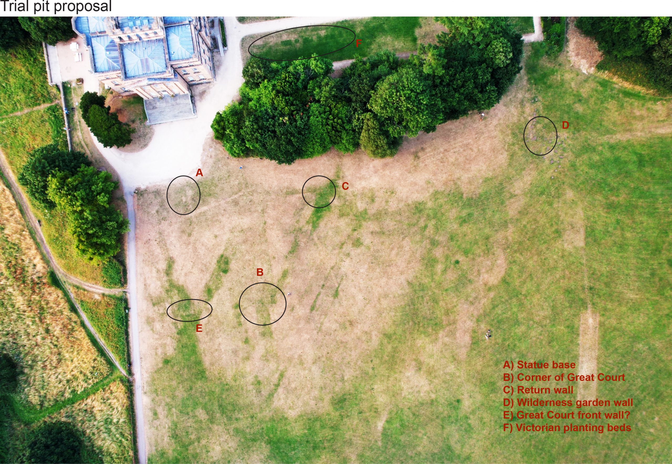
We reported last month on the parch parks that had become visible in the lawns around the house in the hot weather. We’re really grateful to Matt Ford, a drone enthusiast, who remembered us asking about this a couple of years ago, and captured a couple of great images looking down on the area. These have revealed much more about what we could see on the ground, and have also helped correct some of the archaeological survey work we’d undertaken in previous years.

An enhanced version of the drone photo, kindly provided by Matt Ford. The house is visible top-left. North is approximately in the same corner. 

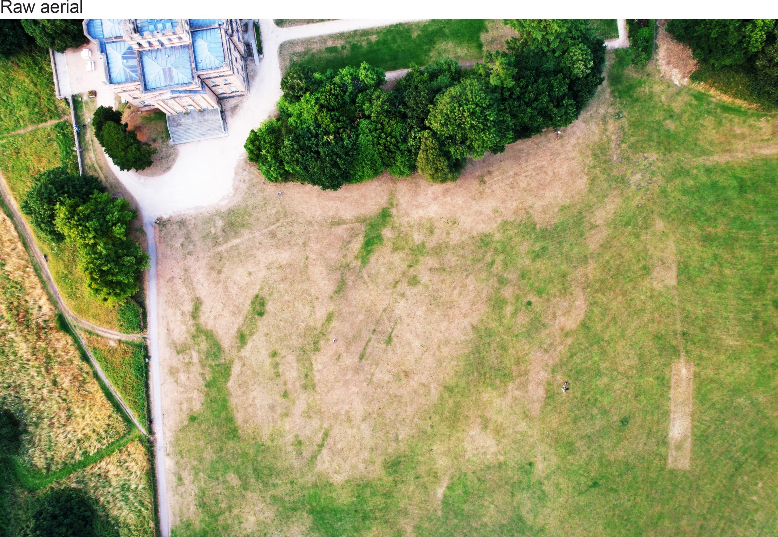
The first thing that probably stands out are the parallel green lines running diagonal to the house. These were also picked up with geophysics surveys and represent low-density, moisture-retaining features that have allowed the grass to remain green for longer. We now think the most likely explanation for these is that they are part of the underlying geology, running roughly aligned to Penpole ridge.  

 The irregular parallel features retaining moisture, and showing as green grass on the aerial photo. 
Enhanced photos showing the feint traces corresponding with the corner of the Great Court and the path aligned with the restored avenue. 

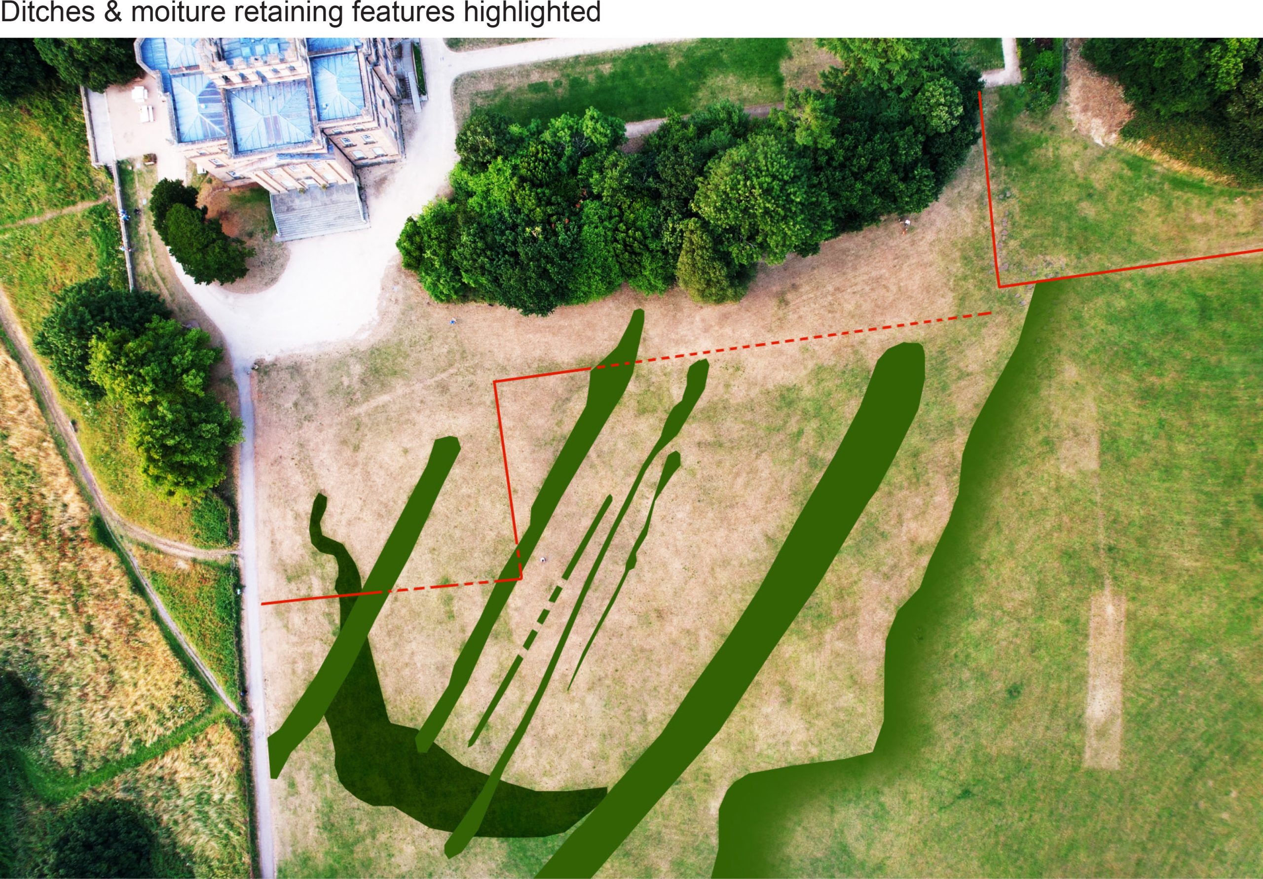
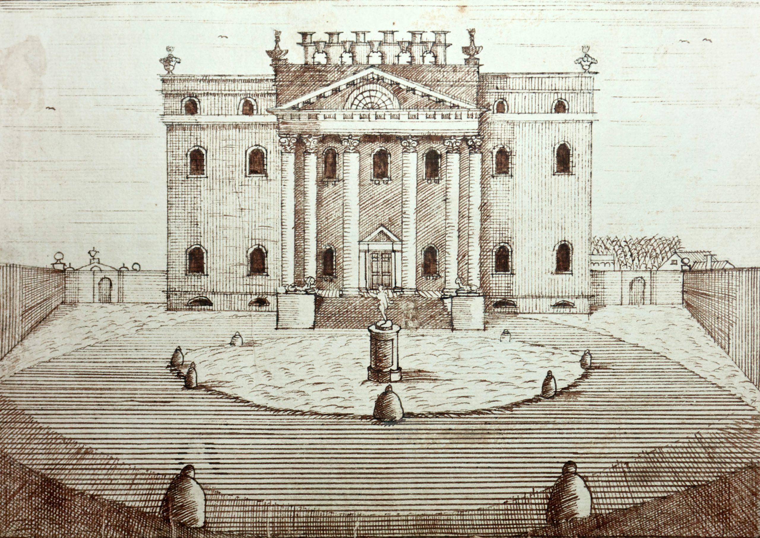
You have to look a little closer to start picking out some of the lost historic features. We knew the  outline of the Great Court in front of the main front of the house remained as a shadow in the geophysics data, but the hot weather revealed it physically on the ground once more. The court was created as the grand formal setting that helped frame the grand main facade of the house when it was rebuilt to the designs of Sir John Vanbrugh from 1712. The aerial photo includes a clear demarcation of the side and front walls, with a pronounced corner being the most defining feature (feature B). Also visible are wide strips of green heading away from the house and the Great Court. These are part of the parallel avenues of lime trees that once connected to The Circle as part of a grand axial arrangement, and alignment of out 2014 trees corresponding with that line.

Halett’s 172 map of the estate overlain, with features showing as parch marks identified. 
The Great Court illustrated in 1746 by James Stewart. the statue is visible in the centre of the walled area.
Diagram showing why the Great Court may be showing as a moisture-retaining greener area. 

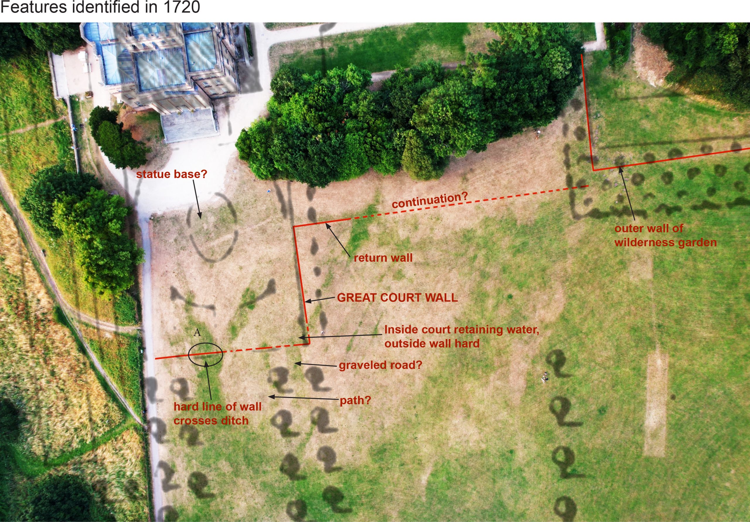
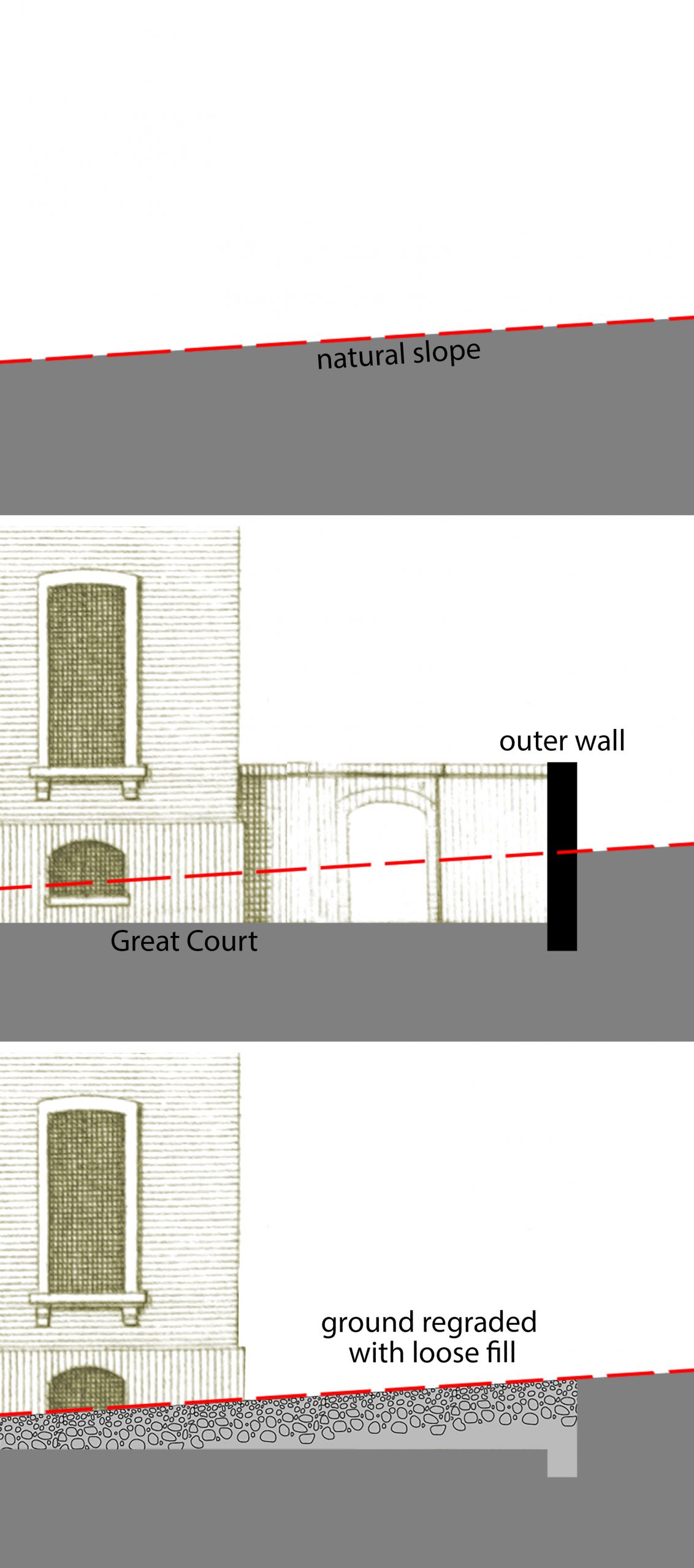
One thing that’s puzzling is why the Great Court shows as more green than the dry grass to the south. The visitor can still see the very shallow depression where the court must have been cut down directly into the rock to create a perfectly flat yard, so why would this not be harder ground with shallower soil that would dry out more quickly? It may be that, when the surrounding walls were taken down and the court deformalized in the 1760s, the ground had to be made back up again to form an unbroken smooth lawn. This would see looser fill material offering a better harbour for moisture, and explain why it read as low-density on the geophys. This also suggests the strips were also cut in, and later infilled.

The Great Court might explain another feature further to the north, a thin but defined line, that relates to the alignment of the front wall (Feature E). This was in the area covered by geophys, but there was no corresponding high-resistance feature that would otherwise indicate a wall. The jury’s out on this particular mark.

A pronounced feature (feature A) that does appear on the ground and the geophys is a hard lump or two nearly symmetrical with the front of the house. With its prominent location in the centre of the court it’s tempting to interpret this as being the foundation for the statue base for a statue of Hercules dating from the building of the house from 1712-1716; perhaps future excavation will reveal this and confirm whether the base of the statue of Hercules at Goldney House, Clifton, matches the one lost from Kings Weston.

Enhanced photos showing the corner of the Great Court showing up as a distinct green patch which continues towards the house.
 

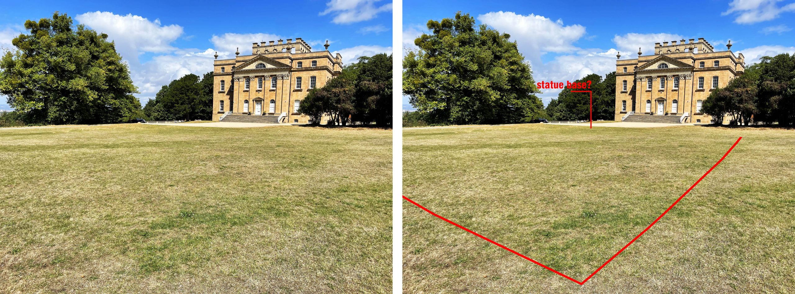
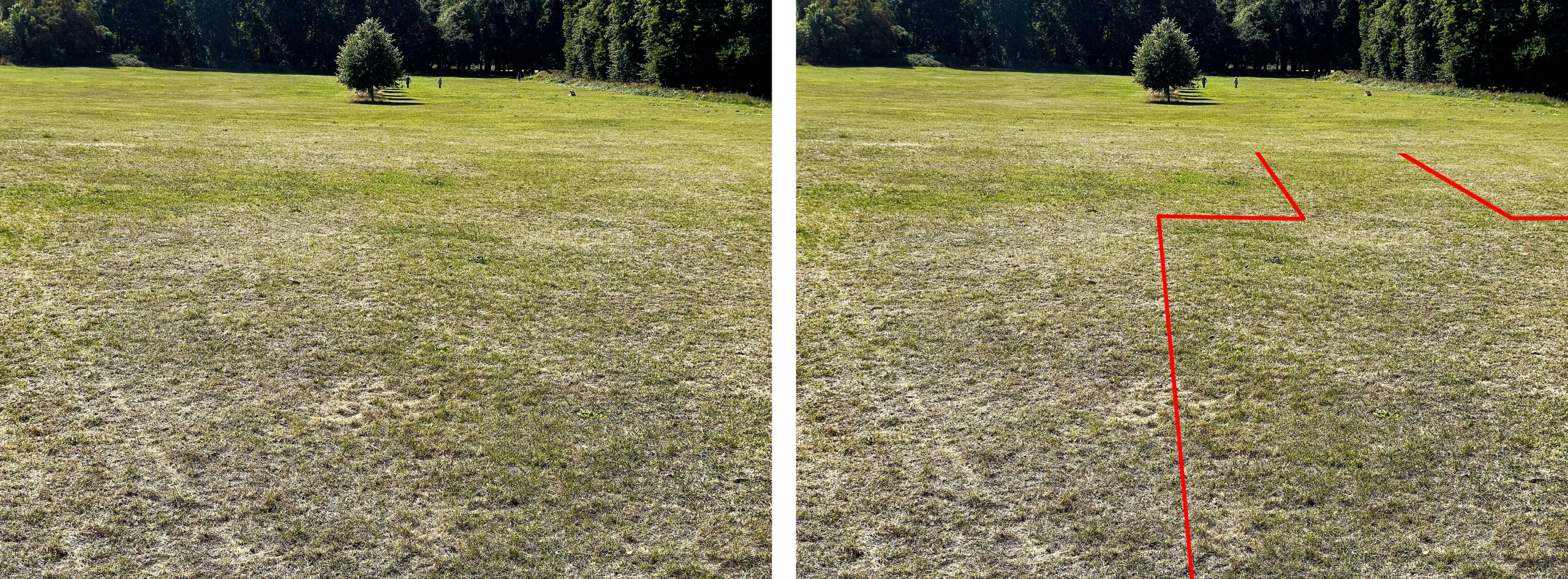
Our second geophys survey in 2017 we supposed to be geo-referenced to make sure it overlaid with our earlier 2014 results, however, the parch marks now indicate that it was a bit off. We have now been able to correct the overlap between the two by matching the physical marks on the ground. Comparing both parch parks and the survey shows that there is a return wall (feature C) stretching southwards, away from the Great Court that adds to our understanding of the garden layout. It’s not a feature shown on any early maps, but probably dates to the same period as the mansion. It bisects the Great Court midway along its south wall suggesting that it was aligned to the centre and the statue location.  

The archaeological geophysics results reconfigured over the parch parks, and showing correlating features.
Enhanced photo showing alignments of a linear feature and the outer wall of the wilderness garden.  

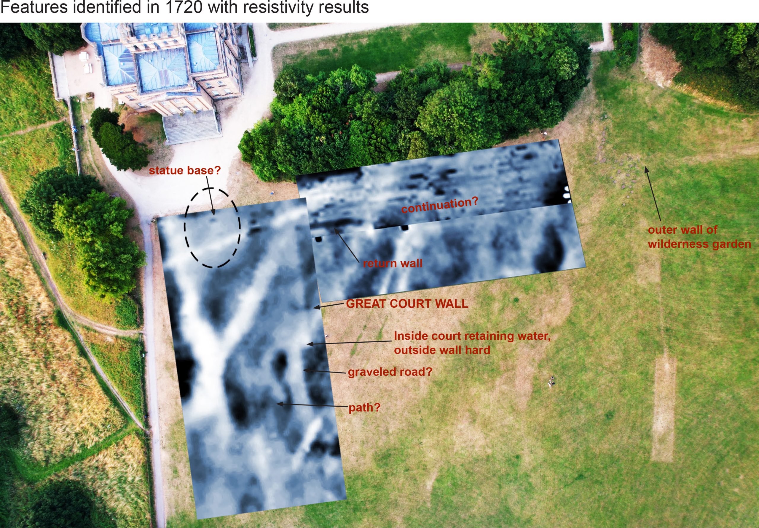
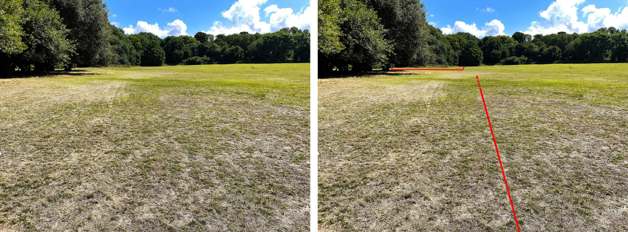
Another new discovery has been the locating of the garden wall of the second of the earlier large garden courts that spread out between the house and the Echo (feature D). We have this in early engravings and plans, but the parch marks now locate it physically. Marks show that the existing formal garden was designed to be slightly shorter, with the lost ‘wilderness’ garden beginning closer to the house than the current hedge. The marks also show that the wilderness garden was much wider than previously thought, and with this knowledge it’s now easy to see variations in the topography of the field that likely relate to it. This area may be worth looking at for archaeological excavation to explore what features might remain from this important 17th Century feature.

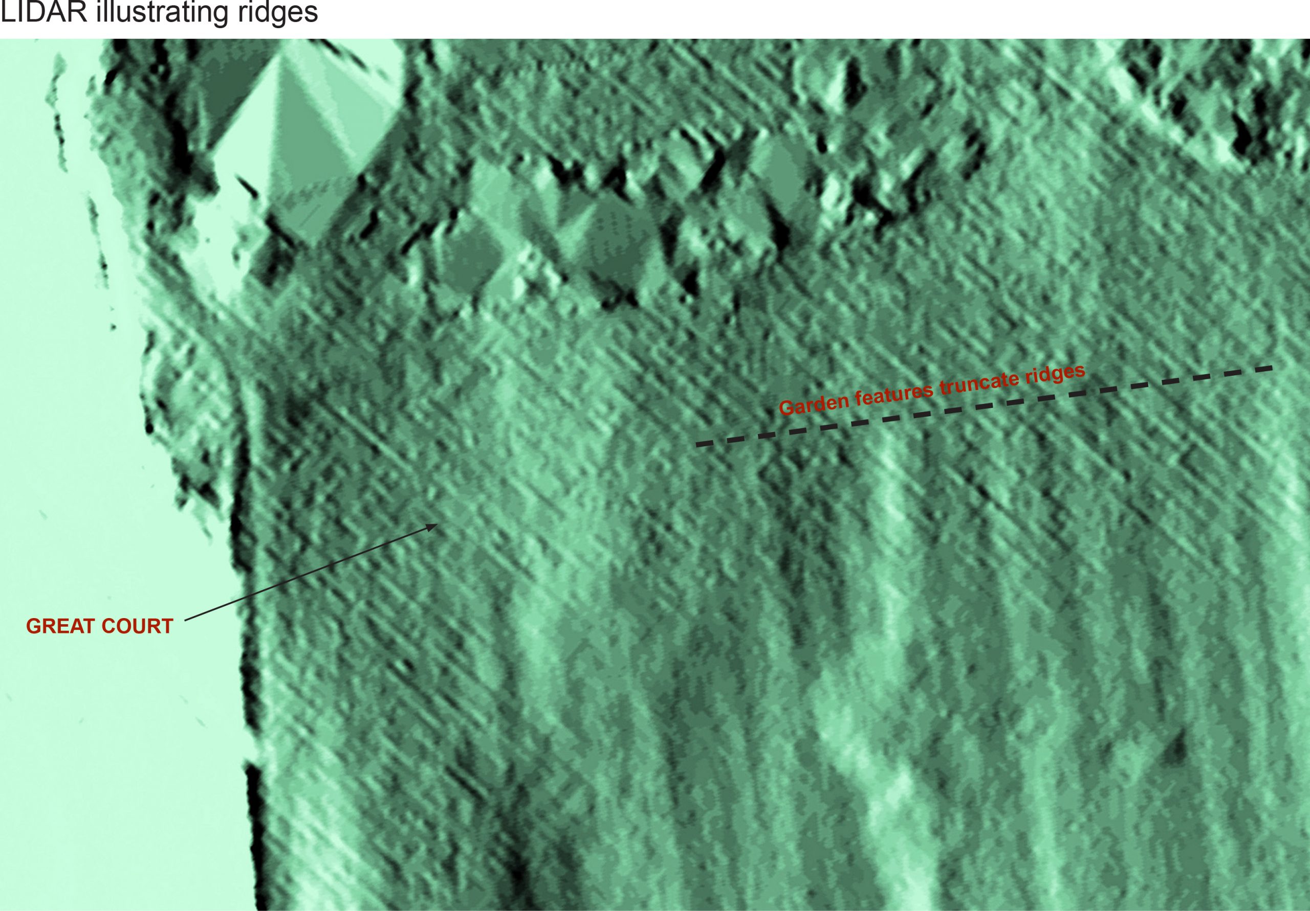
At this point it’s worth bringing in another survey technique: LiDAR (Light Detection and Ranging). This uses laser measuring to create a hyper-detailed topographical survey that can be adjusted to highlight lumps and bumps on the surface of the land. We know from this that there are a series of regular parallel ridges across the whole of the lawn, and that these don’t relate to the natural bedrock below. We don’t know what they are, or why they’re here, but we can tell is that they pre-date the 17th and 18th Century garden features as they’re truncated by them.

LiDAR survey showing how the earlier ridges were truncated by later garden features. 

One final detail brought out by the dry weather has at least photographic evidence supporting it; Moving attention to the garden front of the house there are marks in the recently laid lawn that correspond to alternating circular and rectangular rose and flower beds of the Victorian era (feature F). Perhaps a focus on this area in future years might reveal more of earlier garden layouts?

Key features identified on the enhanced aerial photo . 

Fascinating Fives Court

One building on the Kings Weston estate has had little attention focussed upon it over the years, but this article hopes to rectify that. Fives Court is now the home belonging to some of our volunteers who have kindly provided us with some photographs. It’s located on Kings Weston Lane, just at the junction of Napier Miles Road, and almost opposite the back entrance to the mansion. It presently sports a façade to the street inspired by the lodge opposite, but this obscures more work-a-day origins.

Fives Court from the junction with Napier Miles Road. Note the change in roof ridge-line.

Our first knowledge of it comes from one of two plans produced in 1772 by Isaac Taylor. The plans were drawn up after the laying out of a complex of walled gardens to the east and a long building matching the present Fives Court is included. It’s odd that it only appears on one of the two sheets covering this part of the estate and that it’s not shown coloured as the other buildings around it are, so perhaps this marks the construction date?

In 1772, a long building shown at right angles to Kings Weston Lane is likely to be the present Fives Court.

By 1849 it’s described as a Wood House, with a walled wood yard immediately to the south, and an open grass area occupying the corner of the road. It’s depicted as having a symmetrical plan with doors centrally positioned on the north and south sides, so very different from the rambling and picturesque outline of today’s house.

The building identified as a ‘wood house’ on a sketch survey of 1849. 


Its use as a woodshed seems to have been short-lived, and the modern name, Fives Court, is an insight to the building’s later Victorian History. Fives is a traditional game played like badminton, against a blank wall, but using the hand rather than a racket. It’s still a game associated with and played in public schools, with Clifton College still retaining a court in their Victorian buildings. The first mention of the building in use as a sports hall of sorts is in 1886 when one of the regular Shirehampton horticultural shows was held in the park and the following description was published in the Bristol Mercury:

“In the racquet court stalls were arranged and were laden with many beautiful objects of art, and at one end of the court was a collection of paintings, the work of the late Mrs R. Miles and Mr Frank Miles.”

Reconstruction of an 1840s Racquets court built at Eglinton Castle, Scotland. 

Indeed, by this point the shed appears to have been converted as a court for the game of racquets, similar but not identical for Fives. It may have been for the young Philip Napier Miles that the conversion was undertaken. Born in 1865, his time in public school may have seen him bring the sport home and the building refurbished to cater for a new passion. The original shed needed some work to accommodate the new use. Strictly speaking a Racquet court should be  30-by-60-foot, and the present building falls short of that a little. A more critical dimension was the playing wall, which also needed to be at least 30ft high. It appears that the original roof was too low to accommodate a court, and to get over this the east side was removed and reconstructed at a higher level, creating the pronounced step up in the roofline that remains obvious today. The twin doors would have had to be infilled to create a flush finish to the interior of the court, and new glazing was introduced into the raised gable end that now overlooked the walled garden.

The glazed gable end of the racquets court rising above the top of the walled garden, seen from the east. Circa 1898. 
 ‘Frank’ Miles, society portraitist and cousin of Philip Napier Miles of Kings Weston house. 

Diverging a little, one of the artists mentioned as exhibiting in the 1886 Horticultural show was a family member, Napier Miles’s cousin, Frank Miles. He was far from being a humble amateur, with a reputation as one of the leading society portraitists of his day. Between 1875 and 1881 he maintained a close relationship with Oscar Wilde, living together in a house in Tite Street in London, before Frank’s father threatened to cut his son off if he didn’t cut his ties with Wilde. The year of the racquet court exhibition was the same as his engagement to a miss Lucy Huges was announced, and he was at the height of his fame. How strange then that his works should appear in such modest circumstances at Kings Weston! Frank’s story took a dark turn the following year, with the engagement called off and his entry into the Brislington mental asylum after a breakdown. He died there four years later from “exhaustion and pneumonia”. Napier Miles did not attend the funeral, a private affair only for Franks three brothers. Frank must have visited Kings Weston, his father’s former family home, and it’s interesting to speculate whether Oscar Wilde ever accompanied him there.

The court continued to provide occasional use for fetes and bazaars held at the house into the 20th Century. In 1916 it was again the venue for artworks sold in aid of the Kingsweston Auxiliary Hospital as part of a grand Military Tournament held in the grounds. It may be that the building was converted for garage use for the Miles family at about this time with the addition of a big vehicle doorway directly onto Kings Weston Road, but documentary evidence is slim for this period.  

The racquets court in the 1980s, before residential conversion as the Fives Court. Courtesy of the Reid family

The racquet court was briefly requisitioned at the start of WWII, before being declared surplus and returned to the estate. It spent much of the war as the temporary home of some historic carriages that had been bombed out of their home in Bristol Museum. There are still locals to the area who remember seeing these through the doors of the building. One of the photographs shown to us by the Reid family shows the removal of some of these carriages in the 1980s, the building appearing in its earlier state before final conversion into a family home after 1985.  

 A dilapidated Victorian carriage is towed away from a shabby looking racquets court in the background. Circa 1980s.

Domestic interiors at Mr Southwell’s Kings Weston

We’ve often mentioned the incredible Kings Weston Book of Drawings (KWBoD), a unique collection of architectural drawings documenting the house and its construction and all dated to the first quarter of the 18th Century. The book is in the collections of the Bristol Archives and we’re reproduced drawings from it in many of our newsletters and on our website. One aspect we’ve never looked into is the internal decoration of the house as built. Many will know that the rooms of Kings Weston were all remodelled in the 1760s and later, and scant remains of the original character remain. However, inspecting the drawings gives us an insight into this lost world.

Undated draft of the chimney and mirror in the Kinsale Chamber (KWBoD)

The drawings also give us a puzzle. Whilst we can be certain about the layout and room names and uses after the 1760s, we are less certain over the earlier arrangement. There are rooms named, the Throwley Chamber, Kinsale Chamber, and Eating Parlour, that can’t be precisely located. We can assume that the Eating Parlour would have been on the principal ground floor, but wouldn’t have been in the same location as the later room that bore that name which was formed from the State Bedchamber. The description of several rooms as chambers implies they are, essentially, bedrooms, and most likely on the first floor.
 
Both Kinsale and Throwley chambers are named after the Southwell Family estates. Kinsale in southern Ireland was where the Southwell’s’ heralded from before Kings Weston, and Throwley Old Hall in Staffordshire came into the family through the marriage of Edward Southwell, rebuilder of the house, to Lady Elizabeth Cromwell. A further chamber is referred to in a letter from Edward Southwell in Dec 1713 when he writes ” I have almost forgot what I wrote about the two chimney pieces, but if I remember right I desired one according to the wooden model I sent, which being large was to go into the great parlour. The other I desired for a bedchamber of the common chamber size, and of the Italian moulding if you fit, to put it in the room I call Burton”; Burton was the estate of his cousin John Percival to whom the letter was written. The room names then follow a pattern of representing places of importance to the family.  

Cornice of the Throwley Chamber, dated Feb 1717

The drawing for the Throwley chamber illustrates a profile of a ceiling cornice. Comparing it with a similar example at Dyrham Park house, a building with close family bonds with kings Weston, we can assume this was intended to be of timberwork. The Kinsale Chamber drawing contains more of interest. It’s a design for a fire surround and chimney breast that would have been the focal point for this bed chamber. The fireplace is 5ft 2in wide and 4ft 1in high and probably wrought in polished stone or marble. Above it are mouldings, again of timber, framing a wide mirror with cushioned edges. By the level of detail it can be assumed that the mirror was already in existence and the designs were drawn with the intention of incorporating it into the new room. Above the mirror were further cornice mouldings and panel work taking things as far as the ceiling. Again, the arrangement isn’t dissimilar from some of the interiors at Dyrham.

One of the anterooms to first floor apartments at Dyrham Park house give a good impression of how Kings Weston’s rooms may have looked. 

Two drawings can be more firmly located within the house; these are fireplaces for Mr Southwell’s closet and chamber. Aside from the State Bedchamber on the ground floor this would have been the finest furnished rooms. The principal chamber in later eras was in the southern corner of the house, with an outlook over the garden to the Echo. Reviewing the plan of the house published shortly after completion this is most likely to have been intended as Southwell’s bed chamber and private rooms.
 
The first floor of the house was laid out as a series of apartments which could be allocated to family members or used by guests. There are three apartments on the first floor connected by common anterooms. In the later 18th Century the central anteroom overlooking the Echo Walk was called the Tapestry Room, and it’s possible this interior, with its old fashioned wall hangings, survived the 1760s refurbishments.  A smaller bed chamber occupied the western corner of the house directly off the servants stair, but separate and not identifiable as a part of a suite of rooms; Aside from Mr Southwell’s chamber this is the only room shown where there is a pronounced chimney breast, so might be tentatively identified as the Kinsale chamber. The other two bedchambers on this floor had fireplaces flush with the interior wall.

The first floor layout of apartments at Kings Weston when first complete, with the KWBoD drawings located. 

Each apartment consisted of a bedchamber, and two further rooms. The principal of these smaller rooms was equipped with a fireplace, whilst the lesser room was unheated; this was possibly a dressing room. The design for Mr Southwell’s closet is the most decorative of the interior drawings, and this illustrates the status the room enjoyed. The panelling here doesn’t reach the whole height of the room, instead a more intimate character is created by a lower cornice level. The fireplace is shown with ornate decoration, probably carved in wood. The drawing suggests that this incorporates wreathes of foliage framing a central panel, possibly a painting, and a crowning section of more indistinguishable decoration. Either side of this centrepiece candle sconces are fixed. The wall space above the ornamental panelling is reserved for a painting.  

Undated drawing of Mr Southwell’s closet fireplace (KWBoD)


The function of the closet was to offer a private retreat for the apartment’s occupant; somewhere they could display their most important treasures and intimate effects. It was a room for display, but only to the most limited of audiences. A good example of this sort of room exists in the Cedar Closet at Tredegar house, Newport, though from about a generation earlier that Edward Southwell’s new house.
 
The Closet drawing has curious pricked lines on one side of the chimney breast which are not easily explained. They may be an alternative decorative scheme with carved stacked quoins mimicking an architectural detail in stone, or they could intimate shelving concealed behind the panelling.

The Cedar Closet, Tredegar House, Newport dates to around 1670, but gives an impression of the scale and appearance of Mr Southwell’s closet room

Mr Southwell’s Chamber also has its chimneypiece drawn. This Is a fairly straightforward design with timber panelling up the chimney breast and terminating against the ceiling with a boldly projecting cornice. The focus of this feature was likely to be a painting hung over the narrow mantelpiece. Between this and the stone fire surround there’s a wide panel picked out in grey ink, and with four quite substantial fixings; was this for another painting, or could it have been for a carved stone plaque? The vast scale of the proposed chimney breast is only revealed when a figure is added to the same scale, as we’ve illustrated here.  

Chimney intended for Mr Southwell’s Chamber with figure added for scale.

 The last drawing, or drawings, we’ll look at here are of another fire surround, to be “wrought out of the ash colour marble”. A surround in similar grey marble still exists on the second floor. The two drawings clearly show the same fire surround and one is dated 13th Feb 1718. This shows us that, although Southwell moved in with his new wife in 1716, that there were still significant fitting out works being undertaken on rooms. The same dated drawing describes the drawing as a “coppy of Mrs le Grand’s draught of a chimney piece”.
 
Mrs Helena Le Grand was Edward Southwell’s older sister. He had delegated the setting up of the house to her before he moved in when she was “fully employed in transposing and setting the furniture, pictures and cheney”. The second drawing showing the fireplace may then be her own drawing from which a  second version was taken and annotated. Was she more involved in the design of the house, or its interiors than we’ve previously been aware?

The two drawings for a chimneypiece of ash colored marble, the original on the left with the copy on the right dated Feb 1718. 

One thing that this short series of drawings show is that the first floor interiors were very traditional, not having the same architectural drama of Sir John Vanbrugh’s exteriors, Saloon or stair hall. The layout and appearance would not have been unusual in a house from thirty years previous like Tredegar. It’s unlikely we’ll ever know how the State rooms on the ground floor were decorated, but the first floor chambers were not ostentatious and would have relied largely on their furnishings for any display of wealth or status.

New acquisition

A historic document has just come our way related to Kings Weston. It is a contract between Edward Southwell II of Kings Weston, his Court acquaintance James Vernon, and John Lambert, a builder of Lambeth to complete a building at Spring Gardens In London. Spring Gardens was the London home of the Southwell Family and they sought to develop the land they leased from the Crown from the 1730s onwards. This document from 1754 is an interesting insight into Edward Southwell’s development of the site around his Spring Garden Mansion.

Spring Gardens was located on the south side of Trafalgar Square, where The Mall now joins it. It disappeared under the construction of Admiralty Arch at the start of the Twentieth Century, but you can see where it was on this map. The area shown here was the house and garden of the Southwell’s in 1777 after they had leased much of their surrounding property for development.

The document is particularly interesting for its three wax seals, all bearing the arms of Edward Southwell II surmounted with the armorial goat. Edward’s signature bestrides the best of these seals.

spring gardens