October’s Big Bulb Plant at the Iron Bridge has come good with a sensational display this Spring. The heavy work preparing the ground and digging holes through rubble was definitely worth the effort; the visual impact speaks for itself!
A panorama looking down and across the slope towards Shirehampton Road with the bridge on the left. The City boundary marker is now surrounded by flowers.
Both sides of the Iron Bridge looked phenomenal in the Spring sun during March, though flowers are just going over now. We hope that everyone who contributed to the bulb plant will have had the chance to go up, take a look and enjoy the display. It certainly seems to have attracted a lot of attention.
John Loudon McAdam’s iron bridge is now set in a sea of gold on the Kingsweston Hill side
This October we hope to give daffodils a rest. The cultivated blooms are not suitable for many parts of the historic estate and we’re keen to diversify into more native species. As part of the Nature Conservation plan being developed by the Council we hope to agree suitable species and locations that will both ornament the estate and improve its appeal for nature.
The northern approach to the bridge on the Kingsweston Hill side.
In error, we ordered far more daffodil bulbs than we anticipated ahead of our annual Big Bulb Plant in October. Instead of 7000, volunteers who came along had the challenge of getting 9000 bulbs into the ground. Matters were exasperated too, by the quality of the ground around the historic Kings Weston iron bridge where we’d committed to plant. Earlier this year, with the support of the Save the Green Iron Bridge group and Janet Poole., donations were collected as part of the celebrations around the reopening of the bridge, and it seemed fit to decorate either side of the structure with these flowers. When it came to it, this was easier said than done.
Work begins on the east side of the bridge with plenty of family involvement.
The event began at 10am and gradually volunteer numbers grew throughout the morning. Those tasked with digging holes for the bulbs immediately found the ground to be poor, filled, as it was, with rubble sat there from decades before. Both sides of the bridge were heavy going, large lumps of building stone, brick, tarmac and all manner of material dumped there for inexplicable reasons and buried beneath the turf. This considerably slowed progress throughout the day, particularly on the west side. We still don’t know where all this material came from, but it could have been demolition rubble from the WWII use of the estate or some well-meaning council plan to level the ground around the bridge.
By lunchtime, opportunities to plant on the eastern side were exhausted, and everyone moved over to support the beleaguered team on the west. Aside from the challenge of the ground conditions, the day was perfect for the task, breaking out in sunshine by the end of the day, helpfully illuminating the slopes of Shirehampton Park as it sank towards the horizon. Fine tilth of soil left by digging bramble roots out sped progress as the afternoon progressed, and work was completed with the trimming of some self-seeded saplings that might overshadow the newly planted area.
A big gang of volunteers moves gradually along the grass from the bridge. The western side of the iron bridge proved the biggest challenge to dig.
We’re immensely grateful for everyone who came along throughout the day, no matter how long they were able to help for. We hope that the daffodils will now find their own path and root well in the troublesome ground before next spring and give us a fine display. Whilst we didn’t manage to get the full compliment in the ground, 6500 bulbs made it in. The surplus will form the basis of this month’s working party and go in along Shirehampton Road.
Last month we reported on the ‘official’ opening of the Kings Weston Iron Bridge, but on Sunday 14th July the community celebration very much in the earlier event to shade! The event enjoyed a lovely sunny afternoon and attracted around 200 guests who were serenaded by the Bristol Ukulele Band as they gathered at the Kings Weston end of the bridge. Proceedings began with the 126th Scouts (Sea Mills) parading over the newly open bridge with their troop banners arriving in the informal arena at the west side.
Janet Poole receives flowers in thanks on behalf of KWAG. (Bob Pitchford)
Sea Mills Scouts parade their banners over the bridge.
Janet Poole, who has been so instrumental in promoting and championing the repair of the bridge took a stand on the newly finished steps and addressed the crowd. She undertook to thank everyone involved with the project including the construction workers and support from KWAG during the lengthy process getting it reinstated. In gratitude for her tireless work, KWAG’s chair presented a bouquet of flowers on behalf of everyone who’d missed the bridge over the last nine years. Finally a ribbon was strung between the railings and ceremonially cut to re-inaugurate the historic structure.
A collection held during the event raised £121 towards KWAG’s Big Bulb Plant this October, for planting of daffodils either side of the bridge. The bridge was in very active use during event, with many guests taking their first opportunity to cross the bridge in its new raised location. Louis, a twelve year old drummer, closed proceedings with a rousing session in the sun. At the generous invitation of John Barbey of Kings Weston house, many people sauntered back to the vaulted coffee shop where complementary drinks and cake rounded off a beautiful and memorable celebration, a fit conclusion to a long-running saga.
Finally!! A major milestone in the iron bridge restoration was reached at the end of last month, with the return of the historic structure, albeit 1.1 metres higher. Contractors started work early in the morning of the 30th May, bringing in a crane, the bridge strapped to a flat-loader, and closing the footpaths nearby for safety. A group of campaigners and visitors gathered at the west abutment to watch proceedings.
With spectators beyond, contractors watch as the first half of the freshly restored and painted bridge is craned back into place.
The east half of the bridge returns to meet its partner half way.
The bridge looks resplendent in its new livery of dark green paint, a colour picked to match the original colouring found beneath old paint layers. Contractors from Dorothea Restoration and Griffiths were on hand to make sure that the components would fit back together in their new position; not an easy task with the bearing stones having to be raised and reset at their new level.
The first section, the west end, was gradually lowered into place, and proved the more troublesome of the parts. After a bit of to-ing and fro-ing and cutting of the stonework it was eventually seated in position. The east end then followed, then the central plate that fastened the two ends of the bridge together. After some careful adjustment the whole structure was back in place and true.
Work will carry on now, touching up the new paintwork, erecting the steps either end, and fitting the handrails and railings to them. The road closure has been extended until the 15th to allow some of this work to be done, and the final completion is supposed to be the first week in July. Everyone is looking forward to being able to celebrate the reopening!
T he two halves back in place, awaiting the central joining connection.
Two of the 1904 boundary stones returned to their original locations on the west abutment of the bridge.
Something we’ve been eager to protect as part of the iron bridge works are the set of three stone markers that formerly nestled beneath undergrowth on the west abutment. Each stone is carved with the date, 1904, and CB, for City of Bristol. These marked the city boundaries between that date and 1935.
After the opening of Avonmouth Dock in 1877, the gradual development of the village of Avonmouth, and the purchase of the Docks by the Corporation in 1884, there was political impetus to bring the area within the city’s administrative boundary. The city had expanded quickly in the late 19th Century, but growth northwards from the historic boundary along the Downs was limited. Despite a strong argument for bringing everything between there and Avonmouth into the city it was only the Docks themselves that were eventually added in 1897. This left them as an isolated satellite part of the city, disconnected from the main administrative boundary.
Philip Napier Miles of Kings Weston was eager to develop his landholding around Avonmouth and Shirehampton. A plan for “Avonmouth as a city” was well advanced by 1902, with ambitious plans for thousands of acres of land laid out. It was perhaps this prospect that reinvigorated the arguments to bring more of the area within Bristol’s boundary; The 1904 Corporation Act was the mechanism to achieve this.
The city boundary shown shaded on the 1916 Ordnance Survey map, and with boundary markers marked as orange dots. Most of these remain today.
The Act did not go unchallenged, however. There was considerable opposition by residents in Stoke Bishop and Westbury on Trym who did not want to leave Gloucestershire and contribute the more onerous rates of Bristol. Amongst these objectors was Napier Miles himself; his concerns were that Kings Weston house would fall within the new boundary and that his landholding it would be reduced, in value and freedoms to develop it hindered. In the event, the Council changed the proposals to omit Kings Weston’s Home Park, instead taking a line from the iron bridge to The Circle, skirting the Georgian viewing terrace , before following the historic parish boundary through Penpole Wood. This satisfied the Council who’s intention to physically connect Avonmouth and Shirehampton with the rest of the city required only Shirehampton Park to be included. Napier Miles also secured a series of provisions from the Council that satisfied his concerns, and in August 1904 the Act received Royal assent.
The third marker on the corner north of the other two at the west abutment.
It can’t have been long before the city marked its new perimeter with permanent stone markers of the sort found at the iron bridge. Although they project just a couple of feet above ground, they are hefty stones, designed not to be easily moved or damaged, are about 5 feet in height. Another of these stones was spotted in 2016 when we came across it near the white oak. What’s less clear is why the boundary didn’t include Park Lodge and run up the west edge of Kings Weston Road rather than making an odd dog-leg to take it up to the bridge, resulting in the three markers we have today.
As part of the bridge works the contractors have carefully excavated the stones, kept them safe, and have now reinstalled them in their original locations. Whilst they are now little more than relics, their preservation allows new light to be shed on their historic interest.
It is almost a year since the historic Iron Bridge across Kings Weston Road was hit by a lorry and damaged an severed an important footpath. At last we have some good news to report: Bristol City Council highways team have now started commissioning survey work of the Grade II Listed structure in advance of physical work being undertaken to reopen it.
A structural survey is just one element of the package of information needed to ensure the most sensitive approach is taken in making repairs; A Listed building assessment and heritage report is also being undertaken by the city’s conservation team to ensure that the significance of the structure is understood, and to inform best practice in dismantling and reinstating damaged elements.
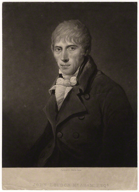
John Loudon McAdam (1756-1836)
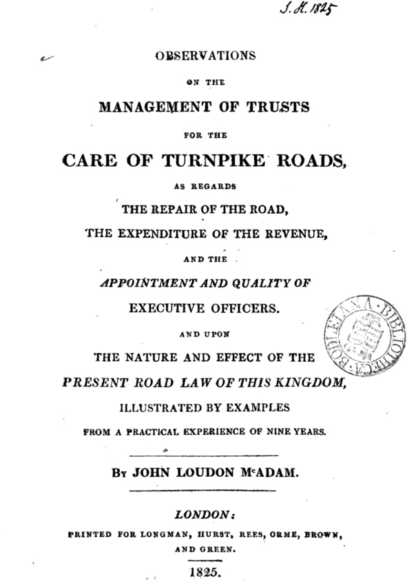
The bridge was designed by the eminent highways engineer John Louden McAdam who, at the time, was the engineer tasked with improving the turnpike roads around Bristol. In 1819 the lane, a parish road between Kings Weston and Henbury, was turned into a turnpike road and work commenced to improve standards to justify the tolls levied on such routes.
It wasn’t until 1821 that McAdam noted in his observations that labourers had begun lowering the hill and building walls at Kingsweston Hill. This would have formed the deep cutting through which the current road passes. In the following year he notes the formation of a new footpath in association with the same works which is likely to have been the track approaching the old inn from the Sea Mills direction. It’s probable that the iron bridge was installed at the same time, as the completion of these ambitious works.
Title page of McAdam’s 1825 Observations
The bridge was constructed of more than 130 individual components of both cast and wrought iron. More technically advanced than most similar structures of the period it used a closed-mould casting technique which allowed the incorporation of strengthening flanges to the structure. New work has been undertaken by KWAG, in cooperation with the Council’s conservation team, that sheds light on the construction and fabrication of the bridge. Following a study of the structure a 3D model has been created which will now be used to inform the best approach to restoration. As you can see, for such a small structure, it’s surprisingly complex!
The city’s highways officers are currently considering options to raise the bridge to remove the possibility of it being hit again in the future. There is also the potential that the whole of the bridge will need to be dismantled and removed before re-installation. As the project develops we hope to be able to report on progress, but physical work is unlikely to begin before spring 2017.
exploded diagram undertaken by KWAG showing the construction of the Iron Bridge


