An old master oil painting, once the collections of the Southwell family of Kings Weston house, has recently been advertised for auction. We note, with disappointment, that it has recently been released from the large collection of historic Kings Weston paintings held in trust by the descendants of the Southwell’s, later Barons de Clifford.
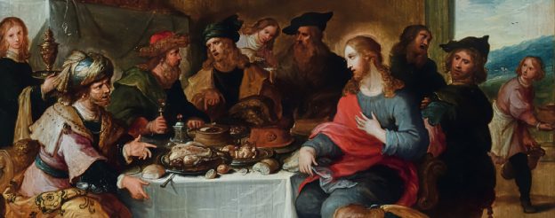
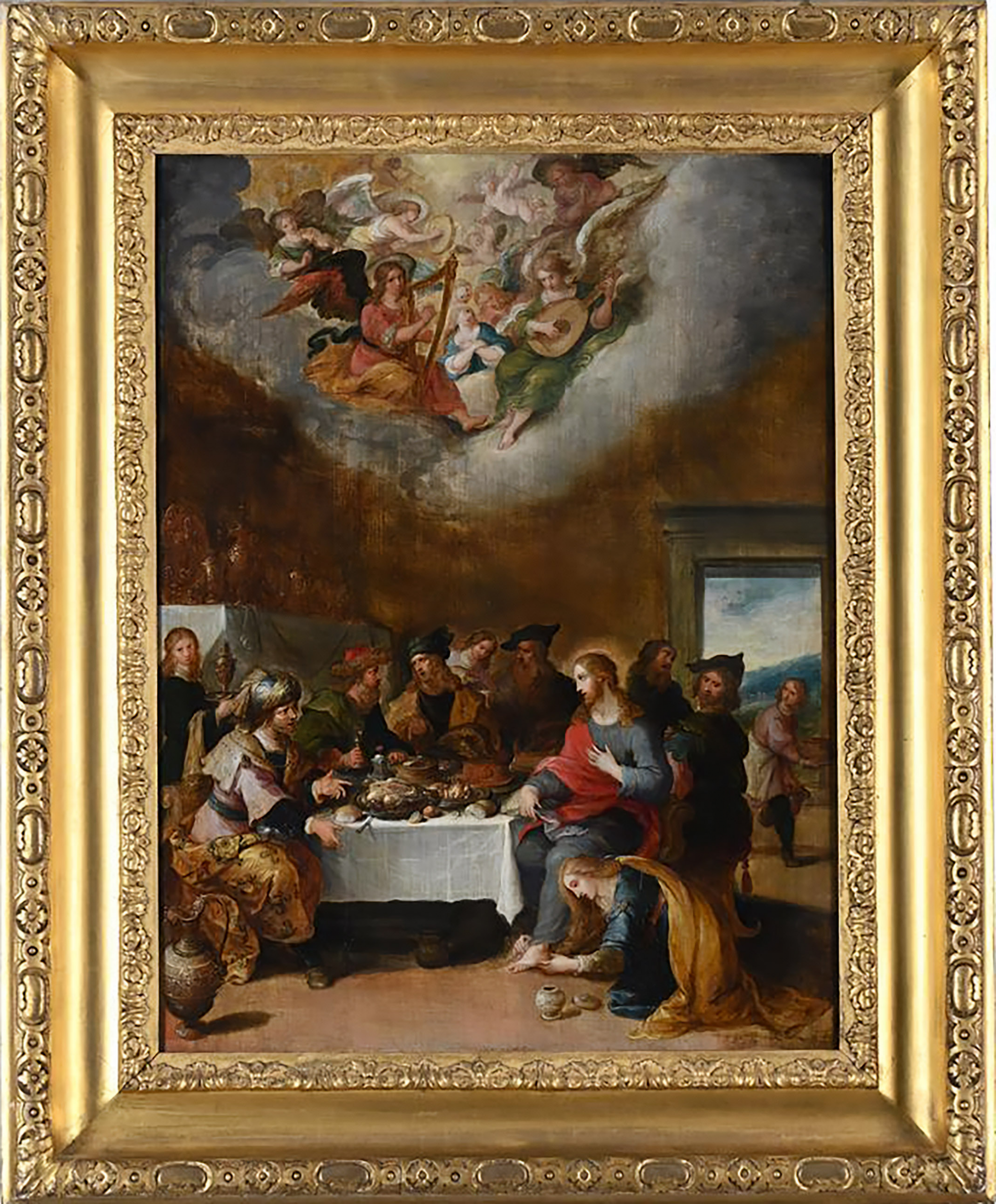
Christ in the House of Simon the Pharisee, one of the Old Master paintings once given pride of place in Lady de Clifford’s private chambers.
Formerly Lady de Clifford’s Dressing Room, this “long and lofty” space once had “no equal in the Kingdom” and was hung with paintings “the subjects in general are small, but they are of the first excellence” . Seen during work in 2014.
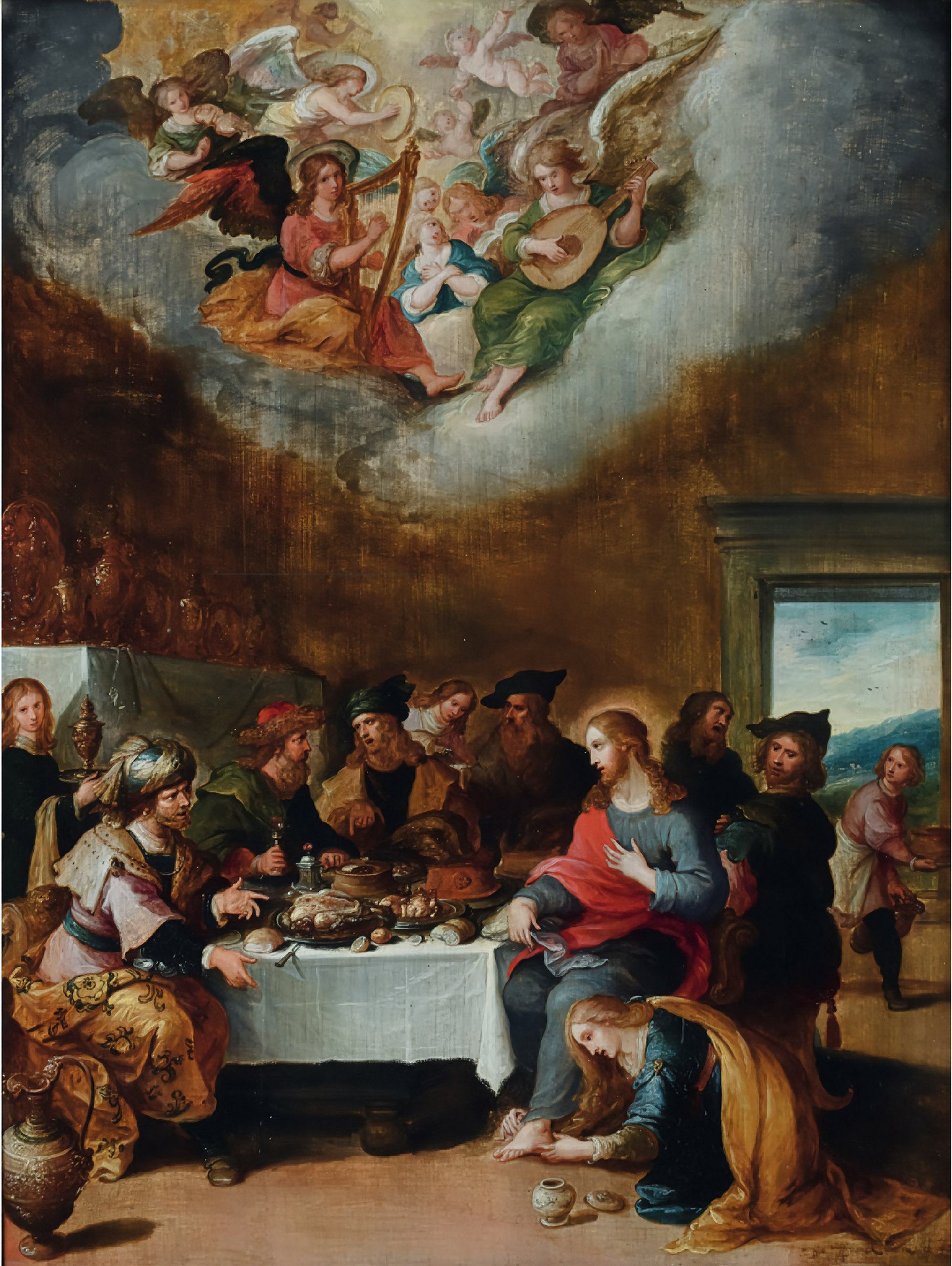
The painting, Christ in the House of Simon the Pharisee, is first recorded hanging in Lady de Clifford’s dressing room decorated in blue silk damask. This room is now the first floor room with the bay window overlooking the Severn. Here it accompanied some of the best of the family’s collection of paintings, the most intimate, and intended only for view by them or their most special guests. On the surrounding walls were works by Claude Lorrain, Nicolas Poussin, Annibale Carracci, Pietro da Cortona, and four paintings by Canaletto.
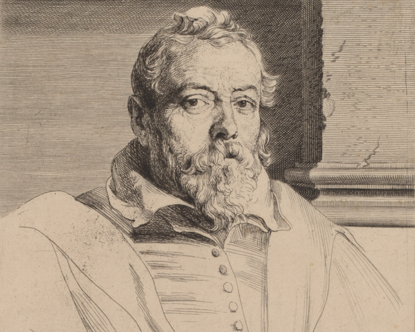
An inventory of the contents of the house in 1777 describes the painting as “The washing of our saviour’s feet” and the artist as “Old Frank”. This attribution has now been revised and is now considered to be by his son, Frans Francken the younger (1581-1642). The 18th-century attribution to Francken the Elder likely stems from the signature “D.o. ffranck,” where “D.o.” stands for the Flemish de oude, meaning “the Elder.” However, this signature was actually used by Frans Francken the Younger from the late 1620s. Prior to the death of his father in 1616, he had signed his works as “the young Frans Francken.”
Engraving of the artist Frans Francken the Younger ( 1581-1642) by Van Dyke.
Whilst the auctioneer suggests that it come to Kings Weston courtesy of the second Edward Southwell (1705-1755), it’s more likely to have been during one of Sir Robert Southwell’s journeys across the Low Countries that it was purchased or perhaps his son, Edward’s travels in 1697; it’s not included in an inventory of pictures at Kings Weston from 1695, so perhaps the latter is more probable.
The framed painting shortly to be sold
The painting remained at Kings Weston until the last of the direct line of the Southwell Family, The 21st Baron de Clifford, died in 1832. With no direct heir, he willed that the contents of the house be sold in its entirety. The painting, by this time described as Mary Magdalen washing the feet of Christ and attributed to Old Franks, sold for £10 10 shillings, as much as a painting by the more famous Poussin. As was common, it’s likely that a family member bought back a number of paintings, perhaps one of the nieces who were the ultimate beneficiaries of the sale.
We last saw the painting just outside Taunton where the family trust stored much of the collection of paintings. The circumstances and reason for it leaving such an important private collection are unknown, but we’ll endeavour to find out. If anyone were interested in returning it to Kings Weston, it will be sold via Dreweatts auction house on November 4th and the current estimate is £20-30,000!
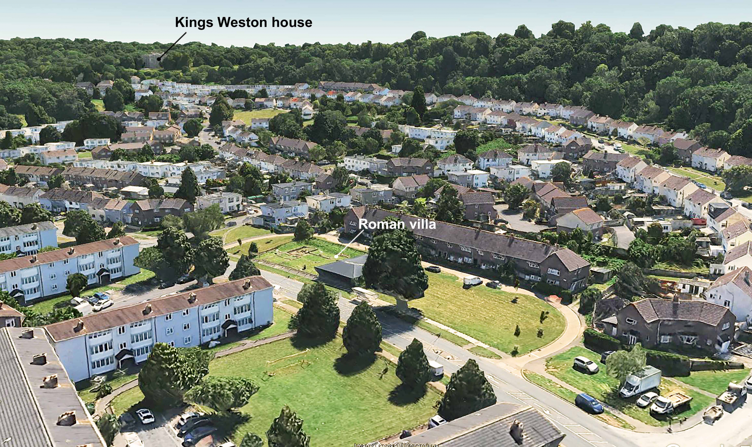
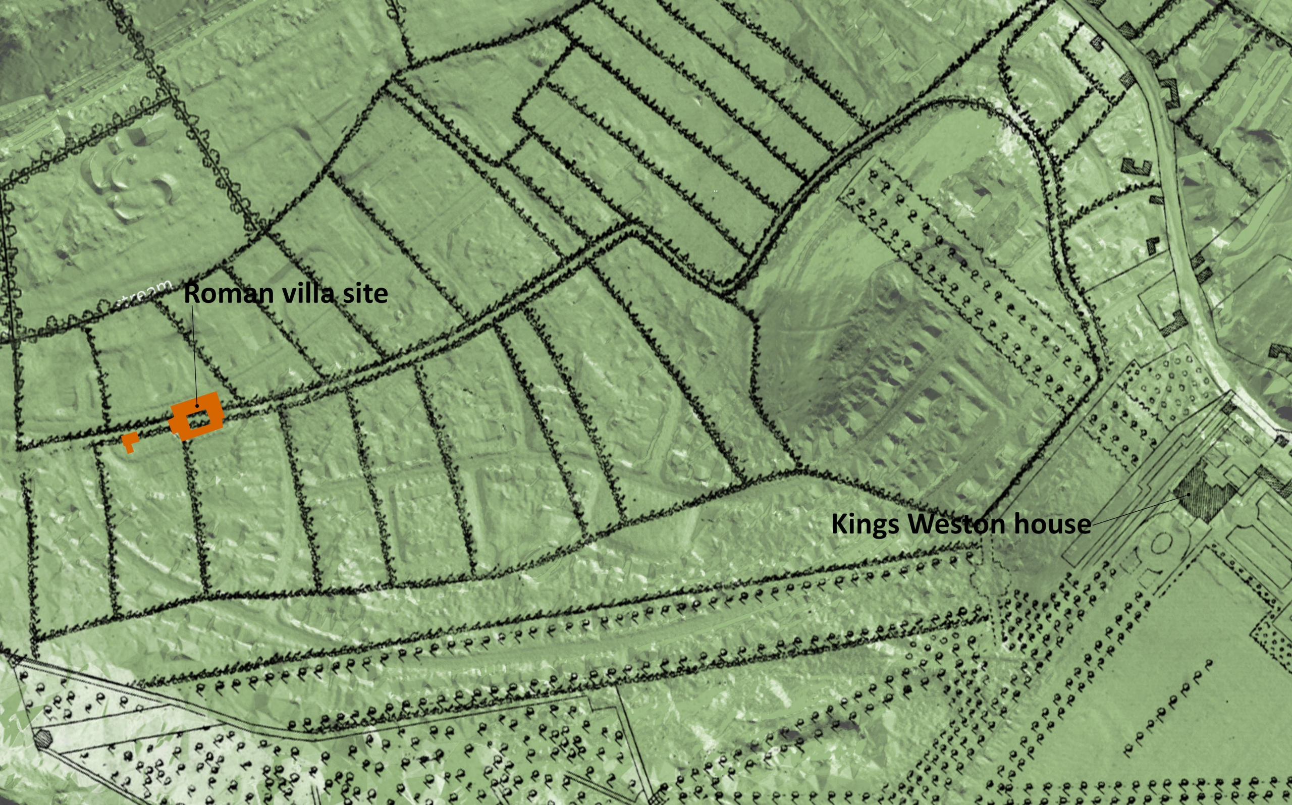
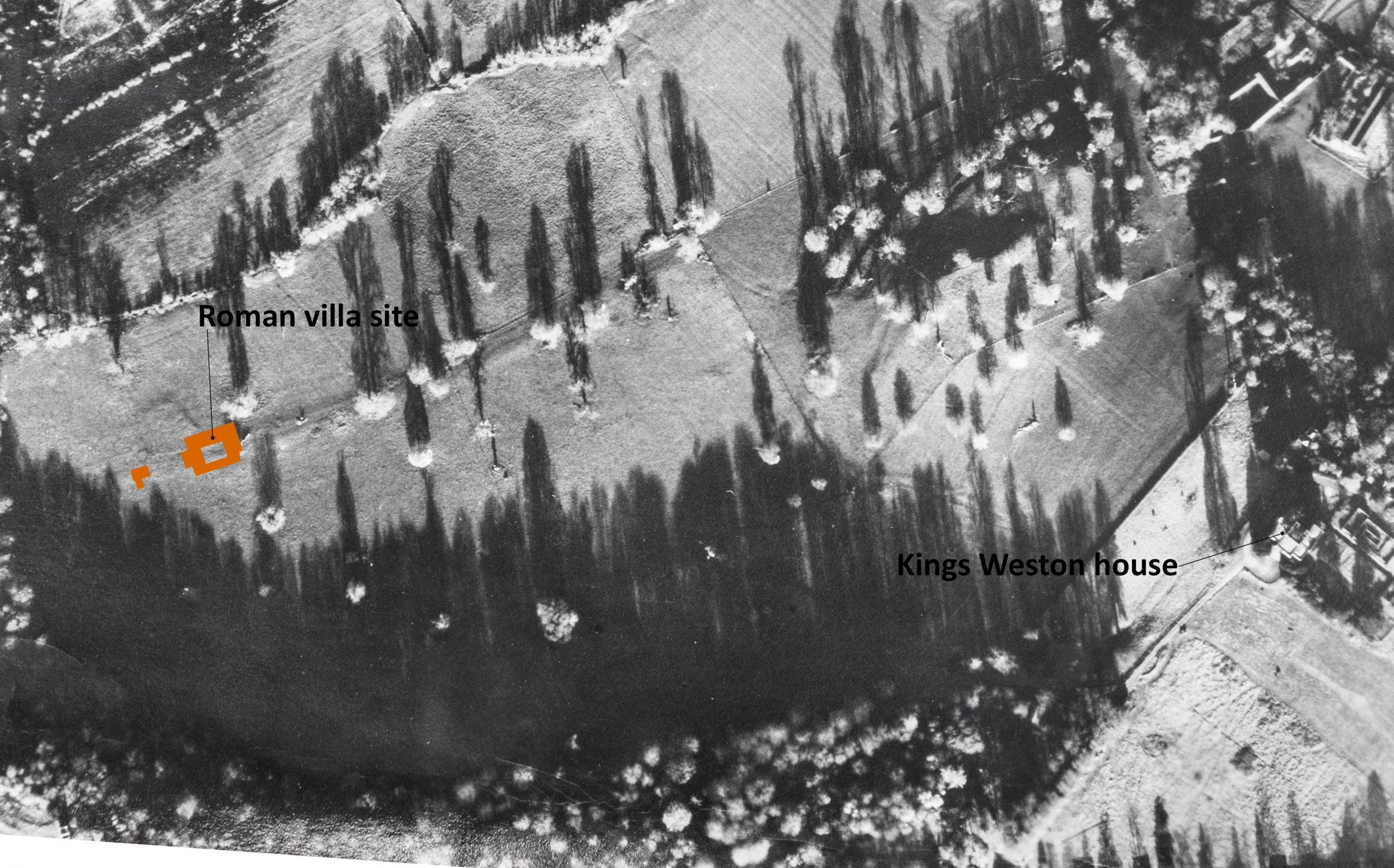
There’s been some exciting developments at the Kings Weston Roman Villa. The ancient ruins lay undisturbed beneath the grounds of Kings Weston house, unknown to its owners for more than 1,500 years, until Lawrence Weston estate was laid out over the northern part of the landscape parkland in the late 1940s. The remains were badly damaged before their significance was realised in 1947. Several seasons of archaeological work between 1948 and 1950 revealed the extent of the main villa building including decorative mosaic pavements and a bath complex. The remains were consolidated and the site made a branch museum of the city’s Museum and Art Gallery. Whilst there’s been regular new work on understanding and interpreting the site and its finds since the 1950s, there’s been little archaeological work done on the site…. Until now!
Aerial view showing the Roman Villa in relation to Kings Weston house.
Some of our Bristol members might have seen an awful accident in October last year reported in the press, when a car came off the road and crashed into the site. Fortunately, the vehicle made little impact on the roman remains themselves, hitting the surrounding fence and timber museum building only. The need to put this damage right, a small grant, and the desire to make the site more accessible has enabled the museum and archaeologists to commission new survey work.
Much modern archaeology depends on non-invasive techniques rather than the traditional digging of trenches. Ground Penetrating Radar is now regularly used to explore below ground; we’ve even had areas around Kings Weston house surveyed before now. It was this type of survey that was recently undertaken by Wessex Archaeology on the open grass areas immediately surrounding the museum’s boundary fence and the results have been remarkable. The full report can be read here.
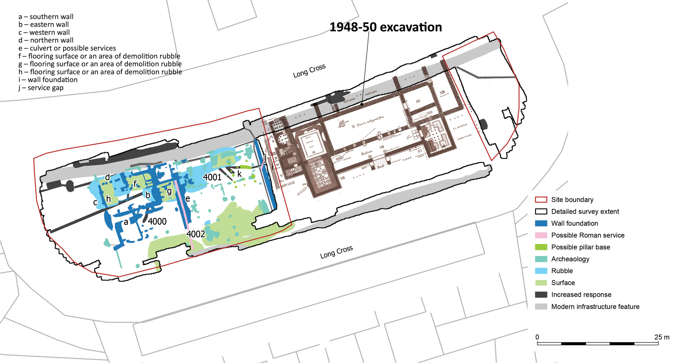
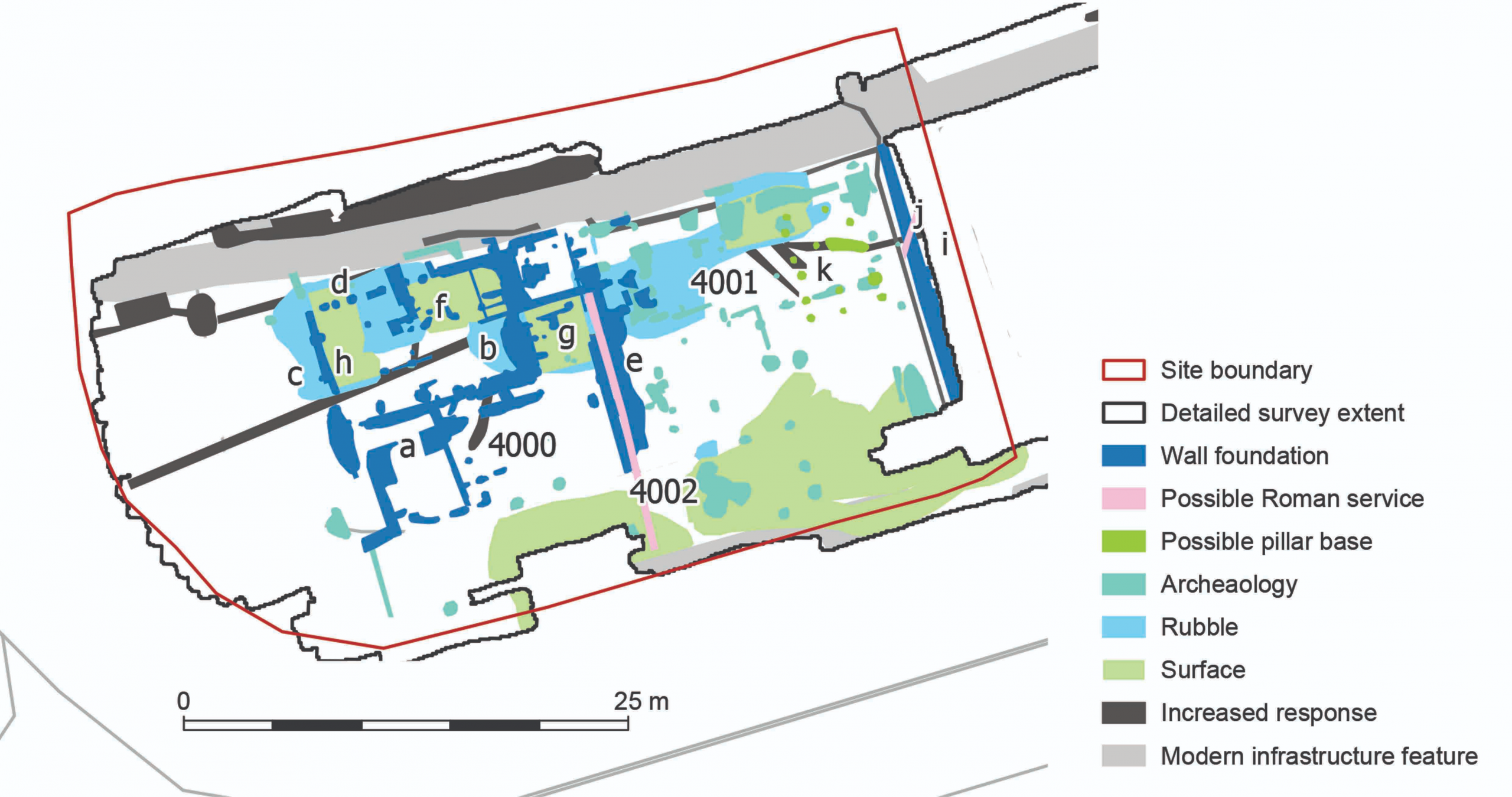
The new GPR survey in relation to the villa excavated 1948-50
Despite a lot of interference due to modern features like the pavements, the geophys results have identified more buildings to the west of the villa, and of formed surfaces that might be interpreted as trackways, yard surfaces, and internal floors. The remains are at a similar level to the existing Roman structures, so can be confidently dated to about the same era. A few features deserve further focus here.
Detail of the GPR summary diagram showing all the features identified.
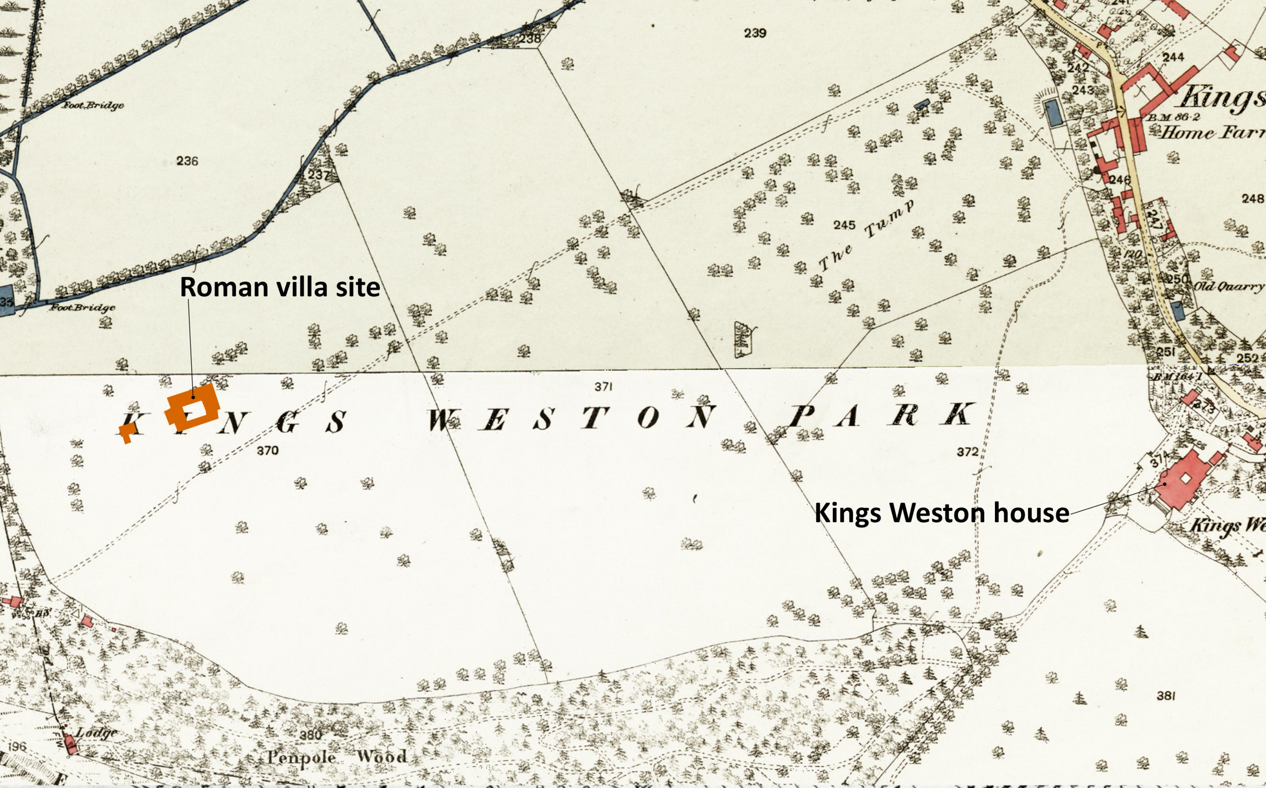
The south edge of the site, pale green on the plan, suggests a made surface running east-west across the site and possibly continuous with the clay floor identified in the post-war excavations. The location of the villa in the landscape, and this surface might represent an historic track passing across the front of the villa and perhaps a yard in the newly surveyed area. Projected eastwards, any road may have connected with several other Roman sites identified in Lawrence Weston. It’s a remote possibility that the Roman track alignment perpetuated into the modern era as a farm track known to have been in existence by 1720, and surviving in some form until 1947.
Below: The location of the Roman villa shown on maps of 1720, 1772, and 1946 and its relationship with an historic track passing through the historic parkland.
The location of the Roman villa shown on maps of 1720, 1772, and 1946 and its relationship with an historic track passing through the historic parkland.
The wall foundations, dark blue on the plan, clearly follow the same geometry as the villa itself, a strong indication that they were related and probably existed together. A north-south wall on the east side of the site seems to have matched another in the excavated area, leaving a gap of no more than 2m between them. It’s an odd arrangement; could it have been a narrow passage or lane? A water pipe appears to pass diagonally through both areas, probably feeding the bath house, but from where did the water come?
Another, similar, arrangement of parallel foundation walls occurs halfway across the new survey area with a narrower channel between the two that has been interpreted as a channel or culvert, perhaps another water system. Whether these walls extended above the historic ground level isn’t clear, but a demolition rubble layer was only found associated with the north end of the feature and possibly associated with buildings there that may stand over the channel feature.
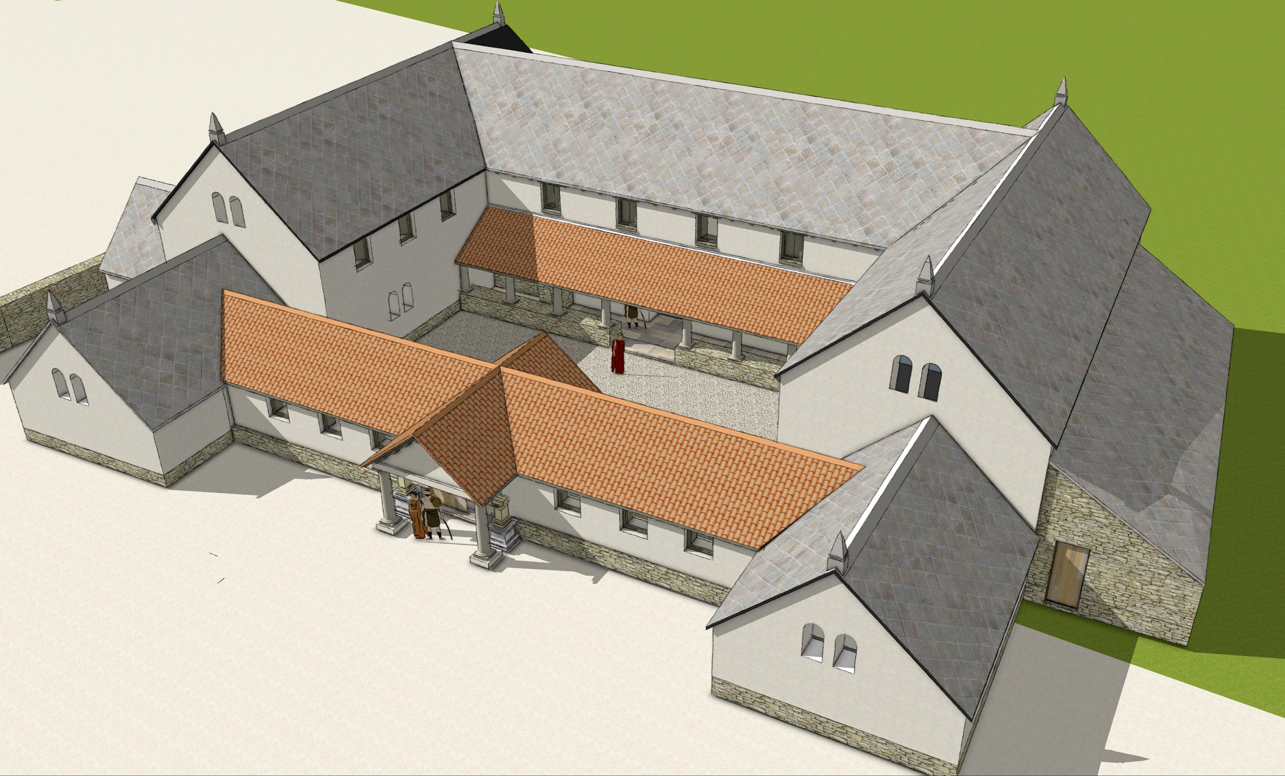
Our reconstruction of the Roman Villa viewed from the south east.
Probably the most exciting discover has been a building or complex of buildings gathered around the north-west corner of the site, structures previously unknown. The main structure is judged to be about 12m east-west and 8m north south, by no means large, but perhaps with attached structures and internal subdividing walls. Three areas of made floor surface have been identified at f,g, & h on the plan.
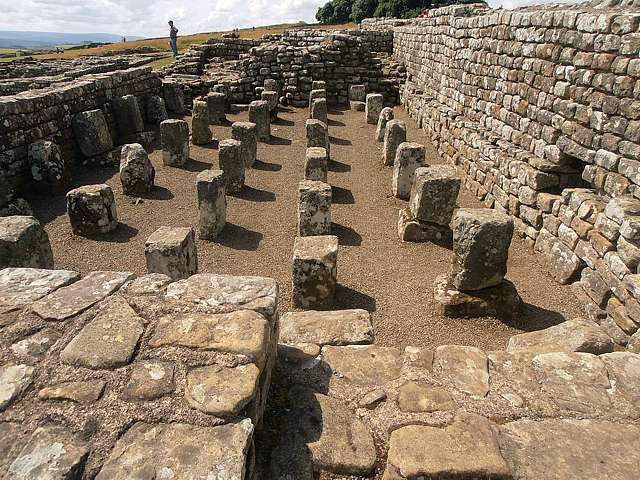
A granary at Housesteads Roman Fort with supporting pillars holding timber floors
Pale blue areas are suggested as loose rubble and debris, perhaps from collapsed buildings, and mainly distributed along the north side of the new area and suggested buildings. The dark green features are peculiar, indicating stacked masonry features like pillar bases or pilae that supported heated hypocaust floors. Without any enclosing walls, it’s possible that they supported a building raised off the ground, like a granary.
The purpose of the buildings will remain a mystery until any physical archaeological intervention takes place, but the villa would have been at the heart of an agricultural estate. It’s barns and other farm buildings have not previously been located, so it’s possible the area to the west provided these functions. The potential identification of a granary supported on piers might support that suggestion; this is, however, all hypothetical at this point.
The museum service hoped to explore this new area more in the future in old-fashioned archaeological dig where they hope to get community involvement. We’ll report more when details are released. But for now, why not take advantage of some forthcoming open days to quiz curators and archaeologists on the new discoveries? The villa will be open later this month as part of the national Festival of Archaeology for three days between 23 July—25 July. Full details can be found here as well as other dates this year when the villa will be open to the public
Planting bulbs along Shirehampton Road last year gave us the opportunity to inspect the Kings Weston estate’s smallest Listed building. The milestone is easily missed as you hurtle along the road, and not much more obvious amongst the boulders as a pedestrian. It’s a low vertical marker not even 3ft in height, the rough pennant hewn into a shallow arched top. It’s most obvious feature is a cast iron plate on its road side announcing “To Briftol 4” (the ‘f’ is a now obsolete way of writing ‘s’). Grade II Listed, this stone is described as an 18th Century milestone on Historic England’s register. So why is it there in the middle of the park?
This cast iron plaque and milestone constitute the smallest Listed building on the Kings Weston estate.
Turnpike Trusts were an early way of ensuring major highways were kept in good order. Before their advent it was down to local parishes to upkeep roads; this saw far from universal care taken of the country’s network, each parish taking their own measures, or not at all. Tolls collected by Turnpike Trusts were ringfenced for the maintenance and improvement of the trunk roads in their care. Bristol’s Trust was amongst the earliest in the country, being initiated in 1727, and developed into one of the most extensive networks.
An annotated aerial view of the park with, highlighted, the line of the first road taken on by the Turnpike Trust to better connect Bristol with Shirehampton and the Avon ferry across to Pill.
In 1758 Government passed an Act to enable the Trust to extend, taking on the roads to Shirehampton and the Pill ferry, and to the ferry across the Severn from Aust. It’s slightly unusual that an improved road to Shirehampton was such an early route, the village then being inconsequential and the area a rural destination. The Pill ferry may have given some justification for the improved route, but it’s possible the influence of the Southwell family was at play. The second Edward Southwell (1705-55) was elected MP for Bristol from 1739, and improved connections between Kings Weston and the city, and onwards from there to London, would have been in his interests. He already subscribed to the Trust.
The route to Shirehampton would pass through the Kings Weston estate, repairing and renewing the existing road to an improved standard, though surrounding landholders were expected to make contributions to such undertakings. The improvements opened out the north of Bristol and Shirehampton to “the fashionable throng at the Hot Wells” and throughout the 18th Century fed an embryonic trade in tourism enjoyed from the attractions of Kings Weston house, parkland, inn, and the natural delights of Kingsweston Hill and Penpole Point. Whatever influence Edward Southwell might have had in the decision to extend the roads, he never lived to enjoy them. Dying in 1755 the estate was inherited by his son Edward still in his minority.
The Shirehampton Road milestone was one of the features added by the Turnpike Trust for the convenience of travellers. It might reasonably have been added after their network was extended through the park in the 1750s. The two lodges, Park Lodge and Shirehampton Lodge, were not to do with the Trust however. Returning from his Grand Tour of Europe in 1761 the young Edward Southwell (the third), was keen to reinforce the bounds of his park and the turnpike road was something of a hinderance in that. With the assistance of his architect, Robert Mylne, and landscape designer, Thomas Wright, he set out to mark its boundary with lodges and gates. These were never intended for the collection of tolls, but were a statement of ownership, the gates being closed perhaps by night, or for general control of vehicles and riders passing through the estate.
Shirehampton Lodge looking towards the park in 1788, painted by Hieronymus Grimm. The gates straddle the turnpike road but were used only to demark the extents of the private estate. The scene looking in the opposite direction in around 1905. The park gates survived, a reminder that, although the road was now a public highway, that it traversed the private parkland. They were eventually removed in WWI when they were found to inhibit the movement of troops and vehicles to and from Avonmouth Docks.
The same year as his return to take command of his inheritance, the Turnpike commissioners received £30 from Southwell towards widening and ‘amending’ the road from Lamplighters hall and the Shirehampton towards Kingsweston. This may have involved the regrading of the present Park Hill.
A further Act, receiving Royal assent in 1819, added the route from Shirehampton to Gloucester, across Kingsweston Hill, to the Turnpike’s responsibilities. The route diverged from the original turnpike road at Park Lodge and, initially, adopted the road across the brow of the hill and past Kingsweston Inn before continuing towards Henbury. With the Trust’s objective to improve the roads in its care, the steep gradients up to the inn and down again were an urgent focus for works. Finding a solution was down to their chief engineer, Robert McAdam. We’ve previously looked at the history of the iron bridge in depth, but it’s worth noting the context into which its construction fits. In 1821 McAdam was engaged in work “lowering hill and building walls at Kingsweston Hill” , the cutting for which the bridge was required to span.
The plan submitted with the 1819 Act of Parliament with the pink section of road near Kingsweston Inn being that proposed to add to the rest of the network shown in yellow.
The tollgates were eventually removed from the Bristol network in 1867 and the roads passed to local highway authorities to maintain. At Kings Weston, we have two monuments, the bridge and the easily overlooked milepost, that stand testament to the benefits brought by the turnpike roads to local travellers and commerce alike; Would the Kings Weston estate have become so celebrated had they not permitted visitors such easy access?
One of the historic park lodges has just come on the market, albeit with some unconsented Listed building works along with it. Henbury Lodge was built to guard the park from the east, in the direction of the titular village. It’s not clear when it was built, possibly in the early 19th Century by the Miles family who moved into Kings Weston in 1834, but was certainly not amongst the first influx of architect-designed lodges from the earlier Georgian period. It’s possible that Thomas Hopper, or Henry Rumsey, both architects employed on refurbishing Kings Weston house in the 1840s, could be responsible.
Henbury Lodge in 1846 showing the original appearance with a parapet roof and central Venetian centrepiece between the projecting end bays.
The original design was for a polite Regency style building, symmetrically designed with a pair of shallow arches at either end, and a parapet roof. This was later ‘got at’ in the 1860s by Philip William Skinner Miles who fancied himself as something of an amateur architect. He added the steep pitched roof and decorative bargeboards, something of a signature feature that survives on a number of other buildings on the estate.
The lodge seen on Google street-view in 2009, before some of the render was stripped. It’s unclear when the modern porch appeared.
Unfortunately, the symmetry that was retained by Miles from the earlier building was damaged with the stripping of the render off the façade in about 2010, just before KWAG was established. The lopsided appearance may be more rustic but detracts from the intended formal appearance.
The house is on the market with Goodman & Lilley for £925,00. More details can be found here.
An aerial view of Henbury Lodge in its current condition.
Starting work restoring the Georgian lilypond has been a longstanding ambition of KWAG, and we finally got the opportunity in December. One of the issues we’ve faced has been that the pond and lodges don’t fall within the area managed by Parks, so insurance for our volunteers has been more difficult to agree through the Council’s Property team. Fortunately that hurdle was cleared late last year and a few hardy members began work just before Christmas.
a glimpse of the conditions faced by volunteers in December.
There has been a, literally, growing issue of self-seeded trees taking advantage of the choked pond and lower water levels to establish themselves in the shallower margins. This was particularly apparent alongside Napier Miles Road where views across the pond had virtually disappeared last summer. Whilst our work felling these is only a stop-gap measure, and they will likely re-grow, it’s important to arrest their growth before they become too large for us to manage and permanently damage the pond fabric.
With the help of wellies and waders, and not without some wet encounters, we traversed much of the pond area, cutting down pretty much all of the sallow saplings and carrying the waste away to discrete locations on the other side of the road. The ivy and brambles clogging the wall and ramps leading into the pond were also tackled, reopening the whole area again for the first time in years.
Reflections restored: the brambles and self seeded saplings have been caught just in time before many grew too large for our volunteers to tackle. Although they are likely to re-grow, this buys us more time to develop a plan for the whole area.
Eventually, the reeds that remain will completely choke the pond, and there was little sign of open water encountered during works. It’s important for the ecology of the pond that the reeds are removed at some point, but that challenge was well beyond our immediate ambitions for the day.
We’re incredibly grateful to everyone who lent a hand last month; this was something more unusually challenging than our usual work, but the results really speak for themselves. We continue work behind the scenes to develop a rescue plan for the area and lodges.
Before and after work viewed from Napier Miles Road. The Grade II-Star lodge building abuts the water cleanly once more. The northern ramp down to the pond is also revealed from beneath the brambles.
If it wasn’t for a couple of Bristol architecture students, J.B. Ackland and J.W. Tanner we’d know so little about Penpole Lodge, one of the lost garden buildings of Kings Weston. Surviving now just as a ruin, the building was once the culmination of views and walks through the landscaped grounds, but eventually succumbed to damage, decay, and cold Council pragmatism. Fortunately, before it was pulled down in 1950, these two students studiously recorded every detail.
Penpole Lodge in dilapidated condition shortly before demolition in 1950 (National Monument Record)
It was commonplace for architecture students to be given basic tasks of surveying historic buildings to learn surveying, drawing conventions, building construction and technology, scale and proportion, and architectural history. A number of survey drawings of historic Bristol buildings survive from this period, each measured and drawn as part of these university exercises. In the late years of the war Ackland and Tanner either chose, or were allotted Sir John Vanbrugh’s Penpole Lodge to carry out their study.
Tanner’s beautifully detailed sections through the lodge drawn during WWII. (National Monuments record)
By the time of their survey in 1943, the building was already badly damaged through neglect and the ill-treatment of the Home Guard when they commandeered it for a look-out. The Scouts, owners at the time, lamented the condition in which it was handed back to them. Sadly, the diary in which they recorded the decline didn’t note the attention of the Bristol students, but they must have had full and thorough access to be able to complete their set of drawings.
In all there are four drawings, split evenly between the two men. Tanner diligently tackled the plans, side elevation, and sections through the building, whilst Ackland took the more glamourous job of the main elevations and the tricky task of measuring and drawing all the profiles of ornamental details. Crisply drawn in pencil, they’re picked out in sepia coloured ink. They are an incredible and irreplaceable record of a building now lost, though it’s fate can hardly have been guessed by Tanner and Ackland at the time; It must have seemed unimaginable that demolition of a building by one of Britain’s most important architects could be contemplated, particularly at a time when so much had been lost in the war.
Ackland’s measured plans of Penpole Lodge, 1943. (National Monuments record) A host of intricate details are composed into a single drawing by J. B. Tanner. (National Monuments record)
The drawings remain the only illustration of the original facade that faced Kings Weston house across the estate. Unsurprisingly, this façade was the more ornamental, being viewed by the Southwell family and their guests, and later the Miles family. The many paintings, photos and postcards of the lodge are consistently taken from the common land on Penpole Point, never from the private grounds within. The interior too would be entirely unknown without the drawings, being the only record of the vaulted upper room and the layout of the tiny one-up-one-down cottage crammed into one side of the arch. KWAG based their 3D reconstruction and model of the building entirely on this precious record.
KWAG’s 3D model of Penpole Lodge showing the east facade, taken fromTanner’s elevation drawing.
Thank heavens that, unlike most student exercises, the drawings didn’t end up in a bin or forgotten in someone’s attic. Fortunate too, they were kept together as a set, at least, for a long time. Long after the loss of Penpole Lodge three of the drawings were lodged with Historic England’s National Monuments Record in Swindon where they can still be inspected today. We’ve recently returned to re-record them for our records. The fourth, the building elevations, was apparently loaned by Ackland to Bristol Architect and author Mike Jenner, possibly at the time he was writing the seminal Bristol: an Architectural History, but never returned. We were fortunate enough to be provided with a copy by Mr Jenner, but since his death in 2017 the location of the original is unknown. If you can help track it down, we’d be pleased to hear from you.
You can find a copy of the elevation drawing on our website here.
Maybe our quickest working party ever happened last month. The plan was to plant the remaining 3000 daffodil bulbs left over from October’s event where 6000 had been planted. You might assume that, with a smaller group, it might have taken us most of the day; In practice, the soft ground alongside Shirehampton Road saw volunteers power through the task in time for lunch at the house! This really highlights the poor quality of the stony ground we encountered either side of the Iron Bridge and how it prolonged the agony.
The team race eastwards along Shirehampton Road with bulb planting.
We had a turn-out of ten for the task of continuing the planting of daffodils alongside the road. Previous years have seen gradual extension of the band of flowers eastwards as bulbs have allowed. Planted between the back of pavement and the line of rocks we’ve now extended daffodils two thirds along the length of Shirehampton Road. Our fingers are crossed for a good Spring display.
The last of the bulbs get put to bed for this year.
In error, we ordered far more daffodil bulbs than we anticipated ahead of our annual Big Bulb Plant in October. Instead of 7000, volunteers who came along had the challenge of getting 9000 bulbs into the ground. Matters were exasperated too, by the quality of the ground around the historic Kings Weston iron bridge where we’d committed to plant. Earlier this year, with the support of the Save the Green Iron Bridge group and Janet Poole., donations were collected as part of the celebrations around the reopening of the bridge, and it seemed fit to decorate either side of the structure with these flowers. When it came to it, this was easier said than done.
Work begins on the east side of the bridge with plenty of family involvement.
The event began at 10am and gradually volunteer numbers grew throughout the morning. Those tasked with digging holes for the bulbs immediately found the ground to be poor, filled, as it was, with rubble sat there from decades before. Both sides of the bridge were heavy going, large lumps of building stone, brick, tarmac and all manner of material dumped there for inexplicable reasons and buried beneath the turf. This considerably slowed progress throughout the day, particularly on the west side. We still don’t know where all this material came from, but it could have been demolition rubble from the WWII use of the estate or some well-meaning council plan to level the ground around the bridge.
By lunchtime, opportunities to plant on the eastern side were exhausted, and everyone moved over to support the beleaguered team on the west. Aside from the challenge of the ground conditions, the day was perfect for the task, breaking out in sunshine by the end of the day, helpfully illuminating the slopes of Shirehampton Park as it sank towards the horizon. Fine tilth of soil left by digging bramble roots out sped progress as the afternoon progressed, and work was completed with the trimming of some self-seeded saplings that might overshadow the newly planted area.
A big gang of volunteers moves gradually along the grass from the bridge. The western side of the iron bridge proved the biggest challenge to dig.
We’re immensely grateful for everyone who came along throughout the day, no matter how long they were able to help for. We hope that the daffodils will now find their own path and root well in the troublesome ground before next spring and give us a fine display. Whilst we didn’t manage to get the full compliment in the ground, 6500 bulbs made it in. The surplus will form the basis of this month’s working party and go in along Shirehampton Road.
Kings Weston has a habit of bringing people together, and when, by chance, we began talking to Peter Floyd, former head of the city design team at Bristol City Council, we realised he had close connections with the house. Peter has kindly written a reminiscence from 1970, a pivotal year for the mansion on becoming redundant for a second time since WWII, and, as it happened, his own life. Peter writes:
“I worked for Bristol City Council (BCC)Planning Department in 1970. As an architect/planner I was head of Design Section responsible for some architectural aspects of the Planning, Engineering and Parks Departments. I was also a member of the Council of Bristol and Somerset Society of Architects (BSSA).
In the late 60’s public concern was growing about the risk of dereliction of both Ashton Court Mansion and also Kings Weston House. I had already organised a number of events for the BSSA and in 1970 chaired a group of members who decided to hold a Ball at BCC owned Ashton Court, to publicise its poor condition. Bristol City Council unexpectedly gave its permission and so we worked on the Ball organisation and design for 6 months, helped enthusiastically by artists Ann and Jerry Hicks. Our insurers then required assurance from BCC that the house was safe which was not forthcoming.
Peter Floyd (left) and Charles Gregory carry in some of the artist-design decorations for the ball.
The state of the house was revealed to the public which was furious. BCC was astonished that anyone was interested – However, the Ball had lost its venue.”
With the Bristol Society of Architects turfed out of Ashton Court they urgently looked for alternative venues to host their Restoration Ball. It so happened that Kings Weston house was shortly to be vacated by Bath University and with an uncertain future, so the titular restoration might equally apply to Vanbrugh’s mansion. With the help of Professor Ken Panter Kings Weston was acquired for one night only. Efforts were quickly refocussed on the new venue. The Evening Post reported on June 5th:
“Guests at tonight’s masked ball at Kings Weston House will be greeted by a scene to suit just about every taste. Wildly abstract works art by students of architecture will be dotted among potted palms loaned by Bristol Corporation parks department. And musically the sounds will range from Avon Cities jazz to period music played by a consort of recorders on the magnificent staircase of the Vanbrugh mansion.
A team of helpers led by ball-committee chairman Mr Peter Floyd, and member of the City Planning Department, were scurrying about Kings Weston today getting everything ready for the 350 guests who are paying four guineas a head for the pleasure. Mr Martin Fisher has been up night after night with his team of electricians devising lighting effects which will be the star attraction. Fifty spotlights, 30 stage lights and some cube-shaped lanterns will be dotted around the house. And from the outside Kings Weston will be flood-lit, providing a spectacle for the drivers passing along the M5.Groups of helpers have devised different decorative schemes for the sitting-out rooms on the ground and first floor. One has been transformed into a leafy bower, filled with borrowed rhododendrons, ivy, and laburnum. Others have been draped in fabric to give a tent-like effect. Mr Floyd, organising the ball for the Bristol Society of Architects, tells me it’s been touch-and-go to prepare the mansion in the two months since the decision to cancel the Restoration Ball at Ashton Court. “but we’ll be alright on the night,” he said.
Masks will be judged at midnight, soup and rolls will be served to those in need of sustenance at 1:30am, and Morris Dancers will be performing on the lawns during the evening.
Today’s coffee shop terrace seen in 1973, hinting at the plight of house and park at this time.
The ball more or less coincides with the departure from Kings Weston of the Bath University department of architecture. Professor Ken Panter said: I’m sad to leave, but it will be better for the students to move to Bath. We’ve been out on a limb here.”
The architects are hoping the ball will stimulate interest in the future of Kings Weston. There are awful fears that if nobody takes it over, it could, like Ashton Court, crumble once more into a state of decay.”
As it happened, the ball proved the catalyst for the house’s next evolution. Peter picks the story up again:
“Martin Kenchington, Avon County Architect, was at the Ball. He knew that Avon Police were looking for a building, persuaded them to take it and was able to save the structure and replace the famous arcaded chimneys.
The Ball at Kings Weston was a success as well as prolonging the life of two important buildings. As chairman, I was last man out and at 4am the next morning I proposed to my partner, who accepted – two buildings – and a wife!”
Last month we reported on the ‘official’ opening of the Kings Weston Iron Bridge, but on Sunday 14th July the community celebration very much in the earlier event to shade! The event enjoyed a lovely sunny afternoon and attracted around 200 guests who were serenaded by the Bristol Ukulele Band as they gathered at the Kings Weston end of the bridge. Proceedings began with the 126th Scouts (Sea Mills) parading over the newly open bridge with their troop banners arriving in the informal arena at the west side.
Janet Poole receives flowers in thanks on behalf of KWAG. (Bob Pitchford)
Sea Mills Scouts parade their banners over the bridge.
Janet Poole, who has been so instrumental in promoting and championing the repair of the bridge took a stand on the newly finished steps and addressed the crowd. She undertook to thank everyone involved with the project including the construction workers and support from KWAG during the lengthy process getting it reinstated. In gratitude for her tireless work, KWAG’s chair presented a bouquet of flowers on behalf of everyone who’d missed the bridge over the last nine years. Finally a ribbon was strung between the railings and ceremonially cut to re-inaugurate the historic structure.
A collection held during the event raised £121 towards KWAG’s Big Bulb Plant this October, for planting of daffodils either side of the bridge. The bridge was in very active use during event, with many guests taking their first opportunity to cross the bridge in its new raised location. Louis, a twelve year old drummer, closed proceedings with a rousing session in the sun. At the generous invitation of John Barbey of Kings Weston house, many people sauntered back to the vaulted coffee shop where complementary drinks and cake rounded off a beautiful and memorable celebration, a fit conclusion to a long-running saga.


